
U.S. Drought Map – August 13, 2013
Posted by feww on August 16, 2013
U.S. drought down fractionally, but more counties designated drought disaster areas
- As of August 13, 2013 about 57.30 percent of contiguous United States were affected by drought conditions, down slightly from 57.40 percent a week earlier.
- Some 45.26 percent of the land areas were covered by Moderate Drought (D1) to Exceptional Drought (D4), down from 45.49 percent.

US Drought Map as of August 13, 2013, released by US Drought Monitor on August 15, 2013.
Map of U.S. Drought Disaster Areas
As of August 14, 2013 at least 1,317 U.S. counties were designated as primary or contiguous agricultural disaster areas due to the ongoing drought.
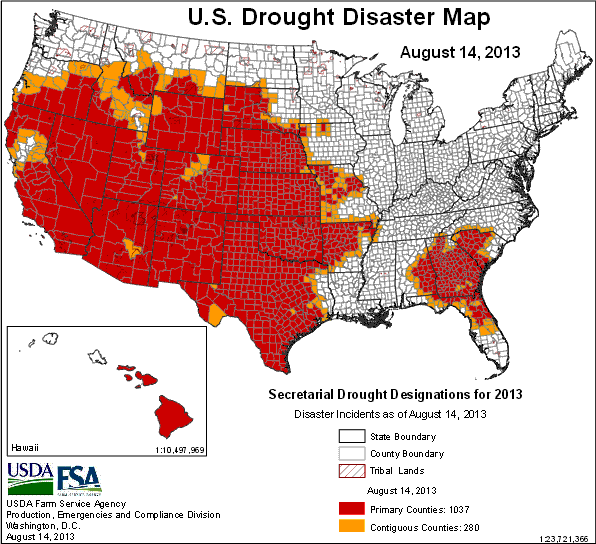
U.S. Drought Disaster Map as of August 14, 2013. At least 1,317 counties, or 42% of all counties*, were designated as drought disaster areas. [The figure includes both primary and contiguous disaster designations.] Source: USDA. Map enhanced by FIRE-EARTH.
*[U.S. has a total of 3,143 counties and county-equivalents.]
Related Links
- Drought Disaster Declared in 37 Counties Across 5 States August 15, 2013
- Agricultural Disaster Declared for Dozens of U.S. Counties August 8, 2013
- U-S Drought 2013: Fueled by Heat from Hell? January 31, 2013 [FIRE-EARTH Forecast]
- US: Drought Disaster 2013 [Index Page]
- Agricultural Disasters Index

Leave a comment