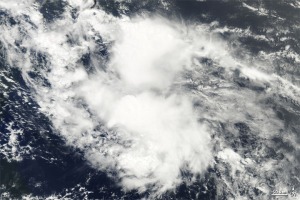
Tropical Storm Colin – Satellite Images
Posted by feww on August 4, 2010
Tropical Depression Four Strengthens into Tropical Storm Colin
Colin is the third tropical storm of the 2010 Atlantic hurricane season.

TS COLIN – IR (NHC Enhancement) Satellite Image. Source: CIMSS. Click image to enlarge.
TS COLIN Summary of status at 5:45UTC on August 04, 2010 [Estimated by Fire-Earth]
- Location: Near 16.9N 57.5W
- Position: About 465 km (250NM) NNE (27.3 degrees) of Barbados
- Max Sustained Winds: 60 km/hr
- Wind Gusts: 85 km/hr
- Movement: WNW (290 degrees) at 30 km/hr
- Max Wave Heights: 1.2m (4 feet)

A natural-color image of Tropical Storm Colin captured by MODIS on NASA’s Terra on 9:40 a.m. EDT (13:40 UTC). Click image to enlarge. Download large image (3 MB, JPEG)

Image shows the storm’s rainfall amounts, as measured by NASA’s TRMM, on August 2, 2010. Source: NASA. Click image to enlarge. Download large image (121 KB, JPEG)
This entry was posted on August 4, 2010 at 7:22 am and is filed under Atlantic hurricane season, atlantic hurricanes 2010, environment, storm, Tropical Storm 04L, Tropical Storm Colin Satellite Images, tropical storms 2010. Tagged: Atlantic hurricane season 2010, barbados, Tropical Storm Colin. You can follow any responses to this entry through the RSS 2.0 feed. You can leave a response, or trackback from your own site.
One Response to “Tropical Storm Colin – Satellite Images”
Leave a comment Cancel reply
This site uses Akismet to reduce spam. Learn how your comment data is processed.

bre said
[Thank you for kind words. Please feel free to post a link to FEWW. Moderator]