Archive for the ‘earthquake’ Category
Posted by feww on June 8, 2014
SEISMIC HAZARD
HEIGHTENED GLOBAL SEISMICITY
SCENARIOS 08, 07
.
M5.5 strikes near Noatak, AK followed by dozens of aftershocks
Centered at 67.719°N, 162.385°W, the event occurred at a depth of 16.4km (10.2mi), followed by at least two dozen aftershocks.
EQ Details [USGS/EHP]
Magnitude: 5.5Mw
Event Time: 2014-06-07 at 04:43:33 UTC
Location: 67.719°N 162.385°W depth=16.4km (10.2mi)
Nearby Cities:
- 35km (22mi) NE of Noatak, Alaska
- 728km (452mi) WNW of Fairbanks, Alaska
EQ Location Map

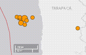
1 Day, All Magnitudes Worldwide: 171 earthquakes – DownloadUpdated: 2014-06-08 2014-06-08 04:47:29 UTC– 56 earthquakes in the larger Alaska map area. Source: USGS/EHP
IMPORTANT NOTICE: FIRE-EARTH EQ Forecast
The next detailed FIRE-EARTH Earthquake Forecast will be released together with Bulletin NO. 104 later today (June 8, 2014).
Volcanic Activity in Alaska
PAVLOF VOLCANO (VNUM #312030)
55°25’2″ N 161°53’37” W, Summit Elevation 8261 ft (2518 m)
Current Volcano Alert Level: WATCH
Current Aviation Color Code: ORANGE
The eruption of Pavlof Volcano continues. Seismicity remains steady and unchanged in the past 24 hours. No thermal or ash signals were visible in cloudy satellite and web camera images.
- Shishaldin: Color Code: ORANGE/ Alert Level WATCH
- Cleveland: Color Code YELLOW / Alert Level ADVISORY
- Veniaminof: Color Code YELLOW / Alert Level ADVISORY
Related Links
Posted in earthquake, Earthquake cluster, Earthquake Hazard, Earthquake news, earthquake update, Global Disaster watch, significant events | Tagged: 8 June 2014, Alaska, Bulletin NO. 104, earthquake, FIRE-EARTH earthquake FORECAST, Noatak, Pavlof, SCENARIO 07, SCENARIO 08, Shishaldin | Leave a Comment »
Posted by feww on April 21, 2014
ENVIRONMENTAL HOLOCAUST
FRACKING-RELATED SEISMIC HAZARD
CONTINUED SEISMICITY IN OKLAHOMA
.
Another M4.0 quake Strikes OK
A magnitude 4.0 earthquake struck about 13km N of Edmond, Oklahoma at a depth of 7.6km (4.7mi). The event was followed by a magnitude 3.7 shocks which struck nearby 24 minutes later.
EQ Details
Magnitude: 4.0Mw
Event Time: 2014-04-20 19:07:13 UTCe
Location: 35.770°N 97.500°W depth=7.6km (4.7mi)
Nearby Cities:
- 13km (8mi) SSW of Guthrie, Oklahoma
- 29km (18mi) NNE of Warr Acres, Oklahoma
- 30km (19mi) NNE of Bethany, Oklahoma
- 33km (21mi) N of Oklahoma City, Oklahoma
EQ Location Map

Earthquake Location Map: Source: USGS/EHP
FIRE-EARTH Earthquake Forecast
The next detailed FIRE-EARTH Earthquake Forecast will appear in Bulletin NO. 90, which will be released on April 23.
Related Links
- M4.0 Strikes near Perry, Oklahoma April 20, 2014
- Ohio Finally Links Fracking to Earthquakes April 12, 2014
- Heightened Seismicity Continues in Oklahoma April 8, 2014
- Another Shallow Quake Strikes Oklahoma April 6, 2014
- Significant Quake Rattles Oklahoma April 5, 2014
- Significant Quakes Strike Oklahoma, Wyoming March 30, 2014
- Another Significant Quake Rattles OKC March 22, 2014
- More Quakes Rattle Oklahoma, Kansas; Ohio Stops Fracking Posted on March 12, 2014
- Another Swarm of Shallow Quakes Strikes Close to Oklahoma City February 18, 2014
- More Quakes Strike Oklahoma February 11, 2014
Posted in earthquake, earthquake forecast, Earthquake Hazard, earthquake report, Global Disaster watch, global disasters, Significant Event Imagery, significant events | Tagged: Bulletin NO. 90, FIRE-EARTH earthquake FORECAST, FRACKING-RELATED quake, Oklahoma City, Oklahoma Earthquake | Leave a Comment »
Posted by feww on April 15, 2014
SEISMIC HAZARD
.
Strong quake occurs ENE of subantarctic volcanic island
EQ Details
Magnitude: 6.9Mw
Event Time: 2014-04-15 03:57:02 UTC
Location: 53.527°S, 8.704°E depth=11.7km (7.3mi)
Nearby Cities
- 364km (226mi) ENE of Bouvet Island
- 2,279km (1416mi) SSW of Hermanus, South Africa
EQ Location Map

Earthquake Location Map. Source: USGS/EHP
FIRE-EARTH Earthquake Forecast
The next FIRE-EARTH Earthquake Forecast will appear in Bulletin No. 86, to be released on April 15.
Posted in earthquake, Earthquake Hazard, earthquake report, Significant Event Imagery, significant events | Tagged: Bouvet Island, Bulletin No. 86, FIRE-EARTH earthquake FORECAST, Islas Orcadas Fracture Zone, Shaka Ridge, subantarctic volcano | Leave a Comment »
Posted by feww on April 6, 2014
SEISMIC HAZARD
WIDESPREAD DAMAGE
.
Earthquake affects more than 68,000 people, leaves 21,000 homeless
A magnitude 5.3 quake struck Yongshan County at a depth of 13 km, at 6:40 a.m. Saturday local time damaging at least 2,731 homes (75 destroyed), affecting more than 68,000, and leaving 21,000 displaced. At least 25 people were injured, authorities said.
The quake also damaged numerous other buildings including 48 schools across six towns, reported Xinhua.
Xiluodu Hydropower Project
“Yongshan is home to the Xiluodu hydropower project, China’s second largest hydropower station, only 15 km from the epicenter. Rumors have spread that the quake was caused by the power station,” said the report.
“The area has a history of quakes, [Zhang Jianguo of Yunnan Disaster Prevention Research Institute] said, and quakes caused by reservoirs usually have quite shallow epicenters, at a depth of around 4 km, while the epicenter of Saturday’s quake was 13 km deep.”

Original caption: A villager stands besides her damaged house in Yongshan County, southwest China’s Yunnan Province, April 5, 2014. At least 25 people were injured and 21,000 relocated when a 5.3-magnitude earthquake stuck Yongshan early on Saturday. (Xinhua/Hu Chao). More images…
Posted in earthquake, earthquake damage, Earthquake news, Global Disaster watch, global disasters, significant events | Tagged: China Earthquake, hydropower, Xiluodu hydropower project, Yongshan quake, Yunnan | Leave a Comment »
Posted by feww on April 3, 2014
WARNING: NEW EARTHQUAKE FORECAST
MEGA EARTHQUAKE IN PERU-CHILE TRENCH
.
WARNING: MEGA EARTHQUAKE FORECAST [REV. 2]
FIRE-EARTH Models show a MEGA EARTHQUAKE could strike along Peru-Chile Trench in the next three weeks. Some of the quake details have now been revised.
FIRE-EARTH FORECAST: Magnitude 9.4Mw could strike Peru-Chile Trench April 4 – 30, with a probability of 54%.
See below for revised details:
Forecast Earthquake Details
Magnitude: 9.4Mw (Provisional )
Location: 22.7°S, 70.8°W (Provisional )
Depth: 22km (Provisional )
Date/Time: April 4 – 30, 2014 (Peak April 10)
Probability: 54% (provisional)
Tsunami Forecast
Large, destructive tsunami waves HIGHLY PROBABLE.
Initial forecast for the Mega Quake posted HERE.
CAUTION
1. FIRE-EARTH Models used for the above forecast are unique, proprietary tools owned by the blog’s science team. There are NO similar models anywhere on this planet. Any earthquake forecasts that go beyond the traditional “menstruation cycles” are “scholarly” forgeries, plagiarizing our research.
2. The forecast is subject to change, or withdrawal.
3. See also DISCLAIMER posted HERE.
.
Previous FIRE-EARTH Earthquake Forecast for Chile
On March 17, 2014, FIRE-EARTH posted an Earthquake Forecast for Chile, which was immediately hacked. The update was posted at Another Significant Aftershock Strikes Coastal Chile, on the same day, which stated:
FIRE-EARTH Models show a large earthquake could strike along Peru-Chile Trench in the coming weeks.
Tsunami Forecast: Large tsunami waves highly probable.
Forecast Details
- Magnitude: ≥8.2Mw
- Location: 23.6°S, 70.8ºW
- Depth: 30km
- Time: March 17 – April 29, 2014
- Probability of Occurrence: 0.75
- Total Earthquake Energy for the Episode ≥ 0.25EJ
Related Links
FIRE-EARTH Earthquake Forecasts for California and Japan
Due to the reasons explained previously on this blog, FIRE-EARTH Science Team has suspended its research on California and Japan seismicity.
Posted in earhquake forecast, earthquake, earthquake forecast, Earthquake probability, Global Disaster watch, significant events | Tagged: chile earthquake, earthquake warning, FIRE-EARTH earthquake FORECAST, mega earthquake, Peru-Chile Trench, Tsunami Forecast | 1 Comment »
Posted by feww on March 24, 2014
SEISMIC HAZARD
.
More aftershocks hit coastal N Chile
Most significant aftershocks to strike near Iquique, Chile in the past 24 hours include
- M5.3 (19.744°S, 70.811°W) about 89km WNW of Iquique, Chile 2014-03-23 at 20:23:03UTC, at a depth of 23.4 km
- M6.0 (19.905°S, 70.934°W) about 87km NW of Iquique, Chile 2014-03-24 at 18:20:03 UTC, at a depth of 34.6 km
At least 9 other aftershocks measuring 4.4Mw or greater struck the area as of 2014-03-24 8:54:41 UTC.
Earthquake Location Map. Source: USGS/EHP
FIRE-EARTH Earthquake Forecast for Chile (March 17, 2014)
FIRE-EARTH Models show a large earthquake could strike along Peru-Chile Trench in the coming weeks.
Tsunami Forecast: Large tsunami waves highly probable.
Forecast Details
- Magnitude: ≥8.2Mw
- Location: 23.6°S, 70.8ºW
- Depth: 30km
- Time: March 17 – April 29, 2014
- Probability of Occurrence: 0.75
- Total Earthquake Energy for the Episode ≥ 0.25EJ
See also
Posted in earhquake forecast, earhquake hazard, earthquake, earthquake forecast, Earthquake news, earthquake report, Global Disaster watch, Significant Event Imagery, significant events | Tagged: chile, chile earthquake, Chile earthquake forecast, earthquake 2014, peru, peru earthquake, Peru-Chile Trench | Leave a Comment »
Posted by feww on March 10, 2014
SEISMIC HAZARD
.
Strong Earthquake Strikes 81km West Of Eureka, California
Magnitude 6.9 earthquake struck offshore 81km west of Eureka, California (population: 27,000) at 2014-03-10 05:18UTC.
The quake was preceded by at least 3 foreshocks and followed by 10 aftershocks, with the largest measuring 4.6Mw, as of posting.
Earthquake Location Map
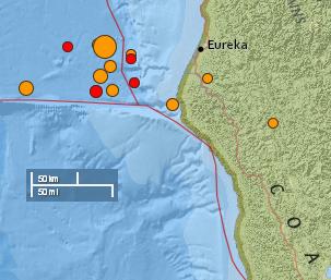
Approximate location of the Eureka quake, fore- and aftershocks, as of 07:10UTC March 10, 2014. Source: USGS/EHP
Earthquake Details
Event Time: 2014-03-10 05:18:12 UTC
Location: 40.821°N, 125.128°W depth=7.0km (4.3mi)
Nearby Cities:
- 77km (48mi) WNW of Ferndale, California
- 81km (50mi) W of Eureka, California
- 85km (53mi) WNW of Fortuna, California
- 87km (54mi) W of McKinleyville, California
- 398km (247mi) NW of Sacramento, California
- Source: USGS/EHP
TSUNAMI EVALUATION
NO Tsunami threat to ALASKA/ BRITISH COLUMBIA/ WASHINGTON/ OREGON AND CALIFORNIA
A WIDESPREAD DESTRUCTIVE TSUNAMI THREAT DOES NOT EXIST BASED ON HISTORICAL EARTHQUAKE AND TSUNAMI DATA.
THE U.S. NATIONAL TSUNAMI WARNING CENTER WILL ISSUE INFORMATION REGARDING ANY LOCAL TSUNAMI THREAT TO COASTS NEAR THE EARTHQUAKE EPICENTER.
Other Significant Quake(s)
M5.8 – 37km SW of Santiago Pinotepa Nacional, Mexico
Event Time: 2014-03-10 00:38:15 UTC
Location: 16.080°N,98.267°W; depth=10.0km (6.2mi)
Nearby Cities:
- 37km (23mi) SW of Santiago Pinotepa Nacional, Mexico
- 68km (42mi) SSE of Ometepec, Mexico
- 131km (81mi) WNW of Puerto Escondido, Mexico
- 140km (87mi) SE of San Marcos, Mexico
- 381km (237mi) SSE of Mexico City, Mexico
Related Links and Recent U.S. Quakes
- Another Swarm of Shallow Quakes Strikes Close to Oklahoma City February 18, 2014
- More Quakes Strike Oklahoma February 11, 2014
- Significant Earthquakes Strike Oklahoma December 29, 2013
- M4.5 Quake Strikes NE Edmond Oil and Gas Field, Oklahoma December 8, 2013
- 41 Earthquakes Strike Oklahoma in November December 1, 2013
- Earthquake No. 19 Strikes N. Texas November 29, 2013
- Two More Quakes Strike North Texas November 29, 2013
- Oil Drilling Likely Caused Texas Earthquake Posted on May 17, 2009
- M3.3 Quake Strikes Azle, Texas Posted on November 25, 2013
- FEWW Earthquake Links
Posted in earthquake, Earthquake Hazard, earthquake report, Eureka, Eureka quake | Tagged: California earthquake, earthquake 2014, Mexico, Pacific Ring of Fire, Santiago Pinotepa Nacional, tsunami, U.S. | Leave a Comment »
Posted by feww on February 26, 2014
Seismic Hazard
.
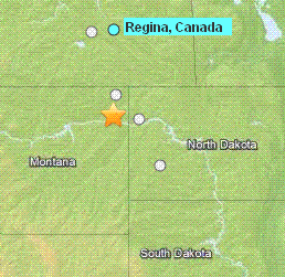
Shallow earthquake strikes S of Plentywood, Montana
The quake struck at a depth of 5km about 59km S of Plentywood, NE Montana.
Meantime, at least 16 shocks measuring between M2.5 and 3.5 occurred in the state of Oklahoma in the past 7 days.
Preferred Location Parameters
Event Time: 2014-02-25 22:45:38 UTC
Magnitude: 3.8 mb_lg (± 0.07)
Location: 48.250°N, 104.699°W
Dept:h 5.0 km (± 2.0 km)
Number of Phases Used 12
Minimum Distance 44.6 km (0.40°)
Travel Time Residual 0.63 sec
Azimuthal Gap 148°
Nearby Cities:
- 59km (37mi) S of Plentywood, Montana
- 81km (50mi) W of Williston, North Dakota
- 244km (152mi) S of Regina, Canada
Review Status MANUAL
Event ID usc000my5t [USGS/EHP]
Related Links
- Another Swarm of Shallow Quakes Strikes Close to Oklahoma City February 18, 2014
- More Quakes Strike Oklahoma February 11, 2014
- Significant Earthquakes Strike Oklahoma December 29, 2013
- M4.5 Quake Strikes NE Edmond Oil and Gas Field, Oklahoma December 8, 2013
- 41 Earthquakes Strike Oklahoma in November December 1, 2013
- Earthquake No. 19 Strikes N. Texas November 29, 2013
- Two More Quakes Strike North Texas November 29, 2013
- Oil Drilling Likely Caused Texas Earthquake Posted on May 17, 2009
- M3.3 Quake Strikes Azle, Texas Posted on November 25, 2013
- FEWW Earthquake Links
Posted in earthquake, Significant Event Imagery, significant events | Tagged: earthquakes 2014, Montana, Oklahoma, Plentywood, Seismic Hazard, US earthquakes, US earthquakes 2014 | Leave a Comment »
Posted by feww on February 15, 2014
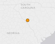
M4.1 strikes near Edgefield, South Carolina
A shallow quake measuring at least 4.1Mw struck 12km WNW of Edgefield, SC, at 03:23:38 UTC Saturday.
Earthquake Details
- Event Time: 03:23:38 UTC on 2014-02-15
- Location: 33.812°N 82.063°W
- Depth: 4.8km (3.0mi)
- Nearby Cities
- 12km (7mi) WNW of Edgefield, South Carolina
- 31km (19mi) NNE of Evans, Georgia
Earthquake Location Map
Source: USGS/EHP
Related Links
Posted in earthquake, Earthquake news | Tagged: Edgefield quake, georgia, South Carolina, US earthquake, US earthquakes 2014 | Leave a Comment »
Posted by feww on January 16, 2014
M3.8 Earthquake Strikes 11km E of Villa Park, California
The event was followed by another shock measuring M3.2, which occurred 5km N of Fontana, California.
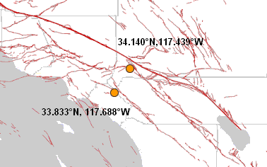
Earthquake Location Map. Source: USGS/EHP
Earthquake Details
Event Time: 2014-01-16 07:40:06 UTC
Location: 33.833°N, 117.688°W depth=8.5km (5.3mi)
Nearby Cities
- 12km (7mi) WSW of Corona, California
- 13km (8mi) ESE of Yorba Linda, California
- 19km ENE of Santa Ana, California
- 21km E of Anaheim, California
- 57km ESE of Los Angeles, California
Second Event
M3.2, 2014-01-16 09:50:03 UTC, 34.140°N 117.439°W depth=1.7km (1.1mi), 5km N of Fontana, California
Related Links
Posted in earthquake, Earthquake news, Significant Event Imagery, significant events | Tagged: california, earthquake 2014, Elsinore Fault Zone, Fontana, Salton Sea, San Andreas Fault, San Jacinto Fault Zone, Sierra Madre Fault Zone, Soledad, U.S. Earthquake | Leave a Comment »
Posted by feww on December 6, 2013
“Strong” quakes strike along the Alpine Fault
The first quake registered magnitude 4.7 and struck about 5km south-west of Seddon, upper South Island, rattling buildings in downtown Wellington, according to local reports.
Magnitude: 4.7
Depth: 21 km
Epicenter: 41.70ºS, 174.03ºE
Location 5 km south-west of Seddon
Date/Time: December 6 2013 at 0:45:00UTC
Intensity: Strong (MM scale)
Source: Geonet
The second quake, also measuring magnitude 4.7, struck 10 km north-west of Milford Sound near the lower South Island shaking Milford Sound, about two hours later.
Magnitude: 4.7
Depth: 16 km
Epicenter: 44.58ºS, 167.88ºE
Location: 10 km north-west of Milford Sound
Date/Time: December 6 2013 at 02:56:30UTC
Intensity: Strong (MM scale)
Source: Geonet
The quakes followed another significant quake, measuring magnitude 4.2, which struck at a depth of 5km, about 20 km west of Reefton (42.03ºS, 171.65ºE) on Sunday, according to Geonet records.
Be sure to search blog content for important information concerning NZ earthquakes.
Posted in earthquake, earthquake 2013, Significant Event Imagery, significant events | Tagged: Alpine Fault, Australian plate, Challenger Plateau, Chatham Rise, Hikurangi Trench, Kermadec trench, Marlborough Fault System, Milford Sound, NZ earthquake, Pacific Plate | Leave a Comment »
Posted by feww on October 15, 2013
Powerful M7.1 Quake Causes Much Destruction in Central Philippines+
Philippine authorities have declared declared states of calamity in Bohol and Cebu Provinces after a powerful quake killed at least 80 people and left about 180 others injured, destroying or damaging scores of homes, buildings, historical churches, and causing widespread damage to public infrastructure across the famed tourist islands.
The M7.1 [revised by USGS/EHP] quake struck the island province of Bohol, about 2km NE of Catigbian, Philippines at a depth of about 20km [revised by USGS/EHP] at 00:12:32 UTC on Tuesday, October 15, 2013.
Centered at 9.866°N, 124.011°E, the deadly quake struck about 619km (385mi) SSE of Manila, according to USGS/EHP.
The mainshock was followed by large swarms of at least 400 aftershocks including 10 tremors measuring 5.0Mw or greater, as of posting.
The quake has affected tens of thousands of people, most of whom were left without electricity, tap water, communication or transportation links.
Half dozen bridges have collapsed, and many road have buckled due to the quake energy.
Related Links
Posted in earhquake hazard, earthquake, earthquake damage, Earthquake death, earthquake energy, Earthquake news, earthquake report, Global Disaster watch, global disasters, global disasters 2013 | Tagged: Balilihan quake, Bohol earthquake, Bohol Island, Catigbian, Cebu, Cebu island, earthquake, earthquake alert, earthquake damage report, Philippines quake, State of Calamity, State of Disaster | 2 Comments »
Posted by feww on September 25, 2013
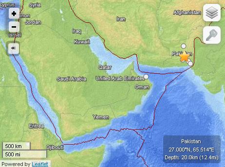
Death toll from powerful quake rises to 100, with more than 200 others injured in Pakistan
The quake measuring 7.7Mw struck 66km north-northeast of Awaran, a remote part of the Baluchistan province in southwestern Pakistan.
The quake and its aftershocks destroyed scores of mud houses near the epicenter in sparsely populated Baluchistan region.
EQ Details
- Event Time: 2013-09-24 11:29:48 UTC
- Location: 27.000°N, 65.514°E
- Depth: 20.0km (12.4mi)
- Nearby Cities
- 66km (41mi) NNE of Awaran, Pakistan
- 116km (72mi) NW of Bela, Pakistan
New Island Emerges from Arabian Sea
The powerful quake caused the seabed to rise and form a small island in the Arabian Sea, about 500 meters off Pakistan’s coastline.
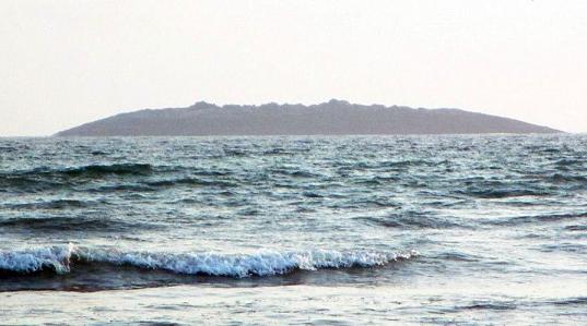
Powerful earthquake hits Baluchistan, forcing the sea bed to rise and form a new island in the Arabian Sea. Image sourced from news.cn/gmw.cn
EQ Location Map
Related Links
Posted in deadly earthquakes, destructive interplate earthquakes, earthquake, Earthquake aftermath, earthquake damage, Earthquake death, Earthquake Hazard, Earthquake news | Tagged: Arabia plate, Arabian Sea, Awaran, Awaran quake, Baluchistan province, earthquake 2013, Earthquake location map, Eurasia plate, India plate, Karachi, Makran subduction zone, Pakistan Earthquake, pakistan quake | Leave a Comment »
Posted by feww on August 31, 2012
M7.9 Quake Strikes E Philippines, Tsunami Warning in Effect
Powerful earthquake struck Philippine Islands Region about 106 km (66 miles) ESE (102°) from Guiuan, Samar, Philippines, USGS/EHP reported.
TSUNAMI STATUS: WARNING, WATCH
Expanding Regional Warning
TSUNAMI WARNING:
Indonesia, Philippines, Belau, Yap, Taiwan, Japan, Guam, N. Marianas, Papua New Guinea A Tsunami Watch is in Effect For Chuuk, Marcus Is., Kosrae, Pohnpei, Marshall Is., Wake Is., Solomon Is., Russia, Nauru
BULLETIN
TSUNAMI MESSAGE NUMBER 1 – NWS PACIFIC TSUNAMI WARNING CENTER EWA BEACH HI, 2:57AM HST FRI AUG 31, 2012
A TSUNAMI WATCH IS ISSUED FOR THE STATE OF HAWAII EFFECTIVE AT 02:57AM HST.
EVALUATION: BASED ON ALL AVAILABLE DATA A TSUNAMI MAY HAVE BEEN GENERATED BY THIS EARTHQUAKE THAT COULD BE DESTRUCTIVE ON COASTAL AREAS EVEN FAR FROM THE EPICENTER. AN INVESTIGATION IS UNDERWAY TO DETERMINE IF THERE IS A TSUNAMI THREAT TO HAWAII.
IF TSUNAMI WAVES IMPACT HAWAII THE ESTIMATED EARLIEST ARRIVAL OF THE FIRST TSUNAMI WAVE IS 12:28PM HST FRI 31 AUG 2012

Earthquake Location Map. Source: USGS/EHP
EQ Details [USGS]
- Date-Time: Friday, August 31, 2012 at 12:47:34 UTC
- Location: 10.828°N, 126.677°E
- Depth: 34.9 km (21.7 miles)
- Region: Philippine Islands Region
- Distances:
- 106 km (66 miles) ESE (102°) from Guiuan, Samar, Philippines
- 175 km (109 miles) NE (48°) from Surigao, Mindanao, Philippines
- 749 km (465 miles) SE (124°) from MANILA, Philippines
- Location Uncertainty: horizontal +/- 13.7 km (8.5 miles); depth +/- 5.8 km (3.6 miles)
EQ Details [GEOFON Program]
- Magnitude: 7.5 (Mw)
- Time: 2012-08-31 12:47:32.2 UTC
- Epicenter: 126.82°E 10.82°N
- Depth: 10 km
- Status: C – confirmed
Other Significant Quakes
- M6.8; 71.461°N, 10.919°W; 99km NW of Olonkinbyen, Svalbard and Jan Mayen [935km (581mi) NNE of Reykjavik, Iceland;]2012-08-30 at 13:43UTC, at a depth of 9.9km.
Related Links
Global Disasters: Links, Forecasts and Background
GLOBAL WARNING
Posted in earthquake, Earthquake Hazard, earthquake report, earthquakes 2012, environment, global earthquakes | Tagged: earthquake, Jan Mayen, Olonkinbyen quake, Philippines quake, REYKJAVIK, Svalbard, tsunami, tsunami warning | Leave a Comment »
Posted by feww on April 11, 2012
M8.7 Earthquake strikes off the west coast of northern Sumatra, Indonesia
The earthquake was epicentered at 2.348°N, 93.073°E and occurred at a depth of 32km, according to USGS.
Distances:
- 435 km (270 miles) SW (215°) from Banda Aceh, Sumatra, Indonesia
- 964 km (599 miles) W (265°) from KUALA LUMPUR, Malaysia

Earthquake Location Map. Source: USGS. Map enhanced by FIRE-EARTH
[NOTE: USGS has since revised quake magnitude to 8.6Mw]

Internet Intensity Map. (Source USGS).
Tsunami Alert
TSUNAMI BULLETIN NUMBER 002
PACIFIC TSUNAMI WARNING CENTER/NOAA/NWS
ISSUED AT 0945Z 11 APR 2012
THIS BULLETIN IS FOR ALL AREAS OF THE INDIAN OCEAN.

... AN INDIAN-OCEAN-WIDE TSUNAMI WATCH IS IN EFFECT ...

A TSUNAMI WATCH REMAINS IN EFFECT FOR

 INDONESIA / INDIA / AUSTRALIA / SRI LANKA / MYANMAR / THAILAND /
 MALDIVES / UNITED KINGDOM / MALAYSIA / MAURITIUS / REUNION /
 SEYCHELLES / OMAN / PAKISTAN / SOMALIA / MADAGASCAR / IRAN /
 UAE / YEMEN / COMORES / MOZAMBIQUE / KENYA / TANZANIA /
 CROZET ISLANDS / BANGLADESH / KERGUELEN ISLANDS / SOUTH AFRICA /
 SINGAPORE
AN EARTHQUAKE HAS OCCURRED WITH THESE PRELIMINARY PARAMETERS ORIGIN TIME - 0839Z 11 APR 2012 COORDINATES - 2.3 NORTH 93.1 EAST LOCATION - OFF W COAST OF NORTHERN SUMATRA MAGNITUDE - 8.7

EVALUATION

 EARTHQUAKES OF THIS SIZE HAVE THE POTENTIAL TO GENERATE A
 WIDESPREAD DESTRUCTIVE TSUNAMI THAT CAN AFFECT COASTLINES ACROSS
 THE ENTIRE INDIAN OCEAN BASIN.

 HOWEVER - IT IS NOT KNOWN THAT A TSUNAMI WAS GENERATED.  THIS
 WATCH IS BASED ONLY ON THE EARTHQUAKE EVALUATION. AUTHORITIES IN
 THE REGION SHOULD TAKE APPROPRIATE ACTION IN RESPONSE TO THE
 POSSIBILITY OF A WIDESPREAD DESTRUCTIVE TSUNAMI. WE ARE STILL
 WAITING FOR CONFIRMATION OF TSUNAMI FROM NEAREST SEA-LEVEL
 STATIONS.

ESTIMATED INITIAL TSUNAMI WAVE ARRIVAL TIMES AT FORECAST POINTS
WITHIN THE WARNING AND WATCH AREAS ARE GIVEN BELOW. ACTUAL
ARRIVAL TIMES MAY DIFFER AND THE INITIAL WAVE MAY NOT BE THE
LARGEST. A TSUNAMI IS A SERIES OF WAVES AND THE TIME BETWEEN
SUCCESSIVE WAVES CAN BE FIVE MINUTES TO ONE HOUR.

 LOCATION         FORECAST POINT     COORDINATES     ARRIVAL TIME [Z, UTC, GMT]
 --------------------------------    ------------    ------------
 INDONESIA        SIMEULUE            2.5N  96.0E    0912Z 11 APR
                  BANDA_ACEH          5.5N  95.1E    0933Z 11 APR
                  SIBERUT             1.5S  98.7E    0944Z 11 APR
                  PADANG              0.9S 100.1E    1025Z 11 APR
                  BENGKULU            3.9S 102.0E    1037Z 11 APR
                  CILACAP             7.8S 108.9E    1150Z 11 APR
                  BANDAR_LAMPUNG      5.7S 105.3E    1200Z 11 APR
                  BALI                8.7S 115.3E    1234Z 11 APR
                  BELAWAN             3.8N  98.8E    1326Z 11 APR
                  KUPANG             10.0S 123.4E    1333Z 11 APR
                  BALI                8.7S 115.3E    1234Z 11 APR
 INDIA            GREAT_NICOBAR       7.1N  93.6E    0937Z 11 APR
                  LITTLE_ANDAMAN     10.7N  92.3E    1015Z 11 APR
                  NORTH_ANDAMAN      13.3N  92.6E    1045Z 11 APR
                  PORT_BLAIR         11.9N  92.7E    1050Z 11 APR
                  CHENNAI            13.4N  80.4E    1134Z 11 APR
                  TRIVANDRUM          8.3N  76.9E    1204Z 11 APR
                  KAKINADA           17.2N  82.7E    1204Z 11 APR
                  MANGALORE          13.3N  74.4E    1339Z 11 APR
                  BOMBAY             18.8N  72.6E    1605Z 11 APR
                  GULF_OF_KUTCH      22.7N  68.9E    1636Z 11 APR
 AUSTRALIA        COCOS_ISLAND       12.1S  96.7E    1046Z 11 APR
                  NORTH_WEST_CAPE    21.5S 113.9E    1312Z 11 APR
                  CAPE_INSPIRATIO    25.9S 113.0E    1413Z 11 APR
                  PERTH              32.0S 115.3E    1421Z 11 APR
                  AUGUSTA            34.3S 114.7E    1440Z 11 APR
                  GERALDTOWN         28.6S 114.3E    1456Z 11 APR
                  CAPE_LEVEQUE       16.1S 122.6E    1500Z 11 APR
                  ESPERANCE          34.0S 121.8E    1614Z 11 APR
                  KINGSTON_SOUTH_    37.0S 139.4E    1747Z 11 APR
                  HEARD_ISLAND       54.0S  73.5E    1803Z 11 APR
                  EUCLA_MOTEL        31.8S 128.9E    1824Z 11 APR
                  HOBART             43.3S 147.6E    1858Z 11 APR
                  DARWIN             12.1S 130.7E    1921Z 11 APR
 SRI LANKA        TRINCOMALEE         8.7N  81.3E    1049Z 11 APR
                  DONDRA_HEAD         5.9N  80.6E    1054Z 11 APR
                  COLOMBO             6.9N  79.8E    1121Z 11 APR
                  JAFFNA              9.9N  80.0E    1235Z 11 APR
 MYANMAR          CHEDUBA_ISLAND     18.9N  93.4E    1142Z 11 APR
                  CHEDUBA_ISLAND     18.9N  93.4E    1142Z 11 APR
                  PYINKAYAING        15.9N  94.3E    1152Z 11 APR
                  SITTWE             20.0N  92.9E    1220Z 11 APR
                  MERGUI             12.8N  98.4E    1328Z 11 APR
                  YANGON             16.5N  96.4E    1720Z 11 APR
 THAILAND         PHUKET              8.0N  98.2E    1113Z 11 APR
                  KO_PHRA_THONG       9.1N  98.2E    1203Z 11 APR
                  KO_TARUTAO          6.6N  99.6E    1233Z 11 APR
 MALDIVES         GAN                 0.6S  73.2E    1144Z 11 APR
                  MALE                4.2N  73.6E    1149Z 11 APR
                  MINICOV             8.3N  73.0E    1214Z 11 APR
 UNITED KINGDOM   DIEGO_GARCIA        7.3S  72.4E    1202Z 11 APR
 MALAYSIA         GEORGETOWN          5.4N 100.1E    1303Z 11 APR
                  PORT_DICKSON        2.5N 101.7E    1743Z 11 APR
 MAURITIUS        PORT_LOUIS         20.0S  57.3E    1500Z 11 APR
 REUNION          ST_DENIS           20.8S  55.2E    1514Z 11 APR
 SEYCHELLES       VICTORIA            4.5S  55.6E    1525Z 11 APR
 OMAN             SALALAH            16.9N  54.1E    1537Z 11 APR
                  MUSCAT             23.9N  58.6E    1544Z 11 APR
                  DUQM               19.7N  57.8E    1553Z 11 APR
 PAKISTAN         GWADAR             25.1N  62.4E    1546Z 11 APR
                  KARACHI            24.7N  66.9E    1638Z 11 APR
 SOMALIA          HILALAYA            6.4N  49.1E    1546Z 11 APR
                  CAPE_GUARO         11.9N  51.4E    1547Z 11 APR
                  MOGADISHU           2.0N  45.5E    1602Z 11 APR
                  KAAMBOONI           1.5S  41.9E    1629Z 11 APR
 MADAGASCAR       ANTSIRANANA        12.1S  49.5E    1548Z 11 APR
                  TOAMASINA          17.8S  49.6E    1601Z 11 APR
                  MANAKARA           22.2S  48.2E    1616Z 11 APR
                  MAHAJANGA          15.4S  46.2E    1652Z 11 APR
                  CAP_STE_MARIE      25.8S  45.2E    1716Z 11 APR
                  TOLIARA            23.4S  43.6E    1741Z 11 APR
 IRAN             GAVATER            25.0N  61.3E    1552Z 11 APR
 UAE              FUJAIRAH           25.1N  56.4E    1630Z 11 APR
 YEMEN            AL_MUKALLA         14.5N  49.2E    1637Z 11 APR
                  ADEN               13.0N  45.2E    1722Z 11 APR
 COMORES          MORONI             11.6S  43.3E    1649Z 11 APR
 MOZAMBIQUE       CABO_DELGADO       10.7S  40.7E    1706Z 11 APR
                  ANGOCHE            15.5S  40.6E    1738Z 11 APR
                  QUELIMANE          18.0S  37.1E    1905Z 11 APR
                  MAPUTO             25.9S  32.8E    1955Z 11 APR
                  BEIRA              19.9S  35.1E    2017Z 11 APR
 KENYA            MOMBASA             4.0S  39.7E    1706Z 11 APR
 TANZANIA         LINDI               9.8S  39.9E    1707Z 11 APR
                  DAR_ES_SALAAM       6.7S  39.4E    1710Z 11 APR
 CROZET ISLANDS   CROZET_ISLANDS     46.4S  51.8E    1734Z 11 APR
 BANGLADESH       CHITTAGONG         22.7N  91.2E    1735Z 11 APR
 KERGUELEN ISLAN  PORT_AUX_FRANCA    49.0S  69.1E    1816Z 11 APR
 SOUTH AFRICA     PRINCE_EDWARD_I    46.6S  37.6E    1907Z 11 APR
                  DURBAN             29.8S  31.2E    1910Z 11 APR
                  PORT_ELIZABETH     33.9S  25.8E    2011Z 11 APR
                  CAPE_TOWN          34.1S  18.0E    2111Z 11 APR
 SINGAPORE        SINGAPORE           1.2N 103.8E    2330Z 11 APR


A magnitude 9.1 Mw earthquake occurred off the west coast of Sumatra, Indonesia, on December 26, 2004. It was the fourth largest earthquake in the world since 1900 and the largest since the 1964 Prince William Sound, Alaska, earthquake. The earthquake generated a tsunami that caused more casualties than any other in recorded history. The tsunami was recorded nearly world-wide on tide gauges in the Indian, Pacific and Atlantic Oceans. In total, more than 227,8980 people were killed or missing and 1,126,900 were displaced by the earthquake and subsequent tsunami in 14 countries in South Asia and East Africa. Source: NGDC
Related Links
Global Disasters: Links, Forecasts and Background
Posted in Aceh earthquake, earthquake, earthquake energy, earthquake report, earthquake update, Earthquakes, earthquakes 2012, Indonesia earthquake, Indonesia tsunami, sumatra earthquake, sumatra tsunami | Tagged: Banda Aceh, Indian Ocean Tsunami Travel Time Map, Indonesia Mega Quake, KUALA LUMPUR, sumatra quake | Leave a Comment »
Posted by feww on October 23, 2011
Powerful quake destroys building, kills many in SE Turkish city of Van
“There are so many dead. Several buildings have collapsed, there is too much destruction,” Zulfikar Arapoglu, the mayor of Ercis told NTV television. “We need urgent aid, we need medics.”
Disaster Calendar 2011 – October 23
[October 23, 2011] Mass die-offs resulting from human impact and the planetary response to the anthropogenic assault could occur by early 2016. SYMBOLIC COUNTDOWN: 1,606 Days Left to the ‘Worst Day’ in Human History
- Van, Turkey. Many people have been killed in a powerful earthquake that shook the south-eastern Turkish city of Van, a local official told NTV news channel.
- A powerful earthquake measuring 7.2Mw struck eastern Turkey Sunday, destroying buildings and killing many in two cities, officials said.
- Casualties were reported in the city of Van as well as the neighboring town of Ercis.
- “There are so many dead. Several buildings have collapsed, there is too much destruction,” Zulfikar Arapoglu, the mayor of Ercis told NTV television. “We need urgent aid, we need medics.”
- More than 50 people were treated for injuries at the state hospital in Van, Anatolia news agency reported.
- At least a dozen significant aftershocks have since struck the disaster area, Turkey’s Kandilli Observatory and Earthquake Research Institute at Bogazici University reported.
- The quake magnitude was downgraded from magnitude 7.6 to 7.3 and later 7.2Mw [depth: 20km] by USGS. Kandilli observatory, however, recorded the event as a magnitude 6.6 shock [depth: 5km.]
Related Links
Posted in disasters 2011, earthquake, earthquake 2011, Earthquake news, global disasters | Tagged: Ercis quake, Turkey earthquake, Van quake | Leave a Comment »
Posted by feww on June 16, 2011
Strong earthquake strikes near Kimbe, New Britain, PNG
Earthquake Location Map

Source: USGS-EHP. Map enhanced by FIRE-EARTH.
EQ Details
- Magnitude: 6.6
- Date-Time: Thursday, June 16, 2011 at 00:03:36 UTC
- Location: 5.994°S, 151.095°E
- Depth: 21.5 km (13.4 miles)
- Region: NEW BRITAIN REGION, PAPUA NEW GUINEA
- Distances:
- 115 km (71 miles) ESE of Kimbe, New Britain, PNG
- 173 km (107 miles) E of Kandrian, New Britain, PNG
- 577 km (358 miles) NE of PORT MORESBY, Papua New Guinea
- 2389 km (1484 miles) N of BRISBANE, Queensland, Australia
- Location Uncertainty: horizontal +/- 15 km (9.3 miles); depth +/- 7.3 km (4.5 miles)
- Source: USGS NEIC (WDCS-D)
- Event ID: usc00048pr
Tsunami Status
NO warning, watch or advisory currently in place, PTWC said.
Typical Tsunami Travel Time from PNG Region (included for reference ONLY)

Related Links
Posted in earthquake, earthquake 2011, volcano | Tagged: Kimbe quake, NEW BRITAIN quake, PNG earthquake | 2 Comments »
Posted by feww on May 3, 2011
Japan’s Electric Power Companies Shareholders Call for Nuclear Plant Closures
Shareholders of five electric power companies in Japan are demanding the utilities to decommission their nuclear power plants following the nuclear disaster at Fukushima Daiichi power plant, NHK reported.

Reactor 3 at TEPCO’s crippled Fukushima Daiichi NPP is seen in this frame grab from a video clip shot by an unmanned helicopter on April 10, 2011. Image by TEPCO/Handout
Some 400 shareholders of the Tokyo Electric Power Company (TEPCO), which operates the Fukushima NPP, have submitted an official petition calling for the abolition of the company’s nuclear power plants.
“Shareholders of at least four other power companies—Kansai Electric, Chugoku Electric, Kyushu Electric and Tohoku Electric—have made similar proposals.” Said the report.
The move follows a similar action by a group of 232 shareholders of Tohoku Electric company who submitted a motion on Monday calling for the company to abolish its nuclear power plants, Japan’s JiJi press reported.
The group argued that the risks of operating nuclear power plants far outweigh the full extent of liabilities that any single company could afford, and urged the company to decommission its nuclear power plants and to withdraw its investment in the spent nuclear fuel reprocessing plants, the report said.
“The power companies are expected to examine the proposals and submit them to a vote at their annual shareholders’ meeting. The meetings are typically held by the end of June.” NHK reported.
Death Toll from the Great Eastern Japan Earthquake and Tsunami
Meanwhile, Japanese authorities released that following data for the numbers dead or missing in the March 11 Mega quake that struck Tohoku region in northeastern Japan:
- Total number of people dead or missing: 25,536
- Confirmed dead in 12 prefectures: 14,728*
- Number of victims identified so far: 12,509 (Source: NHK)
*The figure includes victims of two deadly aftershocks on April 7th and 11th.
Related News Links
Related Links
Posted in 2011 earthquakes, earthquake | Tagged: Fukushima Daiichi power plant, Japan's nuclear disaster, JPTRMT1, Kansai Electric, nuclear industry, Tepco, the Great Eastern Japan Earthquake, Tohoku Electric | Leave a Comment »
Posted by feww on April 16, 2011
Earthquake Forecasts for New Zealand Region
FIRE-EARTH Moderators have decided NOT to post specific earthquake forecasts for New Zealand Region until further notice.
Related Links
Posted in earthquake, earthquake 2011, earthquake forecast, new zealand disasters, New Zealand earthquake, New Zealand earthquake forecast | Tagged: Earthquake forecasts | 3 Comments »
Posted by feww on April 7, 2011
6.7Mw Earthquake Strikes Chiapas, Mexico
Region: Chiapas, Mexico
Magnitude: 6.7Mw
Date/Time: 2011-04-07 13:11:23.6 UTC
Location: 93.99°W 17.42°N
Depth: 157 km
Status: M – manually revised
Source: GFZ Potsdam – Earthquake Bulletin

Related Links
Posted in 2011 earthquakes, destructive interplate earthquakes, earthquake | Tagged: Chiapas quake, Mexico, mexico quake | Leave a Comment »
Posted by feww on March 9, 2011
Shaking Intensity, Lyttleton Earthquake

A photo-like image of Christchurch area taken on March 4, 2011 by ALI on NASA’s EO-1 satellite. Circles on the map indicate seismological measurements of the ground shaking in the earthquake affected area on February 22. Source: NASA-EO. Click image to enlarge. Download larger image (5 MB, JPEG). Click here to read full caption.
Rainwater Fills Australia’s Channel Country


Dry river channels throughout Australia’s Channel Country were filled by rainwater in just 6 days, between 2 – 8 March 2011. Summer of 2010–2011 proved to be Australia’s 2nd wettest on its 111-year record, topped only by the rainfall in 1973–1974. Australia’s Bureau of Meteorology has reportedly said that the rainfall is so far more than 70 percent above normal. The above images of SW Queensland and N South Australia, which use a mix of infrared and visible light, were taken by MODIS on NASA’s Terra satellite on March 2, 2011 (top), and March 8, 2011 (bottom). Source: NASA-EO. Click images to enlarge.
Posted in 2011 earthquakes, deadly earthquakes, earthquake, earthquake 2011 | Tagged: Chanel Country Satellite images, Christchurch earthquake 2011, Christchurch earthquake satellite image, Lyttleton earthquake Shaking Intensity, Shaking Intensity satellite image | Leave a Comment »
Posted by feww on February 26, 2011
Secrecy, Police Control and Political Manipulation Continue in the Quake Aftermath
Confirmed death toll from the Christchurch earthquake has risen to 145, as of posting, with 200+ listed as missing, the Canterbury Region police chief has said.
- Despite the mounting death toll, NZ police have only released the names of six victims.
- Police refusal to release the list of those missing remains an even bigger mystery.
The Cathedral ‘God’ Despised

Demolition workers are lowered by crane onto the top of the Christchurch Cathedral. About 22 people, mostly foreign tourists, are said to be entombed inside the 130-year old building. Photo credit: AP. Image may be subject to copyright.
Other deatails:
- There was no live rescue today, just recovery.
- Rescue operations have been abandoned in several areas.
- About 150,000 tons of sand, surfaced as a result of the liquefaction, will have to be removed from Christchurch’s eastern suburbs, reports say. Only about a fifth of that amount (30,000 tons of sand) was removed after the September 4, 2010 earthquake, NZ’s civil defense has said.
- More than a third of Christchurch workforce will be out of work for months/years because of the closure of downtown.
- About 65,000 people remain without water
- More than 100,000 have no sewerage service.
- At least 1,000 homes and business have been assessed as “unsafe,” with many more rated as “requiring further assessment.”
- About one-third of the buildings in central Christchurch would have to be demolished, according to one estimate.
- About 200 elderly residents from the worst-affected areas have been transferred out of Christchurch area.
- At least a quarter of Christchurch buildings are still without power.
- “More than 500 competitors from 30 different countries were taking part in the ITF World Seniors Championships in Christchurch when the quake hit the 6.3 magnitude quake hit on Tuesday.” Said a report.
Noteworthy Points for Collapse Scholars:
- Racketeering. Many businesses in Christchurch are reportedly hiking up their prices to maximize profit in the wake of the fatal earthquake, Newstalk ZB said.
- Food Security. at least 50,000 of Christchurch workforce will be out of work for months, possibly years because of the devastation caused by the earthquake.
- The Police State. Some 324 police personnel have been imported from Australia and sworn to secrecy.
- The Exodus. The rush to get out of Christchurch is accelerating, reports say. “Some of those leaving are going for good, even some who have nowhere else to go.” Said a report. The exodus from Christchurch to Picton and Wellington has begun.
- The Domino Effect. The city of Nelson, and towns of Blenheim and Picton (and others in the Marlborough region), have reportedly run out of accommodation for the elderly, after many were relocated from Christchurch following Tuesday’s earthquake.
[NOTE: Areas in and around the Golden Bay, the Tasman Bay and the region north and south of the Cook Strait are believed to be among NZ’s potential disaster hotpots. FIRE-EARTH]
Related Image Galleries:
Related News:
Related Links:
FIRE-EARTH Quake Warnings:
FIRE-EARTH Blog has been posting specific quake warning for New Zealand Region since 2008, all of which have been buried by New Zealand govt and Google. [See links below.]
Posted in earthquake, earthquake 2011, new zealand collapse, new zealand disasters, New Zealand earthquake | Tagged: Christchurch earthquake, Christchurch earthquake 2011, Christchurch Earthquake UPDATE Feb 26, lyttelton earthquake | Leave a Comment »
Posted by feww on February 23, 2011
SPECIFIC WARNING to New Zealand
Large-scale tectonic and geophysical activities could wipe off Christchurch and other NZ cities from the face of the Earth
In A Warning to Visitors to New Zealand FIRE-EARTH asked Apartheid Fort New Zealand to post the following message dated May 9, 2009:
[NOTE: The posts linked to above have also been buried by NZ govt and the Internet mafia.]
Climatological and Geological Warning!
The New Zealand region is about to experience significant climatological events and large-scale geological and tectonic activity. Would be visitors are advised to stay out of the area for the foreseeable future.
Posted by feww on July 16, 2009
STAY OUT OF NEW ZEALAND!
The following WARNING was first posted on MAY 9, 2009 at NewZeelend Blog. FEWW is re-posting the WARNING with renewed urgency:
Seismic, Volcanic and Climatological Warning!
The New Zealand region is undergoing large-scale tectonic [seismological and volcanic] activities and significant climatological events. Would be visitors are well advised to stay clear of the area for the foreseeable future.
Here’s a New, SPECIFIC WARNING to New Zealand
FIRE-EARTH believes large earthquakes could destroy Christchurch and several other cities in New Zealand. The bulk of Christchurch could literally vanish as a result of ensuing geophysical activity, possibly by as early as 2015.
In the Short Term
- More powerful shocks could strike Christchurch [also Auckland, Wellington and elsewhere in New Zealand] anytime.
- Large scale volcanic activity in the country could occur this year [high probability.]
- FIRE-EARTH has identified a number of potential seismic ‘Ground Zeros,’ areas prone to devastation, in the New Zealand Region, some of which coincide with population centers.
New Zealand government has a moral responsibility [we won’t hold our breath] and a legal duty to relocate New Zealanders from the DANGER ZONES. [Would you trust a government which hides earthquake warnings from its people?]
FIRE-EARTH advice to Christchurch residents:
Get out while you’re still alive!
Related Links:
Posted in 2011 earthquakes, climate triggered earthquakes, earhquake forecast, earthquake, new zealand disasters | Tagged: Christchurch earthquake 2011, Christchurch quake, Kermadec trench, new zealand quake warning, NZ earhquake forecast | 9 Comments »
Posted by feww on February 13, 2011
Large Earthquake May Strike Offshore Chile: FIRE-EARTH
FEWW Moderators believe a large earthquake measuring about 8.2Mw could strike offshore Chile close to the location of the ongoing seismic activity. [Probability ≈ 0.6]
An intense wave of activity which struck offshore Bio-Bio region, Chile on February 12 has so far produced at least a half dozen significant shocks including the following two events which occurred today, according to USGS/EHP.
- Magnitude 6.0 on February 13 at 10:35:06 UTC
- Magnitude 5.8 on February 13 at 08:51:33 UTC
Related Links:
Posted in Chile Earthquake forecast, earthquake, earthquake 2011, feww earthquake forecast, Significant Earthquakes | Tagged: 2011 chile earthquakes, 2011 earthquakes, Bio-Bio region quake, chile earthquake, Concepcion quake | 3 Comments »


