El Niño event almost certain: BOM
Posted by feww on July 1, 2009
El Niño event likely, says Australia’s Bureau of Meteorology
More evidence of a developing El Niño event has emerged during the past fortnight, and computer forecasts show there’s very little chance of the development stalling or reversing. —BOM
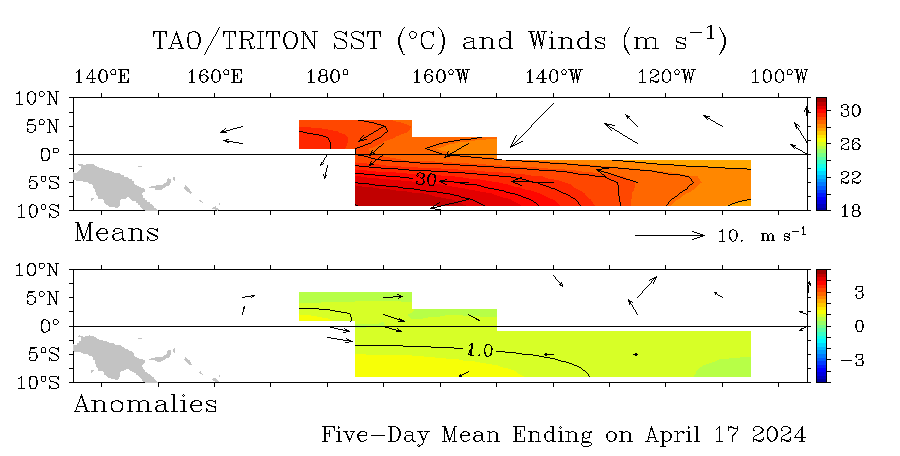
Equatorial sea-surface temperatures are currently more than 1°C above normal in the eastern Pacific, while the Southern Oscillation Index (SOI) remains below zero at around −2, says BOM.
A sustained negative SOI is often associated with El Nino conditions.
BOM hopes to provide a clear picture of the situation in the Pacific by next week when their final June data are analyzed.
El Niño events are usually (but not always) associated with below normal rainfall in the second half of the year across large parts of southern and inland eastern Australia.
Another adverse sign for southeastern Australian rainfall is the recent trend to positive values in the Indian Ocean Dipole (IOD), as measured by the Dipole Mode Index (DMI).
The next BOM update is available on July 8, 2009.
Last month FEWW reported US Climate Prediction Center as saying that conditions were favorable for a transition from ENSO-neutral to El Niño conditions during June – August 2009.

Click image to update and enlarge.

Images from Tropical Atmospheric Ocean project: NOAA
Summary of BOM Weekly Update:
- The Pacific Ocean sea surface is currently significantly warmer than the long-term average across most of the tropical Pacific, especially central to eastern areas.
- A large amount of the sub-surface water of the tropical Pacific is also warmer than the long-term average, particularly in the east.
- The latest 30-day SOI value is −2, while the monthly value for May was −5.
- Trade winds remain weaker than normal across the central equatorial Pacific.
- Cloudiness near the date-line is near-normal, and is yet to show a consistent trend towards El Niño conditions.
- All international climate models predict the tropical Pacific to continue to warm and to be above El Niño thresholds throughout most of the second half of 2009.
“Australia is the world’s fourth-largest wheat exporter and its grain production is still recovering from the worst drought in more than 100 years that reduced the 2006/07 crop to just 10.6 million tonnes and the 2007/08 crop to 13.0 million tonnes.” Reuters reported.
FEWW Moderators estimate that a new episode of El Niño, which would have devastating impact globally, could cause up to $500 billion in damages.
Related Links:
See also comments section for latest updates.

feww said
El Niño Update – 20 July 2009
El Niño Update # 1 [14 July 2009]
El Niño conditions is in progress —NOAA [10 July 2009]
feww said
El Nino seems all but certain: Australia
Wed Jul 1, 2009 5:02am EDT
By Bruce Hextall and Michael Perry
SYDNEY (Reuters) – An El Nino weather pattern this year appears almost certain, Australia’s Bureau of Meteorology said on Wednesday in a revised forecast, raising the prospect of drought in Australia and a even weaker monsoon in India.
The odds for El Nino, an abnormal warming of the eastern Pacific Ocean that creates havoc in weather patterns across the Asia-Pacific region, had risen significantly since two weeks ago, when the bureau said there was a more than 50 percent chance.
“El Nino is a little bit like recession, you are in it before you can say you have one. If it continues as it is now, the historians will say the El Nino started in May,” said David Jones, head of the bureau’s climate analysis, told Reuters.
He said they could declare a full El Nino within weeks.
That’s probably bad news for farmers in Australia who have sown near record acreage, and in India, which is already bracing for below-average monsoon rains, the lifeblood of the country’s agriculture.
It would also have implications for commodity markets, potentially lifting wheat prices that have slumped over the past month on expectations of a bumper global harvest, and adding further fuel to soaring sugar prices that are already bracing for a second disappointing crop year from top consumer India.
Most of Australia’s 2009/10 wheat crop has been planted following plentiful rain, leading to forecasts of a harvest of as much as 23 million tonnes, the best since 2005/06 when 25.2 million tonnes were harvested.
“The growers I speak to say if we were to get some rains in spring we could get above average yields. But if the El Nino forecast materialized, we are again at risk of having a sub-standard crop,” said Richard Koch, managing director of farm advisory firm Profarmer.
Australia’s grain production is still recovering from the worst drought in more than 100 years that cut the annual wheat harvest to as little as 10.6 million tonnes in 2006/07.
India’s weather office last week cut its forecast for the June-September monsoon rains by 3 percentage points to 93 percent of normal, after four years of above average rainfall. From June 1 to June 24 rains were 54 percent below normal.
A severe El Nino spawns searing drought in countries in southeast Asia, harming rubber production, while causing heavy flooding in Peru, Ecuador and Chile, among others.
LITTLE CHANCE OF AVOIDING EL NINO
The bureau’s latest report found that the eastern Pacific Ocean was continuing to warm, with sea temperatures one degree Celsius above normal, and trade winds were continuing to weaken.
The Southern Oscillation Index (SOI), calculated from monthly and seasonal fluctuations in air pressure between Tahiti and Darwin, remained at around negative 2, while the monthly value for May was negative 5.
A sustained negative SOI often indicates El Nino.
“A more complete picture of the situation in the Pacific will be available next week when the final June indices are calculated,” said the report on http://www.bom.gov.au/climate/enso/
The next report is due on July 8.
The Climate Prediction Center in the United States said in June that conditions were favorable for a switch to El Nino conditions during June to August. (Editing by Michael Urquhart)
© Thomson Reuters 2009 All rights reserved