Magnitude 4.2 Quake Strikes W. Montana
Posted by feww on March 6, 2009
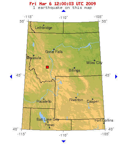
A Magnitude 4.2 Quake Strikes Western Montana Northwest of Yellowstone Plateau volcanic field
A Magnitude 4.2 earthquake struck western Montana Friday about 193 km (120 miles) northwest of Yellowstone Plateau volcanic field. A 2.2 Mw aftershock followed about 4 minutes later.
Additional seismicity of comparable magnitude may prove significant for Yellowstone volcano.
10-degree Map Centered at 45°N,110°W

Source: USGS
This Quake: Magnitude 4.2 – WESTERN MONTANA
Date-Time:
- Friday, March 06, 2009 at 11:29:55 UTC
- Friday, March 06, 2009 at 04:29:55 AM at epicenter
Location: 45.843°N, 112.132°W
Depth: 5 km (3.1 miles) set by location program
Region: WESTERN MONTANA
Distances:
- 4 km (2 miles) SW (221°) from Whitehall, MT
- 14 km (8 miles) W (260°) from Cardwell, MT
- 31 km (19 miles) WNW (300°) from Harrison, MT
- 408 km (254 miles) NE (51°) from Boise, ID
- 566 km (352 miles) N (358°) from Salt Lake City, UT
Location Uncertainty: horizontal +/- 4.2 km (2.6 miles); depth fixed by location program
Parameters NST= 52, Nph= 52, Dmin=24.5 km, Rmss=1.53 sec, Gp= 47°,
M-type=local magnitude (ML), Version=6
Source: USGS NEIC (WDCS-D)
Event ID: us2009dwa1
Information from Yellowstone Volcano Observatory
YELLOWSTONE VOLCANO (CAVW#1205-01-)
- 44.43°N 110.67°W,
- Summit Elevation 9203 ft (2805 m)
- Volcanic Alert Level: NORMAL
- Aviation Color Code: GREEN

An eruption of Old Faithful, perhaps the world’s best known geyser, rises above Yellowstone’s Upper Geyser Basin. Old Faithful is a periodic geyser, with eruptions to heights of about 40 m at intervals of 30 to 100 minutes. Old Faithful Lodge to the right provides a rustic backdrop to the Upper Geyser Basin, which contains more geysers than are known altogether in the rest of the world. The forested ridge in the background is underlain by massive post-caldera rhyolitic lava flows of the Madison Plateau. Photo by Lee Siebert, 1968 (Smithsonian Institution). Caption: GVP
Current Update, last updated Mar 3, 2009 05:33 MST:
February 2009 Yellowstone Seismicity Summary (Source: YVO)
During the month of February 2009, 51 earthquakes were located in the Yellowstone region. The largest event was a magnitude 2.1 on February 19 at 5:02 PM MST, located about 2 miles north of Fishing Bridge, YNP. There were no swarms during the month of February. Earthquake activity in the Yellowstone region is at relatively normal background levels.
An article on the recent earthquake swarm during December 2008 and January 2009 can be found at:
http://volcanoes.usgs.gov/yvo/publications/2009/09swarm.php
Scientists continue to look at data collected during the swarm and will publish their results over the coming months and years. However, if any findings have direct implications for public safety, they will be released to the public immediately.
Ground Deformation Summary: Through January 2009, continuous GPS data show that much of the Yellowstone caldera continued moving upward, though at a lower rate than the past several years. The WLWY station, located in the northeastern part of the caldera has undergone ~22 cm of uplift over this time period. The general uplift of the Yellowstone caldera is of scientific importance and will continue to be monitored closely by YVO staff.
An article on the current uplift episode at Yellowstone and discussion of long-term ground deformation at Yellowstone and elsewhere can be found at: http://volcanoes.usgs.gov/yvo/publications/2007/upsanddowns.php
Recent Earthquakes in the Intermountain West:
Yellowstone National Park Special Map

Source: University of Utah Seismograph Stations

Volcanic History Overview (Source: YVO)
The Yellowstone Plateau volcanic field developed through three volcanic cycles spanning two million years that included some of the world’s largest known eruptions. Eruption of the >2450 cu km Huckleberry Ridge Tuff about 2.1 million years ago created the more than 75-km-long Island Park caldera. The second cycle concluded with the eruption of the Mesa Falls Tuff around 1.3 million years ago, forming the 16-km-wide Henrys Fork caldera at the western end of the first caldera. Activity subsequently shifted to the present Yellowstone Plateau and culminated 640,000 years ago with the eruption of the >1000 cu km Lava Creek Tuff and the formation of the present 45 x 85 km caldera. Resurgent doming subsequently occurred at both the NE and SW sides of the caldera and voluminous (1000 cu km) intracaldera rhyolitic lava flows were erupted between 150,000 and 70,000 years ago. No magmatic eruptions have occurred since the late Pleistocene, but large phreatic eruptions took place near Yellowstone Lake during the Holocene. Yellowstone is presently the site of one of the world’s largest hydrothermal systems including Earth’s largest concentration of geysers. (Source: YVO)

feww said
UPDATE:
Magnitude 3.5 quake struck WYOMING
Date-Time:
* Saturday, March 07, 2009 at 02:45:10 UTC
* Friday, March 06, 2009 at 07:45:10 PM at epicenter
Location: 41.670°N, 109.923°W
Depth: 4.5 km (2.8 miles)
Region: WYOMING
Distances:
* 9 km (6 miles) NNE (23°) from Granger, WY
* 15 km (9 miles) NNW (343°) from Little America, WY
* 35 km (22 miles) ESE (108°) from Opal, WY
* 194 km (120 miles) ENE (58°) from Salt Lake City, UT
Location Uncertainty: horizontal +/- 0.6 km (0.4 miles); depth +/- 1.7 km (1.1 miles)
Parameters: Nph= 13, Dmin=29.6 km, Rmss=0.22 sec, Gp= 61°,
M-type=local magnitude (ML), Version=3
Source: University of Utah Seismograph Stations (via USGS)
Event ID: uu00003280
Historic Earthquakes Wyoming
* 1959 08 18 – Wyoming – M 6.5
* 1975 06 30 – Yellowstone National Park, Wyoming – M 6.1
* 1995 02 03 – Wyoming – M 5.3 (Fatalities 1)
* 2002 10 22 – Alpine Northeast, Wyoming – M 4.2
* 2003 08 21 – Wyoming – M 4.5
* 2004 01 07 – Wyoming – M 5.0
* 2004 04 07 – Wyoming – M 4.0
* 2004 08 29 – Wyoming – M 3.8
Source: http://earthquake.usgs.gov/regional/states/historical_state.php#wyoming