
TC Laurence Intensifies to 167 km Sustained Winds
Active Tropical Cyclone in Southern Hemisphere
- Date Time: December 16 09:00 UTC
- Approximate Position: 16.3ºS, 124.2ºE
- Location: Located approximately 440 nmi northeast of Port Hedland, Australia
- Movement: Has been tracking 185 degrees at 08 knots during the past six hours.
- Max Sustained Winds: 075 knots, Gusts 090 knots [compared with winds of 35 kt and gusts of 45 kt 48 hrs ago; and 075 kt, 24 hors ago]
- Max Significant Wave Heights: Laurence is now located over land.
Based on the current forecast track, the system is now expected to move further inland and dissipate within the next 60- 72 hours. ALL but two models agree.

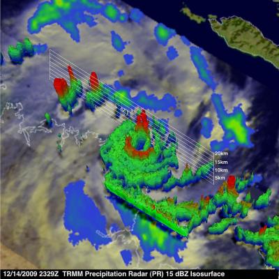
Top Left: NASA’s Tropical Rainfall Measuring Mission (TRMM) satellite captured this image of Laurence’s rainfall on Dec. 14 at 5:29 p.m. ET (2329 UTC). TRMM revealed a well defined center of circulation in Laurence with areas of heavy rain (red) up to 2 inches per hour. Credit: NASA/SSAI, Hal Pierce
Top Right: NASA Tropical Rainfall Measuring Mission (TRMM) satellite 3-D image shows thunderstorm tops reaching about 9.3 miles high in various sides of Cyclone Laurence (red). The red areas also indicate rainfall at about 2 inches per hour. Credit: Hal Pierce.


Severe Tropical Cyclone Laurence. AUSTRALIAN GOVERNMENT BUREAU OF METEOROLOGY/ TROPICAL CYCLONE WARNING CENTRE PERTH/ TROPICAL CYCLONE FORECAST TRACK MAP/ Issued at 2:41 pm WST Wednesday 16 December 2009. Image may be subject to copyright. Click on images to enlarge.
Remarks by BOM:
- Severe Tropical Cyclone Laurence is a small but very intense tropical cyclone having VERY DESTRUCTIVE WINDS with gusts to 260 km/h .
- Laurence is expected to weaken overnight IF it moves in a generally southerly direction towards Derby.
- HEAVY RAIN is expected to continue over the north and west Kimberley. Daily rainfall totals in excess of 100mm are possible near the coast with totals decreasing further inland.
Related Links:
