Recent Volcanic Activity – Satellite Images
Posted by feww on June 11, 2010
Plume Spewed by Ulawun Volcano
Ulawun Volcano located on Papua New Guinea (PNG) island of New Britain spewed a plume of steam and ash on June 10, 2010. The above is a natural-color image captured by ALIon NASA’s EO-1 satellite on the same day.

Ulawun is one of the most active volcanoes in PNG and has repeatedly erupted producing large lava and pyroclastic flows over the past 40 years. Image Source: NASA E/O. Click images to enlarge.
Ulawun Volcano (Father) and Bamus Volcano (Son)
Summit Elevation: 2,334 m
Coordinates: 5.05°S, 151.33°E

Ulawun and Bamus volcano (upper left) are the two highest volcanoes of the Bismarck arc, and are known as the Father and South Son volcanoes. The peak to the left of the summit is a prominent E-W-trending escarpment on the south side that may result from large-scale slumping. Historical eruptions date back to the beginning of the 18th century. Photo by Wally Johnson (Australia Bureau of Mineral Resources). Caption: GVP.
Klyuchevskaya Volcano Signals New Round of Activity

Protruding from clouds, the summit of Klyuchevskaya Volcano located on Kamchatka Peninsula (Russia) released a small plume on June 7, 2010. Natural-color image acquired by ALI on NASA’s EO-1Download large image (924 KB, JPEG) satellite the same day. “A faint brown-gray plume blows toward the north (image right), contrasting with the bright clouds below.” Source: NASA E/O.
6,000-year-old Kliuchevskoi: Kamchatka’s highest and most active volcano
Summit Elevation: 4,835m
Coordinates: 56.057°N, 160.638°E

The 4,835-m-high basaltic stratovolcano has produced frequent moderate-volume explosive and effusive eruptions without major periods of inactivity. More than 100 flank eruptions have occurred during the past roughly 3,000 years, with most lateral craters and cones occurring on the NE (seen here) and SE flanks of the conical volcano at altitudes of 500-3,600 m. Photo by E.Y. Zhdanova (courtesy of Oleg Volynets, Institute of Volcanology, Petropavlovsk). Source: GVP.
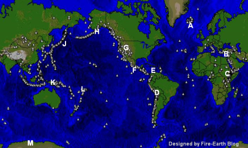
Grouping on the Global Map
- Ulawun, New Britain [Group K]
- Kliuchevskoi, Central Kamchatka (Russia) [Group J]
Map of Volcanoes

Map of Volcanoes. Background Map: University of Michigan. Designed and enhanced by Fire Earth Blog. Click image to enlarge.
Latest Entries:
Related Links:
More Links:
- A New Era of Intense Volcanic Unrest May Have Begun
- Tonga’s Metis Shoal may be erupting
- Rumble III Volcano “blew its top!”
FEWW Volcanic Activity Forecast
- Sumatra’s Mt Kerinci Erupts
- Volcano Watch Weekly: 23 April 2009
- Weekly Volcano Watch: 16 April 2009
- Weekly Volcano Watch: 2 April 2009
Other Related Links:

Leave a comment