Fire Earth

Earth is fighting to stay alive. Mass dieoffs, triggered by anthropogenic assault and fallout of planetary defense systems offsetting the impact, could begin anytime!

Posts Tagged ‘The Largest Earthquake’

Disaster Update: Indonesia Quake

Posted by feww on October 1, 2009

Indonesia Quake, Typhoon Ketsana and Samoa Tsunami

The death toll from the powerful earthquake in southern Sumatra, Indonesia has reached about 200, but is likely to rise sharply.

sumatra quake
Students walk out from a collapsed building after an earthquake hit Padang, on Indonesia’s Sumatra island September 30, 2009. REUTERS/Muhammad Fitrah/Singgalang Newspaper

Let’s be clear about this. The quake that hit Padang, Sumatra, was much stronger than reported. It was at least a magnitude 7.8, about 3 times stronger than reported.

Some high-rise buildings in Singapore, about 450 km northeast of the epicenter felt the tremors, which also shook some office buildings in  Kuala Lumpur, Malaysia.

Indonesia’s Vice President Jusuf Kalla confirmed late last night that in Jakarta, that the death toll would rise because there was substantial damage in the area with many buildings  collapsed.

Based on the information received and experience from the previous events, FEWW Moderators believe that the death toll might be as high as 2 – 3,000, with many more number of injuries.

“The big buildings are down. The concrete buildings are all down, the hospitals, the main markets, down and burned. A lot of people died in there. A lot of places are burning,” Australian businesswoman  in Padang told Australian radio.

“Most of the damage is in the town center in the big buildings. The little houses, the people’s houses, there are a few damaged, but nothing dramatic. It’s not all a rubble heap in terms of smaller buildings.”

“The quake was followed by a very heavy rain. Many houses and some building are flattened in my area. But I cannot yet verify too much. We will try to compile the data and distribute aid once the rain subsides,” the district mayor of Pariaman District, one of the worst hit areas told reporters.

“A number of hotels in Padang have been destroyed,” Rahmat Triyono, an  employee of the Indonesian geophysics and meteorology agency, told AFP.

“Up to now we haven’t been able to reach Padang, communications have been cut,” he added.

An eye-witness reportedly told Reuters that there was “extreme panic” in the city, with bridges collapsing,  and water from broken pipes causing flooding.

Related Links:

Posted in extreme panic, Indonesia quake, pandang quake, Pariaman District, sumatra earthquake | Tagged: , , , , , | 1 Comment »

Magnitude 8.3 Quake Strikes Samoa Islands Region

Posted by feww on September 29, 2009

Up to 3 More Large EQs Could Strike the Pacific Ring of Fire in 2009

The Next Megaquake May Strike New Zealand

Massive Earthquake Measuring up to 8.4 Mw Strikes Samoa Islands Region

The mainshock occurred on Tuesday, September 29, 2009 at 17:48 UTC [Tuesday, September 29, 2009 at 06:48 AM at epicenter,] which struck at striking at a depth of about 10km.  The mainshock has since been  followed by at least two dozen aftershocks both locally and in the neighboring Tonga region, the largest of which measures 6.2 Mw so far.

Tsunami

The large earthquake generated  1.6-meter  waves in American Samoa, Apia and Pago Pago. The Pacific Tsunami Warning Center (NOAA/NWS/PTWC) issued a tsunami warning which has since been canceled.

According to local news, at least 4 villages were wiped off, leaving more than 40 dead and up to a 100 injured. Most of the casualties are believe to be children. More casualties are expected as local reports are received.

How large was this earthquake?

The GFZ Potsdam – Earthquake Bulletin reported the mainshock as M 8.2, while the European-Mediterranean Seismological Center recorded it as 8.1Mw. However, FEWW believes the quake measured up to 8.4Mw.

On June 26, 1917, a magnitude 8.4 earthquake struck the neighboring Tonga region at a depth of about 25km, some 115 km northwest of today’s event.

Tsunami Location Map


Click on image to enlarge
. Source NOAA

This advisory is in effect for California, and Oregon

  • A tsunami advisory indicates a tsunami which may produce strong currents and is dangerous to those in or very near the water is expected.
  • Large inundations are not expected in areas under advisory status.
  • Advisories will be cancelled, extended, or upgraded to a warning depending on the event severity.
  • Advisories are issued when the expected tsunami amplitude is in the range of 0.3 to 1 meter.

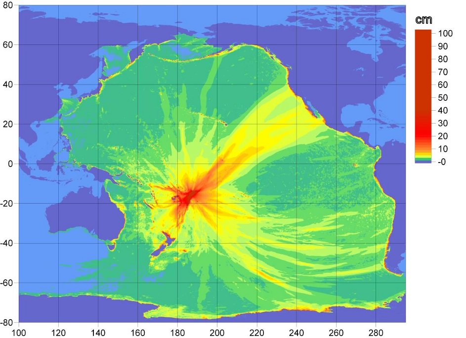
Tsunami Propagation Map


Click on image to enlarge.
Source: NOAA/WCATWC

US Tsunami waves initial arrival times

tsunami trvel time table
Tsunami waves initial arrival times including wave amplitude above sea level (ASL) at the US coastal areas.


Click  on image to enlarge. Source NOAA

Tsunami Travel Time Map

tsunami trvel time
Tsunami Travel Time Map. Source NOAA/NGDC. Click on image to enlarge.

Map of Tsunami Advisory – Japan

JMA sunami advisory
Map of Tsunami Advisory  for  Japan. Yellow highlights indicate tsunami heights of about 0.5m (50cm). Original Map: Japan Meteorological Agency (JMA). Image may be subject to copyright. Click on image to enlarge.

Earthquake Details

GFZ Potsdam – Earthquake Bulletin
Region: Samoa Islands Region
Time: 2009-09-29 17:48:10.3 UTC
Magnitude: 8.2
Epicenter: 172.04°W 15.49°S
Depth: 10 km
Status: manually revised

Samoa Island Region gfz2009tceh
© Helmholtz-Zentrum Potsdam Deutsches GeoForschungsZentrum – GFZ

USGS downgraded the mainshock to 8.0Mw.

10-degree Map Centered at 15°S,170°W

Samoan Islands USGS
Earthquake Location Map. Original Map: USGS. Enhanced by FEWW.

Historic Seismicity (Mag 7 or greater EQs since 1900)

hiseis samoan Islands quake 29-09-09
Major Tectonic Boundaries: Subduction Zones -purple, Ridges -red and Transform Faults -green

Original Image: USGS. Enhanced by FEWW.

Related Links:

Posted in APIA quake, APIA tsunami, Earthquakes, Hihifo quake, NUKUALOFA, tsunami hazard | Tagged: , , , , , , , , , | 8 Comments »