Fire Earth

Earth is fighting to stay alive. Mass dieoffs, triggered by anthropogenic assault and fallout of planetary defense systems offsetting the impact, could begin anytime!

Archive for August 13th, 2009

Northern India’s Groundwater is Rapidly Depleting

Posted by feww on August 13, 2009

India’s aquifer depletion poses serious threats in  potable water supplies, farming and food production.

A new study by a team of hydrologists, led by NASA’s Matt Rodell,  says Northern India’s water level is plunging because water is being pumped and consumed faster than the aquifers can be recharged naturally. Their research — published in the August 20 issue of Nature — uses data from NASA’s Gravity Recovery and Climate Experiment (GRACE).


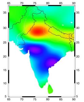
The map shows groundwater changes in India during 2002-08, with losses in red and gains in blue, based on GRACE satellite observations. The estimated rate of depletion of groundwater in northwestern India is 4.0 centimeters of water per year, equivalent to a water table decline of 33 centimeters per year. Increases in groundwater in southern India are due to recent above-average rainfall, whereas rain in northwestern India was close to normal during the study period. Credit: I. Velicogna/UC Irvine.
Source: NASA Earth Science News.

“If measures are not taken to ensure sustainable groundwater usage, consequences for the 114 million residents of the region may include a collapse of agricultural output and severe shortages of potable water,” said Rodell.

For more details, see original entry: India faces severe water, farming, food crisis

Related Links:

Posted in Climate Change, first wave of collapsing cities, global water crisis, iindia water scarcity, India food security | Tagged: , , , , | Leave a Comment »

3rd Powerful Quake in 3 Days Strikes Japan Region

Posted by feww on August 13, 2009

More Powerful Quakes May Strike Region:FEWW

Magnitude 6.7 Mw the third significant quake to strike Japan region in three days

Another powerful earthquake measuring 6.7Mw occurred about 60km ESE of Hachijo-jima, Izu Islands, Japan Region, USGS reported, striking at a depth of 51 km at 22:48:51 UTC on Wednesday.

A moderate aftershock measuring 4.7 reportedly occurred about three hours later, on Thursday, August 13, 2009 at 01:53:06 UTC [USGS Event ID: us2009kgad.]  See smaller square in red superimposed on the mainshock marked in orange.

10-degree Map Centered at 35°N,140°E

us2009kfcp
Earthquake Location Map. Source: USGS

This Earthquake

  • Magnitude: 6.7
  • Date-Time:
    • Wednesday, August 12, 2009 at 22:48:51 UTC
    • Thursday, August 13, 2009 at 07:48:51 AM at epicenter
  • Location: 32.816°N, 140.382°E
  • Depth: 51 km (31.7 miles) set by location program
  • Region: IZU ISLANDS, JAPAN REGION
  • Distances:
    • 60 km (40 miles) ESE of Hachijo-jima, Izu Islands, Japan
    • 300 km (190 miles) SE of Shizuoka, Honshu, Japan
    • 320 km (200 miles) S of TOKYO, Japan
    • 325 km (200 miles) SE of Hamamatsu, Honshu, Japan
  • Location Uncertainty:  horizontal +/- 5.6 km (3.5 miles); depth fixed by location program
  • Parameters:  NST=156, Nph=156, Dmin=>999 km, Rmss=1 sec, Gp= 58°, M-type=teleseismic moment magnitude (Mw), Version=8
  • Source: USGS NEIC (WDCS-D)
  • Event ID: us2009kfcp

This earthquake was the third significant seismic event to strike Japan region in just over 72 hours.

1. A powerful earthquake measuring 7.1Mw struck about 165km W of Hachijo-jima, Izu Islands, Japan, at a depth of 303.1km at on August 9, 2009 at 10:55:56 UTC. [EQ No 1 on the location map below.]

2. A strong earthquake measuring 6.4 occurred about 30km SSW of Shizuoka, Japan, at a depth of 30km at 20:07:07 UTC on Monday, August 10, 2009. [No 2 on the location map below.]

3. A 3rd earthquake [this report] measuring 6.7 occurred about 60km ESE of Hachijo-jima, Izu Islands, Japan region at a depth of 51 km at 22:48:51 UTC on August 12, 2009. [No 3 on the location map below.]

Location map japan quakes
Location map of the three significant earthquakes that struck Japan between 9 and 12 August 2009. Original Map: USGS

Earthquake Location Maps [USGS]

neic_kfcp_cy  izu  12aug 2009

neic_kfcp -  izu  12aug 2009 zoom in
Major Tectonic Boundaries: Subduction Zones -purple, Ridges -red and Transform Faults -green [Source: USGS]

Seismic Hazard Map
neic_kfcp_w  izu
Major Tectonic Boundaries: Subduction Zones -purple, Ridges -red and Transform Faults -green [Source: USGS]

Historic Seismicity
us2009kcaz izu HisSeis
Major Tectonic Boundaries: Subduction Zones -purple, Ridges -red and Transform Faults -green [Source: USGS]

Tsunami Information

Japan Meteorological Agency reported NO tsunami damage by this earthquake, but said there may be slight sea level changes in the region.

Related Links:

Posted in 3rd Japan Quake, earthquake forecast, Hachijo-jima, seismic event report, Shizuoka | Tagged: , , , , | 3 Comments »