
Country in Focus: Bangladesh

Satellite image of Bangladesh (Photo credit NASA)
Geography
- Land Area: 136,000 km² (US comparative: slightly smaller than Iowa)
[Global rank by area: 94th] - Water 10,325 km²
- Coastline: 580 km
Elevation extremes
- Lowest point: Indian Ocean 0 m
- Highest point: Peak, the Mowdok range, 1052m
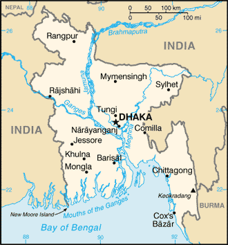
Most of the country is situated on deltas of large rivers flowing from the Himalayas: the Ganges unites with the Jamuna (main channel of the Brahmaputra) and later joins the Meghna to eventually empty into the Bay of Bengal (Source: CIA, The World Factbook)
Land use
- Arable land: 55.39%
- Permanent crops: 3.08%
- Other: 41.53% (2005)
Map of Bangladesh (Source: CIA, The World Factbook)
Population
- 2007 Estimate: 150,448,340
[Global Rank by population: 7th] - Density: 1106/km²
[Global Rank by population: 11th] - The population of Bangladesh rose from 75 million in 1971, to more than 150 million in 2007.
- The population is still growing at an annual rate of about 2 percent.
Environmental issues
many people are landless and forced to live on and cultivate flood-prone land; water-borne diseases prevalent in surface water; water pollution, especially of fishing areas, results from the use of commercial pesticides; ground water contaminated by naturally occurring arsenic; intermittent water shortages because of falling water tables in the northern and central parts of the country; soil degradation and erosion; deforestation; severe overpopulation (Source: CIA, The World Factbook)
- About 10 million people are threatened by annual floods and storms.
- About 4,500 people were killed and at least two million were made homeless homeless as a result of two massive floods and a cyclone in 2007.
- Extreme climate events destroyed about 2 million tonnes of rice, the country’s main staple, in 2007.

Ganges River Delta, Bangladesh and India (Image: NASA)
Bangladesh is threatened by
- Climate Change
- Rising population
- Shrinking farmland


3/4 of Dhaka, the capital of Bangladesh, under water (2004)
Bangladeshi Children and adults move through flood stricken areas.
[Photo Credit: University of Alabama]
Related Links:
