WE TOLD YOU SO!
Strong Quake Rattles New Zealand’s Proposed Oil Drilling Site at Raukumara Basin
On April 15, 2011 FIRE-EARTH said
Ironically, Raukumara Basin sits between Kermadec Trench and Kermadec Ridge, and has an inherently unstable geology. FIRE-EARTH believes any oil-drilling in the exceptionally seismic area would most certainly prove disastrous for the entire region.
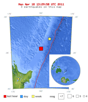
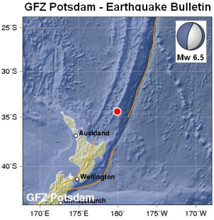
The quake struck at a depth of 90 km about 550 km ENE of Auckland, New Zealand.
10-degree Map Centered at 35°S,180°E

Earthquake Location Map. Source: USGS. Map enhanced by FIRE-EARTH
Earthquake Details [USGS]
- Magnitude: 6.6
- Date-Time: Monday, April 18, 2011 at 13:03:04 UTC [Tuesday, April 19, 2011 at 01:03:04 AM at epicenter]
- Location: 34.321°S, 179.994°E
- Depth: 90.4 km (56.2 miles)
- Region: SOUTH OF THE KERMADEC ISLANDS [NNE of East Cape, New Zealand]
- Distances:
- 380 km NNE (21°) of East Cape New Zealand [FIRE-EARTH estimate]
- 551 km (342 miles) ENE (61°) from Auckland, New Zealand
- 899 km (559 miles) NNE (32°) from WELLINGTON, New Zealand
- Location Uncertainty: horizontal +/- 14.1 km (8.8 miles); depth +/- 5.4 km (3.4 miles)
- Parameters: NST=460, Nph=487, Dmin=390.7 km, Rmss=1.26 sec, Gp= 14°, M-type=teleseismic moment magnitude (Mw), Version=E
- Source: U.S. Geological Survey, National Earthquake Information Center: World Data Center for Seismology, Denver
- Event ID: usc0002ty7
In Navy Vessel Used Against Deep Sea Drilling Protesters Posted on April 15, 2011 FIRE-EARTH said:

The 25,000sqkm Raukumara Basin extends about 300km north of East Cape. Source NZ gov.
License to Pollute
Without consulting the local Maori, New Zealand government granted Petrobras a five-year permit for exploration of the Raukumara Basin, off the East Cape of New Zealand in June 2010.
Local Maori feel the pollution risk to the water and fish stocks in the regions is too great, should oil be found off the East Cape of New Zealand.
Ironically, Raukumara Basin sits between Kermadec Trench and Kermadec Ridge, and has an inherently unstable geology. FIRE-EARTH believes any oil-drilling in the exceptionally seismic area would most certainly prove disastrous for the entire region. See blog content for New Zealand earthquake forecasts.

