
Iraq Ecocide Nears Totality
Posted by feww on August 1, 2009
See also entry at EDRO:
Iraq Faces Environmental Catastrophe
Once a fertile land, Iraq is being desertified
Iraq is now entering its third year of drought, with no relief in sight. Wells, marshes and riverbeds are drying up, “turning arable land into desert, killing trees and plants, and generally transforming what was once the region’s most fertile area into a wasteland.” EDRO Wrote.
Nearly 30 years of war and occupation is finally taking its toll. As the drought [official corruption,] and mismanagement of land continue, the frequency and extent of sandstorms rise as if proportionally. The storms have become longer-lasting.
Drinking water shortages has plagued much of southern Iraq. “The fabled marshes of southern Iraq, drained by Saddam Hussein and then re-flooded after the U.S.-led invasion in 2003, are drying up, and the traditional Marsh Arabs who depend on them for their livelihood are being forced to leave again.”
The Ministry of Agriculture reported that 90% of the land has either turned to desert or is experiencing severe desertification, with the remaining arable land eroding at an annual rate of 5%, LATimes reported.
Falling agricultural production means that Iraq, once a food exporter, will this year have to import nearly 80% of its food, spending money that is urgently needed for reconstruction projects.
EDRO said:
Plagued by frequent dust storms, Iraq is being transformed from a fertile country to a dust bowl. Man-made disasters drive Iraq to the verge of ecological collapse.War of occupation and the near total destruction of infrastructure, drought and water shortages, desertification and sandstorms, collective ignorance and pathological violence, fear and political corruption and mismanagement of resources are accelerating the pace of destruction in Iraq, hastening the collapse of local and regional ecosystems.

A composite view of the Mesopotamian marshlands from a mosaic of four Landsat 1 images and two false-color, near-infrared images, 1973–1976. Dense marsh vegetation (mainly Phragmites australis) appears in dark red, seasonal lakes in blue, agriculture in pink, and permanent lakes in black. The red elongated patches along riverbanks are date palms. The three main marsh areas are Al-Hawizeh, Central, and Al-Hammar, labeled 1, 2, and 3, respectively. The city of Basrah is located at number 4.Modified from Richardson and colleagues (2005). (b) A Landsat 7 Enhanced Thematic Mapper mosaic taken in 2000. Most of the drained marshes appear as grayish-brown patches, indicating dead marsh vegetation or low desert shrubs and dry ground. The white and gray patches indicate bare areas with no vegetation and, in some areas, salt evaporites or shells covering the bottoms of former lakes. By 2000, 85% of the 8926 square kilometers (km2) of permanent marsh in 1973 marshlands had been destroyed. Only 3% of the Central marsh and 14.5% of the Al-Hammar remained. Sampling sites: A, Al-Hawizeh; B, Central; C, Al-Hammar; D, Al-Sanaf; E, Abu Zarag; F, Suq Al-Shuyukh. MODIS satellite image courtesy of the United Nations Environment Programme, Iraq Marshlands Observation System. Image and caption source: Restoring the Garden of Eden: An Ecological Assessment of the Marshes of Iraq (pdf).
Iraq Dust Storms
Beginning in mid April, and continuing through may, and June dust storms plagued Iraq. In late June/early July 2009, the worst dust storm in living memory struck Iraq, spreading throughout the region, NASA EO reported. A new storm lashed Iraq again at the end of July.
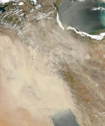
Sandstorms in Iraq

Since the turn of the twenty-first century, the frequency and duration of such storms have increased. Beginning in late June 2009, the worst dust storm in living memory struck Iraq and spread to neighboring countries. Another storm raged over Iraq again at the end of July. The Moderate Resolution Imaging Spectroradiometer (MODIS) on NASA’s Aqua satellite captured this true-color image of Iraq on July 30, 2009, the second consecutive day of heavy dust over the country. Thick dust blows southeastward over the Tigris and Euphrates floodplain and the Persian Gulf. The dust is thick enough to completely hide the land surface and water bodies below.
NASA image by Jeff Schmaltz, MODIS Rapid Response Team, Goddard Space Flight Center. Caption by Michon Scott. [Edited by FEWW]
Related Links:
- Iraq Faces Environmental Catastrophe
- First Wave of World’s Collapsing Cities
- Future Scenarios
- Nuking Earth for Lifestyle
- The Fate of Energy Dinosaurs
- Energy: 286W
- Failing Ecosystems
- Image of the Day: Sandstorm in Saudi Desert
- Drought and Deluge
- CO2e Links Page
- World CO2 Emissions
- Carbon Footprint of Your Dollar
- New York Cognitive Dissonance
- World Problems: The Root Cause Matrix
- Giga Trends
- Look me straight in the eye & tell me you can’t
- Protect Economy from Climate??!
- Blind scientists examining the economic elephant
- How Much Carbon Dioxide Does Your Money Make?
- Cosmic Scale Evil
Other Related Links:

Leave a comment