Fire Earth

Earth is fighting to stay alive. Mass dieoffs, triggered by anthropogenic assault and fallout of planetary defense systems offsetting the impact, could begin anytime!

Posts Tagged ‘desertification’

Drought Affects nearly One Billion Trees in California

Posted by feww on December 31, 2015

Ecological catastrophe: 29 million trees dead, 58 million more on the brink

New research by a Carnegie research team has revealed that up to 58 million large trees in California has experienced “severe canopy water loss between 2011 and today due to the state’s historic drought.”

The U.S. Forest Service says more than 29 million trees in California forests have already died.

“In addition to the persistently low rainfall, high temperatures and outbreaks of the destructive bark beetle increased forest mortality risk.”

The team used laser-guided imaging spectroscopy tools that are mounted on the Carnegie Airborne Observatory (CAO) to measure the full impact of the drought on California’s forests, and combined the CAO data with satellite data starting 2011.

The team’s advanced tools showed that about 41,000 square miles (10.6 million hectares) of forest containing up to 888 million large trees experienced measurable losses of canopy water between 2011 and 2015.  Of this group, up to 58 million large trees reached water loss thresholds that the scientists deemed extremely threatening to long-term forest health.”

Should drought conditions persist, the team concluded, there would be substantial changes to already significantly weakened forest structures and ecosystems in the near future, given the severity of the exiting conditions.


Progressive forest canopy water stress in the state of California from 2011 to 2015. Credit: Greg Asner

Posted in News Alert | Tagged: , , , , , , | Leave a Comment »

Parched West Depleting Underground Water

Posted by feww on July 25, 2014

EXTREME WEATHER & CLIMATIC EVENTS
RISING TEMPERATURES
EXCEPTIONAL DROUGHT
MULTIPLE STATES OF EMERGENCY
MAIN SCENARIOS 900, 800, 555, 444, 123, 111, 101, 100, 033, 011, 08, 04, 03, 02
.

‘We thought that the picture could be pretty bad, but this was shocking’

Researchers say more than 75 percent of the water loss in the drought-stricken Colorado River Basin came from underground resources, starting late 2004.

They are now admitting that the extent of groundwater loss poses a greater threat to the water supply of the western United States than previously thought.

Underground water stores in the West have receded at an alarming rate worsening drought that has scorched multiple states from Oklahoma to the Pacific Coast.

“Monthly measurements in the change in water mass from December 2004 to November 2013 revealed the basin lost nearly 53 million acre feet (65 cubic kilometers) of freshwater. That’s almost double the volume of the nation’s largest reservoir, Nevada’s Lake Mead. More than three-quarters of the total—about 41 million acre feet (50 cubic kilometers)—was from groundwater,” according to the report.

“We don’t know exactly how much groundwater we have left, so we don’t know when we’re going to run out,” said a water resources specialist at the University of California, Irvine.

“This is a lot of water to lose. We thought that the picture could be pretty bad, but this was shocking.”

The Colorado River

The Colorado River is the only major river in the southwestern United States. Its basin supplies water to more than 40 million people in 7 states, and irrigates at least four million acres of farmland.

Most of the reduction has been recorded in the Lower Colorado River Basin.

FIRE-EARTH 2009 Forecast: Desertification of California in the Near Future Is Almost a Certainty – with the critical phase occurring by as early as 2011.

[NOTE: The above forecast and most of the links posted below have previously been filtered/censored by Google, WordPress and rest of the Internet Mafia. Editor]

California State Resources

California Data Exchange Center – Reservoirs

Conditions for 6 Largest Reservoirs: 23-Jul-2014 (Report Generated: 25-Jul-2014 4:06 AM)

Lake Shasta –

  • Current Storage: 1,644,468 AF
  • 36% of Total Capacity
  • 49% of Historical Avg. For This Date
  • (Total Capacity: 4,552,000 AF)
  • (Avg. Storage for Jul 23: 3,341,319 AF)

Lake Oroville –

  • Current Storage: 1,303,267 AF
  • 37% of Total Capacity
  • 49% of Historical Avg. For This Date
  • (Total Capacity: 3,537,577 AF)
  • (Avg. Storage for Jul 24: 2,648,645 AF)

Trinity Lake –

  • Current Storage: 913,231 AF
  • 37% of Total Capacity
  • 46% of Historical Avg. For This Date
  • (Total Capacity: 2,447,650 AF)
  • (Avg. Storage for Jul 23: 1,987,858 AF)

New Melones –

  • Current Storage: 647,861 AF
  • 27% of Total Capacity
  • 44% of Historical Avg. For This Date
  • (Total Capacity: 2,400,000 AF)
  • (Avg. Storage for Jul 23: 1,483,900 AF)

San Luis –

  • Current Storage: 498,632 AF
  • 24% of Total Capacity
  • 46% of Historical Avg. For This Date
  • (Total Capacity: 2,041,000 AF)
  • (Avg. Storage for Jul 23: 1,072,891 AF)

Don Pedro –

  • Current Storage: 926,110 AF
  • 46% of Total Capacity
  • 59% of Historical Avg. For This Date
  • (Total Capacity: 2,030,000 AF)
  • (Avg. Storage for Jul 23: 1,565,879 AF)

California Drought Disasters


Posted in Climate Change, environment, global disasters | Tagged: , , , , , , , | Leave a Comment »

Extreme Drought Spreads in California

Posted by feww on July 25, 2014

EXTREME WEATHER & CLIMATIC EVENTS
RISING TEMPERATURES
EXCEPTIONAL DROUGHT
MULTIPLE STATES OF EMERGENCY
MAIN SCENARIOS 900, 800, 555, 444, 123, 111, 101, 100, 033, 011, 08, 04, 03, 02
.

Exceptional and Extreme Drought Levels Cover about 82 Percent of California

About 81.89 percent of California is covered by ‘Extreme’ to ‘Exceptional’ drought levels, up from 81.85 percent last week.

The entire land area in the Golden State is experiencing ‘Severe’ to Exceptional drought, according to U.S. Drought Monitor.

California experiences record warmest winter and spring

Meanwhile, the most populous U.S. state saw its warmest winter and spring on record this year, with the temperatures rising 2.8ºC (5 degrees Fahrenheit)  above normal during the first six months of 2014,  about 0.6ºC (1 degree F) warmer than the previous record, increasing the threat of water famine, crop disasters and wildfires even further.

FIRE-EARTH 2009 Forecast: Desertification of California in the Near Future Is Almost a Certainty – with the critical phase occurring by as early as 2011.

[NOTE: The above forecast and most of the links posted below have previously been filtered/censored by Google, WordPress and rest of the Internet Mafia. Editor]

California State Resources

California Drought Disasters

Posted in Global Disaster watch, global disasters | Tagged: , , , , , , , , | Leave a Comment »

WE TOLD YOU SO: Golden State Continues Shrinking

Posted by feww on June 21, 2014

EXTREME WEATHER & CLIMATIC EVENTS
EXCEPTIONAL DROUGHT
RISING TEMPERATURES
FISHERY DISASTERS
CROP DISASTERS
MULTIPLE STATES OF EMERGENCY

SCENARIOS 555, 444, 111, 071, 03
.

Exceptional Drought Plagues Third of California

Exceptional Drought spreads to about 33 percent of California, up from 25 percent last week— a jump of 32 percent.

The entire state of California, now in its third year of a catastrophic drought, has been experiencing severe drought or worse for about three months.

20140617_ca_trdsm

“Usually about this time of year we kind of settle into a pattern where it stabilizes and we don’t expect things to change,” said California state climatologist. “But in this case with the severity of the drought we expect to see more impacts come up as the summer progresses.”

FIRE-EARTH 2009 Forecast: Desertification of California in the Near Future Is Almost a Certainty – with the critical phase occurring by as early as 2011.

[NOTE: Congratulations! The above forecast and most of the links posted below have previously been filtered/censored by Google, WordPress and others. Editor]

Related Links

Fishery Disasters

Posted in Climate Change, Global Disaster watch, global disasters | Tagged: , , , , , , , | Leave a Comment »

India, too, is shrinking!

Posted by feww on June 18, 2014

EXTREME WEATHER & CLIMATIC EVENTS
DROUGHT
HUMAN IMPACT
DESERTIFICATION
SCENARIOS 900, 800, 444, 111, 071, 03
.

Nearly 2/3 of India Undergoing Desertification, or Land Degradation

More than a quarter of  India’s total land is undergoing desertification, while over a third is facing degradation that has affected its productivity, critically affecting the livelihood and food security of hundreds of millions people across the country, said a report.

About 105.2 million hectares (Mha), or 35.5% of India’s total land area, is being degraded, while 82.2 Mha, or 27.7%,  is undergoing desertification.

Nearly 70 percent of land in India is dry and therefore prone to drought, making it vulnerable to water and wind erosion, salinization and water logging, according to a 2007 report prepared by Indian Space Research Organization.

Soil erosion accounts for about 72 percent of the total degradation in the country, while wind erosion causes over 10 percent of the damage, said the report. Water-logging and salinity/alkalinity are also responsible for the erosion, according to the latest National Report on Desertification, Land Degradation and Drought.

The worst affected areas are the states of Rajasthan with 23 Mha desrtified, followed by Gujarat, Maharashtra and Jammu and Kashmir(13 Mha each) and Orissa and Andhra Pradesh (5 Mha each).

“Desertification and loss of biological potential will restrict the transformation of dry lands into productive ecosystem. Climate change will further challenge the livelihood of those living in these sensitive ecosystem and may result in higher levels of resource scarcity,” the report warns.

About 146.82 Mha of the country is severely affected by various kinds of land degradation including water erosion (93.68 Mha), wind erosion (9.48 Mha), waterlogging (14.30 Mha), salinity/alkalinity (5.94 Mha), soil acidity (16.04 Mha) and other causes (7.38 Mha).

Occupying only 2 percent of the world, India is home to 17 percent of the its population.

[NOTE: India’s total area is about 3,287,590 km², including 9.6 percent water. However, the official report incorrectly calculates the total area, which makes the percentage of land affected by desertification and degradation smaller than the actual size.]

Related Links

Posted in Climate Change, environment, Global Disaster watch, global disasters | Tagged: , , , , , , | Leave a Comment »

Second Sandstorm in 3 Weeks Hits NW China

Posted by feww on April 23, 2014

APOCALYPTIC SANDSTORMS
NIGHTMARE SCENARIO 067
.

Sandstorms Plague NW China

A  second sandstorm to hit NW China in three weeks blew thousands of tons of sand into Gansu Province Wednesday afternoon, reducing visibility to less than 50 meters, according to weather officials.

On April 3, another  major sandstorm hit NW China, severely affecting parts of  Xinjiang Uygur Autonomous Region.

sandstorm  nw china 23apr14Sandstorm hits Dunhuang, northwest China’s Gansu Province, April 23, 2014. Parts of Gansu was hit by a sandstorm Wednesday afternoon, which reduced visibility to less than 50 meters, according to the provincial meteorological center. (Xinhua/Nie Jianjiang). More images…

Xinjiang Uygur sandstorm 3apr14
Photo taken on April 3, 2014 shows a sand-shrouded street in Urumqi, capital of northwest China’s Xinjiang Uygur Autonomous Region.  (Xinhua/Wang Fei). More images…

Posted in environment, Global Disaster watch, Significant Event Imagery, significant events | Tagged: , , , , , , | Leave a Comment »

HUNGER: States of Emergency Declared Across the Sahel

Posted by feww on February 20, 2012

10 million threatened by hunger as Burkina Faso, Chad, Mali, Mauritania and Niger declare states of emergency

Niger (pop: ~ 16million) is the worst affected country with almost half of its population left without enough to eat.

Disaster Calendar 2012 – February 20

[February 20, 2012]  Mass die-offs resulting from human impact and the planetary response to the anthropogenic assault could occur by early 2016.  SYMBOLIC COUNTDOWN: 1,486 Days Left to the ‘Worst Day’ in Human History

  • The Sahel, Africa. Ten million people are threatened by hunger across the Sahel, as Burkina Faso, Chad, Mali, Mauritania and Niger declare states of emergency.
    • “Nearly half of Niger does not have enough to eat.  The 5.4 million people struggling to stay alive are part of a wider crisis affecting at least 10 million people across the swath across Africa that borders the Sahara, known as the Sahel,” said a spokeswoman for Mercy Corps.
    • “This is the third time in the last decade the people of the Sahel have faced severe food shortages.”

Other Disasters

  • Global.  Wildfires kill about 339,000 people each year, according to a new study.
    • The fires consume about 450 million hectares, an area half the size of Canada.
    • [Notes:
      •  In China alone indoor air pollution kills 2.2 million youths.
      • Urban air pollution kills about 2.4 million people globally each year, said The World Health Organization (WHO); however, the true figure may be 10 times as many.]
    • About 157,000 of the deaths caused by wildfires occur in sub-Saharan Africa, and 110,000 deaths in southeast Asia.
    • The study suggests a link between climate and wildfire mortality.
    • El Niño years, when the surface ocean temperature rises in the tropical eastern Pacific Ocean, claim an average of 532,000 lives, twice as many as the cooler La Niña years, averaging 262,000 deaths per year.

Global Disasters: Links, Forecasts and Background

Drought: Recent Links

Posted in environment, Global Disaster watch, global disasters | Tagged: , , , , , , , , , , , , , , | Leave a Comment »

Niger Faces Food Shortages

Posted by feww on December 25, 2011

Poor harvests caused by prolonged drought and desertification plague Niger

Grain production in West Africa’s largest country fell by 27 percent last year, Agriculture Minister Oua Seydou has told parliament.

Disaster Calendar 2011 – December 25

[December 25, 2011]  Mass die-offs resulting from human impact and the planetary response to the anthropogenic assault could occur by early 2016.  SYMBOLIC COUNTDOWN: 1,543 Days Left to the ‘Worst Day’ in Human History

  • Republic of Niger. Grain production in West Africa’s largest country fell by 27 percent last year, Agriculture Minister Oua Seydou has told parliament, leaving the people in 6,981 villages, or 58 percent of the country, with the prospect of food shortages.
    • The harvest was down to 3.8 million tons, also a shortfall of 11 percent compared with the five-year average, the Minister said.
    • Allowing for wastage and seed grain for next season, an estimated 3,239,825 tons would be left for consumption, compared with 3,759,464 tons needed, a shortfall of 14 percent, he added.

Other Global Disasters

  • Cuba. A boat carrying Haitian migrants sank close to the eastern coast of Cuba, leaving at least 38 people dead.
  • Indonesia. Continued activity at Mt Gamalama including several eruptions since December 4, has left about 2,400 people displaced, the Ternate City Disaster Management Agency.
  • Philippines. At least 1,100 people are now confirmed dead and  with 1,079 others reported missing following the devastation caused by Typhoon WASHI in the Philippines, officials said.

  • Lakes State, South Sudan.  At least 250 people have been killed and more than 320 others injured in South Sudan cattle raids since January 2011, the parliament of Lakes state was told.
    • “In two counties alone nearly 17,000 cattle were stolen this year commissioners told a special inquiry into the practice in Rumbek, the capital of South Sudan’s central state,” a UN report said.
  • Sahel Region, West and Central Africa. More than one million children in 8 countries across the Sahel belt in West and Central Africa face severe malnourishment in 2012.
    • Poor harvests caused by drought, loss of top soil, sandstorms and desertification could mean food shortages occurring as early March next year.
  • Melbourne, Australia. Mini-tornadoes spawned by  severe thunderstorms that pummeled many parts of Melbourne causing widespread damage across the city, reports said.
    • Hailstones measuring about 4 ins (10 cm) in diameter have pelted suburbs of the city.
    • Parts of Melbourne also face the threat of flash-flooding, Australia’s Bureau of Meteorology said.
    • “The bureau has forecast very dangerous thunderstorms around Melbourne Airport and surrounding suburbs with severe thunderstorms in other parts of the city being accompanied by destructive winds, very heavy rainfall and hail, and flash flooding,” said the report.
    • “Hailstones the size of cricket balls, flash-flooding, planes diverted and flights postponed, power lost from homes, major transport delays and a tornado to top things off – that was Christmas Day in Melbourne.”

Global Disaster Links

Posted in global change, global deluge, global disasters | Tagged: , , , , , , , , , | Leave a Comment »

Who’s Afraid of Volcanic Ash Clouds?

Posted by feww on April 21, 2010

Thar: Another Encroaching Desert

Pall of Dust Covers Pakistan-India Border Region

The nearest volcanoes from the Thar Desert on the Pakistan-India Border Region are about 1,000km away. And there aren’t nearly as many of them as in  Iceland. The area won’t receive a significant amount of the volcanic ash from Eyjafjallajökull Eruption,  but there would be plenty of sand and dust to compensate for the airborne particles.


The photo like image taken by MODIS on NASA’s Aqua satellite shows a large dust storm over the Thar Desert on the border between India and Pakistan April 20, 2010. Source: NASA
. Click image to enlarge.

Related Links:

Serial No 1,602. Starting April 2010, each entry on this blog has a unique serial number. If any of the numbers are missing, it may mean that the corresponding entry has been blocked by Google/the authorities in your country. Please drop us a line if you detect any anomaly/missing number(s).

Posted in dust storm, Eyjafjallajökull eruption, Sandstorm, Thar Desert, volcanic ash | Tagged: , , , | Leave a Comment »

SW China on the precipice of catastrophe

Posted by feww on March 20, 2010

Worst Ever Drought in SW China is Getting Even Worse!

The numbers of people and livestock short of drinking water in SW China have risen from 11 million and 2 million respectively just 5 days ago to more that 20 million people and 12 million  livestock today.

The deadly drought is now spreading to other parts of China including the northwest, north and northeast China.

Up to 60 million people throughout  China are now affected by severe drought, and experts say it can only get worse.


A massive dust storm swept across eastern China on March 12, 2010. The dust appears to have been transported by winds from the west, which is consistent with soil erosion caused by the drought. Source NASA. Click image to enlarge.

Guangxi Zhuang autonomous region in south China, one of the country’s poorest areas is suffering its worst drought in 58 years ever, with only 2.2 mm of rain since October 2009, People’s Daily reported.

“Since last September, rainfall in Guangxi, as well as neighboring Yunnan and Guizhou provinces, has fallen to the lowest levels since 1952, said the China Meteorological Administration. Coupled with persistent high temperatures, the lack of rain has resulted in a severe drought that is affecting about 11 million people.”

That report was released 5 days ago. The ongoing drought, which has lasted 3 harvests, has affected more than 6.5 million hectares of farmland across the country, today’s media report said.

“Relief work is becoming difficult because the dry conditions have lasted for such a long time, reducing available water sources.”

“Southwest China is facing the most severe situation. Nearly 90 per cent of China’s drought-affected farmland is in Yunnan, Guizhou, Guangxi, Sichuan and Chongqing. And more than half of that is in Yunnan province.” Zhang Xu, Dep. Director-General of Drough Relief HQ, was reported as saying.

“We should detail a water supply plan, consolidate water management, economize our use of water, and use every method to ensure water supply.”


Farmers in China’s Yunnan province face a bleak future, if the drought continues. Image captured from CCTV news. Image may be subject to copyright. Click image to enlarge.

The drought has affected the last three harvest seasons. Experts say the hot and dry weather will continue in southwest China for the foreseeable future.

These conditions in the region are described as the “worst  in a century.” But no one really knows how bad the worst conditions might have been then.

The government is urging people to use water sparingly. The irony of it being that there is NO water to use, sparingly or not. The authorities were also quoted as saying that the “choice of whether to use water for people or farming is becoming more difficult.”

Surely, someone must have mistranslated that last line. They couldn’t possibly have meant that. Could they?

Related Links:

Posted in Drought, drought and deluge, human impact, severe drought, Sichuan drought | Tagged: , , , , , , , | 3 Comments »

Could Dust Storms Bury Sydney, Australia?

Posted by feww on October 15, 2009

Yet Another Dust Storm Shrouds Australia’s New South Wales

Less than a month ago, on September 22 – 24, 2009, Canberra, Sydney, Brisbane and much of New South Wales, Australia experienced 100 kph winds whipping up heavy dust storms followed by severe  thunderstorms.

Road traffic slowed down to a crawl, ferries canceled, flights diverted or canceled as dust storm shrouded Sydney, and suffocating haze forced the residents to stay indoors.

“This is unprecedented. We are seeing earth, wind and fire together,” said Australia’s Weather Channel presenter.

The storm was one of the worst dust storms in Australia.

There were more dust storms on the following days. Four days later, on September 26, another intense storm swept eastern Australia, covering much of Queensland and New South Wales across to the Pacific Ocean in a thick blanket of dust.

The dust storms are certain to continue. As temperatures rise, more droughts set in and the winds intensify, all of which trends have long been repeated, the question becomes one of not if, but when the dust storms would bury Sydney.

Australia_AMO_2009287
The dust storm that started the previous day had intensified by the time the Moderate Resolution Imaging Spectroradiometer (MODIS) on NASA’s Aqua satellite flew over on October 14, 2009. The large image, which encompasses a wider area, shows that the dust plume stretches tens of kilometers south of the area shown here. NASA Earth Observatory images courtesy Jeff Schmaltz, MODIS Rapid Response Team at NASA GSFC. Caption by Holli Riebeek. [Edited by FEWW]

How Much Dust Would  it Take?

Just how much dust would it take, and under what circumstances could it make Sydney uninhabitable?

FEWW Moderators have asked their friends at EDRO to provide a realistic estimate, the details of which would be posted here.

UPDATE

Here’s a link to a reply prepared by  EDRO TEAM:

How Large Is Your Dust Storm?

Related Links:

Australian Oil Disaster Links:

Posted in ashes to ashes, australia, australian dust storms, bushfires, clean energy ruse, drought and deluge, Images of 'Doomsday', life for lifestyle, man-made disasters, Queensland, sand storm, sydney dust storm, Uranium Dust | Tagged: , , , , , , , , , , , | 2 Comments »

California: Biggest Desert in N America

Posted by feww on August 16, 2009

CALIF DESERTIFICATION: NOT IF, BUT WHEN

Desertification of California in the Near Future Is Almost a Certainty

Drought often have significant environmental, economic and social impacts:

  • Shortages of water for agricultural, industrial, municipal and personal uses.
  • Death of livestock.
  • Crop failure, reduced crop yields.
  • Wildfires are more common during periods of drought.
  • Dust storms created by drought-enhanced land erosion and by desertification.
  • Malnutrition, dehydration and related diseases.
  • Famine due to lack of water for irrigation.
  • Social unrest.
  • Mass migration, resulting in internal displacement and international refugees.
  • War over natural resources, including water and food.
  • Reduced electricity production due to insufficient available coolant for power stations and reduced water flow through hydroelectric dams.
  • Snakes have been known to emerge and snakebites become more common.
  • Creates windblown dust bowls which erodes the landscape, damages terrestrial and aquatic wildlife habitat. (Source)

US Drought Monitor


Objective Long Term Drought Indicator Blend Percentiles


Objective Short Term Drought Indicator Blend Percentiles
To view regional drought conditions, go to US Drought Monitor and click on the map. State maps can be accessed from regional maps.

Drought in California’s Central Valley

[Image acquired July 12 – 27, 2009 by EO – Posted Aug 16, 2009]
centralvalleyndvia_tmo_2009193
By the end of July 2009, California was well into its third dry year in a row. The image was made from data collected by the Moderate Resolution Imaging Spectroradiometer (MODIS) on NASA’s Terra satellite between July 12 and July 27, 2009. The sensor records the amount of light that photosynthesizing plants absorb and reflect as they grow. The image shows how vegetation fared in 2009 compared to the average based on observations between 2000 and 2008. In places where plants were growing more than average, the image is green. Cream is used to denote average growth, and brown points to less plant growth than average. In this image, dark squares of brown are scattered across much of the Westlands and Tulare Lake water districts. These brown squares are fields that would ordinarily support irrigated crops, but in 2009 the crops were not growing well or the fields lay fallow.

References

NASA image created by Jesse Allen, Earth Observatory, using data provided by Inbal Reshef, Global Agricultural Monitoring Project. Caption by Holli Riebeek and Rebecca Lindsey. [Edited by FEWW]

Related Links:

Posted in Mojavefication, soil erosion, topsoil, Tulare Lake, Westlands | Tagged: , , , , | 3 Comments »

Iraq Ecocide Nears Totality

Posted by feww on August 1, 2009

See also entry at EDRO:

Iraq Faces Environmental Catastrophe

Once a fertile land, Iraq is being desertified

Iraq is now entering its third year of drought, with no relief in sight. Wells, marshes and riverbeds are drying up, “turning arable land into desert, killing trees and plants, and generally transforming what was once the region’s most fertile area into a wasteland.” EDRO Wrote.

Nearly 30 years of war and occupation is finally taking its toll. As the drought [official corruption,] and mismanagement of land continue, the frequency and extent of sandstorms rise as if proportionally. The storms have become longer-lasting.

Drinking water shortages has plagued much of southern Iraq. “The fabled marshes of southern Iraq, drained by Saddam Hussein and then re-flooded after the U.S.-led invasion in 2003, are drying up, and the traditional Marsh Arabs who depend on them for their livelihood are being forced to leave again.”

The Ministry of Agriculture reported that 90% of the land has either turned to desert or is experiencing severe desertification, with the remaining arable land eroding at an annual rate of 5%, LATimes reported.

Falling agricultural production means that Iraq, once a food exporter, will this year have to import nearly 80% of its food, spending money that is urgently needed for reconstruction projects.

EDRO said:

Plagued by frequent dust storms, Iraq is  being transformed from a fertile country to a dust bowl. Man-made disasters drive Iraq to the verge of ecological collapse.War of occupation and the near total destruction of infrastructure, drought and water shortages, desertification and sandstorms, collective ignorance and  pathological violence, fear and  political corruption and mismanagement of resources are accelerating the pace of destruction in Iraq, hastening the collapse of local and regional ecosystems.

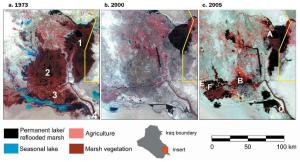
A composite view of the Mesopotamian marshlands

A composite view of the Mesopotamian marshlands from a mosaic of four Landsat 1 images and two false-color, near-infrared images, 1973–1976. Dense marsh vegetation (mainly Phragmites australis) appears in dark red, seasonal lakes in blue, agriculture in pink, and permanent lakes in black. The red elongated patches along riverbanks are date palms. The three main marsh areas are Al-Hawizeh, Central, and Al-Hammar, labeled 1, 2, and 3, respectively. The city of Basrah is located at number 4.Modified from Richardson and colleagues (2005). (b) A Landsat 7 Enhanced Thematic Mapper mosaic taken in 2000. Most of the drained marshes appear as grayish-brown patches, indicating dead marsh vegetation or low desert shrubs and dry ground. The white and gray patches indicate bare areas with no vegetation and, in some areas, salt evaporites or shells covering the bottoms of former lakes. By 2000, 85% of the 8926 square kilometers (km2) of permanent marsh in 1973 marshlands had been destroyed. Only 3% of the Central marsh and 14.5% of the Al-Hammar remained. Sampling sites: A, Al-Hawizeh; B, Central; C, Al-Hammar; D, Al-Sanaf; E, Abu Zarag; F, Suq Al-Shuyukh. MODIS satellite image courtesy of the United Nations Environment Programme, Iraq Marshlands Observation System. Image and caption source: Restoring the Garden of Eden: An Ecological Assessment of the Marshes of Iraq (pdf).

Iraq Dust Storms


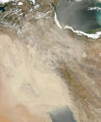
Beginning in mid April,  and continuing through may, and June dust storms plagued Iraq. In late June/early July 2009, the worst dust storm in living memory struck Iraq, spreading throughout the region, NASA EO reported. A new storm lashed Iraq again at the end of July.

See early July images

Sandstorms in Iraq


Since the turn of the twenty-first century, the frequency and duration of such storms have increased. Beginning in late June 2009, the worst dust storm in living memory struck Iraq and spread to neighboring countries. Another storm raged over Iraq again at the end of July. The Moderate Resolution Imaging Spectroradiometer (MODIS) on NASA’s Aqua satellite captured this true-color image of Iraq on July 30, 2009, the second consecutive day of heavy dust over the country. Thick dust blows southeastward over the Tigris and Euphrates floodplain and the Persian Gulf. The dust is thick enough to completely hide the land surface and water bodies below.

NASA image by Jeff Schmaltz, MODIS Rapid Response Team, Goddard Space Flight Center. Caption by Michon Scott. [Edited by FEWW]

Related Links:

Other Related Links:

Posted in destruction of infrastructure, drought in Iraq, food self sufficiency, Mesopotamian marshlands, War of occupation | Tagged: , , , , | Leave a Comment »

Image of the Day: Sandstorm in Saudi Desert

Posted by feww on March 11, 2009

She buries me; she buries me not.

saudi-sand-storm-ap1
A massive sandstorm engulfs Riyadh, capital of Saudi Arabia. Photo Jad Saab/AP. Image may be subject to copyright.

APTOPIX Mideast Saudi Arabia Weather
A huge sandstorm engulfs the Saudi capital of Riyadh, Saudi Arabia, Tuesday, March 10, 2009. The storm, which was still raging hours after it started, disrupted flights at the city’s King Khalid International airport, with weather authorities announcing that visibility would drop to zero, and warning residents to take precautionary measures. (AP Photo/Jad Saab) – AP (signonsandiego).

arabian_dust-storm
Dust plumes swept across the Arabian Peninsula in early March 2009, stretching from the Red Sea to the Persian Gulf and beyond. The Moderate Resolution Imaging Spectroradiometer (MODIS) on NASA’s Aqua satellite captured this image on March 11, 2009.   Image source: GSFC

Related Links:

Posted in dust bowl, dust storm, Riyadh, Rub’ al Khali, sand seas | Tagged: , , , , | 6 Comments »

Who needs Chesapeake crabs?

Posted by feww on March 5, 2009

Our Oceans, where life started Are Now Dying!

What is killing them? Among major causes Pollution from

  • Tourism
  • Coastal Developments
  • Industrial agriculture
  • Intensive farming
  • Coal-burning power plants
  • Shipping
  • Dumping

Causing

  • Eutrophication and Hypoxia
  • Desertification
  • Acidification
  • Dead Zones

Our Dead Zone Largest Ever This Year!

Ocean “deserts” are expanding much faster than predicted, it is believed that the ocean “desertification” may result in the population decline of many fish species.

globe2s.jpg
Black areas in the Atlantic and Pacific Oceans are the least productive. (Credit NOAA)

Development takes toll on Chesapeake crabs

Wed Mar 4, 2009
By Andy Sullivan

REEDVILLE, Virginia (Reuters) – It doesn’t look like a disaster area.

Crab boats dart back and forth on this inlet of the Chesapeake Bay as they have for generations. On the shore, million-dollar vacation homes catch the morning sun.

But watermen aren’t pulling blue crabs out of the Bay this winter. After years of decline, the U.S. Commerce Department declared the fishery a federal disaster last September and Maryland and Virginia shut it down until spring.

It was a symbolic as well as an economic blow for the men who harvest the region’s defining culinary treat.

Watermen faced a stark choice: Stay ashore until March, or take a state job pulling abandoned crab traps and other junk from the bottom of the Bay.

So on this frigid winter morning, Spencer Headley is on cleanup duty, a floating janitor on one of the country’s most intractably polluted bodies of water.

It’s decent money — $300 a day plus expenses — and you can’t beat those government hours. But Headley, 32, wonders why he must now rely on the state rather than the water for his livelihood.

“We’re not trying to tear the Bay up. We’re just trying to make a living off a fishery that’s been going for more than 100 years,” he says, one eye on his sonar display.

“Why all of a sudden is it a disaster?”


The Susquehanna River, which enters the Chesapeake Bay at its northern end, carries 40 percent of the nitrogen that flows into the Bay—the largest single source. There is so much nitrogen in the northern Bay that algae have all the “fertilizer” they need, and changes in streamflow do little or nothing to affect the growth of algal blooms. This satellite image shows brown water flowing from the Susquehanna. (NASA image by Robert Simmon, based on Landsat-7 data provided by the UMD Global Land Cover Facility. Caption: Earth Observatory).

STEADY STREAM OF POLLUTANTS

That disaster has been steadily building since Europeans first mapped the Bay’s shores 400 years ago.

Stretching roughly 200 miles from northern Maryland to southern Virginia, the Chesapeake is the largest estuary in the United States and for hundreds of years was one of its most productive fisheries, yielding shad, sturgeon, oysters and baitfish. As recently as 1993, the Bay accounted for about half of the country’s blue crab harvest.

But the fishery has declined as the region has boomed. Roughly 16.6 million people live in its watershed, which stretches as far as upstate New York, and an average of 439 more move to the region each day. That means more houses and more traffic as urban sprawl eats up forests and farmland.

The impact of this growth can be seen along Sligo Creek, which draws herons and foxes to its banks as it winds through the densely packed suburbs northeast of Washington, D.C.

Along the way, the creek picks up a steady stream of pollutants: lawn fertilizer, pet feces, motor oil and silt, washing off the parking lots and other hard surfaces that cover 35 percent of its 12-square-mile watershed.

Local activist Bruce Sidwell points out a sewer line that runs across the creek, exposed by years of erosion. It could be leaking raw sewage before long.

Sidwell’s grass-roots group reports polluters and organizes litter pickups, and he’s eager to showcase the filtering pools that help clean the creek’s upper reaches.

But water quality remains poor and is not likely to improve without substantial changes in the landscape, Sidwell says.

“It would take quite an effort to get it up to ‘fair’ water quality,” he says.

On its journey to the Chesapeake, water from Sligo Creek mingles with runoff from farms and sewage treatment plans.

Nitrogen and phosphorus in that runoff feed massive algae blooms that suck oxygen out of the water each summer, killing clams and worms that provide the blue crab with food and aquatic grasses that give it shelter.

Last year, the “dead zone” covered 40 percent of the Bay.

Not surprisingly, crabs have suffered. The 2007 catch was the worst in recorded history, and last year the catch was even worse in Virginia and only slightly better in Maryland.

With fewer crabs in the Bay, watermen now routinely catch far more than the 46 percent that scientists say is the upper limit to maintain a healthy population.

Observers say time is running out to reverse the damage.

“The Bay is now degraded to the point that its basic ability to withstand even low levels of pollution is in jeopardy,” said Naval Academy professor Howard Ernst, an expert on the restoration effort.

A 25-year, $6 billion cleanup effort by state governments and the U.S. Environmental Protection Agency has come under widespread criticism as it has repeatedly fallen short of its stated goals. Officials also overstated their success to keep funding in place.

The Chesapeake Bay Foundation, an environmental group, sued the EPA last month to force it to set a firm cap on pollutants. The group is heartened that new EPA Administrator Lisa Jackson has promised to make the Bay cleanup a priority.

“We certainly are hearing the right words,” said foundation president Will Baker. “But to be honest, we have heard those words for 30, 35 years and what we need to see is action.”

‘GRASS THAT’S PAINTED ON’

Headley has seen the changes up close. He’s pulled up traps filled with dead crabs, suffocated in oxygen-depleted water. He’s seen the state reduce the number of traps he’s allowed to drop in the water from 500 to 350.

And he’s seen mansions sprout along the shoreline, their lawns fertilized with the very chemicals that are choking the Bay. “Grass as green as you’ve ever seen in your life, looks like it’s painted on,” he says.

Easing his 46-foot (14 meter) Chesapeake Bay Deadrise back to the dock, Headley passes rusted shacks and crumbling chimneys, the ruins of once-thriving oyster and baitfish industries.

The crab fishery, too, is a shadow of its former self, employing 40 percent fewer jobs than it did a decade ago.

There are only a handful of crabbers working out of Reedville now, Headley says, but plenty of people are moving to town to enjoy the scenery.

Headley knows everybody on the water, but sometimes when he comes ashore he doesn’t recognize a soul. A way of life is dying. (Editing by Alan Elsner). Copyright the author or news agency. URL: http://www.reuters.com/article/environmentNews/idUSTRE52302020090304

Related Links:

    Posted in Coastal Developments, Continental Shelf, dead zones, pollution, Susquehanna | Tagged: , , , , | 2 Comments »

    Southern South America Gripped by Drought

    Posted by feww on March 1, 2009

    Drought in Southern South America

    Earth Observatory acquired image January 17, 2009 – February 1, 2009

    More than mere colors on the page, the blotches of brown and cream—with only faint dustings of green— in this image represent the impact of one of the worst droughts in southern South America in decades. Each tiny dot of brown is a two-kilometer square of land (250 meters per pixel in the large image) where plants were struggling to grow in the hot, dry weather. Since northern Argentina, Uruguay, and southern Brazil contain rich, intensively cultivated land, the dots include fields of corn, cotton, soy, wheat, or pastureland for grazing cattle. The brown tones reveal that these plants were growing far less vigorously than average in late January 2009.

    From mid-November 2008 through mid-February 2009, unusual weather patterns brought extreme temperatures and low rainfall to this normally productive agricultural region. The period is critical for many crops, including cotton, wheat, soy, and corn. As a result, crop yields in the three countries were expected to dip, with Argentina suffering the worst blow, said the U.S. Department of Agriculture’s Foreign Agricultural Service (FAS). Even Argentina’s famous beef industry had been affected by the drought, reported BBC News, as pastureland disappeared, and cattle starved.

    Considered individually, many of the brown dots in the image represent a personal disaster, a farmer facing the prospect of a poor harvest or a herd of malnourished or dying cattle. As a whole, the image conveys something of the severity and extent of the disaster. In simple terms, the vegetation index is a scale of the amount of light plants absorb during photosynthesis. By comparing current vegetation index values with values recorded at the same period in previous years, scientists can tell how well plants are growing. While the impact of drought on vegetation is occasionally visible in photo-like satellite imagery, the vegetation index comparison is a more precise way to evaluate the impact of drought.

    This image, based on observations from the Moderate Resolution Imaging Spectroradiometer (MODIS) on NASA’s Terra satellite, compares the vegetation index for January 17–February 1, 2009, to the average vegetation index during the same period from 2000 through 2008. Brown shows where the current vegetation index is lower than average, meaning that less photosynthesis was occurring; cream shows where conditions were average; and the few spots of green show where the vegetation index was higher than average. Darker shades of brown stretch from the Pampas grasslands of Argentina to the croplands in southern Brazil. Severe drought clearly impacted the entire region.

    References

    • Foreign Agricultural Service. (2009, February). World Agricultural Production. Published in Crop Explorer.

      • United States Department of Agriculture.
      • Accessed February 27, 2009.
    • Piette, C. (2009, February 23). Drought sucks life from Argentina’s farms. BBC News.

      • Accessed February 27, 2009.
    • NASA image created by Jesse Allen, Earth Observatory, using data provided by Inbal Reshef, Global Agricultural Monitoring Project. Caption by Holli Riebeek.
    • Instrument: Terra – MODIS

    Posted in argentina, crop failure, southern Brazil, southern South America, Uruguay | Tagged: , , , , | Leave a Comment »

    More Droughts in 2009

    Posted by feww on February 25, 2009

    Argentina’s 2009 crop production was 40-70 lower than in 2008, depending on the crop

    Drought in Argentina


    NASA Earth Observatory Image: acquired February 23, 2009


    NASA Earth Observatory Image: acquired February 22, 2008

    USDA Foreign Agricultural Service (FAS) reported a severe drought in southern South America, which had severely affected corn, cotton, and soybean crops in Argentina. Total rainfall since December was far below normal in most areas, and the rain that did fall often did not coincide with key points in crops’ growing cycles. Dust storms occurred in January and again in February, despite some late-to-arrive rains.

    [NOTE: Dust storms destroy topsoil and accelerate land erosion. According to estimates made by our colleagues at EDRO, by 2012 critically low levels of top soil will have been reached at which point significant crop failures would occur worldwide.]

    This pair of natural-color (photo-like) images from the Moderate Resolution Imaging Spectroradiometer (MODIS) on NASA’s Terra satellite contrasts 2009 conditions (top) in southern Buenos Aires province with the conditions in 2008 (bottom), a more normal year. The province is one of the country’s major corn-growing areas. The difference in overall greenness is dramatic. In 2008, the area was a checkerboard of lush green, a sign that crops were healthy. In the 2009 image, the landscape was pale green and tan, reflecting the struggle that natural and cultivated vegetation was having with the hot, dry summer.

    FAS analyst Denise McWilliams said 2009 crop production was 30-60 percent of what it was in 2008, depending on the crop. Drought stress made the corn crop susceptible to insect pests, and in some fields, farmers simply baled the stunted corn crop for use as livestock forage. Likewise, extreme heat and drought struck the season’s first soybean crop during its flowering and seed pod development phase. Meanwhile, the drought and heat caused wide differences in the height and maturity level of cotton crops, even within the same field, which was expected to complicate the harvest.

    References:

    • USDA Foreign Agricultural Service Office of Global Analysis. (2009, February). World Agricultural Production. (pdf) Accessed February 23, 2009.

    NASA images by Jeff Schmaltz, MODIS Rapid Response Team. Caption by Rebecca Lindsey [with minor editions made by FEWW], with input provided Denise McWilliams, USDA Foreign Agricultural Service.

    Instrument:  Terra – MODIS

    Related Links:

    Posted in anthropogenic CO2, Climate Change, crop failure, Dust storms, human impact | Tagged: , , , , | Leave a Comment »

    North China on Drought Red Alert

    Posted by feww on February 6, 2009

    Drought: A China’s Arch Nemesis

    “The wheat grass gets so dry that it catches fire! I’ve never seen this in my whole life,” said 50-year-old Wei Liuding, a farmer from north China’s Henan Province.

    “All the wheat in my land is dying like this,” he told a Xinhua reporter, as he opened his hand revealing a bunch of dead grass.

    Source: United Nations Office for the Coordination of Humanitarian Affairs – ReliefWeb

    Henan, heart of China’s bread basket, issued a drought red alert February 5. “The provincial meteorological bureau said the drought is the worst since 1951. The drought have affected about 63 percent of the province’s 78.9 million mu (5.26 million hectares) of wheat.” Xinhua reported.

    Photo dated Feb. 2, 2009 shows the dry reservoir in Yiyang County of Luoyang city, central China’s Henan Province. (Xinhua Photo). Image may be subject to copyright.

    Other provinces in northern China haven’t been spared by the persistent drought, either.

    Anhui Province, which  issued a drought red alert Sunday, forecasts a major drought that could destroy more than two thirds of the crops north of the Huaihe River, unless it rains by no later than next week.

    Shanxi Province was put on drought orange alert on January 21;  about a million people and 160,000 heads of livestock face water shortages.

    Other provinces including Hebei and Jiangsu Shaanxi, Shandong are also affected by droughts.

    Until the well runs dry! Villagers irrigate the thirsty wheat field with water from well in Gaoshan Township of Luoyang city, central China’s Henan Province, Feb. 2, 2009. (Xinhua Photo). Image may be subject to copyright.

    Rainfall in north and central China was 50 to 80 percent lower than normal. About 155 million mu (10.33 million hectares) of crops are affected by the drought, according to data  released by the Office of State Flood Control and Drought Relief Headquarters on Thursday.

    “The rare drought which began in November, has threatened 143 million mu of winter wheat, with 46.35 million mu seriously affected.” The report said. [15 mu = 1ha.]

    “Some 4.29 million people and 2.07 million livestock lack proper drinking water,” the report said.

    Some areas have had no rain for nearly 4 months. The drought is threatening about 43 percent of the country’s winter wheat supplies.

    Related Links:

    Posted in grain production, Henan Province, Huaihe River, Xiaolangdi Dam, Yellow river | Tagged: , , , , | Leave a Comment »

    Images of the Day: California Drought & Folsom Lake

    Posted by feww on February 4, 2009

    Desertification of California Continues


    Folsom Lake’s water level is way down; mandatory conservation efforts are likely soon. Meanwhile, Sacramento has been criticized for its water gluttony: The city’s per capita water use, at 278 gallons per day, is double the state average. Many residents falsely assume water simply flows back into local rivers. Not true, says the data. Photo: AUTUMN CRUZ/ Sacramento Bee. Image may be subject to copyright.

    Sacramento received only 1.5 inches of rain in January, compared with the historical average of 4.2 inches, the National Weather Service said.


    US Seasonal Drought Outlook – Source NOAA/ NWS Climate Prediction Center

    Related News Links:

    Related Links:

    Posted in Collapsing Cities, Drought, land degradation, Mojavefication, Sacramento | Tagged: , , , , | 3 Comments »

    Warning: California Is Being Mojavefied!

    Posted by feww on January 30, 2009

    Moderators have previously warned the readers about the real possibility of California being “Mojavefied,” i.e, undergoing a rapid process of desertification, with the critical phase occurring by as early as 2011.

    The following facts, including the new snow survey, supports our analysis:

    California faces historic drought, snow survey says

    California Facts:

    • California is facing one of the worst droughts in its history! Gov. Arnold Schwarzenegger said.
    • The ‘Golden State’ produces about 53 percent of the United States’ vegetables and fruit
    • California is now in its third year of drought;  its main system which supplies water to cities and farms may only be able to fulfill 15 percent of requests, Reuters reported scientists as saying.
    • The Sierra snowpack this year is carrying just over one half of California’s water supply.
    • The Sierra has only received about one third of its anticipated annual snowfall during its wettest period.

    “California is headed toward one of the worst water crises in its history, underscoring the need to upgrade our water infrastructure by increasing water storage, improving conveyance, protecting the (Sacramento) Delta’s ecosystem and promoting greater water conservation,” Schwarzenegger said.

    “We may be at the start of the worst California drought in modern history,” said Water Resources Director Lester Snow.

    The period December through January is normally the wettest in California, however, the Sierra has only received about one third of its anticipated annual snowfall.

    “A third of normal is devastating,” said Elissa Lynn, a state meteorologist. “January is the biggest month for precipitation in the Sierra.”

    “Climate change does indicate the possibility of more frequent droughts,” said Lynn, “but it’s hard to tell over a short time span.”

    A La Nina has pushed down the ocean temperatures in the equatorial Pacific, which has meant less precipitation in Northern California. The precipitation didn’t slow down until about early April last year, which was also a La Nina year.

    “This could be a crisis situation,” said Lynn. “In addition to conservation and rationing we could be paying higher prices for produce.” Lynn said that some farmers have left fields unplanted based on expected lack of water.

    “Twenty-five local water agencies are already mandating rationing. The state Department of Water Resources is arranging water transfers through its Drought Water Bank program and expects to release a full snowpack runoff forecast in two weeks.” Reuters said.

    Next on EDRO : How Climate Change and Food Shortages Will Lead to Large Scale Riots in the United States

    Related Links:

    Posted in Arnold Schwarzenegger, Climate Change, Sierra snowpack, Uncategorized, water crises | Tagged: , , , , | 1 Comment »

    Cyprus Is Collapsing!

    Posted by feww on July 17, 2008

    Cyprus’ extreme environmental stress may lead to early collapse!

    Former offical: We are going through a visual process of desertification.”

    Goto Main Entry >> Cyprus Collapse May Be Imminent!

    Related Links:

    Posted in Climate Change, energy, environment, food, Global Warming, health, politics, topsoil, Tourism, Travel, water, wildfires | Tagged: , , , , , | Leave a Comment »

    No Fertile Land, No Food!

    Posted by feww on July 2, 2008

    Accelerated land degradation threatens food security of a quarter of the world’s population: FAO

    Main entry: Land degradation threatens 1.5 billion people


    A dried up river filled with sand winds its way across the desert in eastern Chad, June 5, 2008. REUTERS/Finbarr O’Reilly.
    Image may be subject to copyright. See FEWW Fair Use Notice!

    Related Links:

    Posted in Climate Change, energy, environment, food, Global Warming, health, politics | Tagged: , , , , , , , , , , , , , , , , , , , , , , , , , , , , , , , , , | Leave a Comment »

    Schwarzenegger Proclaims Water Emergency in Nine Counties

    Posted by feww on June 13, 2008

    A Shrinking World Series

    Could California Turn to Desert by 2011?

    Water, water, my bloody kingdom for a drop of water. ~ King Conan

    Water Emergency in Calif

    As most of the croplands in the Central U.S. is submerged under floodwater, the heart of California’s farming area is feeling the heat. Gov. Schwarzenegger who proclaimed last week a drought in California, declared yesterday a state of emergency in nine counties in Central Valley.

    “Just last week, I said we would announce regional emergencies wherever the state’s drought situation warrants them, and in the Central Valley an emergency proclamation is necessary to protect our economy and way of life,” Mr Schwarzenegger said.

    “Central Valley agriculture is a $20 billion a year industry. If we don’t get them water immediately the results will be devastating,” he added. “Food prices, which are already stretching many family budgets, will continue to climb and workers will lose their jobs—everyone’s livelihood will be impacted in some way.”

    “His declaration covers Sacramento, San Joaquin, Stanislaus, Merced, Madera, Fresno, Kings, Tulare and Kern counties and directs California’s Department of Water Resources to work with the U.S. Bureau of Reclamation to deliver more water through the State Water Project to where it is most needed.” Reuters reported.

    Conservation Action:

    • Water rationing is imposed in Long Beach, Roseville and the East Bay Municipal Utility District, which serves 1.3 million people in the San Francisco Bay area.
    • Water agencies serving about 18 million people throughout Calif have declared a water supply alerts.
    • Officials are planning for reduced water use through this year because lower water supplies are anticipated next year.
    • Schwarzenegger is asking lawmakers to back a “comprehensive solution” to expanding water and says he needs $11.9 billion bond to finance water projects. (Source)


    Coyote Dry Lake, Mojave Desert. Image: Jeff T. Alu via Wikimedia. This file is licensed under the terms of the GNU Free Documentation license, Version 1.2 or any later version published by the Free Software Foundation.

    Coyote Dry Lake is a dry lake bed in the Mojave Desert located about 24 km northeast of Barstow, and north of Interstate 15 in southern California. The lake measures about 10 km long and about 6 km wide at its widest section.

    California’s Last Chance: Do a U-Turn, or Turn to Desert!

    Related news:

    Related Links:

    feww

    Posted in Climate Change, energy, environment, food, Global Warming, health, politics, Tourism, Travel | Tagged: , , , , , , , , , , , , , , , , , , , , , , , , , , , , , , , , , , , , , | 4 Comments »

    Could California Turn to Desert by 2011?

    Posted by feww on June 5, 2008

    Bets are on!

    Schwarzenegger declares statewide drought

    Gov. Arnold Schwarzenegger declared a statewide drought in California after two years of below-average rainfall. “We have a serious drought,” said Governor Schwarzenegger on Wednesday.

    “For the areas in Northern California that supply most of our water, this March, April and May have been the driest ever in our recorded history,” Schwarzenegger said. “As a result, some local governments are rationing water, developments can’t proceed and agricultural fields are sitting idle.”

    “We must recognize the severity of the crisis we face, so I am signing an executive order proclaiming a statewide drought and directing my Department of Water Resources and other entities to take immediate action to address the situation.”

    The executive order enables water officials transfer water around California swiftly dealing with unusually dry conditions that are destroying crops, affecting water quality and creating extreme fire hazards across the state, one of the nation’s top farming regions.


    To enlarge, right click on the image and select View Image

    “Mr Schwarzenegger warned that conditions could be even worse next year if there was another dry winter. The governor wants voters to approve a $12 billion bond to fund delta, river and groundwater improvements, conservation and recycling efforts, and reservoirs. But legislators have not agreed to the plan despite ongoing negotiations with the administration.” USA today reported.

    “This drought is an urgent reminder of the immediate need to upgrade California’s water infrastructure,” Schwarzenegger said. “There is no more time to waste because nothing is more vital to protect our economy, our environment and our quality-of-life.”

    [Note: Gov Schwarzenegger’s statement is fundamentally flawed and factually incorrect because “to protect our economy,” i.e., business as usual, results in the destruction of “our environment” and therefore harms “our quality of life.”]

    Related Links:

    [Nothing short of a catastrophic ecosystem collapse would make humans change their unsustainable lifestyles!]

    Posted in air soil and water pollutions, civilization, Climate Change, CO2, CO2e, Coastal areas, Collapsing Cities, conserve, economy, energy, environment, food, Global Warming, government, health, politics, Water pollution, water shortages | Tagged: , , , , , , , , , , , , , , , | Leave a Comment »