
Record low Arctic sea ice maximum extent also occurs early this year
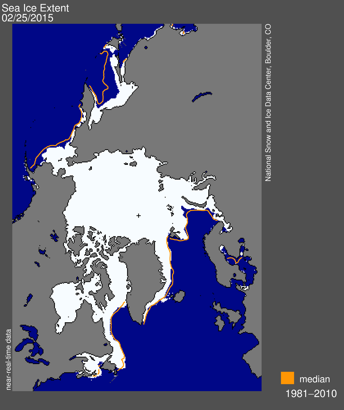
Arctic sea ice extent appeared to have reached its annual maximum extent at 14.54 million square kilometers (5.61 million square miles), on February 25, 2015, marking an early start of the melt season, said National Snow and Ice Data Center (NSIDC).
The 2015 maximum extent occurred 15 days earlier than the 1981 to 2010 average date of March 12, however, a late season surge in ice growth could still occur, said NSIDC, adding that it will post a detailed analysis of the winter sea ice conditions in April.
Measured at 14.54 million square kilometers (5.61 million square miles), the lowest in the satellite record that began in 1979. the ice probably reached its maximum extent for the year on February 25. The maximum extent was 1.10 million square kilometers (425,000 square miles) below the 1981 to 2010 average of 15.64 million square kilometers (6.04 million square miles) and 130,000 square kilometers (50,200 square miles) below the previous lowest maximum that occurred in 2011, said NSIDC.
Below-average ice conditions were observed everywhere except in the Labrador Sea and Davis Strait. This year’s maximum occurred 15 days earlier than the 1981 to 2010 average date of March 12. The date of the maximum has varied considerably over the years, occurring as early as February 24 in 1996 and as late as April 2 in 2010.
“Over the next two to three weeks, periods of increase are still possible. However, it now appears unlikely that there could be sufficient growth to surpass the extent reached on February 25.”

Arctic sea ice extent for February 25, 2015 was 14.54 million square kilometers (5.61 million square miles). The orange line shows the 1981 to 2010 median extent for that day. The black cross indicates the geographic North Pole. Sea Ice Index data. About the data. Credit: National Snow and Ice Data Center. High-resolution image
Temperatures throughout the eastern Arctic were several degrees Celsius above average at the 925 hPa level (approximately 1,000m, or 3,000 feet altitude) during the first half of March, and climbed as much as 8 to 10 degrees Celsius (14 to 18 degrees Fahrenheit) above average in the Barents Sea between Svalbard and Franz Josef Land, reported NSIDC.
Minimum Ice Extent
The Arctic sea ice will reach its annual minimum extent in September (assuming that there would still be some ice left this year!)
The ice reached its lowest minimum cover in 2012 with 2.11 million square kilometers (1.31 million square miles), which was about 483,000 square kilometers (300,000 square miles), or 18.6 percent, lower than the previous record low of 2.59 million square kilometers set in 2007.
