A Magnitude 7.4 Earthquake Could Strike Timor Sea Region
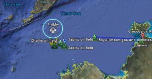
FEWW Moderators believe that a powerful 7.4 Mw earthquake followed by a large cluster of aftreshocks may strike Timor Sea Region anytime.

Map of the FEWW quake forecast in Timor Sea. Original map: Google Earth. Image may be subject to copyright.
Details of FEWW Earthquake Forecast
- Magnitude: 7.4 or greater
- Estimated Date: November 30, 2009 [Uncertainty: T±90 days]
- Epicenter: 11°34’23.78″S, 124°45’28.10″E
- Location: Timor Sea
- Depth: 27km [Uncertainty: +/- 6.8km]
- Distances:
- 109 km NW of Challis Oil Field (See Australian Oil Disaster May Get a Lot Worse)
-
- 160km South of the southern coast of West Timor, province of East Nusa Tenggara, Indonesia.
- 190 km ENE of Ashmore Island [Ashmore and Cartier Islands]
- 203 km NW Kupang, West Timor
- 281 km NNW of Troughton Island, North Kimberly Coast, NW Australia
- 666 km WNW of Darwin Australia
- Horizontal Uncertainty: radius of about 60 km from the forecast epicenter
- Probability of Occurrence: 0.7 (72%)
Note: This forecast does NOT preclude the possibility of other seismic events in the area at any time.
Related Links:
