Fire Earth

Earth is fighting to stay alive. Mass dieoffs, triggered by anthropogenic assault and fallout of planetary defense systems offsetting the impact, could begin anytime!

Archive for June 7th, 2011

Puyehue Volcanic Range Continues Ejecting Ash

Posted by feww on June 7, 2011

Puyehue continues to spew ash as volcanic seismicity re-intensifies: Reports

Chilean officials expand the evacuation zone around a volcanic complex as it continues to eject thousands of tons of ash each hour.

The national emergencies office (ONEMI) fears that volcanic ash and pumice could clog up rivers and waterways causing flooding, or trigger lahars, as rain hits the area.

The rain is expected to continue for at least several days.

“The forecast is for more rain on Tuesday, Wednesday and Thursday,” an ONEMI official told a local news agency.


Frame grab from a video clip taken June 6, 2011. Click HERE for the video link.


War of the Volcanoes: Golf-ball size pumice ejected in the eruption have landed as far away as 25 km from the volcano. Photo credit: Reuters/via BBC. More images …

Click animation link to view the transport of the plume from 1:45 pm local time June 4, 2011, until 10:45 am June 6, 2011.

Buenos Aires, Argentina – Volcanic Ash Advisories

  • VA ADVISORY DTG: 20110607/1330Z
  • VAAC: BUENOS AIRES VOLCANO: CORDON CAULLE 1507-15
  • PSN: S4052 W07220
  • AREA: CHILE-C
  • SUMMIT ELEV: 1798M
  • ADVISORY NR: 2011/014
  • INFO SOURCE: GOES 12 – GFS MODEL ERUPTION
  • DETAILS: CONTINUOUS EMISSION OBS ASH
  • DATE/TIME: 07/1230Z OBS
  • ASH CLOUD: SFC/FL180 VA CLD 35 NM WIDE LINE BTN S4052 W06630 – S4127 W07053 – S4200 W06956 – S4318 W06907 – S4432 W06905 FCST ASH CLD +06HR: 071930Z SFC/FL180 S4052 W07220 – S4130 W0550 – S4200 W06140 – S4400 W06130 – S4230 W06640 – S4052 W07220 FCST ASH CLD +12HR: 080130Z SFC/FL180 S4052 W07220 – S4100 W06700 – S4130 W063500 – S4230 W05800 – S4600 W05800 – S4310 W06454 – S4133 W06930 – S4052 W07220 FCST ASH CLD +18HR: 080730Z SFC/FL180 S4052 W07220 – S4000 W06700 – S4000 W06300 – S4300 W05400 – S4500 W05800 – S4200 W06400 – S4052 W07 220
  • REMARKS: VA PLUME IS VISIBLE IN MULTISPECTRAL SATELLITE IMAGERY AREA OF REMANENT VA ASH FROM PREVIOUS EMISION BTN FL160/230 AT S2555 W05636 – S2715 W05545 – S3028 W05628 – S3442 W05423 – S3750 W05000 – S3450 W05555 – S3021 W05746 – S2623 W05744 – S2555 W05636 MOV ESE 50K T NEXT ADVISORY: WILL BE ISSUED BY 20110607/1930Z

Related Links

FIRE-EARTH Volcano Watch

Posted in chile plate tectonics, Chile Ridge, Chile volcano, volcano | Tagged: , , | Leave a Comment »

Puyehue Volcano Satellite Images

Posted by feww on June 7, 2011

Massive Eruption Covered Large Regions in Ash and Pumice

The Eruption Aftermath

The volcanic ash blanketed the Andes and Patagonia regions with a thick blanket of ash and pumice before reaching the Argentine Atlantic Coast. The cities affected by the ash included Puerto Madryn and Trelew, in Chubut, as well as the towns of San Carlos de Bariloche and Villa La Angostura, a report said.

“Local authorities assured there is a layer of ash that’s at least 30 centimetres high over the National Route 40 in the area close to Bariloche and Neuquén. Border patrol has discouraged residents from driving in the area.”


A fissure on Puyehue-Cordón Caulle volcanic range opened on June 4, 2011, ejecting ash to a height of about 16km. Natural-color image captured by MODIS on the Aqua satellite moments after eruption began.
Source: NASA-EO. Click image to enlarge.


Eruption at Puyehue-Cordón Caulle began on June 4, 2011. This natural-color satellite image was taken by the MODIS aboard Terra satellite on the early morning of June 6, 2011, when according to the Buenos Aires Volcanic Ash Advisory Center the ash plume was reaching an altitude of about 12km above the summit crater.  Source: NASA-EO. Click image to enlarge.

Click animation link to view the transport of the plume from 1:45 pm local time June 4, 2011, until 10:45 am June 6, 2011.

Related Links

FIRE-EARTH Volcano Watch

Posted in environment | Tagged: , , | Leave a Comment »

Arizona’s Wallow Fire Grew by 61 pct

Posted by feww on June 7, 2011

Arizona’s Wallow Fire May Become the State’s 2nd Largest Today

The mega blaze in Apache-Sitgreaves National Forest (eastern Arizona) has grown from just under 144,000 acres to about  233,000 acres, a rise of more than 61 percent in less than 24 hours, forcing thousands of people from their homes and casting a thick smoky haze over a large region as far away as Iowa.

Arizona Gov. (Jan Brewer) declared a state of emergency retroactive to May 29 in Apache and Greenlee Counties in response to the out-of-control Wallow Fire, which had  grown to 233,522 acres in size as of Monday afternoon June 6, 2011.

FIRE-EARTH estimates that under the current conditions the mega blaze could grow by about 40 percent to 326,000 acres today.

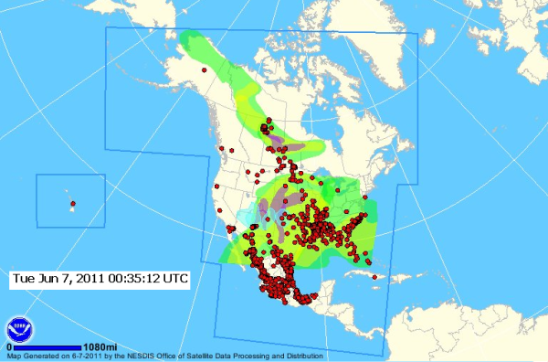
Fires and Smoke Satellite Analysis: North America


Source: NOAA. Click images to enlarge.


Click image to enlarge closeup view.


HMS Fire and Smoke Analysis released June 7, 2011. Click images to enlarge. Source: NESDIS


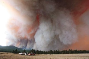
Wallow Fire.
Photo by Tam Altaha/@TamAltaha


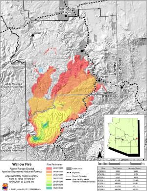
Map of Wallow Fire. Click image to enlarge. [Full Size]

Other Details

  • NO serious injuries reported, as of posting.
  • Up to a dozen structure, mostly cabins, have been destroyed.
  • Evacuations have been ordered in mountain town of Greer.
  • The towns of Blue and Luna in New Mexico are being  evacuated(?)
  • At least 2,515 firefighters are deployed (the number of personnel has doubled since 4 days ago).
  • About 3,000 residents of the towns of Alpine and Nutrioso have been evacuated.
  • The fire has forced the closure of the Apache National Forest.
  • Other towns and communities near the New Mexico border which have been evacuated include Bonita, Dog Patch, Escudilla Bonita, White Mountain Acres, H Bar Ranch and Bar Flying Ranch.
  • The Wallow Fire, currently Arizona’s third largest wildfire, started on May 29. It has grown rapidly since and could become the state’s 2nd largest by this afternoon.
  • The largest fire in Arizona history  was the 2001 Rodeo-Chediski Fire which consumed 469,000 acres.
  • The 2nd largest blaze, the 2005  Cave Creek fire near Phoenix, burned 248,000 acres.

Other Major Wildfires in Arizona

  • The Horseshoe Two fire. The blaze started May 8 and has burned at least 100,000 acres, currently 55 percent contained at a cost of about $30 million.
  •  Murphy fire. The blaze has burned about 37,566 acres near Tubac, and is less than 15 percent contained.
  • Arlene fire. The large fire in Coronado National Forest has burned 10,610 acres.

Wallow Fire Satellite Images (NASA/MODIS)


 June 6, 2011


June 5, 2011


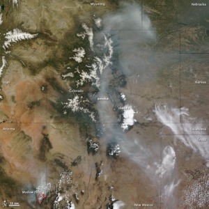
The Wallow Fire (lower left corner of the image) – Natural color/MODIS/ NASA/Terra/ June 5, 2011. “Smoke from an Arizona wildfire spanned multiple states in early June 2011. … the Wallow Fire pushed air quality to unhealthy levels as far east as Alabama and Georgia. Closer to the source of the fire, thick smoke traveled across Colorado and into Nebraska.” Source: NASA-EO 

United States Wildfire MAP

GEOMAC Wildfire Viewer

Related Links

Posted in US Wildfire | Tagged: , , , , , , , | Leave a Comment »