
Afar Triangle Volcano Erupts as Forecast
Posted by feww on June 14, 2011
Correction: Nabro Volcano in Eritrea Erupts Ejecting a 15-km Plume of Ash into the Atmosphere
Following a swarm of Earthquakes that struck within the Afar Triangle Eritrea, Ethiopia, yesterday, FIRE-EARTH said:
… there’s a strong probability that the quakes may have primed one or more regional volcanoes for eruption.
Nabro Volcano erupted around midnight Sunday local time, ejecting a 15-km plume of ash into the air, reports said.
The volcano, which is located about 375 km southeast of the Eritrean capital Asmara, sits within the Afar Triangle, a tectonic triple junction.

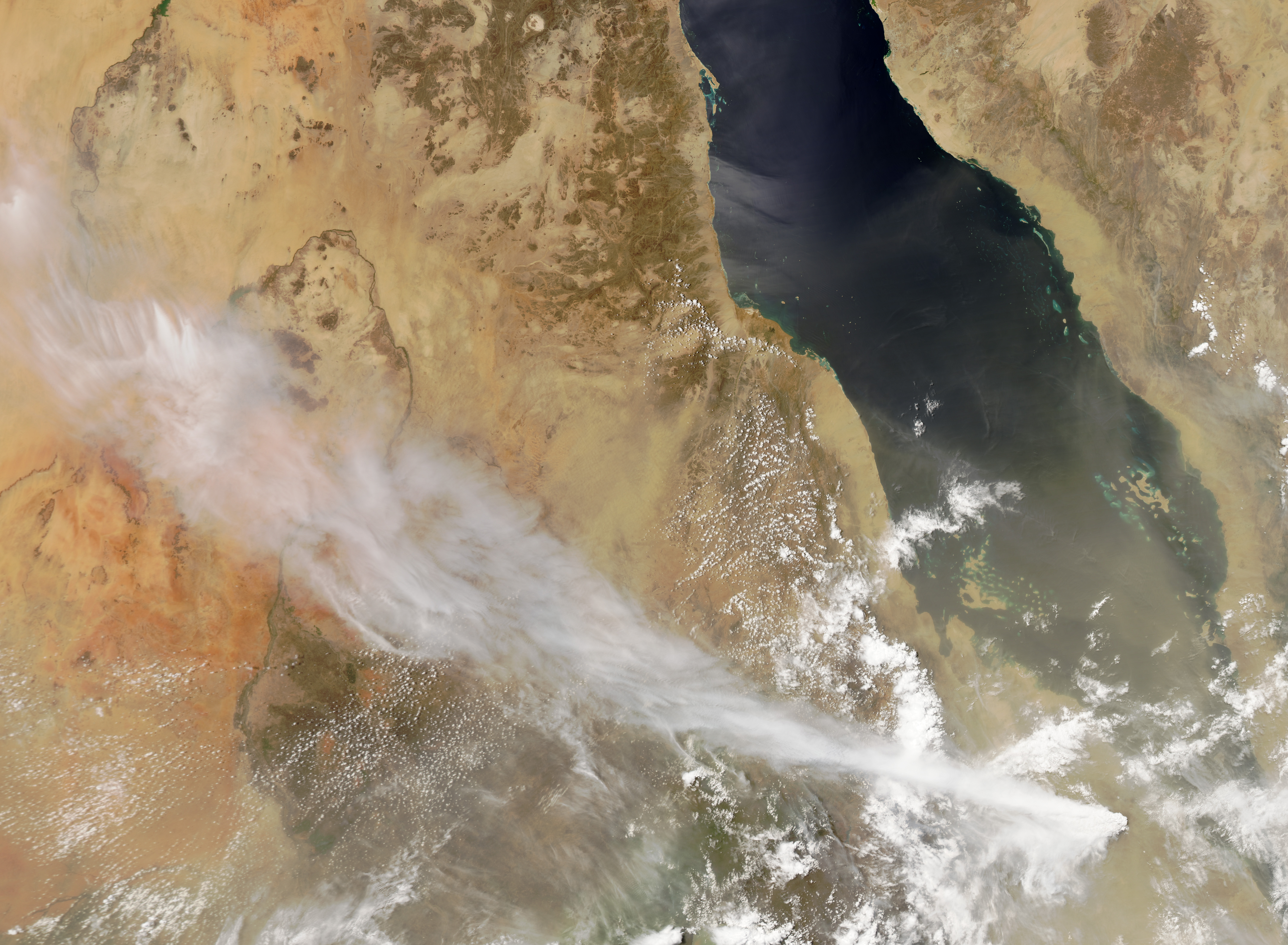
Nabro volcano, Eritrea, sits close to the border with Ethiopia. Credit: ESA/NASA. Click image to enlarge.

Nabro eruption is captured in this photo-like image by MODIS on the Aqua satellite on June 13, 2011. “Initial reports from news agencies and the Volcanic Ash Advisory Center in Toulouse, France, proclaimed the eruption to be occurring at Dubbi, a volcano further south. But later reports from volcanologists, field scientists, and the satellite image above appear to confirm the eruption at Nabro. There are no historical reports of eruptions at Nabro before today.” Image and caption: NASA-EO. Click image to enlarge. Download largest image (4 MB, JPG)
The fact that there was no historic record of eruption at Nabro volcano may explain why the French VAAC got it wrong initially, attributing the eruption to the Dubbi volcano – EDRO
Nabro Volcano
Country: Eritrea
Region: Northeastern Africa
Previous Known Eruption: NOT KNOWN
Summit Elevation: 2,218 m (7,277 ft)
Coordinates : 13.37°N, 41.70°E
Source: GVP
Nabro Volcano Space Shuttle image

The large caldera below and to the left of the center of this Space Shuttle photo of the Danakil Alps of Ethiopia is Nabro. The 2218-m-high Nabro stratovolcano is the highest volcano in the Danakil depression and is truncated by nested calderas 10 and 5 km in diameter. The larger caldera is widely breached to the SW. Nabro was constructed primarily of rhyolitic lava flows and pyroclastics. The 8-km-wide Mallahle caldera is at the lower left, and the dark-colored lava flows at the right are from Dubbi volcano. NASA Space Shuttle image S-61A-36, 1985. Caption: GVP

Nabro (top) and Mallahle (bottom) volcanic calderas. This false-color topographical image of the two volcanoes was produced by NASA. Click image to enlarge.

Map of East Africa showing some of the historically active volcanoes (red triangles) and the Afar Triangle (shaded, center)— a so-called triple junction (or triple point), where three plates are pulling away from one another: the Arabian Plate, and the two parts of the African Plate (the Nubian and the Somalian) splitting along the East African Rift Zone. Source: USGS

A map showing the approximate location of Nabro and Dubbi Volcanoes. The yellow circles mark the epicenters of the recent quakes that struck the area. Red stars are the two largest shocks in the swarm measuring 5.7Mw. Click image to enlarge.
The huge ash cloud ejected by the volcano is said to be moving across the Horn of Africa, threatening air travel. The German airline Lufthansa said on Monday it had cancelled two flights, one a flight out of the Eritrean capital Asmara, and the other into Addis Ababa.
The ash plume also forced the U.S. Secretary of State Hillary Clinton to curtail her visit to the region. Ironically, Obama was forced to abandon his visit to Ireland when Iceland’s Grímsvötn volcano erupted last month.
News Links
Related Links
Updated on June 14, 2011 at 07:58UTC by EDRO
Updated on June 14, 2011 @ 12:01UTC by FEWW

Leave a comment