Fire Earth

Earth is fighting to stay alive. Mass dieoffs, triggered by anthropogenic assault and fallout of planetary defense systems offsetting the impact, could begin anytime!

Posts Tagged ‘Australian Coal’

Australia Flood Update

Posted by feww on December 30, 2010

Queensland Floods: Worst yet to come

The cost of flood damage will probably exceed Australia’s income from selling coal

Climate Change Midterm Dividends

Australia is the world’s top coal exporter with an annual production of 333.5 million metric tons.


Source: Image from Japan Meteorological Agency satellite MTSAT-1R via Bureau of Meteorology. Captured: Thursday 30 December 2010 08:30 UTC.
Click HERE for the latest image. Click images to enlarge.


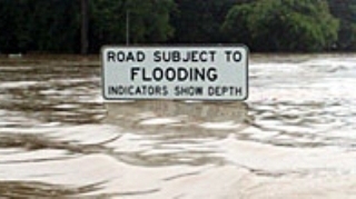
The road into Dalby (Queensland) has been cut by a sea of water. couriermail.com.au Reader picture: Anthony Skerman

Queensland Flooding News Highlights

The worst of floods is yet to come, forecasters say, as the cities of Emerald and Rockhampton are evacuated.

“Dozens of communities remain isolated with flooding at unprecedented levels in Bundaberg, Rockhampton, Emerald and a string of smaller towns as thousands of people were forced out of their homes, the Courier-Mail reported.

  • Shortages of safe food and water the biggest problem.
  • No end in sight for flood-ravaged Queensland’s residents
  • Disease outbreak now feared after flooding
  • Thousands are forced form their homes
  • A compulsory evacuation in the town of Condamine has just been completed, after the Condamine River reached a record 14.25m
  • State Premier Anna Bligh has said that flood damage to roads alone will cost at least $1.5 billion[so far]
  • “Hundreds of families across Queensland have been hard hit by the worst flooding in decades – in some cases, the worst on record,” she said.
  • The total cost of damage could reach 5 billion [blog estimates]
  • “[Flooding from the Fitzroy River in] Rockhampton is expected to reach about 9.4 metres by Tuesday with possible further rises.” The Bureau of Meteorology said.
  • “This is similar to the 1991 (9.3m) and 1954 (9.4m) flood levels. Rockhampton river levels are expected to remain above 9 metres for up to 10 days.”
  • “Central Highlands Mayor Peter Maguire estimates 90 per cent of properties will be under water tomorrow. But already 50 per cent of the town, west of Rockhampton and home to 13,000 people, is under water.” The Courier-Mail reported.

Quote of the Day:

“I’ve certainly seen flooded towns before in Queensland. We have big storms and we have big river systems. But I’ve never seen Queensland … with so many places in so many diverse parts of the state each affected so critically all at once.”  —Queensland Premier Anna Bligh

TROPICAL CYCLONE FORECAST TRACK MAP

Meanwhile, Australia’s Bureau of Meteorology (BOM) has warned of a cyclone developing over the natural gas producing regions of NW Australia. “The system is expected to move to the west and it’s got a reasonable chance of being a tropical cyclone on New Year’s Day off the Pilbara or West Kimberley coast,” a BOM forecaster said.

Issued by BOM at 2:57 pm WST Thursday 30 December 2010.

Remarks by BOM:

The low may develop into a tropical cyclone after it moves off the west Kimberley coast late Friday or early Saturday. It is not expected to cause gales on Thursday or Friday. Gales may develop along the Pilbara coast on Saturday as the system moves steadily towards the west southwest parallel to the Pilbara coast. By Sunday evening the system is likely to be north of Exmouth and continuing to move towards the west.

Heavy rainfall of 100mm to 150mm is expected in the North and West Kimberley over the next two days as the system moves westwards. Significant stream rises with local flooding is possible in the North and West Kimberley, refer to the latest Flood Watch [IDW39610] for further details. The system is unlikely to cause flooding in the Pilbara due to its steady movement.

Details for: Tropical Low 1

Related Links:

Posted in Chinchilla flooding, Climate Change Midterm Dividends, Emerald flooding, Queensland emergency, Rockhampton flooding | Tagged: , , , , | 2 Comments »

Flooding in SW Qld Australia

Posted by feww on March 9, 2010

Satellite images of Flooding in SW Queensland, Australia [Before and After Flooding]

Image acquired on March 8, 2010

Image acquired on February 23, 2010
Images of SW Queensland were taken by MODIS on NASA’s Aqua satellite.  Vegetation appears bright green; clouds are sky blue; water is electric blue to navy. Credit: NASA.  Click images to enlarge.

Local farmers have have reportedly lost hundreds of tons of grain. More than 200 km of fencing, and large stretches of road have been destroyed or damaged.

According to Cotton Australia 16,000 hectares of cropland has been affected by floods to varying degrees, but the full extent of damage will be known after the flood waters have receded, a report said.

Most of the losses have occurred around St George, Dirranbandi and Theodore.

Related Links:

Posted in Australia flood, Bulloo River, Dawson River, flood, St George Flooding | Tagged: , , , , , , , , , | 1 Comment »

Oh, Australia!

Posted by feww on February 8, 2010

submitted by an Australian reader

Before reading this, you may be interested to browse 10 Facts on Climate Change

O Coal Divine! What hast thou Done? Are you out of your jaundiced mind?

“Australian coal and iron ore company Resourcehouse said over the weekend it had signed a record $60 billion coal supply deal with Chinese power stations, a move analysts said underscored Chinese companies’ growing demand for energy to fuel the country’s economic development.” China Daily reported.

In what’s Resourcehouse’s and Australia’s biggest export contract, the Australian company from hell will supply 600 million tons of coal over 20 years to China Power International Development Ltd, owned by China Power Investment Corp (CPI), Clive Palmer, its chairman was quoted as saying.

Previously Fire-Earth exposed The Australian Clean Energy Ruse

Great! But what’s Australia doing with its large reserves of coal? And how does that make it any cleaner on a global level if someone else burned the Australian coal instead?

Australia has 5% of global reserves of black coal (~ 40 Gigatons, Gt) and 24% of global reserves of brown coal (~37.5 Gt). With a total annual production of about 390 Mt, Australia is the world’s largest exporter with about 30% of world total coal export trade (250Mt) and nearly 5% of world consumption.

Coal also comprises Australia’s largest single export (~ $A23 billion), an industry with up to 150,000 employees, and is used to generate about 85% of Australia’s electricity.

With a population of about 21.5 million (0.3% of world population, ranking 51st globally), Australia accounts for 2.5% of the world’s energy production (world’s eighth largest producer), with coal being its main source of energy production (Coal 54%, Uranium 28%, Natural gas 10%, Oil 6% and Renewables less than 2%) . [Source: Australian Coal Association and others.]

Why the ruse?

The proposed solar-power plant network would serve to free more of the Australian coal, making it available for export. This makes perfect economic sense, especially as the price coal is expected to increase.

As for the GHG emissions from burning Australian coal, who gives a damn! No, really, since when did the Australians gave a Sydney shrimp about rest of the world, or health of the planet?

The  coal will be produced from a major new project in Australia’s Queensland,  Palmer was quoted by Reuters as saying.

Chinese power companies are gobbling up coal from other countries to fuel growth, said Han Xiaoping, chief information officer of energy portal China5e.com, reported China daily

“With such a long-term contract, Chinese companies can have access to sustainable supply that is beneficial to their development,” Han said.

“China’s power consumption is expected to rise 7 percent this year, in line with the anticipated economic growth rate of 8 percent, according to the State Electricity Regulatory Commission (SERC). Such growth will in turn boost the country’s demand for coal, Han said.”

China’s coal imports currently come from developing Southeast Asian countries including Indonesia and Vietnam. “New coal imports from Australia will also diversify the country’s coal supplies, which will further ensure the country’s energy security, he said.”

China will worry about the impacts of coal consumption later.

The $70 billion coal deal is said to make Clive Palmer,  chairman of Resourcehouse, the Australian mining company,  the country’s richest person.

Related Links:

Posted in china energy, China Power Investment Corp, Chinese power stations, coal-burning power plants, coalmining | Tagged: , , , , , , , , , | Leave a Comment »

Could Dust Storms Bury Sydney, Australia?

Posted by feww on October 15, 2009

Yet Another Dust Storm Shrouds Australia’s New South Wales

Less than a month ago, on September 22 – 24, 2009, Canberra, Sydney, Brisbane and much of New South Wales, Australia experienced 100 kph winds whipping up heavy dust storms followed by severe  thunderstorms.

Road traffic slowed down to a crawl, ferries canceled, flights diverted or canceled as dust storm shrouded Sydney, and suffocating haze forced the residents to stay indoors.

“This is unprecedented. We are seeing earth, wind and fire together,” said Australia’s Weather Channel presenter.

The storm was one of the worst dust storms in Australia.

There were more dust storms on the following days. Four days later, on September 26, another intense storm swept eastern Australia, covering much of Queensland and New South Wales across to the Pacific Ocean in a thick blanket of dust.

The dust storms are certain to continue. As temperatures rise, more droughts set in and the winds intensify, all of which trends have long been repeated, the question becomes one of not if, but when the dust storms would bury Sydney.

Australia_AMO_2009287
The dust storm that started the previous day had intensified by the time the Moderate Resolution Imaging Spectroradiometer (MODIS) on NASA’s Aqua satellite flew over on October 14, 2009. The large image, which encompasses a wider area, shows that the dust plume stretches tens of kilometers south of the area shown here. NASA Earth Observatory images courtesy Jeff Schmaltz, MODIS Rapid Response Team at NASA GSFC. Caption by Holli Riebeek. [Edited by FEWW]

How Much Dust Would  it Take?

Just how much dust would it take, and under what circumstances could it make Sydney uninhabitable?

FEWW Moderators have asked their friends at EDRO to provide a realistic estimate, the details of which would be posted here.

UPDATE

Here’s a link to a reply prepared by  EDRO TEAM:

How Large Is Your Dust Storm?

Related Links:

Australian Oil Disaster Links:

Posted in ashes to ashes, australia, australian dust storms, bushfires, clean energy ruse, drought and deluge, Images of 'Doomsday', life for lifestyle, man-made disasters, Queensland, sand storm, sydney dust storm, Uranium Dust | Tagged: , , , , , , , , , , , | 2 Comments »

Australia declares ‘natural’ disaster [again]

Posted by feww on May 22, 2009

The Awesome Power of Australian Coal

Thousands of people have been evacuated after a week of torrential rain in Australia

The authorities declared a flood disaster on Friday after nearly a week of torrential rain and flooding which submerged large parts of the country’s east coast, killing at least one person.

flood_Australia
Cars are being washed into the sea. Source: LiveNews. Image may be subject to copyright.

At least 5,000 people were evacuated from their homes in Lismore, northern New South Wales state, as up to 10-meters of floodwaters “surged across riverlands stretching along 300 km (186 miles) of coastline.” A report said.

“The declaration will provide for a range of assistance to cover personal hardship and distress as well as funding for those who have suffered property damage,” state Premier Nathan Rees said.

About 190mm of rain had fallen over the Tweed River area alone in the 30 hours to 3pm (AEST) on Thursday.

Winds of 130 km/h were recorded at Byron Bay on Thursday morning, with gusts of 125 km/h possible in the next 24 to 48 hours, the bureau said.

About 381 properties in the Fingal Head area near Tweed Heads, and 500 residents of Darkwood on the Bellinger River, are expected to be isolated by flood waters.

About 240 public and Catholic schools were closed in the Lismore area due to heavy flooding. LiveNews.com.aus

9531_9446_flood-sign_200
Source: LiveNews. Image may be subject to copyright.

Days of torrential rain and cyclonic winds have pummeled southern Queensland state and northern NSW “trapping hundreds of people as roads were cut, forcing authorities to use helicopters to rescue some.”

“The storms left 16,000 people without power as fallen trees brought down lines and blocked roads.” Reuters said.

“Floodwaters washed cars into the sea and huge waves pounded major ports, including the world’s biggest coal export port at Newcastle, where ship movements were disrupted.”

“There have been some vessel disruptions, but affects on coal throughput are negligible,” Reuters reported a spokesman for Port Waratah Coal Services Limited as saying.

Many rivers burst their banks in provincial towns including Grafton,  Murwillumbah, Tweed Heads.  The Bellinger River, near Coffs Harbour, was expected to peak at about 9 meters. Further south, at least 3,000 people were cutoff in the towns of  Bellingen, Darkwood and Thora, reports said.

“In south-east Queensland, hundreds of roads remained cut on Friday, with homes flooded and industrial suburbs in the popular tourist beach area transformed into canals.”

Fortunately (!) the major coal-mining operations to the north and west in Queensland have so far been spared, so that more coal can be mined.

“It is critical residents follow the instructions of local authorities and as far as possible stay indoors and avoid the roads,” Australia’s Prime Minister Kevin Rudd said.

Related News Links:

Related Links:

Posted in Coffs Harbour, flood disaster, Lismore, NSW, Port Waratah Coal Services | Tagged: , , , , | Leave a Comment »