Fire Earth

Earth is fighting to stay alive. Mass dieoffs, triggered by anthropogenic assault and fallout of planetary defense systems offsetting the impact, could begin anytime!

Posts Tagged ‘barbados’

M6.4 Quake Strikes Barbados Region, Windward Islands

Posted by feww on July 16, 2015

Strong earthquake strikes NE of Bridgetown, Barbados

Centered at 13.87N, 58.64W about 119km NE of Bathsheba, the quake occurred at a depth of about 2km, emsc-csem.org reported.

Magnitude:  6.4Mw
Region: BARBADOS REGION, WINDWARD ISL.
Date/time: 2015-07-16 at 15:16:31.4 UTC
Location 13.87 N, 58.64 W
Depth 2 km
Distances:

  • 136 km NE of Bridgetown, Barbados / pop: 98,511
  • 119 km NE of Bathsheba / pop: 1,765

Foreshock:
5.7Mw 13.88N, 58.53W on 2015-07-16 at11:01:47.3, depth=15km
Aftershock:
5.2Mw, 13.94N, 58.51W on 2015-07-16 at 15:36:18.8, depth=40km

Posted in News Alert | Tagged: , , , , | Leave a Comment »

Strong Quake Strikes Near Barbados

Posted by feww on February 18, 2014

Seismic Hazard
.

M6.7 quake strikes 172km NNE of Bathsheba, Barbados

The event was preceded by a 5.7 shock (centered 6.536°N, 71.686°W) that occurred at a depth of 27.7km (17.2mi) about 9km NNE of Tame, Colombia at 9:41:34UTC on February 17.

barbados quake
Earthquake Location Map.  Source: USGS/EHP

Earthquake Details [USGS/EHP]

  • Event Time: 09:27:14 UTC on 2014-02-18
  • Location: 14.700°N, 58.800°W depth=10.0km (6.2mi)
  • Nearby Cities:
    • 181km (112mi) NNE of Bathsheba, Barbados
    • 197km (122mi) NNE of Bridgetown, Barbados
    • 230km (143mi) E of Le Robert, Martinique

Posted in Significant Event Imagery, significant events | Tagged: , , , , , , , , , | Leave a Comment »

Tropical Storm Colin – Satellite Images

Posted by feww on August 4, 2010

Tropical Depression Four Strengthens into Tropical Storm Colin

Colin is the third tropical storm of the 2010 Atlantic hurricane season.


TS COLIN – IR (NHC Enhancement) Satellite Image. Source: CIMSS. Click image to enlarge.

TS COLIN Summary of status at 5:45UTC on August 04, 2010 [Estimated by Fire-Earth]

  • Location: Near 16.9N 57.5W
  • Position: About 465 km (250NM) NNE (27.3 degrees) of Barbados
  • Max Sustained Winds: 60 km/hr
  • Wind Gusts: 85 km/hr
  • Movement: WNW (290 degrees) at 30 km/hr
  • Max Wave Heights: 1.2m (4 feet)


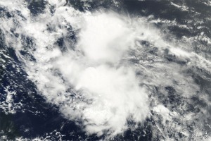
A natural-color image of Tropical Storm Colin captured by MODIS on NASA’s Terra on 9:40 a.m. EDT (13:40 UTC). Click image to enlarge.
Download large image (3 MB, JPEG)


Image shows the storm’s rainfall amounts, as measured by NASA’s TRMM, on August 2, 2010. Source: NASA. Click image to enlarge. Download large image (121 KB, JPEG)

Posted in Atlantic hurricane season, atlantic hurricanes 2010, environment, storm, Tropical Storm 04L, Tropical Storm Colin Satellite Images, tropical storms 2010 | Tagged: , , | 1 Comment »