UPDATE @ 13:00UTC – LEHAR has weakened to a tropical depression with winds of about 50km/h, bringing moderate rains as it made landfall near the city of Machilipatnam, officials said. NO significant damage expected.
Thousands in low-lying coastal areas evacuated as Cyclone LEHAR raced toward east India
LEHAR [“wave” in Hindi,] which was downgraded from its earlier classification as a “very severe” cyclone to cyclonic storm, was packing sustained winds of about 75km/h, gusting to about 95km/h, as of 02:30UTC on Thursday, November 28, 2013.
“We remain geared to evacuate around 250,000 people in seven districts as per our earlier plans,” said the vice chairman of India’s disaster management agency on Wednesday. “The evacuation will begin later tonight or even early tomorrow morning in some places based on local conditions, including the beginning of rainfall.”

Cyclonic Storm LEHAR – Water Vapor [FIRE-EARTH Enhancement] Satellite image – recorded at 01:30UTC on November 28, 2013. Original Image Source: CIMSS/SSEC/WISC.
Earlier Image recorded at 05:30UTC on November 27, 2013.

LEHAR – Water Vapor [FIRE-EARTH Enhancement] Satellite image – recorded at 05:30UTC on November 27, 2013. Original Image Source: CIMSS/SSEC/WISC.
![]()
LEHAR, the third significant storm to hit east India since October, is expected to cause more damage than Cyclone HELEN.
Cyclone HELEN struck the Andhra Pradesh coast last Friday, forcing thousands of evacuations, killing at least six people and causing significant damage to crops.
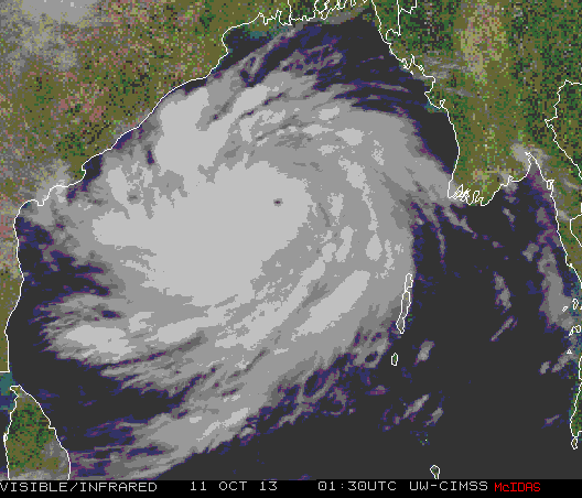
In October, Cyclone PHAILIN destroyed or damaged more than 500,000 mud houses, killing dozens of people, ruining 1.3 million hectares of crops and leaving more than 12 million homeless.
IMD Bulletin No.: BOB07/2013/34 [Dated: 28-11-2013 @ 5;00 IST]
The cyclonic storm ‘LEHAR’ over westcentral Bay of Bengal moved west-northwestward with a speed of 15kmph during past six hrs and lay centred at 02:30 hours IST of today, the 28th November 2013 over the westcentral Bay of Bengal near latitude 15.0ºN and longitude 83.5ºE, about 280 km east-southeast of Machillipatnam and 250 km south-southeast of Kakinada. It would move west-northwestwards, weaken further and cross Andhra Pradesh coast near Machillipatnam as a deep depression around today, the 28th November afternoon.
This post will be updated throughout the day …
Related Links
- LEHAR Closing in on Indian Coast November 27, 2013
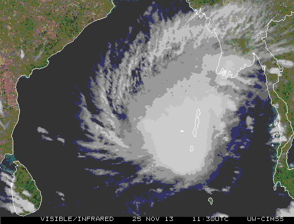
- Cyclonic Storm LEHAR Strikes Andaman Islands November 25, 2013
- Tropical Cyclone HELEN Striking East India Coast November 21, 2013
- FEWW New Hurricane Scale
- Satellite Imagery