Volcanic Activity Report: 29 July – 4 August 2009
VOW: Kizimen
55°08’ N, 160°20’ E, summit elevation 2,375 m

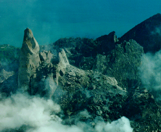
Kizimen volcano is a Holocene edifice situated in Shchapina graben, on the southeastern edge of the Central Kamchatka Depression. The volcano is cut by NE-strking faults and deep gullies, which expose the whole suite of its rocks. The only historic eruption of the volcano (“fire flames and black smoke”) was reported by local hunters in 1928, however, it should have been a weak one since no deposits of this age are seen at the foot of the volcano. Copyrighted photo by Vikto Dvigalo. Caption: Holocene Kamchataka volcanoes; http://www.kscnet.ru/ivs/volcanoes/holocene/main/main.htm
Kizimen is an isolated, conical stratovolcano that is morphologically similar to Mount St. Helens prior to its 1980 eruption. The summit of Kizimen consists of overlapping lava domes, and blocky lava flows descend the flanks of the volcano, which is the westernmost of a volcanic chain north of Kronotsky volcano. The 2376-m-high Kizimen was formed during four eruptive cycles beginning about 12,000 years ago and lasting 2000-3500 years. The largest eruptions took place about 10,000 and 8300-8400 years ago, and three periods of long-term lava dome growth have occurred. The latest eruptive cycle began about 3000 years ago with a large explosion and was followed by lava dome growth lasting intermittently about 1000 years. An explosive eruption about 1100 years ago produced a lateral blast and created a 1.0 x 0.7 km wide crater breached to the NE, inside which a small lava dome (the fourth at Kizimen) has grown. A single explosive eruption, during 1927-28, has been recorded in historical time. USGS
New activity/unrest:
Source: Global Volcanism Program (GVP) – SI/USGS Weekly Volcanic Activity Report
Notes:
On 2 August, KVERT reported that seismic activity from Kliuchevskoi had gradually increased since 30 July, and continuous seismic tremor was detected. A strong thermal anomaly was seen in satellite imagery at night.
On 31 July, KVERT reported that seismic activity from Kizimen had increased since 11 July. Several tens of shallow earthquakes per day were detected. (Source: GVP)
Ongoing Activity:
- Batu Tara, Komba Island (Indonesia)
- Chaitén, Southern Chile
- Colima, México
- Ebeko, Paramushir Island
- Fuego, Guatemala
- Galeras, Colombia
- Kilauea, Hawaii (USA)
- Nevado del Huila, Colombia
- Pacaya, Guatemala
- Rabaul, New Britain
- Sakura-jima, Kyushu
- Santa María, Guatemala
- Shiveluch, Central Kamchatka (Russia)
- Suwanose-jima, Ryukyu Islands (Japan)
Recent Kilauea Status Reports, Updates, and Information Releases
HAWAIIAN VOLCANO OBSERVATORY DAILY UPDATE Wednesday, August 5, 2009 7:39 AM HST (Wednesday, August 5, 2009 17:39 UTC)
KILAUEA VOLCANO (CAVW #1302-01-)
19°25’16” N 155°17’13” W, Summit Elevation 4091 ft (1247 m)
Current Aviation Color Code: ORANGE
Current Volcano Alert Level: WATCH
Activity Summary for past 24 hours: The Halema`uma`u Overlook vent remained dark; sulfur dioxide emission rates from Halema`uma`u and east rift zone vents were elevated; lava from the TEB vent, on the east rift zone, flows through tubes to the Waikupanaha ocean entry west of Kalapana; surface flows are active on the pali.
Past 24 hours at Kilauea summit: No lava or glow has been visible within the Halema`uma`u Overlook vent since the July 4 DI event. This morning, the plume is white and opaque and is blowing toward the southwest. Tephra production by the vent has been very low over the past several weeks, mostly characterized by ash-sized rock dust from small wall collapses in the vent. No rock falls or gas rushing sounds were heard at the vent during this morning’s ash collection. (HVO)
Related Links:
FEWW Links:
Global Volcanism, Volcanic Activity Report, Volcano Hazard, VolcanoWatch, volcanism, volcanoes. Tagged: Batu Tara, Kīlauea, Sakura-jima, Sarychev Peak, Suwanose-jima.


