
VolcanoWatch Weekly [2 July 2009]
Posted by feww on July 3, 2009
VoW: Yellowstone Volcano
Location: 44.43°N 110.67°W
Summit Elevation: 2,805 m
Volcano Alert Level: NORMAL
Aviation Color Code: GREEN

Remote sensor imagery of Yellowstone Caldera. Source: a frame-freeze picture from Yellowstone Volcano Due To Erupt

The rim of the Yellowstone Caldera. Source ESA (mirrored from http://www.yellowstonegis.utah.edu/home/home.html)
What’s brewing under the old rocks?
- Earthquake swarms are common at Yellowstone.
- Increased seismic activity at Yellowstone Lake in Yellowstone National Park in late December 2008 decreasing since January 8, 2009.
- Seismic activity could continue.
- The recent swarm is well above typical activity at Yellowstone, but not unprecedented.
- Earthquake swarms within the Yellowstone caldera typically occur with magnitudes of about 4.0.
- A swarm with about 3,000 events occurred in 1985 on the northwest rim of the caldera, lasting for three months, with largest earthquakes up to M4.9 recorded. (Source: Volcanoes USGS )

Yellowstone Lake showing location and times of the recent earthquakes from Dec. 27, 2008 (blue) to Jan. 8, 2009 (red). The M 3.0 and greater earthquakes are shown as stars, the smaller earthquakes are shown as circles. During the swarm, the earthquake locations appear to have moved north. For more information on the depths of the earthquakes, see the cross section from X to X’ below. (Source: Volcanoes USGS/ YVO )

The depth versus location of the Yellowstone Lake earthquake swarm from X to X’ on the Yellowstone Lake map. Earthquakes are shown from Dec. 27, 2008 (blue) to
Jan. 8, 2009 (red). The M 3.0 and greater earthquakes are shown as stars, the smaller earthquakes are shown as circles. (Source: Volcanoes USGS/ YVO )

Number of reviewed Yellowstone Lake earthquakes in six-hour and three-hour intervals from 12/27/08 to 01/06/09. The green line on the left figure gives the cumulative
number of earthquakes; the steep slopes correspond to increase in earthquake number. The red line in the figure on the right gives the cumulative moment, or energy; its sharp increase in the first few days is due to a greater number of large earthquakes with their greater energy release. The total cumulative moment is equivalent in energy to about one M 4.5 earthquake. Click on the image for a full-size version. (Source: Volcanoes USGS/ YVO )
What causes earthquakes at Yellowstone?
USGS / YVO cite a combination of geological factors including:
- Regional stress associated with normal faults such as the nearby Teton and Hebgen Lake faults
- Magmatic movements at depth (>7 kms)
- Hydrothermal fluid activity caused by boiling groundwater which is heated by magma.
However, YVO has not reported any anomalous changes in hot springs discharges, gas emissions …
In 2004 the Yellowstone caldera underwent period of accelerated uplift, clocking 7 cm/yr, or three times faster than in the recorded history; however the movement has now slowed down to a maximum rate of 4 cm/yr (or about 175 % of the pre-2004 records.)
The uplift is most noticeable at the White Lake GPS station, as has been discussed in our monthly YVO updates during the past year. As of late October 2007, the total uplift since 2004 at that location is about 17 cm. Chang and his colleagues credit the relatively rapid rise to recharge of magma into the giant magma chamber that underlies the Yellowstone Caldera. They also used numerical modeling to infer that the magma intruded about 10 km (6 miles) beneath the surface.

This interferogram provides a map view of ground movements at Yellowstone. Each color contour represents a line of equal uplift relative to the ENVISAT satellite between Sept. 2004 and Aug. 2006. The center of the uplift is an elliptical region stretching from the northeastern part of the Yellowstone Caldera (the dashed black line) to the southwest. This area of maximum uplift encompasses both Yellowstone’s resurgent domes, features long known for similar movements. During this time period, the north-rim uplift anomaly subsided (bullseye in the upper left part of the interferogram). The yellow lines are roads. The yellow triangles are locations of GPS stations with continuous data. The light blue lake within the caldera is Yellowstone Lake. Thin black lines are mapped faults. Figure courtesy of C. Wicks, USGS. Caption: USGS / YVO
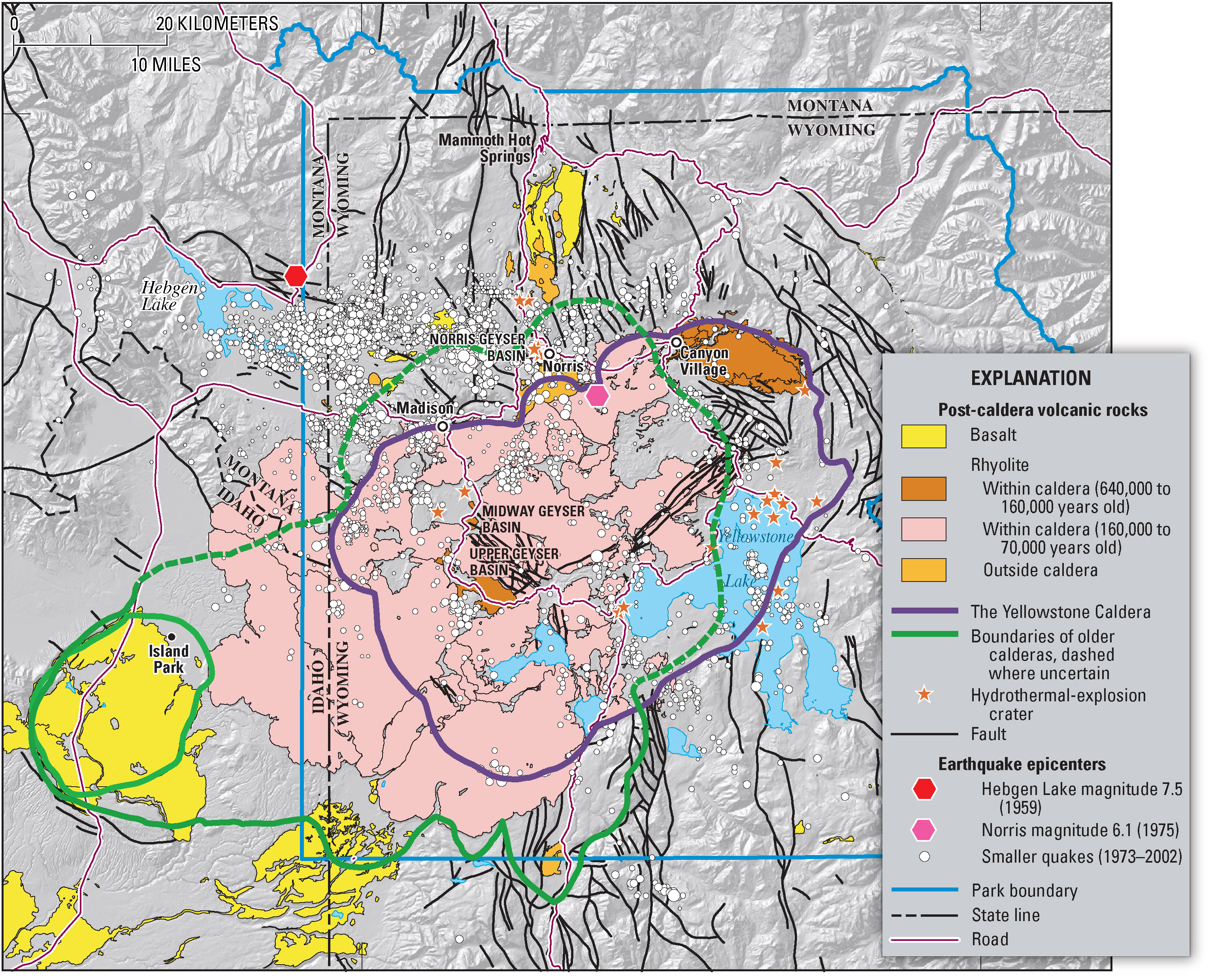
Yellowstone caldera Map. USGS Click Image to Enlarge.

Source: USGS

Source: Yellowstone National Park.
Conclusion:
USGS / YVO: “At this time, there is no reason to believe that magma has risen to a shallow level within the crust or that a volcanic eruption is likely. ”
FEWW: Perhaps, a new mindset is needed to help understand the true nature, “utility function” and full range of all possible scenarios that might occur at the super volcano site. Let’s start looking at Yellowstone in the Big Picture frame. There may be a few sobering “surprises” in store!
Volcanic Activity Report: 24 June-30 June 2009
Source: Global Volcanism program (GVP) – SI/USGS Weekly Volcanic Activity Report
New activity/unrest:
- Cleveland, Chuginadak Island
- Sarychev Peak, Matua Island
NOTE: A small explosive eruption of Cleveland on 25 June prompted AVO to raise the Volcano Alert Level to Watch and the Aviation Color Code to Orange. An ash cloud that detached from the volcano was seen on satellite imagery moving S at an estimated altitude of 4.6 km (15,000 ft) a.s.l. No further activity was reported. On 27 June, AVO lowered the Volcano Alert Level to Advisory and the Aviation Color Code to Yellow. (Source: GVP)
Ongoing Activity:
- Arenal, Costa Rica
- Bagana, Bougainville
- Batu Tara, Komba Island (Indonesia)
- Chaitén, Southern Chile
- Dukono, Halmahera
- Galeras, Colombia
- Kilauea, Hawaii
- Rabaul, New Britain
- Redoubt, Southwestern Alaska
- Sakura-jima, Kyushu
- Sangay, Ecuador
- Santa María, Guatemala
- Shiveluch, Central Kamchatka (Russia)
- Slamet, Central Java (Indonesia)
- Soufrière Hills, Montserrat
- Tungurahua, Ecuador
Latest U.S. Volcano Alerts and Updates for July 03, 2009 0040 UTC
-
Redoubt Activity – Color Code YELLOW : Alert Level ADVISORY
-
Kilauea Activity – Color Code ORANGE : Alert Level WATCH
-
Cleveland Activity – Color Code – YELLOW : Alert Level – ADVISORY
-
Mauna Loa Activity – Color Code YELLOW : Alert Level ADVISORY
Related Links:
- Volcanoes [FEWW Links]
- Earthquakes

feww said
The dailymail.co.uk wrote:
“Is the world’s largest super-volcano set to erupt for the first time in 600,000 years, wiping out two-thirds of the U.S.?”
“Two-thirds of the U.S. could become uninhabitable as toxic air sweeps through it, grounding thousands of flights and forcing millions to leave their homes.”
http://www.dailymail.co.uk/sciencetech/article-1350123/Worlds-largest-volcano-Yellowstone-National-Park-wipe-thirds-US.html
Message to “mail online”
1. Can you quote your source for the “two-thirds of the U.S.” estimate?
We’d be interested to know what sources other than this blog has made a similar analysis.
2. Do NOT exaggerate!
In https://feww.wordpress.com/2009/12/14/plumbing-that-feeds-the-yellowstone-supervolcano/
FIRE-EARTH Moderators forecast: “The next cataclysmic event at Yellowstone supervolcano could cover about 60 percent of the continental US in volcanic materials.”
feww said
Yellowstone eruption may cover 60 pct of US: FEWW
The next cataclysmic event at Yellowstone supervolcano could cover about 60 percent of the continental US in volcanic materials —Fire Earth