Fire Earth

Earth is fighting to stay alive. Mass dieoffs, triggered by anthropogenic assault and fallout of planetary defense systems offsetting the impact, could begin anytime!

Archive for the ‘US Storm Map’ Category

TORNADO WARNING

Posted by feww on May 1, 2011

MORE TORNADOES ON THE WAY 

NEW Severe Storms Possible Across Eastern North Texas This Evening

TORNADO WARNING

BULLETIN – EAS ACTIVATION REQUESTED TORNADO WARNING
NATIONAL WEATHER SERVICE SHREVEPORT LA — 9:02 PM CDT SAT APR 30, 2011

THE NATIONAL WEATHER SERVICE IN SHREVEPORT HAS ISSUED A

* TORNADO WARNING FOR
SOUTHEASTERN CAMP COUNTY IN NORTHEAST TEXAS
SOUTHWESTERN CASS COUNTY IN NORTHEAST TEXAS
MORRIS COUNTY IN NORTHEAST TEXAS
EXTREME SOUTHEASTERN TITUS COUNTY IN NORTHEAST TEXAS
NORTHEASTERN UPSHUR COUNTY IN NORTHEAST TEXAS

UNTIL 945 PM CDT

* AT 902 PM CDT, NATIONAL WEATHER SERVICE METEOROLOGISTS DETECTED A SEVERE THUNDERSTORM CAPABLE OF PRODUCING A TORNADO 2 MILES NORTHEAST OF HOLLY SPRING OR 11 MILES EAST OF PITTSBURG, MOVING NORTHEAST AT 20 MPH.

* OTHER LOCATIONS IN THE WARNING INCLUDE BUT ARE NOT LIMITED TO CASON, DAINGERFIELD, JENKINS, HUGHES SPRINGS, OMAHA, ROCKY BRANCH AND NAPLES

PRECAUTIONARY/PREPAREDNESS ACTIONS

IN ADDITION TO THE TORNADO THIS STORM IS CAPABLE OF PRODUCING QUARTER TO GOLFBALL SIZE HAIL AND DESTRUCTIVE STRAIGHT LINE WINDS.

TREES HAVE BEEN DOWNED IN NORTHERN UPSHUR COUNTY WITH THIS STORM. IF YOU ARE ITS PATH,

TAKE COVER NOW!

RELATED WARNINGS

U.S. Weather Hazard Map May 1 UTC


Click image to enter NWS portal.

Weather Forecast Map

Click images to enlarge.

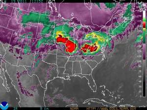
GOES Eastern US SECTOR Infrared Image


Posted in US Storm Map, US storms | Tagged: , , , , , | Leave a Comment »

Tornado Record for April Smashed

Posted by feww on April 27, 2011

295 Confirmed April Tornadoes So Far

April 2011 Tornadoes Smash Record 267 Tornadoes Set in 1974

With 3.5 more days to go, some 295 confirmed tornadoes have wreaked havoc in the United States this month, causing death and destruction in dozens of states.

The Storm Prediction Center (SPC) has received a total of 6,559 reports (LT average ~ 3,300) of sever weather reports this month, as of Tuesday April 26. 2011 @ 20:18CT

  • Tornadoes: 654
  • Hail: 2,725
  • High/Damaging Winds:  3,180
  • TOTAL: 6,559

In one of the latest incidents, a tornado touched down about 75 miles east of Dallas near the E. Texas town of Edom, destroying/damaging at least 100 homes.

“We have major destruction,” said Chuck Allen, Van Zandt County emergency management spokesman. “We have multiple houses damaged or destroyed … easily 100-plus.”

As the storm moved on toward Central Texas, it spawned about 20 tornadoes, reports said.

April also saw the first EF4  tornado for the year, which leveled the St. Louis suburb of Bridgeton. [Also the first EF4 tornado in metro area since Jan. 24, 1967. ]


Click image to enlarge. Click here for details.

Hazard Warnings

Tornado Headlines

Related Links

Posted in storm disaster, US Storm Map | Tagged: , , , , , | Leave a Comment »

Severe Thunderstorms Brewing

Posted by feww on April 19, 2011

US Weather Update

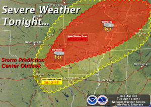
Severe thunderstorms forecast for parts of the Ozarks, the lower and middle Mississippi Valleys, and the lower Ohio Valley later today through tonight: NWS

Tornadoes, damaging winds and large hail developing in the Ozarks will move  into parts of Mississippi and lower Ohio Valleys later today through tonight: NWS Storm Prediction Center forecasts

Most likely target areas:

  • Northern And Western Arkansas
  • Central And Southern Illinois
  • Central And Southern Indiana
  • Western And Northern Kentucky
  • Southern And Eastern Missouri
  • Western Ohio
  •  Eastern Oklahoma
  • Northwest Tennessee

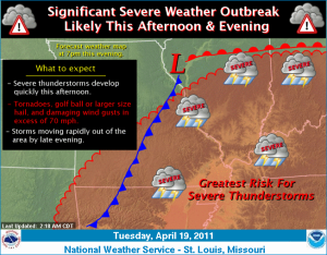
Severe Weather Forecast Map


Click image to enlarge. Click HERE to update

See earlier entry at

GOES Eastern US SECTOR Infrared Image 

Image of the Day: The Angry Storm Face


Click image to enlarge. Click HERE to update


‘Severe thunderstorms are expected to rapidly develop over Missouri and Illinois this afternoon and spread quickly east this evening. The strongest storms will be capable of producing tornadoes, golf ball or larger size hail, and damaging straight line wind gusts in excess of 70 mph. Locally heavy rainfall is also possible. The storms are expected to exit the region to the east by late evening.’ NWS said.


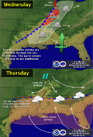
“A cold front will move into the area on Wednesday and bring a good chance for thunderstorms.  Some of these storms could be strong to severe, but the better chance for more organized severe thunderstorms will be to the northwest of our area. The front will stall in our area on Thursday, with the possibility for showers and thunderstorms lingering through the period and perhaps into the weekend,” NWS said.

More information available at NWS …

Related Links

Posted in National Weather Forecast, US Storm Map, US storms, us weather forecast, US Weather Map | Tagged: , , , , , | Leave a Comment »

U.S. Tornado Outbreak – Update 19 April

Posted by feww on April 19, 2011

More severe weather expected Tuesday

U.S. Tornadoes kill at least 58 in East, South since Thursday

The weekend tornado outbreak killed 45 people and destroyed many homes and businesses in the East and South, NWS reported. Severe thunderstorms are forecast in the Southeast again Tuesday.

[NOTE: SPC reported 45 fatalities for the weekend. FIRE-EARTH has added 13 other fatalities reported on SPC website for Thursday, April 14.]


Weekend Tornadoes: Alabama, Arkansas, Georgia, Illinois, Louisiana, Maryland, Mississippi, Missouri, North Carolina and Virginia.

Weekend Death Toll

  • North Carolina: 22
  • Alabama: 7
  • Arkansas: 7
  • Virginia: 6
  • Oklahoma: 2
  • Mississippi: 1

Thursday’s Death Toll

  • Alabama: 2
  • Arkansas: 8
  • Louisiana: 1
  • Oklahoma: 2

Severe Weather report Summary

“Forecasters said a disturbance moving from the Midwest this morning could account for minor snow accumulations across southern Michigan into northwest New York by tonight. Largely-scattered rain and higher elevation snow showers are expected to move into the Plains and the Midwest tonight into Tuesday. This system is forecast to produce a substantial outbreak of thunderstorms and possibly severe weather from the southern Plains into the Ohio Valley. Potentially heavy rain will impact already-elevated river levels.” NWS reported.

Severe Weather Stats:

Severe Weather Map


Click image to enlarge.

GOES Eastern US SECTOR Infrared Image


Eastern Conus Sector (Infrared Channel). Click image to enlarge. Click HERE to update.

“A large area of the Midwest, central Plains and the Southeast will be at slight risk for severe weather development Tuesday with a core area at Moderate Risk,” Storm Prediction Center forecasters said.

The 7-state area at Moderate Risk

Parts of Missouri, northern Arkansas, the southern two-thirds of Illinois, all of Indiana except the northern quarter, extreme SW Ohio, W. and N. Kentucky and extreme NW Tennessee.

The 18-state area at Slight Risk
Parts of Nebraska, Missouri, Kansas, Oklahoma, Texas, Arkansas, Louisiana, Illinois, Indiana, Ohio, Kentucky, Tennessee, Mississippi, Michigan, Alabama, Pennsylvania, New York and West Virginia, SPC said.

Flooding

“Main-stem river flooding continues throughout the northern Plains and along parts of the Missouri and Mississippi River drainages.”

From: 2011 Disaster Calendar – April

Related Links

Posted in Tornado forecast, US Storm Map, US storms, us weather forecast, US Weather Map | Tagged: , , , | Leave a Comment »