Fire Earth

Earth is fighting to stay alive. Mass dieoffs, triggered by anthropogenic assault and fallout of planetary defense systems offsetting the impact, could begin anytime!

Archive for the ‘National Weather Forecast’ Category

US Severe Weather Forecast: Missouri in Crosshairs

Posted by feww on April 22, 2011

Present significant severe weather danger for the Mississippi, Missouri and Ohio River valleys: NWS

Many rivers in the Plains and Midwest already at flood levels could receive up to 5 inches of rain by early next week, forecasters say. Flooding is forecast for  parts of the northern Plains, the Midwest, the Great Lakes and the Ohio Valley.
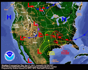
Today’s forecast:

  • Possible severe weather in the southern Plains
  • Rain and thunderstorms in the Mountain West, the Four Corners area, the Southeast and the southern Atlantic Coast
  • Heavy snow in western Montana, north-central Idaho and western Wyoming

“Most of Missouri is at the center of a double weather whammy, sitting in the center of severe weather forecasts for tonight and Friday and at the core of heavy rains forecast into next week.” NWS reported.


Weather Forecast Map. Click images to enlarge.


Weather Outlook (Probabilistic)

 Rainfall Forecast:The 5-day total  

Texas Wildfires

Report: Wednesday Close, April 21, 2011

  • National Preparedness Level: 1
  • Southern Area Preparedness Level: 3
  • TFS Preparedness Level: 5

Texas Fires YTD Totals

  • Fires: 6,061 [4 new fires]
  • Acres Burned: 1,821,086
  • Structures Destroyed: 859
  • Source: Texas Forest Service (TFS)

Drought and Heat: Recipe for Deadly Fire Conditions in Texas


Image shows ground temperatures differentials for April 7 to April 14 compared to long-term average for that week.  Data for the image gathered by MODIS on NASA’s Terra satellite. Drought and high temperatures are clearly contributing to the deadly fire conditions in Texas. Source: NASA-EO
Fatalities
Two firefighters have lost their lives, including one near Lubbock who was killed yesterday
Two sightseers were killed as their plance  circled over fires Tuesday.

Livestock
NO official figures have been released so far. However,  FIRE-EARTH estimates that up to 20,000 heads of cattle may have been killed or injured as a result of the deadly fires since beginning of the year.

Posted in extreme weather, National Weather Forecast, National Weather Warnings | Tagged: , , , , , , | Leave a Comment »

Severe Thunderstorms Brewing

Posted by feww on April 19, 2011

US Weather Update

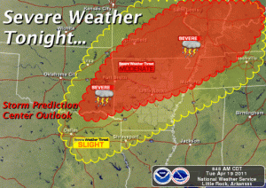
Severe thunderstorms forecast for parts of the Ozarks, the lower and middle Mississippi Valleys, and the lower Ohio Valley later today through tonight: NWS

Tornadoes, damaging winds and large hail developing in the Ozarks will move  into parts of Mississippi and lower Ohio Valleys later today through tonight: NWS Storm Prediction Center forecasts

Most likely target areas:

  • Northern And Western Arkansas
  • Central And Southern Illinois
  • Central And Southern Indiana
  • Western And Northern Kentucky
  • Southern And Eastern Missouri
  • Western Ohio
  •  Eastern Oklahoma
  • Northwest Tennessee

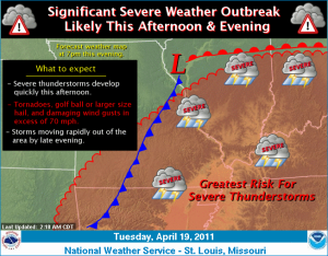
Severe Weather Forecast Map


Click image to enlarge. Click HERE to update

See earlier entry at

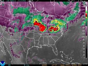
GOES Eastern US SECTOR Infrared Image 

Image of the Day: The Angry Storm Face


Click image to enlarge. Click HERE to update


‘Severe thunderstorms are expected to rapidly develop over Missouri and Illinois this afternoon and spread quickly east this evening. The strongest storms will be capable of producing tornadoes, golf ball or larger size hail, and damaging straight line wind gusts in excess of 70 mph. Locally heavy rainfall is also possible. The storms are expected to exit the region to the east by late evening.’ NWS said.


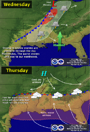
“A cold front will move into the area on Wednesday and bring a good chance for thunderstorms.  Some of these storms could be strong to severe, but the better chance for more organized severe thunderstorms will be to the northwest of our area. The front will stall in our area on Thursday, with the possibility for showers and thunderstorms lingering through the period and perhaps into the weekend,” NWS said.

More information available at NWS …

Related Links

Posted in National Weather Forecast, US Storm Map, US storms, us weather forecast, US Weather Map | Tagged: , , , , , | Leave a Comment »

U.S. Climate: Warming Trend Continues

Posted by feww on April 10, 2011

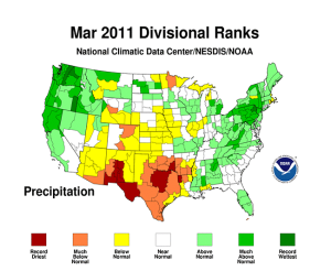
U.S. had above normal temperatures and precipitation in March: NOAA

March temperatures and precipitation in the contiguous United States averaged above normal, according to NOAA.

  • The average temperature in March:  44.0ºF
  • Long term average (1901-2000) temps: 42.6ºF

March precipitation, save for record dry in Texas and other areas in the south and southwest, was 0.22 inch above the long-term average.

January to  March

  • Average Temps: Near-normal
  • Average Precipitation: Below-normal


Source: NOAA. Click images to enlarge.

Posted in Climate Change, climate warming trend, National Weather Forecast, US Precipitation Map, US rainfall, US temperature, US Temperature map | Tagged: , , | Leave a Comment »

US Weather Forecast: Thunderstorms, Strong Winds, Flooding, Fire

Posted by feww on April 5, 2011

Severe weather forecast for much of the U.S.


Click image to enter NWS portal.


Low pressure system over Chicago with cold front to Dallas moving east

  • Risk of severe weather in conjunction with thunderstorms
  • “A second storm moving onshore over the Pacific Northwest will move to the Upper Mississippi Valley by Tuesday evening. High elevation snow and low elevation rain will move into parts of the northern High Plains, northern and central Rockies on Tuesday.”

A large area of the Southeast and Midwest at risk of severe weather

  • Primary target: Parts of Arkansas, Tennessee, Louisiana, Mississippi and Alabama.
  • Secondary target:  All or parts of Oklahoma, Texas, Missouri, Arkansas, Louisiana, Illinois, Indiana, Kentucky, Tennessee, Alabama, Ohio, Pennsylvania, Virginia, West Virginia, North Carolina, South Carolina, Georgia and the Florida Panhandle.
“Parts of the risk area and the central Plains area have also been alerted to driving problems from high winds that will dominate the Plains and the Southeast.
“Forecasters said winds would range from 15-25 mph with gusts to 35-40 mph to areas of 30-35 mph winds gusting to around 50 mph, to sustained winds of 45-55 mph with gusts to 75 mph in western Wyoming. High winds will cause difficulties in South Dakota, Nebraska, Kansas, Oklahoma, Texas, Minnesota, Iowa, Missouri, Arkansas, Louisiana, Illinois, Indiana, Ohio, Kentucky, Tennessee, Mississippi, Alabama, Georgia, West Virginia, Virginia, North Carolina and South Carolina.”

Wildfires:

“Officials hope to avoid a repeat of the wildfire outbreak experienced Sunday in New Mexico, Oklahoma, Texas, Colorado and Kansas. Wildfire details included:
  • Colorado – Baca County fire near Walsh burned only 30 acres but burned into Walsh and forced evacuation of 120 homes, contained Sunday evening; Crystal Wildland Fire in Larimer County burned approximately 4,500 acres and is 5 percent contained
  • New Mexico – White Fire near Ruidoso burned 2,000-3,000 acres and destroyed at least 4 homes
  • Kansas – Grassland wildfire in Grant Haskell and Stevens counties burned approximately 9,000 acres, 3 homes destroyed, 100 percent contained in Grant County, 70 percent in Stevens County and 80 percent in Haskell County
  • Oklahoma – Guymon Fire burned 7,500 acres and destroyed 12 homes
  • Texas – Fire near Midland burned 500 acres and threatened houses and oil field equipment; Justiceberg fire in Garza County burned 2,000 acres, threatens more than 20 homes; Bates field fire in Ector County burned 2,500 acres but no structures lost, evacuees being allowed to return; smaller fires included Willow View fire in Hardeman County, South Road fire in Yoakum County and Rancho Real fire in Real County.” [Drought Information Update: Drought worsens with limited precipitation in March]

Flooding

NOAA’s Advanced Hydrologic Prediction Service showed 111 gauge sites at some level of flooding.

  • 13 sites were at Major Flood levels,
  • 23 sites at Moderate Flood
  • 75 sites at Minor Flood

Additionally

  • 109 sites were at Near Flood

Major flooding is occurring on Devils Lake, Stump Lake, The James River, the Wild Rice River, the Minnesota River, the Cottonwood River and the Mississippi River. Details available at http://water.weather.gov/ahps/index.php?stage=7

Related Links

Posted in National Weather Forecast, weather chaos, weather forecast | Tagged: , , , , , , , | Leave a Comment »

US Severe Weather Forecast: T-Storms, Tornadoes

Posted by feww on April 4, 2011

Tornadoes Could Torpedo Tornado Alley

Arkansas

Texas

Related Links

Posted in National Weather Forecast, weather chaos, weather forecast | Tagged: , , , , , , | Leave a Comment »

Red Flag Warnings in Seven States

Posted by feww on April 3, 2011

Strong Winds Sunday & Severe Weather Possibilities: NWS

Strong winds and low relative humidity prompts National Weather Service to issue Red Flag Warnings in at least 7 states:  Arizona, Colorado, Kansas, Kentucky, New Mexico, Oklahoma and Texas.

Check map also for flood warnings.


Click map to enter BWS portal.

Nine tornadoes tore through the Tampa Bay area

NWS has confirmed that at least 9 tornadoes tore through the Tampa Bay area, three each in Polk, Hillsborough and Pinellas counties, as  a strong weather front moved through the area three days ago.

“Substantial damage occurred in the Palm River, Riverview and Interbay Boulevard areas, where the weather service said two tornadoes touched down in a 10-minute period.” Said a report.

About 87,000 customers lost power during the storm. “Some of the homes and businesses were so severely damaged that even if we restore a neighborhood, the customer has problems receiving the power,” a TECO spokesman said.

Record High Temperatures Across Northern & Central New Mexico

NWS has reoported the following preliminary temperatures for NM on Saturday April 2.

LOCATION                    NEW RECORD        OLD RECORD

ALBUQUERQUE SUNPORT             83              82/1966
FARMINGTON AIRPORT              80              75/1966
CHAMA                           70              66/2002
LOS ALAMOS                      75              72/2002
DULCE                           73              72/2002
SANTA FE                        77              74/2002
CLAYTON AIRPARK                 86              84/1946
GALLUP AIRPORT                  76              75/2002
TUCUMCARI AIRPORT               91              90/1946
RUIDOSO AIRPORT                 75              72/1967
ROSWELL AIRPORT                 95              90/1966
CLOVIS                          90              89/1943

Severe Weather Pounds North and Central Georgia

(March 26-27, 2011)

A complex storm system tracked from Texas into the Mississippi River Valley and across Georgia on March 26 and 27 bringing severe weather to north and central Georgia. More…


Large Hail fell in Moreland (Coweta County), GA. Credit: NWS. Click image to enlarge.

An EF-1 tornado tracked across Laurens County with maximum winds estimate at 90 MPH and a maximum path width of 500 yards. It touched down around 9:40 PM EST about 1.8 miles west of Brewton and traveled east approximately 3.5 miles before lifting. Hundreds of trees were snapped or downed and about 30 structures were damaged, More …


Path of EF-1 tornado that struck Brewton in Laurens County, GA. Credit: NWS

Related Links

Posted in National Weather Forecast, US Wildfire, weather forecast | Tagged: , , , , , , | Leave a Comment »

U-S: Risk of Severe Thunderstorms

Posted by feww on February 25, 2011

Another Red Flag Warnings Day!

Moderate Risk of Severe Thunderstorms Today: NWS

The NWS Storm Prediction Center has issued a moderate risk for severe thunderstorms for today over parts of the lower Mississippi and lower Tennessee Valleys. The areas most likely to experience this activity include much of Arkansas, western Kentucky, northern Mississippi, and western and middle Tennessee. The storms will have the potential to grow into one or more long-lived bands that could produce a few strong tornadoes in addition to swaths of damaging wind and hail. Details…

National Weather Warnings


Click image to enter NWS portal.

Weather Forecast Map – NOAA


Click image to enlarge.

Predominant Weather


Click image to update.

Related Blog Pages


Posted in National Weather Forecast, National Weather Warnings, weather forecast feb 25, Weather Forecast Map | Tagged: , , , , , | Leave a Comment »