Fire Earth

Earth is fighting to stay alive. Mass dieoffs, triggered by anthropogenic assault and fallout of planetary defense systems offsetting the impact, could begin anytime!

Archive for April 20th, 2010

Eyjafjallajökull Erupting – UPDATE: 20 Apr

Posted by feww on April 20, 2010

Considerable volcanic activity is occurring at three separate craters at Eyjafjallajökull, with explosions heard continually

Plume of ash is reaching a height of about 6,000m asl. The ash is accumulating around the edge of the craters and is beginning to form a rim. Lava splatters were earlier ejected to a height of about 3 km this morning.

The visibility in the vicinity of Eyjafjoll and at Asolfsskali var was reported at 500 meters, about two hours ago (~ 07:00UTC).

“There is no risk of flash floods because the water is continuously flowing off the glacier.” Local experts said.

Iceland Met Office  (IMO) – Update on activity
Eruption in Eyjafjallajökull, Iceland
Sound blasts – 20 April 2010 at 12:30(UTC)

Heavy sound blasts have been heard and found near Eyjafjallajökull, especially south and east of the mountain, and more clearly after wind speeds became lower. Possible explanation: Very hot gases rise from the eruptive channel. When surfaced, the temperature of the gases drops sharply with abrupt changes in pressure. These result in shock- and sound waves which can be carried long distances in air. END.

Volcanic Ash Drift from Iceland’s Eyjafjallajökull Eruption

This image uses infrared data from the Meteosat Second Generation (MSG) satellite to generate a false colour composite image. This presents information about the infrared radiation being emitted by the ash plume, and by surrounding clouds, at several different wavelengths. Because cloud particles and volcanic ash particles interact with the infrared radiation in different ways, they show up as different colours when the data are presented in this way (but it is important to note that these are false colour images, and the colours do not correspond to the actual colours that would be seen by the human eye). Please refer to the forecaster blog to read the latest information regarding the evolution of the plume. Caption: UK Met Office

How Bad is the Ash Drift in the UK?

A spokesman for UK’s National Air Traffic Service (NATS) said: “The volcano eruption in Iceland has strengthened and a new ash cloud is spreading south and east towards the UK. This demonstrates the dynamic and rapidly changing conditions in which we are working.  Latest information from the Met Office shows that the situation is worsening in some areas.”

Latest Eruption Images from the Webcams – Click images to enlarge

Eyjafjallajökull seen from Hvolsvelli

Eyjafjallajökull seen from Thórólfsfelli

Eyjafjallajökull seen from Valahnúk

Image of Ash from Eyjafjallajökull by NASA’s MODIS

Large plume of ash and fumes is seen spewing out of the volcano’s craters.

Eyjafjallajökull Captured by ALI on NASA’s EO-1 satellite

Download large image (2 MB, JPEG)

Ash Drift Graphics Issued by Volcanic Ash Advisory London, UK

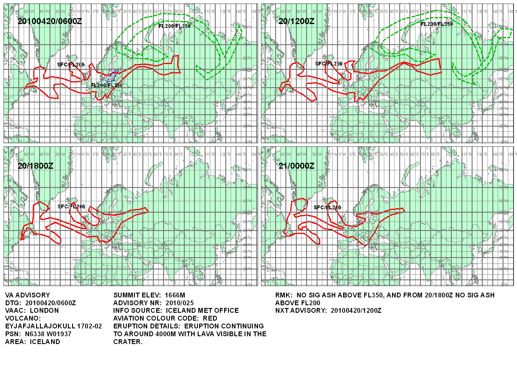
Animation of an Advisory Chart

This is an illustration of volcanic ash dispersion up to 20,000 ft, issued at 7 am (06:00UTC) on 20 April. Advisory charts are issued every six hours, for up to 18 hours ahead, by the Volcanic Ash Advisory Center, London, UK.

Polar Orbiter Imagery

These images show the progression of the main volcanic ash plume from Eyjafjallajökull on April 15, as detected using data from polar orbiting satellites operated by NOAA and EUMETSAT. As with the MSG images, these make use of the varying properties of the ash particles at different wavelengths. The ash cloud signal is yellow and orange in this sequence. The early images are able to detect only a very narrow section of plume close to the Icelandic coast, mainly because of the presence of higher-level ice clouds which are obscuring much of the ash below. Succeeding images show the ash plume developing more clearly as it spreads eastwards. Caption: UK Met Office.

Cross-Sectional Diagrammatic Representation of What Eyjafjallajökull and Katla might look like

For more information email Páll Einarsson (palli@raunvis.hi.is)

Insight into the eruption of Eyjafjallajökull from GPS data – Sigrún Hreinsdóttir and Þóra Árnadóttir [Source: Institute of Earth Sciences- NVC]

20. April 2010: Latest results from GPS stations around Eyjafjallajökull show deflation associated with the eruption. No movements associated with the Katla volcano are presently observed – Benedikt Ófeigsson and Bryndís Brandsdóttir

In the first two days of the Eyjafjallajokull volcano summit eruption (14. April), two GPS stations located north (STE2) and south (THEY) of the summit crater moved rapidly toward the eruption site (about 6 cm contraction between stations). Modeling of the GPS data suggest deformation due to a volume change of a shallow magma source (1 km depth). This is consistent with chemical analysis of the magma erupted, intermediate chemical composition (58 wt% silica) (Níels Óskarsson). The volume decrease estimated from the GPS data (3-10 million cupic m) is however only a small portion of the volume estimated to have erupted in the first few days (Magnús Tumi Guðmundsson et al.). GPS stations around Eyjafjallajokull volcano (http://notendur.hi.is/runa/eyja_gps.html) show continued deflation of the region, but now at a much slower rate at the stations closest to the summit. This could indicate continued deflation of another and deeper magma source.

Volume of erupted material and magma discharge for the first 72 hours

The Institute of Earth Sciences has now made a preliminary estimate of erupted material in the first three days of the eruption at Eyjafjallajökull. The erupted products are fragmented material, the majority fine-grained airborne tephra. Eruptive products can be split into three categories:
1. Material (tephra) in the ice cauldrons around the volcanic vents.
2. Tephra filling the glacial lagoon of Gígjökulslón, carried by floods down the outlet glacier Gígjökull.
3. Airborne tephra that has been carried to the east and south of the volcano (see memo by Thorvaldur Thordarson, Guðrún Larsen and Ármann Höskuldsson, pdf-file)

The preliminary results are as follows:
Tephra in ice cauldrons 30 Million m³
Tephra in Gígjökull lagoon 10 Million m³
Tephra fallout from eruption plume 100 Million m³
Total: 140 Million m³

The tephra is uncompacted, these values corresponds to some 70-80 Million m³ of magma. The average magma discharge rate is about 300 m³/s or 750 tonnes/s.
This is 10-20 times the averge discharge rate in the preceeding flank eruption at Fimmvörðuháls.

Magnús Tumi Guðmundsson; Þorvaldur Þórðarson; Guðrún Larsen; Ármann Höskuldsson; Þórdís Högnadóttir; Eyjólfur Magnússon
[Source: Institute of Earth Sciences- NVC]

How fine is the ash?

After the ashfall in the 14-16 April eruption, the Environment Agency collected samples  from Mýrdalssandur (50 km away from the eruption site), which were then  analyzed by Institute of Earth Sciences . The ash had a high fluorine content and was fine grained in the follows composition:

  • 24% of the sample was smaller than 10 μm (aerosol)
  • 33% of the sample measured 10-50 μm
  • 20% of the sample measured  50-146 μm
  • 23% of the sample measured 146-294 μm
  • Source: IMO

Related Links:

Serial No 1,598. Starting April 2010, each entry on this blog has a unique serial number. If any of the numbers are missing, it may mean that the corresponding entry has been blocked by Google/the authorities in your country. Please drop us a line if you detect any anomaly/missing number(s).

Posted in eyjafjallajoekull volcano, Iceland volcano, Thórólfsfelli, Valahnúk, volcano | Tagged: , , , , , , | 1 Comment »

Iceland’s Bárdarbunga May Be Erupting

Posted by feww on April 20, 2010

Fire Earth Moderators Believe Iceland’s Bárdarbunga May Be Erupting or is about to Erupt.

If our long-distance assessment is correct, the next eruption at Bárdarbunga/ Grímsvötn or any of the other 6 volcanoes listed below could spell a major disaster for Iceland.

Iceland seismic record for the past 48 hours shows 7  separate cluster of quakes in the vicinity of the following volcanoes (See image below)

  1. Kolbeinsey ridge (Last erupted: 1999)
  2. Krafla (1984)/ Theistareykjarbunga (< 1000 BC)/ Tjörnes fracture zone (1868)
  3. Askja (1961)
  4. Bárðarbunga (1903) and neighboring Grímsvötn (2004)
  5. Grímsnes (> 3500 BC)
  6. Reykjanes (1879)
  7. Eyjafjallajökull (Currently ongoing)

Bárdarbunga, one of the most active volcanoes in Iceland, is a massive volcano with a  700-m-deep caldera which lies beneath the NW Vatnajökull icecap.  A fissure eruption at Thjorsarhraun produced about 21 km³ of lava, the largest known Holocene lava flow on the planet.

Powerful eruptions may occur among the volcanoes lying along the Mid-Atlantic Ridge. The plate tectonics could also translate into increased seismicity along the divergent plate boundary and boundaries of neighboring plates.


Source: Iceland Met Office. © Veðurstofa Íslands


Original Caption:  Map showing the Mid-Atlantic Ridge splitting Iceland and separating the North American and Eurasian Plates. The map also shows Reykjavik, the capital of Iceland, the Thingvellir area, and the locations of some of Iceland’s active volcanoes (red triangles), including Krafla.

The consequences of plate movement are easy to see around Krafla Volcano, in the northeastern part of Iceland. Here, existing ground cracks have widened and new ones appear every few months. From 1975 to 1984, numerous episodes of rifting (surface cracking) took place along the Krafla fissure zone. Some of these rifting events were accompanied by volcanic activity; the ground would gradually rise 1-2 m before abruptly dropping, signaling an impending eruption. Between 1975 and 1984, the displacements caused by rifting totaled about 7 m.  Source: USGS.


Original Caption: Aerial view of the area around Thingvellir, Iceland, showing a fissure zone (in shadow) that is an on-land exposure of the Mid-Atlantic Ridge. Right of the fissure, the North American Plate is pulling westward away from the Eurasian Plate (left of fissure). This photograph encompasses the historical tourist area of Thingvellir, the site of Iceland’s first parliament, called the Althing, founded around the year A.D. 930. Large building (upper center) is a hotel for visitors. (Photograph by Oddur Sigurdsson, National Energy Authority, Iceland. Source: USGS.

Continued …

Related Links – Fire-Earth entries on Eyjafjallajökull and other useful  sources:

.

Serial No 1,597. Starting April 2010, each entry on this blog has a unique serial number. If any of the numbers are missing, it may mean that the corresponding entry has been blocked by Google/the authorities in your country. Please drop us a line if you detect any anomaly/missing number(s).

Posted in Bárdarbunga volcano, Mid-Atlantic Ridge, North American plate, rifting, Thingvellir | Tagged: , , , , | 15 Comments »

Eyjafjallajökull Ejects ‘Lava Lumps’

Posted by feww on April 20, 2010

Eruption at the Eyjafjallajökull

Eyjafjallajökull has been ejecting “lumps of lava”  from the volcano crater in the glacier in the past few hours, local geo-scientists have reported.


The Electric
Eyjafjallajökull. Date and photographer unknown. Image may be subject to copyright. Click Source for more photos. Click image to enlarge.


A column of ash steam and fumes rises above one of the three main craters at Eyjafjallajokull glacier. April 19, 2010. Soiurce: Reuters/Jon Gustafsson/Helicopter.is/Handout.

Meanwhile, Icelandic Meteorological Office reported that ashfall in the capital Reykjavik was unlikely. The risk is mitigated by easterly wind, blowing the ash away from the capital area, and rain forecast which could reduce the risk of ashfall.

Direct observations of Eyjafjallajökull showed  that lave was being splattered out of the volcano. The volcanic plume reached a height of about 3,000m (10000 feet), peaking to about 5,200m (17000 feet).

The local experts reported the plume as being  mostly white, “but with very dark pillars of smoke” blending in. “According to the Icelandic Meteorological Office website, the plume rose up to 4000 meters at 8:50 this morning. A lower plume indicates that water cannot enter the crater and that lava has begun to flow into it.”A report said.

There was no report of lava flows from the volcano, as of posting.

Ash Cloud Over Europe

Weather patterns continue to blow vast pockets of ash towards the UK and Ireland.

The UK Met Office, which is the North-west European Volcanic Ash Advisory Centre with responsibility for issuing the Volcanic Ash Advisories for volcanoes erupting in this area, said their priority and role is provide information that would support decision-making by NATS, CAA and other aviation authorities .

“It is for the aviation industry and regulator to set thresholds for safe ash ingestion. Currently, world-wide advice from ICAO is based on engine and airframe manufacturers stating that aircraft should not be exposed to any volcanic ash.” It said.


Shades of orange represent the volcanic ash in the atmosphere. © Copyright EUMETSAT/Met Office. Click image to enlarge.


The above is an illustration of volcanic ash dispersion up to 20,000 ft, issued at 7 am on 19 April. Advisory charts are issued every six hours, for up to 18 hours ahead, by the Volcanic Ash Advisory Center.


Volcanic Ash Advisory Graphics from London Met Office. Image may be subject to copyright. Click image to enlarge.

Ash cloud from Eyjafjallajökull reached  Canada’s Eastern seaboard

“The ash cloud is very diffuse, moving slowly and should not affect Canadian airports,” said an Environment Canada spokeswoman.

A forecaster at UK’s Met Office said it was unlikely that the ash would drift much further into North America.

“It is just skirting into the Newfoundland area over the next 12 to 18 hours. It doesn’t look as if it is going to get much further west than that, just on the coast and a little further inland.” He said.

Newfoundland is the closest tip of North America to Iceland.

Photo Links:

Related Links – Fire-Earth entries on Eyjafjallajökull and other useful  sources:

Serial No 1,596. Starting April 2010, each entry on this blog has a unique serial number. If any of the numbers are missing, it may mean that the corresponding entry has been blocked by Google/the authorities in your country. Please drop us a line if you detect any anomaly/missing number(s).

Posted in Eyjafjallajökull, Eyjafjallajökull eruption, Iceland volcano | Tagged: , , , | 1 Comment »

Afghanistan Quake, Leaves 100 Dead and Injured

Posted by feww on April 20, 2010

M5.6 Earthquake Strikes Afghanistan Killing about a dozen people and injuring dozens more.

The quake was centered at 35.669°N, 67.653°E and struck at a depth of about 10km on April 18, 2010 at 20:28:50 UTC. The Moderators expected some casualties as a result of the quake, but there was no immediate news of casualties or damage available initially.

“The villages were destroyed and the local routes were blocked from slipping mountain rocks on to the roads,” said Hajji Ghulam Sakhi Baghlani, the provincial assistant governor, UPI reported.

The death toll could rise as more people could be buried under the rubble of collapsed buildings, he said.

According to another report hundreds of livestock had perished as a result of the quake which also left 300 homes damaged.

The area where this quake occurred is close to Afghanistan’s Hindu Kush Mountains, which is earthquake-prone. NATO bombardment in the region, past and present, could trigger more violent quakes.

10-degree Map Centered at 35°N,70°E


Location Map. Source: USGS/EHP.Click image to enlarge.

Seismic Hazard Map


Major Tectonic Boundaries: Subduction Zones -purple, Ridges -red and Transform Faults -green. Source: USGS/EHP.

Felt Reports: Felt (IV) at Mazar-e Sharif. Felt (II) at Kabul and Dushanbe, Tajikistan. Also felt at Baghlan, Bagrami, Bamian, Baraki Barak, Gaz Aab, Pangabv, SHebergan and Sahrak, USGS/EHP said.

Earthquake Details:

  • Magnitude 5.4 [USGS/EHP estimate]
  • Date-Time:
    • Sunday, April 18, 2010 at 20:28:50 UTC
    • Monday, April 19, 2010 at 12:58:50 AM at epicenter
  • Location: 35.669°N, 67.653°E
  • Depth: 10 km (6.2 miles)
  • Region: CENTRAL AFGHANISTAN
  • Distances:
    • 125 km (80 miles) SSE of Mazar-e Sharif, Afghanistan
    • 180 km (110 miles) SSE of Termiz (Termez), Uzbekistan
    • 180 km (110 miles) SSW of Shaartuz, Tajikistan
    • 190 km (115 miles) NW of KABUL, Afghanistan
  • Location Uncertainty horizontal +/- 4.9 km (3.0 miles)
  • Source: USGS NEIC (WDCS-D)
  • Event ID: us2010vfby

Serial No 1,595. Starting April 2010, each entry on this blog has a unique serial number. If any of the numbers are missing, it may mean that the corresponding entry has been blocked by Google/the authorities in your country. Please drop us a line if you detect any anomaly/missing number(s).

Posted in Baraki Barak, earthquake, Mazar-e Sharif quake, Tajikistan, Uzbekistan | Tagged: , , , , , , | 3 Comments »