Fire Earth

Earth is fighting to stay alive. Mass dieoffs, triggered by anthropogenic assault and fallout of planetary defense systems offsetting the impact, could begin anytime!

Archive for April 17th, 2010

Eyjafjallajökull Eruption Intensifies

Posted by feww on April 17, 2010

Webcams Show Heightened Activity

Eruption at Eyjafjallajökull has steadily Intensified in the past 3 hours

Eyjafjallajökull has resumed explosive activity in the past 3 hours, having earlier slowed down to sporadically ejecting single plumes of ash once every 2 to 3 minutes.

The following are latest images obtained from two webcams that are trained on Eyjafjallajökull at Valahnúk and Hvolsvelli stations. The images show a constant stream of ash, steam and fumes spewed from the Icelandic volcano.The images are provided by Míla ehf and may be subject to copyright.


Valahnúk Webcam freeze frame of Eyjafjallajökull at 08:55UTC .


Hvolsvelli Webcam Image of Eyjafjallajokull also recorded at 08:55UTC.

The following irregular sequence of images were recorded from Hvolsvelli Webcam.


[L-R and T-B] Freeze frames shows a large plume of ash, steam and gasses ejected from the volcano just after sunrise at 5;16UTC on April 17, 2010. The ash plume seen in the first frame above dispersed (second frame) within minutes of being ejected from Eyjafjallajokull; however, after a series of explosions that occurred about 30 seconds later, another plume was ejected out of the volcano’s crater. The new plume seemed to be slightly larger than the previous one. Click image to enlarge.

Another sequence of images recorded simultaneously from Hvolsvelli and Valahnúk Webcams.


[T – B] The above freeze frames were recorded at about 5:31UTC, showing single plumes of ash and gasses ejected from
Eyjafjallajokul. Click image to enlarge.


[T – B] The above freeze frames were recorded at about 5:35UTC. Most of the frames show two plumes, indicating a gradual increase in the frequency of eruptions at Eyjafjallajokul. Click image to enlarge.


This frame was recorded at 5:40UTC showing 3 plumes which meant the eruptions at Eyjafjallajokul had further intensified. Click image to enlarge.

.

Serial No 1,586. Starting April 2010, each entry on this blog has a unique serial number. If any of the numbers are missing, it may mean that the corresponding entry has been blocked by Google/the authorities in your country. Please drop us a line if you detect any anomaly/missing number(s).

Posted in Eyjafjallajökull, Fimmvörduháls, Iceland volcano, Katla | Tagged: , , , , , , , , , | 2 Comments »

Eyjafjallajökull – UPDATE Apr 17

Posted by feww on April 17, 2010

Eyjafjallajökull Still Erupting

40,000 flights grounded since Thursday to avoid engine failure from Eyjafjallajökull ash

A new round of flooding has affected the areas around Eyjafjallajokull, as hot gases from the volcano continue to break up and melt the glacier that covers it.

Huge volumes of floodwater and massive chunks of ice, some reportedly as large as 3-story apartment blocks, have forced about 1,000 locals to evacuate their homes, most of them for a second time in 3 days. The floodwaters have almost completely washed off a causeway along the flooded Markarfljot river, which was severely damaged in the first round of flooding.

According to a local report,  the eruption is somewhat weakening, and Eyjafjallajökull is producing less ash, for now.

Sunrise at Eyjafjallajokull


Valahnúk Webcam freeze frame of Eyjafjallajökull shortly after sunrise.


Hvolsvelli Webcam Image of Eyjafjallajokull. Freeze frame shows a large plume of ash, steam and gasses ejected from the volcano just after sunrise at 5;16UTC on April 17, 2010. The ash plume seen above dispersed within minutes of appearing, but about 30 seconds and a series of explosions later, a larger plume was spewed out of the volcano’s crater. See the dramatic sequences in the next update.

Click image to enlarge.


Staff from the Icelandic Meteorological Office flew with the Icelandic Coast Guard to the Eyjafjallajökull eruption site on the afternoon of April 16th 2010. At 4 pm the volcanic ash cloud was clearly visible above the cloud deck, rising at times to at least 30,000 feet. Steady winds from the east-north-east moved the cloud away from the volcano. The cloud height was variable from 25 to 30,000 feet and its colour varied from dark to white, depending on how much ash was in the cloud. Credit: Icelandic Met Office.
Image may be subject to copyright.


The Surreality Test. Credit:
Jónas Erlendsson via MBL-Is. Image may be subject to copyright.


The above photo shows the outlet glacier, which is dark at the top due to mud from the flash floods. At the base the glacier flows to the right of a large cracked rock.Credit: Icelandic Met Office. Image may be subject to copyright.  More Photos…


A diagrammatic  illustration of volcanic ash dispersion up to 20,000 ft, issued at 7 pm on 16 April. Advisory charts are issued every six hours, for up to 18 hours ahead, by the Volcanic Ash Advisory Center. Source: UK Met Office.


According to the UK Met Office the cloud were moving over northern France and Austria, as well as  eastern and central Russia. © Copyright EUMETSAT/Met Office.

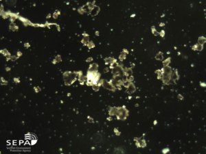
The ash particles range in size from 15 × 20 µm to 70 × 85 µm. (1 µm is a millionth of a meter, or a thousands of a millimeter).


Ash dust particles (at ×400) collected from Aberdeen on the morning of 16 April. These particles are approximately 60 × 70 µm.


Ash dust particles at ×100. Source and Copyright Scottish Environment Protection Agency.

Geoengineer This!

Credit: Golli / Kjartan Þorbjörnsson via MBL-Is. Image may be subject to copyright.

What Happend to Disaster Tourism?

The rascals coiled their tails and ran for the coast. Nearby roads covered in a thick blanket of volcanic ash. Credit: Ómar Óskarsson via MBL-Is. Image may be subject to copyright.

Click link for Eyjafjallajökull Eruption – Satellite Images

The All Important Pronunciation: ‘Aye-ya fyah-tla jow-kutl

Related Links:

Videos

More Photos:

Technical information:

Webcams – Volcanoes in Iceland

Latest Images (RUV): http://www.ruv.is/flokkar/hamfarir

Related Headline News

Related Sites in Iceland (English)

Fire-Earth Links:

.

Serial No 1,585. Starting April 2010, each entry on this blog has a unique serial number. If any of the numbers are missing, it may mean that the corresponding entry has been blocked by Google/the authorities in your country. Please drop us a line if you detect any anomaly/missing number(s).

Posted in Eyjafjallajökull, Fimmvörduháls, Iceland volcano, Katla, Laki | Tagged: , , , , , , | 4 Comments »

China quake death toll rises to 1,144

Posted by feww on April 17, 2010

The death toll from the powerful earthquake in China’s Qinghai province rises to 1,144, with another 417 missing

About 11,744 have been injured,  Xinhua news agency reported rescue team officials as saying.


Children, showing early signs of frostbite on their faces, prepare to sleep in the open
in sub-zero temperatures at a square in Tibetan Autonomous Prefecture of Yushu, northwest China’s Qinghai Province, April 15, 2010. (Xinhua/Li Ziheng). Image may be subject to copyright.

An estimated 15,000 homes have been destroyed in Yushu county, leaving  100,000 people homeless, many of them having to sleep in the open in sub-zero temperatures, in the remote high altitude region, which lies at about 4,000m (13,000ft).

Some 500 interpreters have been sent to the quake-stricken region because 97 percent of the Yushu population are ethnic Tibetans.

The 7.0 to 7.1Mw quake, which struck on April 14, 2010,  destroyed homes, schools and other public infrastructure. It knocked out power lines and triggered landslides, blocking roads and access routes.

Related Links:

.

Serial No 1,584. Starting April 2010, each entry on this blog has a unique serial number. If any of the numbers are missing, it may mean that the corresponding entry has been blocked by Google/the authorities in your country. Please drop us a line if you detect any anomaly/missing number(s).

Posted in China quake, earthquake update, Earthquakes, Qinghai quake, Yushu earthquake | Tagged: , , , | Leave a Comment »

Earth’s water cycle has accelerated: Researcher

Posted by feww on April 17, 2010

Ocean salinities show an intensified water cycle

Public Release: CSIRO Australia

Evidence that the world’s water cycle has already intensified is contained in new research to be published in the American Journal of Climate.

The stronger water cycle means arid regions have become drier and high rainfall regions wetter as atmospheric temperature increases.

The study, co-authored by CSIRO scientists Paul Durack and Dr Susan Wijffels, shows the surface ocean beneath rainfall-dominated regions has freshened, whereas ocean regions dominated by evaporation are saltier. The paper also confirms that surface warming of the world’s oceans over the past 50 years has penetrated into the oceans’ interior changing deep-ocean salinity patterns.

“This is further confirmation from the global ocean that the Earth’s water cycle has accelerated,” says Mr Durack – a PhD student at the joint CSIRO/University of Tasmania, Quantitative Marine Science program.

“These broad-scale patterns of change are qualitatively consistent with simulations reported by the Intergovernmental Panel on Climate Change (IPCC).

“While such changes in salinity would be expected at the ocean surface (where about 80 per cent of surface water exchange occurs), sub-surface measurements indicate much broader, warming-driven changes are extending into the deep ocean,” Mr Durack said.

The study finds a clear link between salinity changes at the surface driven by ocean warming and changes in the ocean subsurface which follow the trajectories along which surface water travels into the ocean interior.

The ocean’s average surface temperature has risen around 0.4ºC since 1950. As the near surface atmosphere warms it can evaporate more water from the surface ocean and move it to new regions to release it as rain and snow. Salinity patterns reflect the contrasts between ocean regions where the oceans lose water to the atmosphere and the others where it is re-deposited on the surface as salt-free rainwater.

“Observations of rainfall and evaporation over the oceans in the 20th century are very scarce. These new estimates of ocean salinity changes provide a rigorous benchmark to better validate global climate models and start to narrow the wide uncertainties associated with water cycle changes and oceanic processes both in the past and the future – we can use ocean salinity changes as a rain-gauge,” Mr Durack said.

Based on historical records and data provided by the Argo Program’s world-wide network of ocean profilers – robotic submersible buoys which record and report ocean salinity levels and temperatures to depths of two kilometres – the research was conducted by CSIRO’s Wealth from Oceans Flagship and partially funded by the Australian Climate Change Science Program. Australia’s Integrated Marine Observing System is a significant contributor to the global Argo Program.

Contact: Craig Macaulay
Craig.Macaulay@csiro.au
CSIRO Australia

Related Links:

.

Serial No 1,583. Starting April 2010, each entry on this blog has a unique serial number. If any of the numbers are missing, it may mean that the corresponding entry has been blocked by Google/the authorities in your country. Please drop us a line if you detect any anomaly/missing number(s).

Posted in Climate Change, ocean surface, Ocean Warming, water cycle | Tagged: , , , , | Leave a Comment »

Eyjafjallajökull Eruption – Satellite Images

Posted by feww on April 17, 2010

Ash cloud from Eyjafjallajökull eruption has grounded about 30,000 flights, so far!


Ash from Iceland’s erupting Eyjafjallajökull Volcano had drifted over northern Europe by April 16, 2010. The brown ash is mixed with clouds in this photo-like image taken by MODIS on NASA’s Terra satellite at 12:45 p.m. local time (GMT/UTC+2) on April 16,2010. The visible ash sweeps in an arc across the Netherlands, Germany, Poland, and Russia. Additional ash is most probably masked by clouds. Source: NASA. Click image to enlarge.


The Moderate Resolution Imaging Spectroradiometer (MODIS) on NASA’s Terra satellite captured this natural-color image on April 15, 2010. A volcanic plume blows from Eyjafjallajökull Volcano in southern Iceland toward the east-southeast. The plume’s tan hue indicates a high ash content. Volcanic ash consists of tiny jagged particles of rock which can cause engine failure, if sucked into an airplane’s turbines. Source: NASA. Click image to enlarge.

DLR, TerraSAR-X, via Associated Press

A computer enhanced image of  Eyjafjallajokull glacier in Iceland acquired by the TerraSAR-X satellite on April 16, 2010 (late PM).
Image may be subject to copyright. Click image to enlarge.

For the latest Eyjafjallajökull update and links see

.

Serial No 1,582. Starting April 2010, each entry on this blog has a unique serial number. If any of the numbers are missing, it may mean that the corresponding entry has been blocked by Google/the authorities in your country. Please drop us a line if you detect any anomaly/missing number(s).

Posted in Eyjafjallajökull, Fimmvörduháls, Iceland volcano, Katla, Laki | Tagged: , , , , , , | 2 Comments »