Fire Earth

Earth is fighting to stay alive. Mass dieoffs, triggered by anthropogenic assault and fallout of planetary defense systems offsetting the impact, could begin anytime!

Posts Tagged ‘Cape Verde Islands’

1st Storm of Alantic Hurricane Season: Big Bang or Damp Whimper?

Posted by feww on June 14, 2010

Large, Well Organized, Low Pressure System 975 Miles WSW of Cape Verde Islands Moving NW at 15 MPH

A large, well-organized, low pressure system located about 1,000 miles WSW of the Cape Verde islands is moving northwestward at up to 15 MPH, NWS TPC/National Hurricane Center said.

Updated at approximately 2 AM, 8 AM, 2 PM, and 8 PM EDT from June 1 to November 30. Special outlooks may be issued as conditions warrant.   Click image to enlarge and update.

The system could become a tropical cyclone over the next 48 hours, with a probability of 60 percent, the center added.

The system “is producing widespread cloudiness along with some showers and thunderstorms.”

Satellite images show a second system tailing the first.

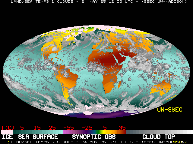
Sea Surface Temperature (SST) Atlantic and East Pacific Oceans

Latest Global Montage (UW-SSEC)

Posted in Alantic Hurricane Season 2010, Atlantic Hurricane Season Outlook, Atlantic ocean, tropical cyclone, tropical cyclone alex | Tagged: , , , , | Leave a Comment »

Humongous Dust Storm Sweeps Africa

Posted by feww on March 20, 2010

10,000-km dust storm plagues Africa


Click here to download large image (5 MB, JPEG)

A massive  dust storm stretching from the Red Sea to the Atlantic Ocean swept across the southern Sahara Desert, Africa on March 19, 2010. Composite image, spanning more than 10,000 kilometers (6,000 miles), was taken by NASA/Aqua/Terra/ MODIS and consists of 7 satellite overpasses. Gray triangular areas represent satellites blind spots. The composite also captured another dust storm blowing across Arabia (see upper right corner). Source: NASA

Related Links:

Posted in africa dust storm, Arabian Peninsula, Sahara Desert, Sandstorm | Tagged: , , , , , | 5 Comments »

Vanishing Fred & Atlantic Hurricane Season 2009

Posted by feww on September 11, 2009

Wondering what happened to the Atlantic Hurricane Season?

As [tiny] Fred begins to fizzles out of its hurricane status in the Atlantic ocean about 1,190 km (740 miles) west of Cape Verde Islands, mot everyone must be thinking whatever happened to the 2009 Atlantic hurricane season.

jsl-l - Fred
Hurricane Fred. GOES Floater Imagery – Still Image – See inset for date and time. Click image to enlarge and update.

Summary of Hurricane Fred Status: Fred is weakening further as it slows down more.
AT 11:00 PM AST Thu Sep 10, Fred was located at 17.4°N 35.1°W, at max sustained wind speeds of about  140 km/h (85 mph) moving north at a forward speed of 5 km/h
(3 mph) with a min pressure of 735.1 mmHg (80 mb), NHC/NOAA said, expecting it to downgrade to a tropical storm within the next 24 hrs.

For one thing, it’s not over yet, at least not until the “fat lady” strikes. The peak months are August to October.

For another, the strengthening El Niño episode seems to be disrupting storm formation in the Main Hurricane Development Region, the Atlantic basin, AND forcing the storms away from land.

In fact, NOAA’s updated 2009 Atlantic Hurricane Season Outlook predicts a 90% chance of a near-normal or below normal hurricane season.

NOAA recounts two competing climate factors.

1. The persisting “multi-decadal signal” that has been “associated with elevated levels of Atlantic hurricane activity since 1995, along with warmer than average sea surface temperatures (SSTs) in the tropical North Atlantic Ocean and Caribbean Sea.”

2. The El Niño episode, which is  “producing increased wind shear in the Main Hurricane Development Region.”

Based on these mix of climatic factors, NOAA updated prediction for the 2009 hurricane season is

  • 50% chance of a near-normal season
  • 40% chance of a below normal season
  • Only an unlikely 10% chance of an above-normal season

The outlook indicates a 70% probability for each of the following seasonal ranges: 7-11 named storms, 3-6 hurricanes, 1-2 major hurricanes, and an ACE range of 60%-110% of the median. Most of this activity is expected during the upcoming peak months (August-October) of the hurricane season.

For an in-depth analysis by NOAA see: 2009 Atlantic Hurricane Season Outlook Update

Related Links:
Posted in Atlantic Hurricane Season Outlook, Caribbean Sea, El Niño, ENSO, multi-decadal signal, sea surface temperatures, tropical North Atlantic Ocean | Tagged: , , , , | 4 Comments »