Fire Earth

Earth is fighting to stay alive. Mass dieoffs, triggered by anthropogenic assault and fallout of planetary defense systems offsetting the impact, could begin anytime!

Posts Tagged ‘Atlantic ocean’

1st Storm of Alantic Hurricane Season: Big Bang or Damp Whimper?

Posted by feww on June 14, 2010

Large, Well Organized, Low Pressure System 975 Miles WSW of Cape Verde Islands Moving NW at 15 MPH

A large, well-organized, low pressure system located about 1,000 miles WSW of the Cape Verde islands is moving northwestward at up to 15 MPH, NWS TPC/National Hurricane Center said.

Updated at approximately 2 AM, 8 AM, 2 PM, and 8 PM EDT from June 1 to November 30. Special outlooks may be issued as conditions warrant.   Click image to enlarge and update.

The system could become a tropical cyclone over the next 48 hours, with a probability of 60 percent, the center added.

The system “is producing widespread cloudiness along with some showers and thunderstorms.”

Satellite images show a second system tailing the first.

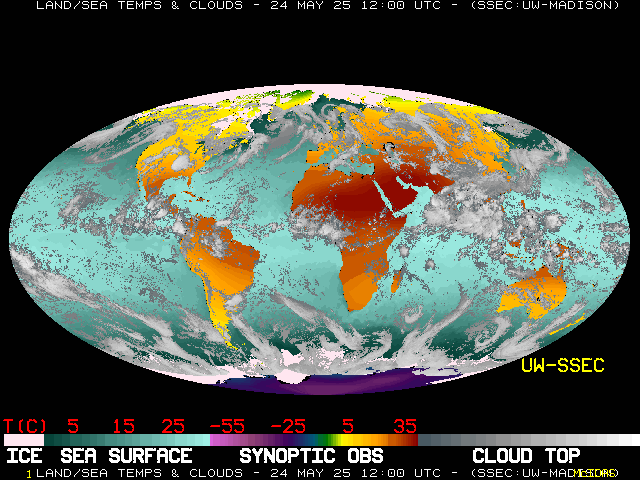
Sea Surface Temperature (SST) Atlantic and East Pacific Oceans

Latest Global Montage (UW-SSEC)

Posted in Alantic Hurricane Season 2010, Atlantic Hurricane Season Outlook, Atlantic ocean, tropical cyclone, tropical cyclone alex | Tagged: , , , , | Leave a Comment »

Floods Kill 32 on Portuguese Island of Madeira

Posted by feww on February 21, 2010

Storm, Floods, Mudslides Target another Popular Tourist Destination

Heavy Storm, Extreme Rain, Torrential Floods and Massive Mudslides Bring Disaster to Portugal’s Atlantic Island of Madeira

At least 32 people were killed and up to a 100 others injured on the island of Madeira after heavy storms brought a violent downpour to the Atlantic island, flooding the popular tourist destination the local government reported Saturday.

“The areas of Funchal and Ribeira Brava suffered from major floods and mudslides, and that’s where we have most of the 32 dead. Some people are also unaccounted for,” said Pedro Barbosa, deputy chief of the regional civil protection service in Madeira.

“Now the weather conditions have improved and we are starting to evaluate the damage,” he said, Reuters reported.

The rains caused large-scale flooding and massive mudslides throughout the island, blocking roads and forcing airports on the island to shut down.

The 120km-per-hour winds and floods uprooted trees, washed away bridges and roads, damaged or destroyed many homes and smashed dozens of cars on the island.

Funchal, the island’s capital (about 1,000km south of Portuguese capital, Lisbon), was probably the worst affected areas by the floods and mudslides in an unusually rainy February.


Cars are washed down a hillside by floodwaters near Funchal, the Madeira Island’s capital, Saturday, February 20, 2010. Photo: AP. image may be subject to copyright.

Saturday’s disaster was reportedly the deadliest on Madeira since October 1993, when storms and floods killed eight people.


NO GAS SOLD AT THIS STATION UNTIL FURTHER NOTICE! [Original caption: A man looks on with a camera while floodwaters flow through a gas station and the streets of downtown Funchal, Madeira February 20, 2010.  Credit: REUTERS/Duarte Sa. Image may be subject to copyright.

Related Links:

Possibly related links:

Posted in extreme rain, flood, Madeira, mudslide, storm, Tourist Destination | Tagged: , , , , , | 5 Comments »

How Taklamakan Desert Enriches Oceans

Posted by feww on July 21, 2009

A huge dust storm in China’s Taklamakan desert in 2007 generated dust clouds  that circled the globe more than once in just 13 days: Study

“Asian dust is usually deposited near the Yellow Sea, around the Japan area, while Sahara dust ends up around the Atlantic Ocean and coast of Africa,” said Itsushi Uno of Kyushu University’s Research Institute for Applied Mechanics.


Taklamakan by NASA World Wind . One of the largest sandy deserts in the world, Taklamakan covers an area of 270,000 km² (three quarters) of the Tarim Basin.

Astronaut Photography of Earth – Display Record – STS059-84-51


Taklamakan Dust Storm.

“But this study shows that China dust can be deposited into the (Pacific Ocean),” Reuters reported him as saying. “Dust clouds contain 5 percent iron, that is important for the ocean.”

“The most important achievement is that we tracked this through one full circuit round the globe, nobody has done this before. After half a circuit, usually the dust concentration gets very low and you can’t track it,” Uno told Reuters.

“This means that dust concentration, dust lifetime is very long, more than two weeks.”

The dust cloud envelope, measuring about 3 km high and 2,000 km long, retained its structure even after it had circled the globe once.

“The reason why the cloud structure was very well maintained was because the dust was uplifted … where the atmosphere is very stable,” Uno said.

Previously …


Dust storm over China’s Taklamakan Desert, on April 14, 2002, from the MODIS Instrument on NASA’s Terra Satellite.

Researches using an atmospheric computer model previously showed that dust from the TaklaMakan desert in China traveled more than 20,000 kilometers over two weeks landing on the French Alps. “Chinese dust plumes have been known to reach North America and even Greenland, but have never been reported before in Europe.” (Source).


A DUSTY PATH FROM CHINA TO FRANCE — The spiked line shows the dust’s 315 hour (13+ days) trip from the TaklaMakan desert in China, circling the world (counterclockwise) and landing in the French Alps on March 6, 1990. The black star is where scientists gathered samples.

Related Links:
Posted in China dust cloud, cirrus clouds, coast of Africa, dust lifetime, iron-rich dust | Tagged: , , , , | Leave a Comment »

Air France Flight 447

Posted by feww on June 9, 2009

Breaking News: Cockpit Fire Forces Airbus A330 to Land

Images of the Day: Air France Flt 447

af 447 airbus tail section
Brazilian search team recovers debris from the Air France Airbus flight 447  that crashed over the Atlantic last week (Recovery dated June 8,2009). Photo: Brazilian Air Force Handout.


A piece of debris from Air France flight AF447 is seen on the deck of a Brazilian Navy vessel after being picked up out of the Atlantic Ocean, some 745 miles (1,200 km) northeast of Recife, in this handout photo distributed by the Navy on June 7, 2009. REUTERS/Brazilian Air Force/Handout.

Related Links:

Posted in air france airbus, air NZ airbus, Airline industry, Brazil, France | Tagged: , , , , | 2 Comments »

Gustav spares New Orleans levees

Posted by feww on September 2, 2008

Insured losses could still reach $10 billion

Hurricane Gustav slammed ashore near Cocodrie, Louisiana, about 115 km southwest of New Orleans on Monday.

Gustav weakened to a Category 2 hurricane with 177 kph winds [just 1kph shy of a category 3 hurricane on the Saffir-Simpson Hurricane Scale] before landfall and as it moved inland weakened to a Category 1 hurricane with 130 kph winds.


A street at a railroad crossing near the Inner Harbor Navigational Canal is flooded as Hurricane Gustav hits New Orleans, September 1, 2008. REUTERS/Lee Celano. Image may be subject to copyright.

Weaker than Katerina on landfall, Gustav spared the levees which were breached by Katrina in 2005 flooding the city killing about 1800 and stranding hundreds of thousands of people.

About six inches of water flooded streets around New Orleans Industrial Canal, and strong winds knocked down trees, but no substantial damage has yet been reported.


In case you wondered what Gustav looked liked! –  Clouds looming over New Orleans looked like a scene right out of “Independence Day.” (Stephen Morton/Getty Images). Image may be subject to copyright.

It is  estimated that Gustav’s insured losses could reach $10 billion. Katrina’s insured losses were reported at about $40 billion and total damage was more than $81.2 billion [2005 dollars.]

Gustav seemed to have caused more damage in the Caribbeans while near full strength. It killed a total of about 100 people in the Dominican Republic, Haiti, Jamaica and Cuba. According to Cuban authorities more than 90,000 houses were damaged or destroyed by Gustav. Reuters reported.

As Gustav swept inland over the United States, tropical storm Hanna strengthened to a hurricane near the Bahamas, and Tropical Storm Ike formed in the Atlantic Ocean.

Click here for Gustav’s latest image.

Posted in Climate Change, energy, environment, food, Global Warming, health, politics, Tourism, Travel | Tagged: , , , , , , | Leave a Comment »

TSs Hannah and Gustav

Posted by feww on August 29, 2008

Latest: Tropical Storm Front Update 9-3

Tropical Storm [‘Big’] Hannah Chases Gustav

Tropical Storm Hanna regional imagery, 2008.08.29 at 08:45UTC.
Centerpoint Latitude: 21:17:12N Longitude: 62:25:56W.


Data Elements:
Tropical Storm Hanna is located north-northeast of the northern Leeward Islands. This system is moving toward the northwest near 22km/hr. Maximum sustained winds are near 85km/hr.
Observation Device: GOES-12  4-km infrared imagery.
Visualization Date: August 29, 2008 08:05:16 UTC
Credit NOAA – Environmental Visualization Service

noaa logo Gustav and Hannah – GOES Puerto Rico SECTOR IR Image – Updated Image

:
Puerto Rico Sector (IR Ch 4, Mercator Projection) – Credit: the National Oceanic and Atmospheric Administration (NOAA)

Tropical storm Hanna advisory number 5

  • Hanna is poorly organized at this time.
  • At 09:00 UTC the center of tropical storm Hanna was located near latitude 21.7 North, …longitude 62.3 West or about 400 km north-northeast of the northern Leeward Islands.
  • Hanna is moving toward the northwest near 22 km/hr.   A motion between west-northwest and northwest away from the Leeward Islands is expected during the next  24 hrs.
  • Maximum sustained winds are near 85 km/hr with higher gusts.  Little change in strength is forecast today but Hanna could become a hurricane in a couple of days.
  • Tropical storm force winds extend outward up to 85 km from the center.
  • Estimated minimum central pressure is 1000 mb (29.53 inches).

Rain bands associated with Hanna could produce rainfall accumulations of 1 to 2 inches across portions of the Leeward Island. – Forecaster Avila

Tropical Storm Hanna regional imagery, 2008.08.28 at 16:15UTC.
Centerpoint Latitude: 19:10:50N Longitude: 58:37:25W.


Data Elements:
Hanna has become the eighth tropical storm of the 2008 season.
Observation Device: GOES-12 1 km visible imagery.
Credit NOAA – Environmental Visualization Service

Posted in Climate Change, energy, environment, food, Global Warming, health, Tourism, Travel | Tagged: , , , , | Leave a Comment »