
News Release: University of California – Berkeley
Strongest evidence to date shows link between exploration well and Lusi mud volcano
Improper removal of drill bit from unstable well led to uncontrolled influx of gas and water
 New data provides the strongest evidence to date that the world’s biggest mud volcano, which killed 13 people in 2006 and displaced thirty thousand people in East Java, Indonesia, was not caused by an earthquake, according to an international scientific team that includes researchers from Durham University and the University of California, Berkeley.
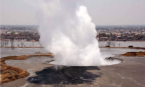
The main vent of the Lusi mud volcano taken within a few months of eruption. (Durham University photo).
Drilling firm Lapindo Brantas has denied that a nearby gas exploration well was the trigger for the volcano, instead blaming an earthquake that occurred 280 kilometers (174 miles) away. They backed up their claims in an article accepted this week for publication in the journal Marine and Petroleum Geology, by lead author Nurrochmat Sawolo, senior drilling adviser for Lapindo Brantas, and colleagues.
In response, a group of scientists from the United Kingdom, United States, Australia and Indonesia led by Richard Davies, director of the Durham Energy Institute, have written a discussion paper in which they refute the main arguments made by Nurrochmat Sawolo and document new data that provides the strongest evidence to date of a link between the well and the volcano. That paper has been accepted for publication in the same journal.
 Satellite image of the Lusi mud volcano. The white plume in the centre of the picture is steam from the central vent of the volcano. (Ikonos satellite image, copyright CRISP NUS 2007/200)
“The disaster was caused by pulling the drill string and drill bit out of the hole while the hole was unstable,” Davies said. “This triggered a very large ‘kick’ in the well, where there is a large influx of water and gas from surrounding rock formations that could not be controlled.
“We found that one of the on-site daily drilling reports states that Lapindo Brantas pumped heavy drilling mud into the well to try to stop the mud volcano. This was partially successful and the eruption of the mud volcano slowed down. The fact that the eruption slowed provides the first conclusive evidence that the bore hole was connected to the volcano at the time of eruption.”
The Lusi volcano, which first erupted on May 29, 2006, in the Porong sub-district of Sidoarjo, close to Indonesia’s second city of Surabaya, East Java, now covers seven square kilometers – nearly three square miles and is 20 meters (65 feet) thick. The mud flow has razed four villages and 25 factories. Thirteen people have died as a result of a rupture in a natural gas pipeline underneath one of the holding dams. The Lusi crater has been oozing enough mud to fill 50 Olympic size swimming pools every day. All efforts to stem the mud flow have failed, including the construction of dams, levees, drainage channels, and even plugging the crater with concrete balls. Lusi may continue to erupt for decades, scientists believe.
Arguments over the causes of the Lusi volcano have stalled the establishment of liability for the disaster and delayed compensation to thousands of people affected by the mud. The Yogyakarta earthquake that occurred at the time of the volcano was cited by some as a possible cause of the eruption, but the research team rejected this explanation.
Lusi Mud Volcano [Click images to enlarge]
 Original Caption: On May 29, 2006, hot mud began to pour from the ground near a gas exploration well, covering fields and villages in the Sidoarjo region of East Java, Indonesia. Despite efforts to staunch the flow, the mud kept coming, forming the world’s largest and fastest growing mud volcano. By the time the Advanced Spaceborne Thermal Emission and Reflection Radiometer (ASTER) on NASA’s Terra satellite captured this false-color image on October 20, 2009, the erupting mud truly resembled a volcano.
Walls contain the mudflow to a rectangular region in the center of the image. The landscape beyond the walls is still covered in plants, which are red in this false-color image. Water, usually dark blue in this type of image, is silvery white from reflected sunlight. The bright squares on the right side of the image are shrimp farms, and the ribbon of white along the bottom of the image is the Kali Porong, a river. Reflecting sunlight also colors the outer edges of the mudflow silver and highlights the texture of the growing mound over the vent at the center of the volcano. The mound was not visible in an ASTER image acquired in late 2008.
Called Lusi, the volcano formed suddenly in May 2006 probably because of drilling at the nearby gas well, say scientists from Indonesia, the United Kingdom, the United States, and Australia. The day before the eruption, pressurized gas and fluid flowed into the well, raising the pressure. The fluid and gas escaped into the surrounding earth, forcing mud to the surface along nearby cracks. As of June 2008, as much as 100,000 cubic meters of mud flowed from the volcano every day. This image shows that the eruption continued into 2009. Lusi’s formation forced more than 30,000 people from their homes, destroyed more than 10,000 homes, schools, and other structures, and may have a wider impact on coastal and marine ecosystems. NASA image created by Jesse Allen, using data from NASA/GSFC/METI/ERSDAC/JAROS, and the U.S./Japan ASTER Science Team. Caption by Michon Scott, based on interpretation by Geoffrey S. Plumlee, U.S. Geological Survey Crustal Imaging and Characterization Team.

Lusi Mud Volcano – Sidoarjo Mud Flow, Indonesia. Image acquired November 11, 2008. Credit: NASA (see above).

Image of Sidoarjo, E.J. Indonesia (prior to Lusi mud eruptions) – Image acquired August 28, 2004 . Credit: NASA (see above).
The Durham University-led group of scientists believe that their analysis resolves the cause beyond all reasonable doubt. According to their discussion paper, ‘The pumping of heavy mud caused a reduction in the rate of flow to the surface. The reason for pumping the mud was to stop the flow by increasing the pressure exerted by the mud column in the well and slowing the rate of flux of fluid from surrounding formations.’
“An earthquake trigger can be ruled out because the earthquake was too small given its distance, and the stresses produced by the earthquake were minute smaller than those created by tides and weather,” said co-author Michael Manga, professor of earth and planetary science at the University of California, Berkeley.
The group of scientists has identified five critical drilling errors as the causes of the Lusi mud volcano eruption:
- having a significant open hole section with no protective casing
- overestimating the pressure the well could tolerate
- after complete loss of returns, the decision to pull the drill string out of an extremely unstable hole
- pulling the bit out of the hole while losses were occurring
- not identifying the kick more rapidly
“This is the clearest evidence uncovered so far that the Lusi mud volcano was triggered by drilling,” Davies said. “We have detailed data collected over two years that show the events that led to the creation of the Lusi volcano.”
“The observation that pumping mud into the hole caused a reduction in eruption rate indicates a direct link between the wellbore and the eruption,” he added. “The decision was made to pull the drill bit out of the hole without verifying that a stable mud column was in place and it was done while severe circulating mud losses were in progress. This procedure caused the kick.”
Contact: Robert Sanders
rsanders@berkeley.edu
510-643-6998
University of California – Berkeley
Previous Press Release: Javan mud volcano triggered by drilling, not quake
Related Links:

