ENSO Cycle: Recent Evolution, Current Status and Predictions
The following UPDATE is prepared by Climate Prediction Center / NCEP – 7 December 2009
The latest weekly SST departures are:
- Niño 4 ~ 1.4ºC
- Niño 3.4 ~ 1.7ºC
- Niño 3 ~ 1.4ºC
- Niño 1+2 ~ 0.4ºC

El Niño Map. [SOURCE: NOAA/ Climate Prediction Center / NCEP]
SST Departures (°C) in the Tropical Pacific During the Last 4 Weeks
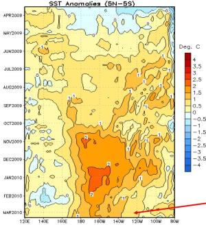
During the last 4-weeks, SSTs were at least 1.0°C above average across much of the equatorial Pacific and more than 2.0°C above average between 180°and 130°W.
Global SST Departures (°C)
During the last four weeks, equatorial SSTs were above-average across the Pacific and Indian Oceans. Also, above-average SSTs covered large areas of the Northern Hemisphere subtropics.
Weekly SST Departures (°C) for the Last Four Weeks
- During the last four weeks, positive SST anomalies persisted across the central and eastern equatorial Pacific Ocean.
- During the last 30 days, equatorial SST anomalies only changed in small regions across the equatorial Pacific.
Sub-Surface Temperature Departures (°C) in the Equatorial Pacific
- During October –November 2009, positive temperature anomalies at thermocline depth increased and expanded eastward across the eastern equatorial Pacific, in response to the downwelling phase of an oceanic Kelvin wave.
- The most recent period indicates the eastward expansion of positive anomalies has slowed in the eastern Pacific Ocean.
Atmospheric Circulation over the North Pacific & North America During the Last 60 Days
See: El Niño Update [30 Nov 2009]
Weekly Heat Content Evolution in the Equatorial Pacific

(A) The negative anomalies weakened during January-March 2009, with positive anomalies becoming established in late March.
(B) In April 2009, the combined effects of an oceanic Kelvin wave and weaker-than-average easterly trade winds contributed to an increase in the upper-ocean heat content anomalies across the Pacific Ocean.
Since April 2009, heat content anomalies have remained above-average, but there has been considerable month-to-month variability due to Kelvin wave activity.
(C) During November, the downwellingphase of a Kelvin wave contributed to an increase in heat content.
Oceanic Kelvin waves have alternating warm and cold phases. The warmp hase is indicated by dashed lines. Down-welling and warming occur in the leading portion of a Kelvin wave, and up-welling and cooling occur in the trailing portion.
Low-level (850-hPa) Zonal (east-west) Wind Anomalies (m s -1)
From April-October 2009, the MJO was weak to nonexistent. Since May 2009, westerly wind anomalies have covered large portions of the equatorial Pacific, except near the Date Line.During November 2009, the MJO became active, which contributed to anomalous easterlies shifting eastward from the Indian Ocean to the central and eastern Pacific. Recently, westerly anomalies have returned across much of the equatorial Pacific Ocean.
Summary
- El Niño is present across the equatorial Pacific Ocean.
- Sea surface temperatures (SST) are at least 1.0ºC-2.0ºC above-average across much of the central and east-central equatorial Pacific.
- Based on current observations and dynamical model forecasts, El Niño is expected to last through at least the Northern Hemisphere winter2009-10.
Information and images on this page are sourced from Climate Prediction Center/NCEP/NOAA. Edited by FEWW
Related Links:
El Niño Updates:


 |
|
