Earth is fighting to stay alive. Mass dieoffs, triggered by anthropogenic assault and fallout of planetary defense systems offsetting the impact, could begin anytime!
Emergency Bulletins are now available via FIRE-EARTH PULSARS.
-------------------------------
We do NOT use Twitter or Facebook accounts. Our user names including "FEWW" have been hijacked by trolls.
-------------------------------
WARNING: WordPress Digitally Tracking Visitors!
Injury Claims Against Google: Fire-Earth posts important news & unique analysis that could help save you from harm, but Google [Alphabet Inc] filters the blog to protect their vast business interest. If you incur any injury or loss due to the denial of information, you may sue the Internet Mafia for damages.
STOP CENSORING THE REAL NEWS
WordPress is HACKING this blog!
WordPress continues to hack FIRE-EARTH & affiliated blogs at the behest of its corporate clients.
Blog Moderators condemn in the strongest terms the blatant removal and manipulation of content.
Starting January 29, 2013, Google & WordPress have restricted access to FIRE-EARTH reducing blog traffic by up to 95 percent, enabling their affiliated sites and commercial partners to hijack (and twist) the news, analysis and core ideas presented here.
Blocking information, hacking websites and twisting the facts concerning harm inflicted to Earth by humans are major crimes against nature, punishable by drought, famine, disease...
Caution
Technical information and scientific data from the US Government agencies (NASA, EPA…) are subject to variation due to political expediency.
This caution also extends to the UN organizations (e.g., FAO, WHO…).
As of August 2011, FIRE-EARTH will no longer reprint photos from NASA, due to the agency's wanton crimes against nature.
May 2024
M
T
W
T
F
S
S
1
2
3
4
5
6
7
8
9
10
11
12
13
14
15
16
17
18
19
20
21
22
23
24
25
26
27
28
29
30
31
COPYRIGHT NOTICE
ORIGINAL CONTENT POSTED ON THIS BLOG ARE COPYRIGHTS OF THE BLOG AUTHORS.
Content MAY BE REPRODUCED FOR EDUCATIONAL PURPOSES BY PRIOR PERMISSION ONLY.
REPRINTING FOR COMMERCIAL PURPOSES OR POSTING ON BLOGS THAT CARRY COMMERCIAL ADS IS STRICTLY PROHIBITED.
YOU may NOT copy, re-blog or otherwise reproduce any part of this blog on Facebook or Twitter.
Guatemala’s Fuego volcano erupts – most violent eruption in 4 decades.
The eruption, second this year, killed at least 25 people,and left about 300 injured. “Volcano of Fire” ejected a thick column of smoke and ash more than 8-kilometer into the air.
Most of the casualties were located in three towns: El Rodeo, Alotenango and San Miguel los Lotes.
#VolcánDeFuego Se realiza monitoreo en aldea El Rodeo y comunidad La Reina con personal de la Coordinadora Local para la Reducción de Desastres -COLRED- de La Reina, no se registra caida de ceniza. Fuente: Wotzbely Suárez, Técnico de Campo de la Secretaría Ejecutiva de la CONRED. pic.twitter.com/9Vmdb6rrVT
21 Wildfires have burned more than 191,000 acres in Calif.
ALL residents of Calistoga and Geyserville were ordered to abandon their homes.
Emergency Declarations have been proclaimed by the state governor for Napa, Sonoma, Yuba, Butte, Lake, Mendocino, Nevada, Orange and Solano counties.
At least 29people are confirmed to have died in N. California wildfires this week, with 285 others reported as missing.
The ferocious fires have destroyed an estimated 3,500 homes and businesses, and charred more than 191,500 acres (~ 77,500 hectares).
The wildfires have also destroyed or substantially damaged at least 13 Napa Valley wineries, and razed entire neighborhoods, with an estimated total of 2,834 homes, in the city of Santa Rosa.
Tens of thousands have evacuated their homes, including 25,000 people in Sonoma County alone, while 8,000+ personnel are trying to contain the fires.
Red Flag Warnings have been issued for much of Northern California due to gusty winds and low humidity starting today. While these winds may hamper the efforts of firefighters, they will also increase the risk for new wildfires. [Cal Fire]
“We’re not going to be out of the woods for a great many days to come,” said Cal Fire director.
“We’ve had big fires in the past,” said Gov. Brown. “This is one of the biggest.”
15 Law enforcement officers complained of “headaches and dizziness” after explosions
“A flooded chemical plant near Houston exploded twice early Thursday, sending a plume of smoke into the air and triggering a fire that the firm plans to let ‘burn itself out,'” a report said.
The owner-operator, the France-based Arkema Group, one of the world’s largest chemical companies, had warned on Wednesday that the plant would catch fire and explode, and that there was nothing to stop it.
All residents within the 1½-mile-radius of the plant were evacuated on Tuesday
The plant is located in Crosby, Texas (about 20 miles NE of Houston) was submerged under 6 feet of water from Hurricane HARVEY and had been without electricity since Sunday, the report said.
“We have an unprecedented 6 feet of water throughout the plant. We’ve lost primary power and two sources of emergency backup power. And as a result, critical refrigeration needed for our materials on site is lost,” the chief executive of the company’s North America operations told reporters.
Fema said on Thursday that “the plume [was] incredibly dangerous,” and that evacuations were based on “plume modeling,” used to predict the geographic extent of a hazard area from an explosion.
Summary of Information at 6:00 AM CDT (11:00 UTC) – [NHC/NOAA]
Max Sustained Winds: 110 mph [177km/hr; currently a Category 2B Hurricane on FEWW Hurricane Scale] and Strengthening
Location: 26.3°N, 95.7°W
About 145 mi (235km) SE OF CORPUS CHRISTI, TEXAS
About 150 mi (245) SSE OF PORT O’CONNOR, TEXAS
Movement: NW (315 degrees) at 10 MPH (17 km/h)
MCP: 952 MB (28.11 inches)
Authorities have warned residents in coastal areas and beyond to evacuate their homes amid potentially “life-threatening winds and floods.”
The strengthening hurricane, forecast to become a Cat 4 hurricane with winds of up to 125 mph (200 km/h), could dump as much as 36 inches (100 cm) of rain on parts of Texas, and cause storm surge as high as 12 feet (3.65 meters).
“Life-threatening and devastating flooding expected near the coast due to heavy rainfall and storm surge,” the NHC said.
State of Disaster
Texas governor has declared a state of disaster for 30 counties and has ordered the Texas Department of Public Safety’s State Operations Center to upgrade its readiness status before HARVEY hits.
Mass Evacuations
Multiple mandatory and voluntary evacuations are currently in effect.
Potential for Disaster
“If a hurricane hits the thousands of storage tanks — ones that hold the world’s largest concentrations of oil, gases and chemicals — that line the Houston Ship Channel just right, more than 25 feet of water could shoot up the channel. And if even one tank ruptured because of it, hundreds of thousands of people could be impacted,” said a report.
U.S. National Fire Preparedness Remains at Maximum Level 5
Lolo Peak Fire, Montana
Current as of 8/18/2017, 1:43:36 PM [Inciweb]
Incident Type: Wildfire
Cause: Lightning/natural
Date of Origin: Saturday July 15th, 2017 approx. 02:34 PM
Location: 10 miles southwest of Lolo, Montana
Incident Description: Lolo Peak Fire Is A Long Duration Wildfire With The Potential To Reach The Corridors Of Highway 12 And Highway 93.
Current Situation
Total Personnel: 603
Size: 18,896 Acres
Projected Incident Activity: Very active fire behavior. Backing, flanking, and running fire with single tree and group torching, short uphill crown runs. Potential for multiple active areas at a time. [Up to 750 homes evacuated, according to reports.]
The Milli Fire, Oregon
A large wildfire threatened 434 structures, prompting authorities to advise about 1,200 residents to stand by for possible evacuation.
The Milli Fire, located west of the Deschutes County community, is approximately 4,565 acres and 0% contained, Inciweb reported.
Wildfire: Current as of 8/18/2017, 3:02:51 PM
Cause: Unknown
Date of Origin: Tuesday August 15th, 2017 approx. 05:00 PM
Location: 9 miles west of Sisters OR (in Three Sisters Wilderness)
Current Situation
Total Personnel: 250
Size: 4,565 Acres
Narrative: Extreme fire behavior, and has grown significantly in the last 24 hours. Active fire front on Trout Creek Butte with short-range spotting. Crews had to initiate burnout operations along 15 road as holding feature.
Tennessee wildfires kill 14, damage or destroy 2,500 buildings, force mass evacuations
The WH has declared a major disaster exists in the US state of Tennessee following the losses and damage caused by the deadly wildfires during the period of November 28 to December 9, 2016,
The blazes killed at least 14 people and damaged or destroyed more than 2,500 homes, businesses and other buildings, forcing about 15,000 people to evacuate the town of Gatlinburg in Sevier County, eastern Tennessee.
Ferocious wildfire in Squirrel Valley, Kern County destroys 100 homes, structures threatens 1,500 more
One of the most devastating wildfires I’ve ever seen —Kern County Fire Capt.
The explosive Erskine Fire has consumed about 5,400 acres since Thursday afternoon in Lake Isabella, Kern County, about 65km northeast of Bakersfield, destroying at least 80 homes, two dozen structures, and threatening 1,500 more.
The fire is “extremely dangerous, extremely volatile,” said Kern County Fire Capt. Tyler Townsend.
“I’ve never been in a wildland fire where I’ve seen so many homes burn. It’s one of the most devastating I’ve ever seen,” said Townsend.
Mass evacuations have been ordered in the areas threatened by the blaze including the rural communities of South Fork, Weldon, Onyx, Lakeland Estates, Yankee Canyon and Mountain Mesa, according to official reports.
LATEST: The Saddle Fire is now forcing hundreds of evacuations in the Pine Valley recreation area north of St. George, Utah. Several trail and road closures are now in place, US Forest Service-Dixie reported.
The lightning-sparked Saddle Fire, which started on June 13, has now grown to more than 650 acres, threatening at least 185 structures.
Meanwhile, NWS reported RECORD HEAT across Utah.
[Official] U.S. Wildfire Stats
Some 132 new fires, including 21 large fires (7 new) burning 135,372 acres.
States currently reporting large fires:
Alaska (2), Arizona (3), California (5), Colorado (4), Montana (1), New Mexico (1), Utah (2)
Washington (1), Wyoming (2)
Authorities have evacuated multiple properties in Palermo as raging wildfires, believed to have started intentionally, and fanned by the powerful ‘Sirocco’ winds, continue to spread across several parts of Sicily.
The fires have forced the closure of several motorways and highways across the affected areas. “The A20 motorway between Palermo and Messina was shut down to the wildfires that are also threatening several buildings and hotels in the area. The 113 state highway between Lascari and Cefalù was also closed. Some 50 nursery-school children were overcome by fumes from a fire on Monte Caputo at Monreale near Palermo and taken to hospital, while the school was evacuated,” ANSA reported.
Sicily’s President Rosario Crocetta told reporters that he believed the fires were started by organized crime.
“How do you explain a blazing fire in Cefalù [on Wednesday night,] when the temperature was [only] 24 degrees?
“Of course, the heat and wind then play their part. I do not have proof, but I suspect criminals were responsible because they always affect the most valuable areas around Palermo,”he said.
Large swathes of the US domed by oppressive and dangerous heat
Dangerous heat expected to continue across the midsection of the U.S. in addition to the Desert Southwest.
Oppressive and dangerous heat persists across parts of Plains…Mississippi Valley and the Desert Southwest. Numerous excessive heat warnings in effect across the Desert Southwest and parts of the Plains. Widespread heat advisories are in effect from the Gulf Coast to central Plains. Severe thunderstorms will be possible across parts of the northern Plains on Saturday. —NWS
“The persistent ridge anchored over the central U.S. will keep the oppressive and dangerous heat across the southern Plains and Mississippi Valley. The Desert Southwest is also facing extreme heat, with the scale tipping well over the century mark. Places around Phoenix can even see temperatures over 110 degrees this weekend. Numerous excessive heat warnings in effect across the Desert Southwest, Kansas and Oklahoma. Widespread heat advisories are in effect from the Gulf Coast to central Plains.” —NWS/WPC
Wildfire burning in Santa Barbara County explodes to 4,000 acres
The so-called Sherpa fire, burning in Santa Barbara County, is threatening homes and forcing closure of major highways.
“The Santa Barbara County Sheriff’s Office said mandatory evacuations for El Capitan, Refugio, Venadito and Las Flores canyons north of Santa Barbara remained in effect, while residents of neighboring communities such as Las Llagas, Gato, Las Varas, Dos Pueblos and Eagle canyons received evacuation warnings,” LA Times reported.
Tropical Storm ROANU displaces more than 1.3 million in Bangladesh and Sri Lanka
More than 1 million people have been evacuated in Bangladesh following the devastation caused by Tropical Storm ROANU.
The storm made landfall in Bangladesh on 21 May, killing dozens of people and destroying or damaging about 100,000 houses across 15 districts. The Chittagong, Noakhali, Lakshmipur and Chandpur districts being among the worst hit, said the Bangladeshi Department of Disaster Management.
Sri Lanka
Floods and landslides triggered by Tropical Storm ROANU have affected 400,000 people across Sri Lanka, since May 15.
The storm related disasters have killed about 90, and left 116 others missing. The floods have displaced about 300,000 people. “The majority of the displaced are in Colombo and Gampaha districts. Water, sanitation and hygiene, health, shelter and food have been identified as priorities.” OCHA reported.
Maldives
Continuous heavy rainfall and storm surges on 15 islands have damaged/destroyed homes and properties.
Micronesia
All four island states of Micronesia remain under States of Emergency due to severe drought which continues to affect 100,000 people. Yap and the Chuuk Northwest region are the worst affected. The Government reports that food security for the outlying islands is a serious concern with saltwater intrusion destroying taro patches, the main staple crop. Yap State is currently providing food assistance to residents of the outlying islands. [UN OCHA]
Marshall Islands
Despite recent rainfall, an estimated 21,000 people remain severely affected by El Niño-induced drought across the Marshall Islands. Food baskets are being prepared for distribution to people in the outer islands. An outbreak of conjunctivitis or pinkeye (inflammation of the eye) was also reported in Majuro.
Health officials have linked the outbreak to the limited water available for handwashing. [UN OCHA]
“Fire conditions remain extreme, with 18 new starts across Alberta yesterday. A total of 49 wildfires are burning, with seven considered out of control, 12 being held, 23 under control, and seven turned over to the responsible parties,” said Alberta Government.
Damage to Fort McMurray “Extensive,” the City “Unsafe” for Residents: Alberta Premier
The explosive blaze, which erupted on Sunday, had grown to about 90,000 hectares by Thursday.
State of Emergency continues across in the disaster area across Fort McMurray and surrounding communities.
Mandatory Mass Evacuations of about 88,000 residents are nearly completed.
The residents will not be able to return home anytime soon, officials have warned.
The fire has destroyed thousands of structures in the city.
“The damage to the community of Fort McMurray is extensive and the city is not safe for residents,” said Alberta Premier Rachel Notley Thursday evening.
The flames are spreading to the communities of Anzac and Gregoire Lake Estates and posing “extreme threat” to the areas south and southeast of Fort McMurray, as of Thursday evening (local time).
UPDATE:
Fort McMurray Wildfire creating its own weather, lightning
“The wildfire threatening to engulf the city has become so powerful it has created its own firestorm,” reported CBC.
The powerful firestorm has created its own weather system, funneling smoke and particulates high into the stratosphere, and generating powerful lightning strikes, sad the report.
“They tend to promote their own kind of conditions,” said a meteorologist for Environment Canada.
“That’s why you’ll see the winds near fires … that are significantly stronger that the surrounding atmosphere.”
FIRE-EARTH Disaster Models estimate the direct damage costs from the fire at $5 billion, based on the data available, as of posting. [Total damage costs could easily exceed $10 billion.]
Mandatory Mass Evacuations: 88,000 residents flee Fort McMurray, surrounding communities
The explosive wildfire that is raging around Fort McMurray, the Canadian oil city in the provice of Alberta, has consumed about 8,000 hectares so far, destroying 1,600 structures in the city, said Alberta Premier Rachel Notley.
“There’s been fairly significant destruction of residences,” she told reporters in Edmonton on Wednesday.
“We’re looking at roughly 1,600 structures at this point, so we’ve begun conversations with our federal partners about work that will need to be done with respect to restoration and recovery once the fire is brought under control.”
“We successfully evacuated 88,000 people,” fire Chief Darby Allen said at a news conference. “No one is hurt and no one has passed away.”
Fort McMurray effectively cut off from the rest of Alberta
“Currently that fire, at Airport Road and Highway 63 … has jumped both sides of the road, and traffic is no longer moving north or south,” a city official said on Wednesday evening.
Morning dawns on the widespread devastation in Beacon Hill, where 80 per cent of homes were lost. (Sylvain Bascaron/CBC)
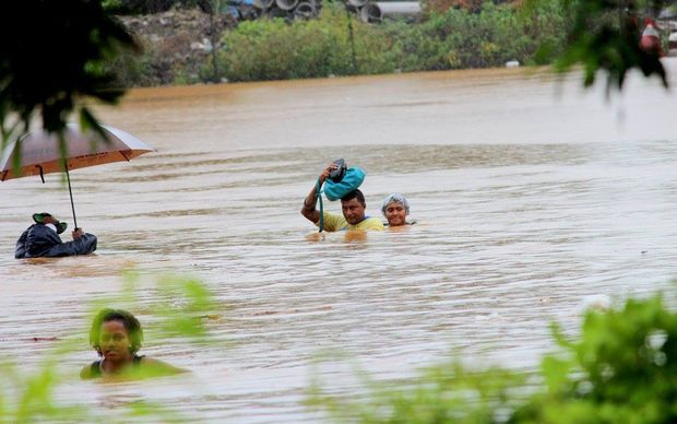
Flooding in Pakistan’s northwest and in Kashmir has claimed more lives raising the death toll to at least 71 Tuesday, officials said.
“The number known to have died in rains so far in the northwest has now risen to 61 with over 350 houses damaged all over Khyber Pakhtunkhwa,” the local officials said.
Severe flooding kills 28 in Ethiopia: Official media
At least 28 people have been killed in severe flooding in two remote regions of Ethiopia, reported the official news agency.
At least 23 people were killed and 84 others injured after a river that crosses Jigjiga, the regional capital of the Somali region, burst its banks on Sunday.
Extreme rain events flooded the drought-stricken region of Afar, causing severe flooding, and killing five people, AP reported.
Two tropical depressions continue to impact Fiji
The town of Nadi has been submerged under meters of floodwater since Sunday after heavy rain, and people throughout Fiji brace for even more flooding.
More than 3,500 people have fled their homes seeking shelter in about 80 evacuation centers in the north and west of the main island Viti Levu, as a double whammy of tropical depressions continue to impact the country, said a report.
At least one person was killed and another missing in weather related incidents.
Residents of Korociri cross the flooded Nadi Back Road. Photo: Fiji Government
Category 5, Severe Tropical Cyclone WINSTON struck the island nation on 20 and 21 February cutting a path of destruction across the country, wiping out entire communities/villages, and prompting the government to declare a state of disaster.
Drought-stricken Palau could dry up completely this month
Drought-stricken Palau could dry up completely this month, officials warned Monday as the Pacific island appealed for urgent international aid, including shipments of drinking water.
The tiny nation of 18,000 people declared a state of emergency in march, “the latest Pacific island nation to do so as one of the worst ever El Nino-induced droughts in the region worsens.”
“We’re still in the state of emergency, there’s a sense of urgency to address the crisis,” a government spokesman told AFP as the National Emergency Committee (NEC) met to discuss strategy.
Washington Wildfires (EM-3372) – Incident period: August 13, 2015 – Emergency Declaration declared on August 21, 2015
The White House has declared an emergency exists in the State of Washington in the areas affected by wildfires beginning on August 13, 2015, and continuing.
Areas that are worst affected by the deadly blazes are the counties of Asotin, Chelan, Douglas, Ferry, Klickitat, Okanogan, Pend Oreille, Skamania, Spokane, Stevens, and Yakima and the Confederated Tribes of the Colville Reservation, the Kalispel Tribe of Indians, the Spokane Tribe of Indians, and the Confederated Tribes and Bands of the Yakama Nation.
Washington Gov. had requested a Federal Disaster Declaration for the State of Washington as dozens of lightning-sparked wildfires raged uncontrollably killing and injuring fire crews.
“Currently 11 counties and 4 tribes are affected or threatened by fires with 39 confirmed residences and 60 other structures destroyed [and] over 235,000 acres burned,” Gov. Inslee had said in his official request. “Over 3,600 homes remain threatened, and these numbers are increasing each day as the largest fires remain uncontained.”
“Washington State had a major disaster declaration on August 11, 2014 for Washington Wildfires (DR-4188) in Okanogan County from the Carlton Complex Fire. The impacts of this current event are likely to exacerbate the ongoing housing and economic recovery efforts from the declared disaster last year.”
New Evacuation Orders Issued in Washington
The State emergency officials issued additional evacuation orders for more communities and towns threatened by deadly wildfires in Washington, including the entire population of Tonasket, and several parts of Okanogan, as dozens of large wildfires continued to scorch the drought-parched region.
Up to a 100 major fires are currently burning about 1.75 million acres in western, northwestern and southern U.S., according to FIRE-EARTH estimates.
The states reporting major wildfires are Arizona, California, Idaho, Montana, Nevada, North Carolina, Oregon, Texas and Washington, according to NIFC.
At least 41,525 fires have burned 7,293,666 acres so far this season, said NIFC.
Fire Management Assistance Declarations
The Federal Officials have also declared the following Fire Management Assistance Declarations:
Oregon Grizzly Bear Fire Complex (FM-5107)
Incident period: August 13, 2015 – Fire Management Assistance Declaration declared on August 21, 2015
Washington Twisp River Fire (FM-5106)
Incident period: August 19, 2015 – Fire Management Assistance Declaration declared on August 19, 2015
15,000 Residents ordered to evacuate their homes in Saskatchewan
At least 112 wildfires are burning through the northern region of Saskatchewan, forcing about 17,000 residents in 51 communities to evacuate.
“Saskatchewan’s Buffalo Narrows and La Ronge regions are the hottest wildfire spots at the moment, but there are also 10 uncontained blazes tearing through the province’s Prince Albert region, further to the south” said a report.
Fire Stats Communities under full or partial evacuation orders: 51 Total number of residents evacuated or under evacuation orders: 17,000
Number of active wildfires (July 6, 2015) : 112
Number of active wildfires greater than 100 hectares: 56 (July 5, 2015)
Wildfires to date: 574 (compared with total of 184 to date in 2014, and seasonal total of 193 blazes)
Western Canada Disaster Watch
Wildfires are also raging in the rest of Western Canada, with B.C. and Alberta experiencing similar hot and dry conditions, said CTV News.
Port Hardy, B.C. declared a state of emergency on Saturday as a wildfire forced the evacuation of 100 homes. The fire is one of 64 that are active across the province.
There were also more than 120 wildfires burning across Alberta, with hundreds of northern residents put on evacuation alert.
About 1,000 military personnel have been sent to help contain wildfires in Saskatchewan and assist evacuees relocation.
Red Flag Warnings in effect across much of Washington State, as wildfire forces 1,000 people to flee
A fast-moving wildfire fueled by high temperatures and strong winds has destroyed dozens of building, including homes, in Wenatchee in central Washington, about 200km east of Seattle.
The so-called Sleepy Hollow fire ignited in grass just outside Wenatchee on Sunday afternoon forcing residents of about 450 homes to flee.
The blaze had consumed more than 3,000 acres, as of posting.
State of Emergency
Gov. Inslee declared a statewide drought emergency for Washington in May due to the snowpack being at historic lows, dwindling rivers and irrigation districts being forced to cut off water to farmers.
Statement from Gov. Inslee about the Sleepy Hollow fire in Wenatchee
“Yet again, our state is experiencing a catastrophic wildfire that has displaced families and shut down businesses …”
Walker declares a state disaster in response to Sockeye Fire
Alaska Gov. Walker has declared a state disaster in response to widespread damages caused by the Sockeye Fire wildfire in Willow and the surrounding region.
Early Tuesday, the Alaska Division of Forestry estimated the Sockeye Fire had grown to 7,585 acres.
Major fires burning in Alaska include:
Chisana River 2 Fire Wildfire Wrangell-St. Elias National Park & Preserve (Active) 8,550 acres
Sockeye Fire Wildfire Mat – Su Area Forestry (Active) 7,512 acres
Bogus Creek Fire Wildfire Southwest Area Forestry (Active) 25,260 acres
Whitefish Lake 1 Fire Wildfire Southwest Area Forestry (Active) 14,827 acres
The 700-acre wildfire called Card Street Fire, has destroyed dozens of homes on the Kenai Peninsula, threatening hundreds of additional structures and forcing the evacuation of hundreds of homes.
Meantime, Alaska Governor Walker issued a disaster declaration for the affected areas.
Image credit: Stefan Hinman/Mat-Su Borough spokesperson. More images…
Sockeye Fire near Willow
Another fast-moving fire near Willow, the Sockeye Fire, has destroyed at least 25 primary homes and as many as 20 secondary homes, according to Alaska Forestry Division spokesman Sam Harrel.
Alaska Division of Forestry’s latest update on the Sockeye Fire near Willow:
The fire is still estimated at 6,500 acres [the fire is now up to 8,500 acres] and fire managers flew the fire this morning to get a gauge on fire activity and how far the fire has spread since last night. Heavy smoke over the southern perimeter of the fire south of Willow Creek has made size up difficult and fire managers are working to produce an updated map of the fire. As of late last night, the head of the fire was burning just south of Willow Creek and did not show much movement overnight. The Matanuska-Susitna Borough has set up a call center for people seeking information about the fire. The number at the call center is (907) 861-8326. For a recorded update, call (907) 761-3700. Fire activity died down last night due to cooler temperatures and higher relative humidities but activity is expected to increase today as a result of a Red Flag Warning for strong winds, hot temperatures and low relative humidity. Winds are expected to be out of the north again today, which will likely push the fire south. Fire managers plan to utilize roads and natural barriers to help control the fire. They are focusing on holding the fire at the railroad tracks on the east side of the Parks Highway and the Susitna River serves as a natural barrier on the west side. Evacuation advisories remain in effect from Miles 63 to 78 and extend two miles to the east of the highway and to the Susitna River on the west. Anyone still in that evacuation zone should seriously consider leaving the area for the safety of themselves and firefighters. As of late last night, there were approximately 25 primary structures and 10-20 secondary structures destroyed by the fire north of Kashwitna Lake on the north end of the fire. The Matanuska-Susitna Borough has a team that is assessing structure damage today to get a clearer indication of how many homes and structures were lost. Eight smokejumpers were deployed to remote cabin sights for structure protection and more resources have been ordered from the Lower 48 and Canada and are enroute to the fire. That includes five Type 1 hotshot crews, five Type 2 crews, two air tankers, and multiple helicopters, including three Blackhawk helicopters from the Alaska Air National Guard.
Deadly floods triggered by Extreme rain events have inundated thousands of villages and communities across southern Thailand, affecting tens of thousands of people and leaving more than a dozen dead or missing, said reports.
The head of military junta in Thailand has declared states of disaster for eight southern provinces of Pattani, Songkhla, Surat Thani, Nakhon Si Thammarat, Phatthalung, Narathiwat, Trang, and Yala, which have been submerged since mid-December, with at least 200,000 households affected.
Deadly floods have forced about 250,000 people out of their homes in Thailand and Malaysia so far this month.
Will someone declare state of emergency in Malaysia?
Deadly floods have killed at least 4 people and forced more than 90,000 others to flee their homes across six states in northern Malaysia since last week.
The worst affected areas are the states of Kelantan, Terengganu, Pahang, Perak, Perlis and Kedah.
The Malaysian Prime Minister Najib Razak is “facing heavy criticism over the timing of his holiday abroad amid the worst floods in the country,” said the Malaysian Insider.
He is in Hawaii playing golf with the U.S. Disaster President, according to reports.
“[A]s floods worsen in the country, there has been almost no demonstration of urgency and leadership from the National Security Council chaired by the Prime Minister,” said Malaysia Chronicle, describing the floods as Malaysia’s “worst natural disaster in recent history.”
Extreme Rain Events (EREs) Plague Entire Western Italy
Flooding and mudslides have destroyed orchards, vineyards in Tuscany, Liguria, and Veneto regions of Italy, said officials
Mass evacuations were ordered in coastal areas of Tuscany and Liguria, as extreme rain events triggered severe flooding and mudslided. Authorities issued a “red alert” for most of Liguria.
“Schools have been closed in Carrara, which is halfway between Florence and Genoa, while trains have also been stopped,” said a report.
In the Tuscan city of Carrara, halfway between Florence and Genoa, more than 200 meters of riverbank collapsed into Carrione River, with floodwaters trapping hundreds of families inside their homes.
The Po River in Lombardy rose by more than two meters in 24 hours on Wednesday.
The lagoon city of Venice was also flooded by high water.
Piemonte and parts of Liguria have also been put heightened alert amid EREs, said reports.


EW said