Earth is fighting to stay alive. Mass dieoffs, triggered by anthropogenic assault and fallout of planetary defense systems offsetting the impact, could begin anytime!
Emergency Bulletins are now available via FIRE-EARTH PULSARS.
-------------------------------
We do NOT use Twitter or Facebook accounts. Our user names including "FEWW" have been hijacked by trolls.
-------------------------------
WARNING: WordPress Digitally Tracking Visitors!
Injury Claims Against Google: Fire-Earth posts important news & unique analysis that could help save you from harm, but Google [Alphabet Inc] filters the blog to protect their vast business interest. If you incur any injury or loss due to the denial of information, you may sue the Internet Mafia for damages.
STOP CENSORING THE REAL NEWS
WordPress is HACKING this blog!
WordPress continues to hack FIRE-EARTH & affiliated blogs at the behest of its corporate clients.
Blog Moderators condemn in the strongest terms the blatant removal and manipulation of content.
Starting January 29, 2013, Google & WordPress have restricted access to FIRE-EARTH reducing blog traffic by up to 95 percent, enabling their affiliated sites and commercial partners to hijack (and twist) the news, analysis and core ideas presented here.
Blocking information, hacking websites and twisting the facts concerning harm inflicted to Earth by humans are major crimes against nature, punishable by drought, famine, disease...
Caution
Technical information and scientific data from the US Government agencies (NASA, EPA…) are subject to variation due to political expediency.
This caution also extends to the UN organizations (e.g., FAO, WHO…).
As of August 2011, FIRE-EARTH will no longer reprint photos from NASA, due to the agency's wanton crimes against nature.
June 2024
M
T
W
T
F
S
S
1
2
3
4
5
6
7
8
9
10
11
12
13
14
15
16
17
18
19
20
21
22
23
24
25
26
27
28
29
30
COPYRIGHT NOTICE
ORIGINAL CONTENT POSTED ON THIS BLOG ARE COPYRIGHTS OF THE BLOG AUTHORS.
Content MAY BE REPRODUCED FOR EDUCATIONAL PURPOSES BY PRIOR PERMISSION ONLY.
REPRINTING FOR COMMERCIAL PURPOSES OR POSTING ON BLOGS THAT CARRY COMMERCIAL ADS IS STRICTLY PROHIBITED.
YOU may NOT copy, re-blog or otherwise reproduce any part of this blog on Facebook or Twitter.
Magnitude: 6.9Mww
Location: 19.326°S 176.053°E [ 221km SW of Nadi, Fiji]
Depth: 17.1 km
Time: 2017-01-03 21:52:31 (UTC)
Tsunami Threat: NO widespread tsunami threat.
Aftershocks: At least 10 significant aftershocks as of 00:09:42 (UTC)
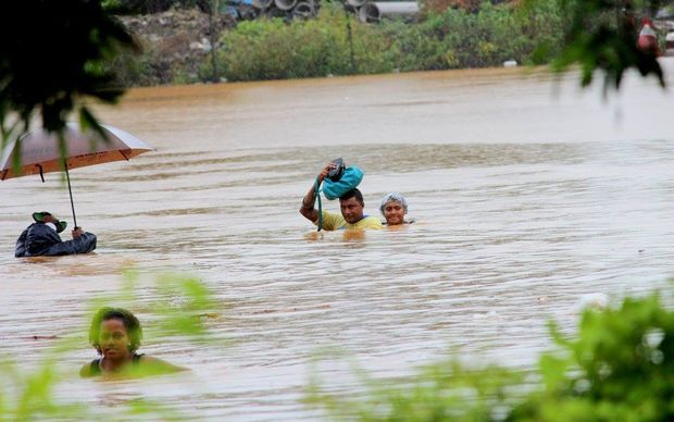
Flooding in Pakistan’s northwest and in Kashmir has claimed more lives raising the death toll to at least 71 Tuesday, officials said.
“The number known to have died in rains so far in the northwest has now risen to 61 with over 350 houses damaged all over Khyber Pakhtunkhwa,” the local officials said.
Severe flooding kills 28 in Ethiopia: Official media
At least 28 people have been killed in severe flooding in two remote regions of Ethiopia, reported the official news agency.
At least 23 people were killed and 84 others injured after a river that crosses Jigjiga, the regional capital of the Somali region, burst its banks on Sunday.
Extreme rain events flooded the drought-stricken region of Afar, causing severe flooding, and killing five people, AP reported.
Two tropical depressions continue to impact Fiji
The town of Nadi has been submerged under meters of floodwater since Sunday after heavy rain, and people throughout Fiji brace for even more flooding.
More than 3,500 people have fled their homes seeking shelter in about 80 evacuation centers in the north and west of the main island Viti Levu, as a double whammy of tropical depressions continue to impact the country, said a report.
At least one person was killed and another missing in weather related incidents.
Residents of Korociri cross the flooded Nadi Back Road. Photo: Fiji Government
Category 5, Severe Tropical Cyclone WINSTON struck the island nation on 20 and 21 February cutting a path of destruction across the country, wiping out entire communities/villages, and prompting the government to declare a state of disaster.
Drought-stricken Palau could dry up completely this month
Drought-stricken Palau could dry up completely this month, officials warned Monday as the Pacific island appealed for urgent international aid, including shipments of drinking water.
The tiny nation of 18,000 people declared a state of emergency in march, “the latest Pacific island nation to do so as one of the worst ever El Nino-induced droughts in the region worsens.”
“We’re still in the state of emergency, there’s a sense of urgency to address the crisis,” a government spokesman told AFP as the National Emergency Committee (NEC) met to discuss strategy.
TC WINSTON, strongest ever storm to hit Fiji, wreaks destruction across the island nation
Authorities in Fiji say the most powerful storm on record to hit the country has killed at least five people, razing entire villages and destroying hundreds of homes.
TC WINSTON slammed the tiny nation with 330-km winds, torrential rain and tsunami-like waves of up to 15m, according to FIRE-EARTH Models.
The destructive storm prompted the government to impose a nationwide curfew and declare a 30-day state of national disaster, said reports. [The declaration would empower police to arrest people without a warrant.]
Spokesman for Fiji’s National Disaster Management Office told reporters that about 80% of the population were without electricity.
Fiji PM described the storm as “an ordeal of the most grievous kind.”
DISASTER CALENDAR SYMBOLIC COUNTDOWN: 1,181 Days Left
[December 17, 2012] Mass die-offs resulting from human impact and the planetary response to the anthropogenic assault could occur by early 2016.
SYMBOLIC COUNTDOWN: 1,181 Days Left to the most Fateful Dayin Human History
Symbolic countdown to the ‘worst day’ in human history began on May 15, 2011 ...
.
Global Disasters/ Significant Events
EVAN attacks Fiji with destructive winds, torrential rains
Thousands of residents and tourists were evacuated as Cyclone EVAN, strengthened to a category 4 storm, battered Fiji with destructive winds and torrential rains, flattening homes and uprooting trees.
The authorities have warned the storm surge generated by the cyclone as it circles the main islands of Vanua Levu and Viti Levu coluld cause major flooding.
EVAN strengthened to a category 4 storm with wind gusts of up to 170 mph (275 kmh)
DISASTER CALENDAR SYMBOLIC COUNTDOWN: 1,182 Days Left
[December 16, 2012] Mass die-offs resulting from human impact and the planetary response to the anthropogenic assault could occur by early 2016.
SYMBOLIC COUNTDOWN: 1,182 Days Left to the most Fateful Dayin Human History
Symbolic countdown to the ‘worst day’ in human history began on May 15, 2011 ...
.
Global Disasters/ Significant Events
EVAN envelopes Fiji after causing large-scale destruction in Samoa
Killer Cyclone Evan intensified to a category 4 cyclone, having flattened thousands of homes and much of the infrastructure in Samoa.
The death toll in Samoa has risen to at least 4, with 9 people reported missing.
Powerful Cyclone EVAN. IR Satellite Image. Source: CIMSS
Official Name: Severe Tropical Cyclone EVAN. [Category Cyclone 4 has mean winds 86-107 knots with a central pressure 945-910 hPa]
Fijian prime minister addressing his nation of nearly a million people said:
“It [Cyclone EVAN] has winds up to 180 kilometers an hour which may intensify, and if the weather forecasters are correct it will affect Fiji in a very damaging way, bringing about destructive winds and flooding. I cannot stress how serious this is, every Fijian will be affected.”
About 100 evacuation centers have been set up in northern and western areas of Fiji, the Fijian national disaster management office said, advising people in the lower-lying areas to move to higher grounds.
Click image to enlarge.
Tropical Cyclone Mick hovered over the Fiji Islands on December 13, 2009, and intensified the following day, pounding the archipelago with strong winds and heavy rains. The Moderate Resolution Imaging Spectroradiometer (MODIS) on NASA’s Terra satellite captured this true-color image of Mick on December 13, 2009. The storm had maximum sustained winds of 55 knots (100 kilometers per hour) with gusts of to 70 knots (130 kilometers per hour).Image and caption credit: NASA Earth Observatory. [edited by FEWW]
Copra is the dried meaty sections, or kernel, of the coconut palm (Cocos nucifera). Traditionally, Copra has been the most important crop produced on Taveuni, Fiji.
Coconut palm (Cocos nucifera). Source: SOPAC. Image may be subject to copyright.
Ripe coconuts are split with a machete and laid out to dry in the sun. (Source).
Taveuni
The third-largest island in Fiji, Taveuni has a total land area of 440 square kilometers. The island is a gigantic shield volcano situated on the floor of the Pacific Ocean. Taveuni is known as the ‘Garden Island of Fiji’ because of its copious flora, thriving on rich volcanic soil.
The massive shield volcano rises to 1241 m and is dotted by about 150 volcanic cones along a NE-SW rift extending the length of the island; some of the SW-flank vents are visible on this Space Shuttle image (with north to the upper right). Taveuni has been frequently active during the Holocene, and eruptions impacted island settlements in prehistorical time. At least 58 eruptions have occurred on Taveuni since the first known human settlements of the Fiji Islands about 950-750 BC; all of these eruptions affected the southern two-thirds of the island. A period of voluminous eruptions between about 300 and 500 AD caused abandonment of the southern part the island of Taveuni until about 1100 AD. The latest known eruption produced a lava flow at the southern tip of the island sometime between about 1450-1650 AD. NASA Space Shuttle image STS111-719-74, 2002 (http://eol.jsc.nasa.gov/). Caption: GVP


