Fire Earth

Earth is fighting to stay alive. Mass dieoffs, triggered by anthropogenic assault and fallout of planetary defense systems offsetting the impact, could begin anytime!

Posts Tagged ‘Pilbara’

Heatwave Melts 50-Year Record in Perth, Australia

Posted by feww on February 9, 2016

CGFP

Perth records 40 plus degree temperatures three consecutive days

Western Australia’s capital city, Perth [pop:~ 2.1 million,] has recorded 40 plus degree (C) temperatures for three consecutive days, breaking a 50-year record for February, said a report.

The latest record-breaking heatwave was reportedly the seventh ever occurring in the region.

If the temperature reaches 40ºC or higher on Wednesday, it will be the first time there has been four consecutive 40ºC days since 1933, said Bureau of Meteorology (BoM) spokesman.

“Perth’s longest run of 40 degree days or more consecutively is four, and that was recorded back in 1933, if we get five we’ve broken that record and we’ve moved into uncharted territory basically.”

At sunrise today (Feb. 9), the temperature was 20ºC, reaching 32 within 2 hours, and 40ºC by 11:00am. It peaked at a sweltering 41.2ºC in the metro area, said the report.

“Pearce airbase was the hottest place in wider Perth at 44.3C and Mardie in the Pilbara was the state’s hotspot, reaching 45.6C.”

On Monday, the temperature reached 47ºCin Shark Bay Airport, situated in the Gascoyne region, northwest of Western Australia.

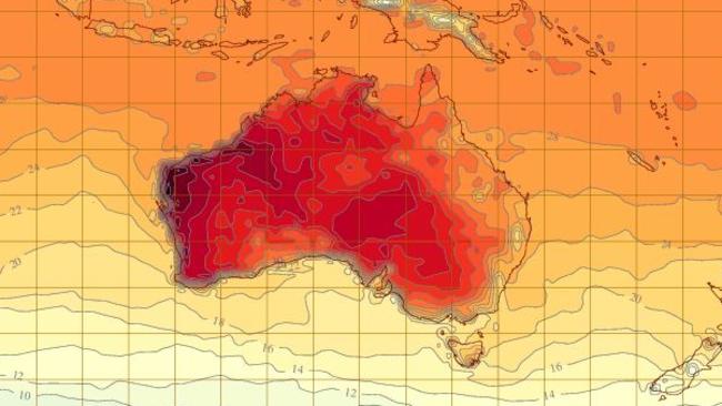
Image source: The Bureau of Meteorology BoM/ via news.com.au


Hottest place on Earth?

Temperatures touched 49°C in Sua Pan (Sowa Pan), a seasonal lake located in the Makgadikgadi region of Botswana, southern Africa, making it the hottest place on Earth, the UK Meteorological Office reported.

Meanwhile, Australia’s Bureau of Meteorology has confirmed that 2015 was Australia’s fifth-warmest year on record, with the release of its final Annual Climate Report 2015.

Heatwave Situation for Thursday, Friday, & Saturday (3 days starting 11/02/2016)

Severe to extreme heatwave conditions continue over much of northern and central WA. Low intensity heatwave conditions for most of NSW and Tasmania. [BOM]

Posted in News Alert | Tagged: , , , , , , , | Leave a Comment »

Tropical Cyclone STAN: Red Alert Issued in WA

Posted by feww on January 30, 2016

Destructive winds, storm surges, flooding threaten towns as cyclone approaches Western Australia

Tropical Cyclone STAN threatens northwest Pilbara region in Western Australia (WA) with potentially destructive wind gusts and heavy rain when the system makes landfall early on Sunday morning.

  • The storm, currently a category 2 system, is forecast to intensify to category three cyclone before landfall.
  • Red alert has been issued for coastal communities between Port Hedland and Wallal, including Pardoo, Eighty Mile and Wallal.
  •  Storm surges may pose additional threats of damaging waves and dangerous flooding due to the tide, said Australia’s Bureau of Meteorology (BOM).


Posted in News Alert | Tagged: , , , , , , | Leave a Comment »

Red Alert Issued as CHRISTINE Begins Landfall in WA

Posted by feww on December 30, 2013

Severe Tropical Cyclone CHRISTINE crossing Western Australia  coast with “very destructive winds”

“The VERY DESTRUCTIVE inner core of Severe Tropical Cyclone Christine has begun to impact the coast between Port Hedland and Whim Creek,” said the Australian Bureau of Meteorology (BOM).

Severe Tropical Cyclone CHRISTINE was located 90km west of Port Hedland and 100km east northeast of Karratha, moving SSW at 18km/h toward the Pilbara coast, at 8:00 pm WST, said BOM.

christine wv 30dec
Severe Tropical Cyclone  CHRISTINE. Infrared [FIRE-EARTH Enhancement] Satellite Image. Recorded at 10:32UTC on Sunday December 30, 2013. The original Image Sourced from: CIMSS/SSEC/WISC.

Cyclone Warning

A Cyclone Warning has been issued for coastal areas from Wallal to Onslow, including Port Hedland, Karratha and Onslow, and extending inland to Paraburdoo, Tom Price, Newman, Jigalong and Three Rivers, said BOM.

Red Alert

The authorities have issued a RED ALERT for residents in or near coastal areas between Pardoo and Mardie, including Port Hedland, South Hedland, Whim Creek, Roebourne, Point Samson, Wickham, Karratha and Dampier.

A Red Alert was also issued for Tom Price and Paraburdoo at 7pm local time (UTC + 8 hrs).

Severe Tropical Cyclone CHRISTINE Forecast Track Map

christine projected path map-bom
Issued at 7:08 pm WST Monday 30 December 2013. 

Related Links

Posted in Significant Event Imagery, significant events | Tagged: , , , , , , , , | Leave a Comment »

CHRISTINE Could Intensify to Cat 4 Severe Tropical Cyclone

Posted by feww on December 29, 2013

EXTREME CLIMATIC EVENT

Massive Storm CHRISTINE could intensify to a Category 4 Severe Tropical Cyclone

FIRE-EARTH Models show CHRISTINE could intensify to a Category 4 Severe Tropical Cyclone with sustained winds of 165 km/h or higher, and wind gusts in excess of 225 km/h over the next 24 hours, subject to continued favorable conditions [probability: 0.45]

As of 05:32 UTC on December 29, 2013 FIRE-EARTH models located  CHRISTINE (TC 05S) near 17.1ºS, 119.9ºE, about 425 km NNE of Port Hedland, Australia, inching SSW towards the Pilbara coast at a forward speed of about 3 km/h.

christine 29dec13 WV
Severe Tropical Cyclone  CHRISTINE. Infrared [FIRE-EARTH Enhancement] Satellite Image. Recorded at 04:32UTC on Sunday December 29, 2013. The original Image Sourced from: CIMSS/SSEC/WISC.

 ABOM Forecast

According to Australian Bureau of Meteorology (ABOM), CHRISTINE will develop to a Cat 3   Severe Tropical Cyclone at 5 am WST (UTC +8 hrs)  and weaken to Cat2 at 11 am on December 31.

christine projected path - ABOM
Severe Tropical Cyclone  CHRISTINE projected path.  Source: Australian Bureau of Meteorology (ABOM).

ABOM Cyclone Warning

“During Monday gales and heavy rainfall are expected to extend to Mardie and possibly as far west as Exmouth, and then to the inland Pilbara late Monday and on Tuesday. If Christine continues to develop as expected a severe tropical cyclone impact on the Pilbara coast is likely late on Monday or early on Tuesday, with VERY DESTRUCTIVE winds with gusts in excess of 170 kilometres per hour near the cyclone centre,” warned BOM.

“People on the coast between Pardoo and Mardie, including Port Hedland and Karratha, are warned of the potential for a VERY DANGEROUS STORM TIDE late Monday night or early Tuesday morning. Tides may rise significantly above the normal high tide mark with DAMAGING WAVES and VERY DANGEROUS COASTAL INUNDATION.”

Related Links

Posted in Climate Change, Significant Event Imagery, significant events | Tagged: , , , , , , , , , , , | 2 Comments »

CHRISTINE Even Fiercer than She Looks

Posted by feww on December 28, 2013

CHRISTINE Could Develop to Category 3 Severe Tropical Cyclone: FIRE-EARTH

FIRE-EARTH Models show Tropical Cyclone CHRISTINE could intensify to a Category 3 Severe Tropical Cyclone with sustained winds of 140 km/h or higher, and wind gusts in excess of 180 km/h over the next 24 -36 hours, subject to favorable conditions.

christine 28dec13 WV-s
Tropical Cyclone CHRISTINE. Water Vapor [FIRE-EARTH Enhancement] Satellite Image.  Recorded at 12:32UTC on Saturday December 28, 2013. The original Image Sourced from: CIMSS/SSEC/WISC.

At 13:00UTC on December 28, 2013 CHRISTINE was located about 505km north northeast of Port Hedland, Australia moving SSW at 11 km/h parallel to the coast. Maximum significant wave hight was about 4 meters.

“Ports in Australia’s Pilbara region, through which almost half of the world’s seaborne iron ore is shipped, were sending ships out to sea on Saturday ahead of a tropical cyclone that is forecast to reach the coast by Tuesday,” reported Reuters.

More than 40 vessels in the anchorages and harbor at Port Hedland will be leaving by early Sunday, according to the port authorities.

UPDATE
Embedded Thunderstorms

“A large area of embedded thunderstorms over the Kimberley, the western Top End and waters to the north, is associated with Tropical Cyclone Christine,” said  Australian BOM.

BOM has issued a  Cyclone Warning for coastal areas from Cape Leveque to Whim Creek, including Broome and Port Hedland and a Cyclone Watch for coastal areas from Whim Creek to Exmouth, including Karratha and Onslow, extending inland to Paraburdoo, Western Australia (WA).

Posted in Significant Event Imagery, significant events | Tagged: , , , , , , , , , , , | Leave a Comment »