*** Breaking News: May 19, 2008 Philippines Taal Volcano Could Erupt Anytime!
Where Could The Next Supervolcanic Eruption Occur?
1. Pico del Teide?
2. Mauna Loa?
3. Mount Vesuvius?
4. Mount Rainier?
5. Taal?
6. Thera?
Volcanoes
A volcano is an opening in a planet’s crust that allows ash, gases and molten rock to escape from below the surface.
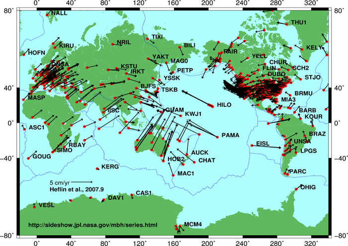
Volcanoes are generally found where tectonic plates converge or divrge. A mid-oceanic ridge, for example the Mid-Atlantic Ridge, has examples of volcanoes caused by “divergent tectonic plates” pulling apart; the Pacific Ring of Fire has examples of volcanoes caused by “convergent tectonic plates” coming together.

Author:MesserWoland via Wikimedia Commons.This file is licensed under the Creative Commons Attribution ShareAlike license versions 2.5, 2.0, and 1.0
Cross-section through a stratovolcano:
1. Large magma chamber ◊ 2. Bedrock ◊ 3. Conduit (pipe) ◊ 4. Base ◊ 5. Sill ◊ 6. Branch pipe ◊ 7. Layers of ash emitted by the volcano ◊ 8. Flank ◊ 9. Layers of lava emitted by the volcano ◊ 10. Throat ◊ 11. Parasitic cone ◊ 12. Lava flow ◊ 13. Vent ◊ 14. Crater ◊ 15. Ash cloud
Eruption Types
There are many different kinds of volcanic activity and eruptions: phreatic eruptions (steam-generated eruptions), explosive eruption of high-silica lava (e.g., rhyolite), effusive eruption of low-silica lava (e.g., basalt), pyroclastic flows, lahars (debris flow) and carbon dioxide emission. All of these activities can pose a hazard to humans. Earthquakes, hot springs, fumaroles, mud pots and geysers often accompany volcanic activity. (Source)

Image by USGS
The concentrations of different volcanic gases can vary considerably from one volcano to the next. Water vapor is typically the most abundant volcanic gas, followed by carbon dioxide and sulfur dioxide. Other principal volcanic gases include hydrogen sulfide, hydrogen chloride, and hydrogen fluoride. A large number of minor and trace gases are also found in volcanic emissions, for example hydrogen, carbon monoxide, halocarbons, organic compounds, and volatile metal chlorides.
Large, explosive volcanic eruptions inject water vapor (H2O), carbon dioxide (CO2), sulfur dioxide (SO2), hydrogen chloride (HCl), hydrogen fluoride (HF) and ash (pulverized rock and pumice) into the stratosphere to heights of 16–32 kilometres (10–20 mi) above the Earth’s surface. (Source)
Decade Volcanoes
The Decade Volcanoes are 16 volcanoes identified by the International Association of Volcanology and Chemistry of the Earth’s Interior (IAVCEI) as being worthy of particular study in light of their history of large, destructive eruptions and proximity to populated areas. The Decade Volcanoes project encourages studies and public-awareness activities at these volcanoes, with the aim of achieving a better understanding of the volcanoes and the dangers they present, and thus being able to reduce the severity of natural disasters. They are named Decade Volcanoes because the project was initiated as part of the United Nations sponsored International Decade for Natural Disaster Reduction. (Source)

The 16 current Decade Volcanoes
-
- Avachinsky–Koryaksky, Kamchatka, Russia
- Colima, Jalisco and Colima, Mexico
- Mount Etna, Sicily, Italy
- Galeras, Nariño, Colombia
- Mauna Loa, Hawaii, USA
- Mount Merapi, Central Java, Indonesia
- Mount Nyiragongo, Democratic Republic of Congo
- Mount Rainier, Washington, USA
|
- Sakurajima, Kagoshima Prefecture, Japan
- Santamaria/Santiaguito, Guatemala
- Santorini, Cyclades, Greece
- Taal Volcano, Luzon, Philippines
- Teide, Canary Islands, Spain
- Ulawun, New Britain, Papua New Guinea
- Mount Unzen, Nagasaki Prefecture, Japan
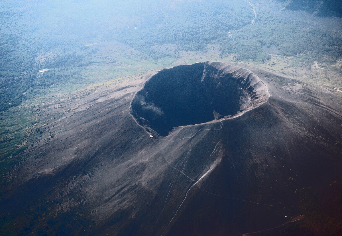
- Vesuvius, Naples, Italy
|

Mount St. Helens shortly after the eruption of May 18, 1980

1 km steam plume ejected from Mount St. Helens photo taken by USGS on May 19, 1982 [Mount St. Helens is located in Skamania County, Washington, in the Pacific Northwest region of the United States.]
Mount St. Helens is most famous for its catastrophic eruption on May 18, 1980, which was the deadliest and most economically destructive volcanic event in the history of the United States. Fifty-seven people were killed; 250 homes, 47 bridges, 24 km of railways, and 300 km of highway were destroyed. The eruption caused a massive debris avalanche, reducing the elevation of the mountain’s summit from 2,950 to 2,550m and replacing it with a 1.5 km-wide horseshoe-shaped crater. The debris avalanche was up to 2.9 km³ in volume (VEI = 5). (Source)

A large eruption at Mount Etna, photographed from the International Space Station

Mount Etna, Sicily . Last Eruption 2007. [Photo Credit: Josep Renalias, via Wikimedia commons]
This file is licensed under the Creative Commons Attribution ShareAlike 2.5

Koryaksky Volcano seen in the background. Last Eruption: 1957. GNU Free Documentation License, Version 1.2 or any later version. See file detail.

Cleveland Volcano in the Aleutian Islands of Alaska photographed from the International Space Station.

Mount Nyiragongo volcano, Virunga Mountains, the Democratic Republic of the Congo. [The main crater is 250 m deep, 2 km wide and sometimes contains a lava lake. Nyiragongo and nearby Nyamuragira are together responsible for 40% of Africa’s historical volcanic eruptions. (Source: USGS) Last Eruption: 2008 (continuing)

The three summits of Mount Rainier: Liberty Cap, Columbia Crest, and Point Success [Last Eruption 1854]
.jpg)
The snow-capped summit of Pico del Teide in December 2004 – Active but dormant volcano, Tenerife, Canary Islands. Last eruption 1909. Photo: M. D. Hill. This work is licensed under the Creative Commons Attribution 2.5 License.

An aerial photo of Vesuvius. last Eruption 1944 [Author: Pastorius? Via Wikimedia Commons. ] This file is licensed under Creative Commons Attribution 2.5 License

Taal Volcano seen from across Taal Lake on the island of Luzon in the Philippines. Last Eruption: 1977.
Supervolcanoes: Nature’s “Thermonuclear” Arsenal

Satellite image of Thera, November 21, 2000. The Minoan caldera is at the lower part of the image and formed in the Minoan eruption 1630 and 1600 BCE. The whole caldera is formed of three overlapping calderas.
The Minoan eruption of Thera, also referred to as the Thera eruption or Santorini eruption, was a major catastrophic volcanic eruption (VEI = 6, DRE = 60 km3) which is estimated to have occurred in the mid second millennium BCE. The eruption was one of the largest volcanic events on Earth in recorded history. The eruption destroyed most of the island of Thera, including the Minoan settlement at Akrotiri as well as communities and agricultural areas on nearby islands and on the coast of Crete. The eruption contributed to the collapse of the Minoan culture.
The eruption caused significant climatic changes in the eastern Mediterranean region, Aegean Sea and much of the Northern Hemisphere. There is also evidence that the eruption caused failure of crops in China, inspired certain Greek myths, contributed to turmoil in Egypt, and influenced many of the biblical Exodus stories. It has been theorized that the Minoan eruption and the destruction of the city at Akrotiri provided the basis for or otherwise inspired Plato’s story of Atlantis. (Source)

Volcanic craters on Santorini. This file is licensed under Creative Commons Attribution 2.5 License [ photo: Rolfsteinar, via Wikimedia Commons]

Lake Taupo is a lake situated in the North Island of New Zealand. It has a perimeter of approximately 193km, a deepest point of 186 m and a surface area of 616 square km.
The lake lies in a caldera created following a huge volcanic eruption (see supervolcano) approximately 26,500 years ago. According to geological records, the volcano has erupted 28 times in the last 27,000 years. It has predominantly erupted rhyolitic lava although Mount Tauhara formed from dacitic lava.
The largest eruption, known as the Oruanui eruption, ejected an estimated 1,170 km³ of material and caused several hundred square kilometres of surrounding land to collapse and form the caldera. The caldera later filled with water, eventually overflowing to cause a huge outwash flood.

NASA satellite photo of Lake Taupo
Several later eruptions occurred over the millennia before the most recent major eruption, which occurred in 180 CE. Known as the Hatepe eruption, it is believed to have ejected 120 km³ of material, of which 30 km³ was ejected in the space of a few minutes. This was one of the most violent eruptions in the last 5,000 years (alongside the Tianchi eruption of Baekdu at around 1000 and the 1815 eruption of Tambora), with a Volcanic Explosivity Index rating of 7. The eruption column was twice as high as the eruption column from Mount St. Helens in 1980, and the ash turned the sky red over Rome and China. The eruption devastated much of the North Island and further expanded the lake. Unlike today, the area was uninhabited by humans at the time of the eruption, since New Zealand was not settled by the Māori until several centuries later. Taupo’s last known eruption occurred around 210 CE, with lava dome extrusion forming the Horomatangi Reefs. (Source)
Related Links:


