Posts Tagged ‘Satellite Image’
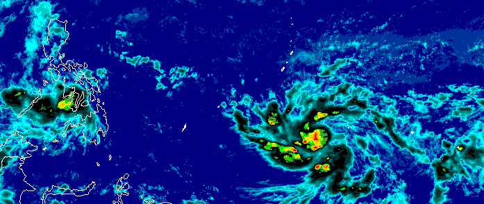
Posted by feww on September 27, 2015
UPDATED @ 13:30UTC
21W continues strengthening – almost a Super Typhoon
Typhoon 21W (DUJUAN) threatens Taiwan region with major disasters –
– FIRE-EARTH Models forecast with high probability large scale devastation caused by destructive winds, high waves, torrential rain, flash flooding, mudflows and landslides for the region.
At 13:30UTC – Sunday, September 27, 2015
- Position: Near 22.8N, 125.7E
- Max Wind Speed: ~ 245 km/hr
- Max Wind Gusts: ~ 295 km/hr
- Forward Speed and Direction: 14 km/hr – WNW
- Max Significant Wave Height: ~ 15 meters

Image Source: Taiwan Central Weather Bureau
Latest Images
Predicted Path
Related Links
Posted in News Alert | Tagged: Disaster Warning, DUJUAN, FIRE-EARTH Models, major disaster, Satellite Image, Taiwan, TY 21W, Typhoon DUJUAN | Leave a Comment »
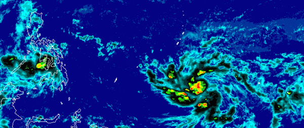
Posted by feww on September 27, 2015
DUJUAN (TY 21W) now packing sustained winds of more than 240 km/hr
At 06:30UTC – Sunday, September 27, 2015
- Position: Near 22.5N, 126.6E
- Max Wind Speed: ~240 km/hr
- Max Wind Gusts: 295 km/hr
- Forward Speed and Direction: 12 km/hr – 280 degrees
- Max Significant Wave Height: ~ 15 meters

Image Source: Taiwan Central Weather Bureau
Latest Images
Predicted Path
Related Links
Posted in News Alert | Tagged: DUJUAN, DUJUAN forecast track, Satellite Image, Taiwan, TY 21W, Typhoon DUJUAN | Leave a Comment »
Posted by feww on September 26, 2015
DUJUAN(TY 21W) packing sustained winds of about 180 km/hr
At 17:00UTC – Saturday, September 26, 2015
- Position: Near 22.1N, 128.7E
- Max Wind Speed: ~180 km/hr
- Max Wind Gusts: 230km/hr
- Forward Speed and Direction: 20 km/hr – 300 degrees
- Max Significant Wave Height: ~ 10 meters

Image Source: Taiwan Central Weather Bureau
Latest Images
Typhoon KROSA – October 31, 2013

Typhoon KROSA IR/WV Diff satellite image (FIRE-EARTH Enhancement) recorded at 04:30UTC on October 31, 2013. Source: CIMSS/SSEC/WISC.
Related Links
Posted in News Alert | Tagged: Satellite Image, Taiwan, TY 21W, Typhoon DUJUAN, Typhoon KROSA | Leave a Comment »
Posted by feww on July 16, 2014
EXTREME WEATHER & CLIMATIC EVENTS
EXTREME RAIN EVENTS
MAJOR STORM
POWERFUL TYPHOON
MASS EVACUATIONS
STATE OF CALAMITY DECLARED
SCENARIOS 444, 111, 088, 070, 066, 033, 023
.
Typhoon RAMMASUN forces mass evacuations in the Philippines
At least ½ million people were evacuated as multiple Philippine provinces declared a state of calamity due to the damage caused by Typhoon RAMMASUN [aka GLENDA.]
The typhoon has claimed at least a dozen lives , as of posting, forced closure of Manila airport, and cut power to more than 10 million customers across Luzon.
“Major roads across Luzon were blocked by debris, fallen trees, electricity poles and tin roofs ripped off village houses. The storm uprooted trees in the capital where palm trees lining major arteries were bent over by the wind as broken hoardings bounced down the streets,” said a report.
Related Links
Posted in Global Disaster watch, significant events | Tagged: HAIYAN, Luzon, Mass Evacuations, Philippines, RAMMASUN, Satellite Image, State of Calamity, typhoon 09w, Typhoon Glenda, Typhoon RAMMASUN | Leave a Comment »
Posted by feww on July 15, 2014
EXTREME WEATHER & CLIMATIC EVENTS
EXTREME RAIN EVENTS
MAJOR STORM
CATEGORY 3 TYPHOON
SCENARIOS 088, 070, 066, 033, 023
.
Typhoon RAMMASUN forces mass evacuations along Philippines eastern coastal areas
RAMMASUN making first landfall with sustained winds of about 200 km/h and max wind gust of up to 235km/h.
At 10:00UTC the powerful typhoon was positioned near 13.2N 124.0E, located about 420km ESE of Manila, tracking WNW at about 15 km/h, and generating maximum significant wave height of about 15 m, according to FIRE-EARTH Models.
RAMMASUN is expected to make a direct hit on the capital Manila, according to several models. It is forecast to dump up to 320mm of rain on parts of the country at rates of about 25 mm per hour.
It is the strongest storm to slam into the country since super typhoon HAIYAN, which obliterated just about everything along its path, killing thousands of people and leaving millions more homeless when it crossed the central Philippines in November 2013.

Typhoon RAMMASUN. IR-WV Diff. Satellite Image. Timed at 08:32UTC. Source: CIMSS
Posted in Global Disaster watch, Significant Event Imagery, significant events | Tagged: HAIYAN, Mass Evacuations, Philippines, Satellite Image, typhoon 09w, Typhoon RAMMASUN | Leave a Comment »
Posted by feww on July 7, 2014
EXTREME WEATHER & CLIMATIC EVENTS
SUPER TYPHOON
MASS EVACUATIONS
SCENARIOS 444, 111, 070, 033
.
Super Typhoon NEOGURI racing toward Okinawa with winds of 260 km/h
NEOGURI (TY 08W) has intensified to Super Typhoon force with sustained winds of about 260 km/h and maximum gusts of over 315 km/h. The giant storm was located about 500km S of Naha, the capital city of Okinawa Prefecture, Japan, racing NW at about 30 kph, and generating maximum significant wave height of about 20m at 14:00UTC, July 7, 2014, according to FIRE-EARTH Models.
- Max Sustained Winds: 260 km/h
- Gusts: 315 km/h
NEOGURI is forecast to further intensify packing sustained winds in excess of 290 km/h and maximum gusts of at least 340 km/h as it approaches Okinawa.

Super Typhoon NEOGURI. IR MTSAT-2 satellite image at 12:00UTC, July 7, 2014. Source: Digital Typhoon

Super Typhoon NEOGURI (“The Roadrunner Typhoon.”) VIS-SWIR Satellite Image at 11:32UTC, July 7,2014. Source: CIMSS/SSEC/WISC
Related Links
Posted in Global Disaster watch, Significant Event Imagery, significant events | Tagged: Japan, NEOGURI, Okinawa, Roadrunner Typhoon, Ryukyu Islands, Satellite Image, Super Typhoon NEOGURI, typhoon, TYPHOON 08W | Leave a Comment »
Posted by feww on July 6, 2014
EXTREME WEATHER & CLIMATIC EVENTS
INTENSIFYING MAJOR TYPHOON
MASS EVACUATIONS
SCENARIOS 444, 111, 070, 033
.
Typhoon NEOGURI Racing Toward Okinawa
Typhoon NEOGURI (08W) was located about 970km SSE of Naha, the capital city of Okinawa Prefecture, Japan, tracking WNW at about 30 kph, and generating maximum significant wave height of about 15m at 05:00UTC, July 6, 2014, according to FIRE-EARTH Models.
- Max Sustained Winds: 235 km/h
- Gusts: 280 km/h
NEOGURI is forecast to become a super typhoon before reaching Okinawa.

Major Typhoon NEOGURI. IR-WV Diff Satellite Image at 13:32UTC, July 6,2014. Source: CIMSS/SSEC/WISC

Major Typhoon NEOGURI (and its “ghosts”). IR MTSAT-2 satellite image at 06:00UTC. Source: Digital Typhoon
Posted in Global Disaster watch, Significant Event Imagery, significant events | Tagged: ghost typhoon, Japan, NEOGURI, Okinawa, Ryukyu Islands, Satellite Image, typhoon, TYPHOON 08W | Leave a Comment »
Posted by feww on February 7, 2014
Atlantic Superstorm inching closer

IR – Rain Satellite image at 22:30UTC February 7, 2014. © Copyright EUMETSAT/Met Office
Weather Warning
The UK Met Office has issued Level 2 amber severe weather warnings through Sunday, expecting “significant impact” by the storm.
“There is a risk that defenses which have not already been flooded could be, with rainfall totals looking very high in areas already affected,” said a spokesperson.
Flood Warning
UK Environment Agency has issued about 500 Flood Warnings and Flood Alert throughout the country, including 2 Severe Flood Warnings, meaning “danger to life,” as of posting.
A Region Devastated by Floods
“There is a high risk on the Somerset Levels [an area already submerged by earlier floods.] River flooding in this area is expected to be exacerbated by further rainfall,” said the UK Environment Agency.
Meanwhile, official data show that England and Wales experienced the rainiest December to January period since records began 138 years ago.
Related Links
Posted in Global Disaster watch, Significant Event Imagery, significant events | Tagged: atlantic superstorm, Britain, Flood warning, France, IR Satellite Image, Ireland, rain satellite image, Satellite Image, UK storm, weather Warning | Leave a Comment »
Posted by feww on January 14, 2014
EXTREME CLIMATIC EVENTS
.
IAN destroys 75 percent of houses in Pangai, capital of the Haʻapai Group, Tonga
The category 5 tropical cyclone killed at least one person, injuring many leaving thousands of people homeless, as it swept through the Tongan Islands with sustained winds of more than 200 km/h over the weekend.
“The worst affected area was the northern part of the Ha’apai group of islands, with damage to buildings and services such as water, telecommunications and power, said a report.

IAN carves a wide path of destruction on Foa island in Tonga’s Ha’apai group. Image credit: @ProudTongans.
“It was so strong, all the houses gone and it actually lifted cars, lifted cars and moved buses,” said an eye-witness.
On Saturday, IAN slammed into the northern Tongan islands with sustained winds of 300 km/h destroying or damaging 70% of homes, according to emergency officials.
There are reports of extensive damage also to most of the smaller islands, said officials.
Related Links
Posted in 2014 disaster calendar, Climate Change, Global Disaster watch, global disasters, Global Disasters 2014, Significant Event Imagery, significant events | Tagged: EXTREME CLIMATIC EVENT, Ha'apai island group, Lifuka, NUKUALOFA, Satellite Image, Severe Tropical Cyclone IAN, Tonga, Tropical Cyclone 07P | Leave a Comment »
Posted by feww on January 12, 2014
EXTREME CLIMATIC EVENT
.
Super Cyclone IAN destroys or damages 70% of homes in Tonga’s northern islands: Emergency Officials
The massive cyclone, probably the worst to hit Tonga in recorded history, slammed into the northern islands on Saturday on its way to the main island.

Severe Tropical Cyclone IAN. IR [BD Enhancement] Satellite Image. Recorded at 02:52UTC on Sunday, January 12, 2014. Source: CIMSS/SSEC/WISC.
Tonga’s director of emergencies has expressed grave concerns for the islands in the Ha’apai island group where communications have been cut, said ABC Australia.
The full extent of damage from the cyclone is not yet known because there is no communication with much of the Ha’apai group of islands, ABC Australia quoted him as saying.
“The picture comes to hand now, it was really bad,” he said.
“I think it was 70 per cent of the housing of the two islands that we have access to now have been affected – destroyed or partially damaged.
“We have got some people sheltered in some of the evacuation centres, buildings and some of the churches.”
The island of Lifuka is reportedly the worst hit area.
IAN has since weakened to a Cat 3 cyclone, moving away from Tonga and out into the ocean.

Australian Tropical Cyclone Intensity Scale. Copyright: FIRE-EARTH Blog.
Related Links
Posted in 2014 disaster calendar, 2014 disaster diary, Climate Change, Global Disaster watch, global disasters, Global Disasters 2014, Significant Event Imagery, significant events | Tagged: EXTREME CLIMATIC EVENT, Ha'apai island group, Lifuka, NUKUALOFA, Satellite Image, Severe Tropical Cyclone IAN, Tonga, Tropical Cyclone 07P | Leave a Comment »
Posted by feww on January 11, 2014
EXTREME CLIMATIC EVENT
IAN the most powerful cyclone to hit northern islands of Tonga
Tonga has declared a state of emergency for the northern islands, after the authorities reported extensive damage to homes on Hunga.
IAN is forecast to track east of Tonga’s capital, Nuku’alofa, but could still cause large scale destruction to property and infrastructure.
FIRE-EARTH Models showed IAN had intensified to a super cyclone with sustained winds of about 235 km/h gusting to over 280 km/h at 04:20UTC on January 11, 2014.

Super Cyclone IAN. Water Vapor [FIRE-EARTH Enhancement] Satellite Image. Recorded at 03:52UTC on Saturday, January 11, 2014. Initial Image Sourced from: CIMSS/SSEC/WISC.
The FIJI Met Office has just issued the following Warning:
Special Weather Bulletin Number TWENTY EIGHT for Tonga
ON SEVERE TROPICAL CYCLONE IAN –
ISSUED FROM RSMC NADI (FIJI) – Jan 11, 2014 at 04:20UTC
TROPICAL CYCLONE WARNING.
A HURRICANE WARNING REMAINS IN FORCE FOR THE HA’APAI GROUP.
A GALE WARNING REMAINS IN FORCE FOR THE TONGATAPU GROUP BUT IS NOW
CANCELED FOR VAVAU GROUP.
A STRONG WIND WARNING REMAINS IN FORCE FOR THE REST OF TONGA.
SEVERE TROPICAL CYCLONE IAN CENTRE [935HPA] CAT 5 WAS LOCATED NEAR 19
DECIMAL 5 SOUTH 174 DECIMAL 2 WEST OR ABOUT 55 NAUTICAL MILES
SOUTH-SOUTHWEST OF VAVA’U AND 10 NAUTICAL MILES SOUTHEAST OF HA’APAI
AT [11 Jan 03:00UTC ] IAN IS CURRENTLY MOVING TOWARDS THE SOUTH-SOUTHEAST AT
ABOUT 08 KNOTS. CLOSE TO ITS CENTRE, THE CYCLONE IS ESTIMATED TO HAVE
AVERAGE WINDS UP TO ABOUT 110 KNOTS WITH MOMENTARY GUSTS TO 155
KNOTS.
ON THIS FORECAST TRACK, THE CYCLONE IS EXPECTED TO BE LOCATED ABOUT
95 NAUTICAL MILES SOUTH-SOUTHEAST OF HA’APAI OR ABOUT 85 NAUTICAL
MILES EAST OF NUKUALOFA AT [11 Jan at 15:00UTC] AND ABOUT 140 NAUTICAL MILES
SOUTHEAST OF NUKUALOFA OR ABOUT 185 NAUTICAL MILES SOUTH-SOUTHEAST OF
HA’APAI AT [12 Jan 03:00UTC]
DESTRUCTIVE WINDS MAY BEGIN SEVERAL HOURS BEFORE THE CYCLONE CENTRE
PASSES OVERHEAD OR NEARBY.
FOR THE HA’APAI GROUP:
EXPECT VERY DESTRUCTIVE HURRICANE FORCE WINDS WITH AVERAGE SPEED OF
110 KNOTS AND MOMENTARY GUSTS TO 155 KNOTS. WINDS EXPECTED TO EASE TO
AVERAGE SPEED OF 65 KNOTS WITHIN THE NEXT 6 HOURS. HEAVY RAIN AND
SQUALLY THUNDERSTORMS. FLOODING INCLUDING SEA FLOODING OF LOW LYING
COASTAL AREAS. PHENOMENAL SEAS. DAMAGING HEAVY SWELLS.
FOR THE TONGATAPU GROUP:
EXPECT DAMAGING GALE FORCE WINDS WITH AVERAGE SPEED OF 40 KNOTS AND
MOMENTARY GUSTS TO 55 KNOTS. RAIN, HEAVY AT TIMES AND SQUALLY
THUNDERSTORMS. FLOODING INCLUDING SEA FLOODING OF LOW LYING COASTAL
AREAS. HIGH SEAS. DAMAGING HEAVY SWELLS.
FOR THE REST OF TONGA:
CLOCKWISE WINDS 20 TO 25 KNOTS, GUSTING TO 40 KNOTS. OCCASIONAL RAIN
AND SQUALLY THUNDERSTORMS. ROUGH TO VERY ROUGH SEAS. MODERATE TO
HEAVY SWELLS.
Tropical Cyclone Scales
Australian Tropical Cyclone Intensity Scale. Copyright: FIRE-EARTH Blog.
Southwest Indian Ocean
Very Intense Tropical Cyclone: sustained winds >115 kt (>212 km/h)
Intense Tropical Cyclone: sustained winds of 90–115 kt (166–212 km/h)
Tropical Cyclone: sustained winds of 64–89 kt (118–165 km/h)
Severe Tropical Storm: winds of 48–63 kt (89–117 km/h)
Moderate Tropical Storm: winds of 34–47 kt (63–88 km/h)
Tropical Depression: wind of 28–33 kt (51–62 km/h)
Tropical Disturbance: winds <28 kt ( <50 km/h).
Related Links
Posted in Global Disaster watch, global disasters, Significant Event Imagery, significant events | Tagged: Cyclone IAN, EXTREME CLIMATIC EVENT, NUKUALOFA, Satellite Image, Severe Tropical Cyclone IAN, Tonga, Tropical Cyclone 07P, TROPICAL CYCLONE WARNING, Vava'u | Leave a Comment »
Posted by feww on January 10, 2014
Severe Tropical Cyclone IAN moving toward Vava’u island chain, Tonga
Severe Tropical Cyclone IAN (Tropical Cyclone 07P) was packing sustained winds of about 175 km/h at 02:00UTC on Friday, January 10, 2014, with wind gusts of about 215 km/h moving ESE at about 10 km/h.
IAN could strike Vava’u with destructive winds by as early as 03:00UTC on Saturday, January 11.

Severe Tropical Cyclone IAN. Water Vapor [FIRE-EARTH Enhancement] Satellite Image. Recorded at 01:52UTC on Friday, January 10, 2014. Initial Image Sourced from: CIMSS/SSEC/WISC.
Severe Tropical Cyclone IAN
Time: 02:00UTC Friday January 10, 2014
Position: Near 17.5ºS, 175.3ºW
Location: 655km East (84 degrees) of Suva, Fiji
Movement: ESE at 10 km/h
Max Sustained Winds: 175 km/h
Max wind Gusts: 225 km/h
Max Significant Wave Height: 8m
Source: Various Satellites
Note: Category 4 Cyclone has average sustained winds of 159km/h (86 kt) – 198km/h (107kt) and a central pressure of 945-910 hPa.
See also: FEWW New Hurricane Scale
Posted in Climate Change, Global Disaster watch, Significant Event Imagery, significant events | Tagged: Satellite Image, Severe Tropical Cyclone IAN, Tonga, Tropical Cyclone 07P, Vava'u | Leave a Comment »
Posted by feww on December 3, 2013
EXTREME WEATHER EVENTS
Powerful Storm System moving across the U.S. Dumping Heavy Snow
Massive Winter Storm is bringing heavy snow to the higher elevations of the Central Rockies, Northern High Plains and Upper Midwest, causing temperatures to plunge substantially in the West and Central U.S., said National Weather Service (NWS).
The temperatures are forecast to plunge as much as 30 degrees below normal.
- Up to 18 inches of snow could bury Northern Minnesota and Wisconsin.
The powerful storm system is moving across the Western and Central U.S. The storm is bringing heavy snow to parts of the Rockies and Northern Plains. The highest snow totals are expected to be in the Central Rockies where up to 24 inches of snow is expected. Further east, parts of Minnesota and Wisconsin may receive up to 18 inches of snow. Once the storm departs, bitterly cold air will follow. —NWS

U.S. Weather Hazards Map (Hazmap) for Tuesday, December 3, 2013. Source: NWS/CRH. Map enhanced by FIRE-EARTH Blog.
A rather strong upper level low currently over the Pacific Northwest is forecast to continue dropping southeastward into the Northern Rockies by Wednesday, pushing a surface cold front south and east ahead of it. Very cold temperatures drawn in from Canada, combined with strong vertical lift, should be enough to support widespread heavy snow from the Northern and Central Rockies into the Northern Plains and Upper Midwest. Winter Storm watches, warnings, and advisories are currently in effect for much of the Intermountain West, Northern Plains, and Upper Midwest. Light to moderate snow will begin across the Northern Rockies, Northern Plains, and Upper Midwest on Monday night, and eventually spread into the higher terrain of the Central Rockies by Tuesday afternoon. At this point, it appears the heaviest of the snow accumulations should be confined to the highest terrain of the Central Rockies with storm totals ranging from 12 to 18 inches across the Wasatch range of Utah, to as much as 24 or more inches in the Central Rockies. Farther east across extreme Northern Minnesota and Wisconsin, anywhere from 10 to 18 inches of snow is possible. —NWS
Recent Extreme Weather Events
Posted in Significant Event Imagery, significant events | Tagged: Extreme weather events, Flood warning, Gale warning, High Wind Warning, Ice Storm Warning, Satellite Image, snowstorm, U.S. Weather Forecast, U.S. Weather Hazards Map, Winter Storm Warning | Leave a Comment »
Posted by feww on November 27, 2013
EXTREME WEATHER EVENTS
Nor’easter brings heavier rain, heavier snow, sleet and high winds
Winds of up to 63MPH forecast in parts the affected area, as thousands of flights are cancelled and thousands more delayed.
Snow, sleet and freezing rain hit large areas in the northeast, dumping several inches of snow across Pennsylvania.
Hazardous travel conditions prevail throughout vast regions in the northeast. NWS has issued the following forecast:

U.S. Weather Hazards Map (Hazmap) for Wednesday, November 27, 2013. Source: NWS/CRH. Map enhanced by FIRE-EARTH Blog.
Heavy snow is forecast from the Tennessee Valley to western New England, with freezing rain possible across the Appalachians and western Mid-Atlantic into the Northeast through Wednesday. Meanwhile, heavy rainfall is forecast across parts of the Southeast and Mid-Atlantic, with severe thunderstorms possible for parts of the coastal Southeast this evening.
Moderate to heavy rain continues to move over the southeast and
The middle Atlantic while light snow continues from Ohio eastward
Through central New England.
Winter Storm Warnings and winter weather advisories are in effect
for a large area from the Tennessee and Ohio valleys eastward
across the Appalachians to the interior mid-Atlantic region, the
lower Great Lakes as well as interior New England.
Flood watches are in effect for portions of the northwest
Carolinas and portions of the northeast.
Related Links
Posted in Climate Change, Global Disaster watch, global disasters, global disasters 2013, Significant Event Imagery, significant events | Tagged: deadly snowstorm, Deadly Thanksgiving Storm, Flood warning, Ice Storm Warning, nor'easter, Satellite Image, snowstorm, Thanksgiving Storm, U.S. Weather Forecast, U.S. Weather Hazards Map, Winter Storm Warning | Leave a Comment »
Posted by feww on November 26, 2013
Deadly ice storm claims at least 13 lives across the U.S.
A major storm system moving across the U.S. has caused at least 13 deaths including four in Oklahoma, four in Texas, three in California and one each in Arizona and New Mexico, as well as numerous road accident injuries.
The massive storm dumped at least 35cm of snow on Sunday in many mountain regions of Colorado and Utah, as well as significant amounts on parts of Arizona and Texas.
The system has forced more than a thousand flight cancellations across southern U.S.

US Composite Satellite Image – Nov 26, 2013 at 00:30UTC. Source: SSEC/Wisc-Uni
U.S. Weather Forecast
The National Weather Service (NWS) has issued multiple severe weather Warnings, Watches and Advisories including Ice Storm Warning, Winter Storm Warning, Storm Warning and Flood Warning for a large portion of the country. The following are highlights of their latest forecast Valid 00UTC Tue Nov 26 2013 – 00Z Thu Nov 28 2013
- Sleet/freezing rain possible from the Southern Appalachians to parts of Northern New England
- Snow is possible from Eastern Ohio Valley/Central Appalachians to the Lower Great Lakes
- Heavy rain possible from the Central Gulf Coast to New England
- Temperatures will be 10 to 20 degrees below average from the Central Appalachians to the Central/Western Gulf to the Upper Midwest
- A complicated storm will develop over the Central Gulf Coast and move to the Mid-Atlantic by Wednesday.
- Another storm over the Central Gulf Coast will move northeastward to Mid-Atlantic and combined with the energy from the Great Lakes. The developing storm will produce moderate to heavy rain over the Central Gulf Coast and expand into the Southern/Central Appalachians by Tuesday morning. The moderate to heavy rain will move eastward to the Southeast/Mid-Atlantic on Tuesday, expanding into Northern New England by Wednesday morning. Showers and thunderstorms will develop along the Central Gulf Coast and move eastward to the Southeast by Tuesday night, moving offshore by Wednesday morning.
Posted in Climate Change, Global Disaster watch, global disasters, Significant Event Imagery, significant events | Tagged: deadly snowstorm, Flood warning, Ice Storm Warning, Satellite Image, snowstorm, Thanksgiving Storm, U.S. Weather Forecast, Winter Storm Warning | Leave a Comment »
Posted by feww on November 8, 2013
Super Typhoon HAIYAN, Probably the Strongest Storm in Modern Era, Strikes the Philippines
FIRE-EARTH Models show storm surges of up to 20 meters high, generated by the Super Typhoon, striking coastal areas in the Bicol Peninsula.
Super Typhoon HAIYAN made landfall over Guiuan (population: 50,000) in Eastern Samar Province at 04:40 local time, and is forecast to remain a Cat 5 storm force as it rakes across the country.
Powerful winds and torrential rains brought by the Super Typhoon could trigger flash flooding and landslides causing large-scale fatalities and catastrophic damage along the typhoon’s path. See also links below for FEWW’s earlier forecasts.
Up to 1.9 million people have been evacuated in hundreds of villages, towns and cities.
In Calabarzon region, which include the provinces of Cavite, Laguna, Batangas, Rizal, and Quezon, disaster officials are monitoring 84 towns prone to landslides and flooding, said a local report.
In Albay province, about 700,000 people living in coastal villages in 14 towns and three cities were evacuated.
Up to a million people have been evacuated in the Bicol Region.

Super Typhoon HAIYAN- Water Vapor [FIRE-EARTH Enhancement] Satellite Image – recorded at 22:30UTC on November 7, 2013.
MTSAT IR1 image: http://www.pagasa.dost.gov.ph/wb/sat_images/satpic.jpg
Super Typhoon HAIYAN (TY 1330; TY31W)
- Time: 18:00UTC – November 7, 2013
- Movement: W (280 degrees) at 40 km/hr
- Position: Near 10.6ºN, 127.0ºE
- Max Sustained Winds: 315 km/hr
- Max Wind Gusts: 380 km/hr
- Source: JTWC
Previous Typhoons Toll
Since 2011, several typhoons including WASHI, BOPHA and KROSA have affected millions of people in the Philippines, flattening coastal towns, killing more than 3,000 people, destroying crops, razing tens of thousands of homes, and causing up to $2billion worth of damage to public infrastructure.
Details of the most destructive typhoons to strike the Philippines can be found on this blog.
More details to follow…
Typhoon List 2013 – Stats for NW Pacific Basin

- The 60 year average (1951-2010) No of Typhoons by 4 November: 23
- No of typhoons so far this year: 30
- Percent Increase: 30.4 [Calculated by FIRE-EARTH blog]
Related Links
Posted in Global Disaster watch, global disasters, global disasters 2013, Significant Event Imagery, significant events | Tagged: “Extraterrestrial” Storm Force, Eastern Samar province, HAIYAN, Ngerulmud, Philippines, Projected Path, Satellite Image, satellite image Typhoon HAIYAN, Strongest Ever Storm, Super Typhoon, Super Typhoon HAIYAN, tsunami, TY 1330, typhoon, Typhoon satellite image, Visayas, YOLANDA | Leave a Comment »
Posted by feww on November 7, 2013
UPDATED AT 07:00UTC – November 7, 2013
Eric Schmidt you’re a LIAR!
DON’T BLAME GOOGLE’S COMMERCIALLY MOTIVATED CENSORSHIP AND CORPORATE THEFT ON NSA.
Search term “Super Typhoon HAIYAN” does not list FIRE-EARTH on Google (we tried the first 12 pages), even though FEWW was the first source in the world to forecast Super Typhoon status for HAIYAN.
.
“Extraterrestrial” Typhoon HAIYAN, the most powerful storm of 2013, continues to intensify
At 5:30UTC on November 7, 2013 Super Typhoon HAIYAN was located about 690km ESE (106 degrees) of Homonhon Island (Eastern Samar, Philippines), moving WNW (285 degrees) at an average speed of about 30 km/hr.
Super Typhoon HAIYAN could cause large-scale destruction along its path, according to FIRE-EARTH Models.
HAIYAN is forecast to dump up to 500mm of rain on some parts of the Philippines.
Super Typhoon HAIYAN (TY 1330)
- Time: 05:30UTC – November 7, 2013
- Movement: WNW (285 degrees) at 30 km/hr
- Position: Near 8.9ºN, 132.0ºE
- Location: About 690km ESE (106 degrees) of Homonhon Island (Eastern Samar, Philippines)
- Max Sustained Winds: 290km/hr [increasing to about 300 km/hr —FIRE-EARTH Forecast]
- Max Wind Gusts: 340km/hr [increasing to about 350 km/hr —FIRE-EARTH Forecast]
- Significant Wave Height: 16m [Expected to rise —FIRE-EARTH Forecast]
- Source: FIRE-EARTH and others
Tens of thousands of people have been evacuated in the Philippines ahead of the Super Typhoon’s arrival. The typhoon, locally named “YOLANDA,” is expected to make landfall as a Cat. 4C storm force in eastern Visayas, Philippines on Friday.

Super Typhoon HAIYAN Special Message.

VISIBLE/INFRARED [FIRE-EARTH Enhancement] satellite image – recorded at 04:30UTC on November 7, 2013. Original image sourced from: CIMSS/SSEC/WISC.
Since 2011, several typhoons including WASHI, BOPHA and KROSA have affected millions of people in the Philippines, flattening coastal towns, killing more than 3,000 people, destroying crops, razing tens of thousands of homes, and causing up to $2billion worth of damage to public infrastructure.
Details of the most destructive typhoons to strike the Philippines can be found on this blog.
More details to follow…
Typhoon List 2013 – Stats for NW Pacific Basin
- The 60 year average (1951-2010) No of Typhoons by 4 November: 23
- No of typhoons so far this year: 30
- Percent Increase: 30.4 [Calculated by FIRE-EARTH blog]
Related Links
Posted in Climate Change, Global Disaster watch, global disasters, global disasters 2013, Significant Event Imagery, significant events | Tagged: “Extraterrestrial” Storm Force, Eric Schmidt, Google censorship, HAIYAN, Ngerulmud, NSA, Philippines, Projected Path, Satellite Image, satellite image Typhoon HAIYAN, Super Typhoon, Super Typhoon HAIYAN, TY 1330, typhoon, Typhoon satellite image, Visayas, YOLANDA | 7 Comments »
Posted by feww on November 6, 2013
Super Typhoon HAIYAN moving closer to Palau
At 14:30UTC on November 6, 2013 Super Typhoon HAIYAN was located ENE of Palau (Area: 460 km²; Population: 21,000), moving west (280 degrees) at an average speed of about 33 km/hr.

Super Typhoon HAIYAN. SW/IR [FIRE-EARTH Enhancement] satellite image (recorded at 13:30UTC on November 6, 2013). Original image sourced from: CIMSS/SSEC/WISC.
Related Links
Posted in Climate Change, Global Disaster watch, global disasters, global disasters 2013, Significant Event Imagery, significant events | Tagged: “Extraterrestrial” Storm Force, HAIYAN, Ngerulmud, Philippines, Projected Path, Satellite Image, satellite image Typhoon HAIYAN, Super Typhoon, Super Typhoon HAIYAN, TY 1330, typhoon, Typhoon satellite image, Visayas, YOLANDA | Leave a Comment »
Posted by feww on November 6, 2013
Super Typhoon HAIYAN could cause large-scale destruction along its path
HAIYAN became a Super Typhoon at about 04:00UTC on November 6, 2013, according to FIRE-EARTH models, with sustained winds exceeding 250 km/hr, and gusts of up to 310 km/hr.
Our models also show the typhoon further strengthening to an “Extraterrestrial Storm Force,” with sustained winds of about 300 km/hr and wind gusts of up to 350 km/hr over the next 12 hours.
Super Typhoon HAIYAN (TY 1330)
- Time: 04:00UTC – November 6, 2013
- Movement: W (280 degrees) at 30 km/hr
- Position: Near 7.7ºN, 138.5ºE
- Location: About 430km east of Ngerulmud, Palau
- Max Sustained Winds: 250km/hr [increasing to 300 km/hr —FIRE-EARTH Forecast]
- Max Wind Gusts: 315km/hr [increasing to 350 km/hr —FIRE-EARTH Forecast]
- Significant Wave Height: 15m [Expected to rise —FIRE-EARTH Forecast]
- Source: FIRE-EARTH and others

INFRARED/Water Vapor Difference [FIRE-EARTH Enhancement] satellite image (recorded at 03:30UTC on November 6, 2013. Original image sourced from: CIMSS/SSEC/WISC.
Projected Path of Super Typhoon HAIYAN

Projected Path of Super Typhoon HAIYAN. Original image sourced from: CIMSS/SSEC/WISC.
The typhoon, locally named “YOLANDA,” is expected to make landfall as a Cat. 4C storm force in eastern Visayas, Philippines on Friday.
Additional Satellite Images
Related Links
Posted in Climate Change, Global Disaster watch, global disasters 2013, Significant Event Imagery, significant events | Tagged: “Extraterrestrial” Storm Force, HAIYAN, Ngerulmud, Philippines, Projected Path, Satellite Image, satellite image Typhoon HAIYAN, Super Typhoon, Super Typhoon HAIYAN, TY 1330, Visayas, YOLANDA | Leave a Comment »
Posted by feww on November 4, 2013
Tropical Storm HAIYAN Could Become a Super Typhoon
HAIYAN, the 30th tropical storm of the NW Pacific Basin so far this year, could develop into a super typhoon over the next few days before striking the Philippines.
Tropical Storm HAIYAN Chasing Tropical Depression WILMA (formerly TD Thirty) – IR/WV DIFF Satellite Image recorded at 12:30UTC on November 4, 2013. Image enhanced by FIRE-EARTH. Source of the original image: CIMSS/SSEC/WISC.
Meantime, Tropical Depression WILMA weakened into a low pressure area (LPA) after making landfall earlier on Monday, reported the Philippine Atmospheric, Geophysical and Astronomical Services Administration (PAGASA).
Visayas and the regions of Zamboanga Peninsula, northern Mindanao and Caraga will have moderate to heavy rains and thunderstorms that may trigger flash floods and landslides, said PAGASA.
Typhoon List 2013 – Stats for NW Pacific Basin
- The 60 year average (1951-2010) No of Typhoons by 4 November: 23
- No of typhoons so far this year: 30
- Percent Increase: 30.4 [Calculated by FIRE-EARTH blog]
Related Links
Posted in Global Disaster watch, global disasters, global disasters 2013, Significant Event Imagery, significant events | Tagged: HAIYAN Satellite Image, Philippines, Satellite Image, Super Typhoon, TD Thirty, Tropical Depression WILMA, Tropical Storm HAIYAN, TS 1330, typhoon, Typhoon List 2013, Typhoon Stats for NW Pacific Basin | 1 Comment »


