Archive for January 16th, 2014
Posted by feww on January 16, 2014
THE TWILIGHT ZONE
.
Beijing air pollution zooms off the chart AGAIN!
Do NOT Adjust Your Sets! This time there’s no glitch or system error; it’s pure, unadulterated smog!

Beijing Air Pollution Chart: Near Real-time Air Quality Index (AQI). Source: http://aqicn.org/city/beijing/
The PM2.5 pollution in Beijing rocketed off the chart again earlier today, hitting the 614 mark, as dense smog enveloped the entire city.
A health alert is issued at a level above 300 because the pollution becomes hazardous to health, and everyone may experience serious health effects.
Last year Beijing reported 58 days of mega pollution, an average of more than one day each week, according to an official, Xinhua reported.
This year, sky is no limit!

Air Pollution Chart based on EPA recommendations.
The twilight zone is the line between the day side and night side of a planetary body, also referred to as the terminator.

Original caption: Buildings are blanketed in heavy smog in Beijing, capital of China, 16, 2014. The municipal government issued a yellow smog alert Thursday morning, as smog blanketed the city with air quality readings reaching the most polluted level. (Xinhua/Li Xin). More images…
Related Links
For earlier posts, search blog content.
Posted in environment, Global Disaster watch, global disasters, health, Significant Event Imagery, significant events | Tagged: air pollution, air-quality index, AQI, Atmospheric particulate matter, Beijing, China, particulate matter, particulates, PM2.5, THE TWILIGHT ZONE | 1 Comment »
Posted by feww on January 16, 2014
M3.8 Earthquake Strikes 11km E of Villa Park, California
The event was followed by another shock measuring M3.2, which occurred 5km N of Fontana, California.
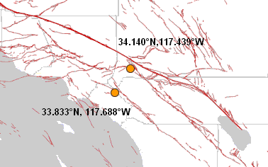
Earthquake Location Map. Source: USGS/EHP
Earthquake Details
Event Time: 2014-01-16 07:40:06 UTC
Location: 33.833°N, 117.688°W depth=8.5km (5.3mi)
Nearby Cities
- 12km (7mi) WSW of Corona, California
- 13km (8mi) ESE of Yorba Linda, California
- 19km ENE of Santa Ana, California
- 21km E of Anaheim, California
- 57km ESE of Los Angeles, California
Second Event
M3.2, 2014-01-16 09:50:03 UTC, 34.140°N 117.439°W depth=1.7km (1.1mi), 5km N of Fontana, California
Related Links
Posted in earthquake, Earthquake news, Significant Event Imagery, significant events | Tagged: california, earthquake 2014, Elsinore Fault Zone, Fontana, Salton Sea, San Andreas Fault, San Jacinto Fault Zone, Sierra Madre Fault Zone, Soledad, U.S. Earthquake | Leave a Comment »
Posted by feww on January 16, 2014
CLIMATE-RELATED DISASTERS
.
520 Counties across 16 States Declared Crop Disaster Areas due to Drought
The U.S. Department of Agriculture (USDA) has declared crop disaster for 520 counties across 16 states due to a recent drought.
The disaster areas, declared in 11 separate designations, cover more than 16.5% of all counties and county-equivalents in the U.S.
The latest crop disaster areas are in the following states
- Arizona
- Arkansas
- California (47 County-level crop disaster designations)
- Colorado (40 County-level crop disaster designations)
- Hawaii
- Idaho
- Kansas (52 County-level crop disaster designations)
- Louisiana
- Mississippi
- Nebraska
- Nevada
- New Mexico
- Oklahoma (36 County-level crop disaster designations)
- Oregon
- Texas (197 County-level crop disaster designations)
- Utah
The above list includes the disaster designation for 40 counties in 5 states posted earlier today.
Notes:
1. USDA trigger point for a countywide disaster declaration is 30 percent crop loss on at least one crop.
2. The total number of counties designated as agricultural disaster areas includes both primary and contiguous disaster areas.
3. The U.S. has a total of 3,143 counties and county-equivalents.
4. Several counties have been designated as crop disaster areas more than once due to multiple disasters occurring.
5. The disaster designations were approved by USDA between January 9 and December 18, 2013.
2014 Federal and Agriculture Disaster Declarations
Related Links
Posted in 2014 disaster calendar, 2014 disaster diary, 2014 global disasters, Climate Change, Global Disaster watch, global disasters, significant events | Tagged: Agricultural disasters, Arizona, Arkansas, california, Climate-Related Disasters, Colorado, Crops Disaster, Drought, drought conditions, Hawaii, Idaho, Kansas, Louisiana, Mississippi, Nebraska Nevada, New Mexico, Oklahoma, oregon, Texas, USDA, Utah | Leave a Comment »
Posted by feww on January 16, 2014
40 Counties in Five states Declared Agricultural Disaster Areas
The U.S. Department of Agriculture (USDA) has designated 40 counties in five states as crop disaster areas due to drought.
The Disaster Areas are:
- Colorado: Baca, Crowley, Kit Carson, Otero, Pueblo, Bent, El Paso, Las Animas, Phillips, Sedgwick, Cheyenne, Kiowa, Lincoln, Prowers, Yuma, Arapahoe, Custer, Elbert, Huerfano, Teller, Costilla, Douglas, Fremont, Logan, and Washington counties.
- Kansas: Cheyenne, Hamilton, Sherman, Wallace, Greeley, Morton, Stanton counties.
- Nebraska: Chase, Deuel, Perkins, Cheyenne and Dundy counties.
- New Mexico: Colfax and Union counties.
- Oklahoma: Cimarron County.
Notes:
1. USDA trigger point for a countywide disaster declaration is 30 percent crop loss on at least one crop.
2. The total number of counties designated as agricultural disaster areas includes both primary and contiguous disaster areas.
3. The U.S. has a total of 3,143 counties and county-equivalents.
4. A number of counties have been designated crop disaster areas more than once due to multiple disasters.
5. The disaster designations were approved by USDA between January 9 and December 18, 2013.
2014 Federal and Agriculture Disaster Declarations
Related Links
Posted in 2014 disaster calendar, 2014 disaster diary, 2014 global disasters, Climate Change, Global Disaster watch, global disasters, significant events | Tagged: Agricultural disasters, Colorado, Crops Disaster, Drought, drought conditions, Kansas, USDA | Leave a Comment »
Posted by feww on January 16, 2014
EXTREME WEATHER & CLIMATIC EVENTS
.
Temperatures could top 46°C in Adelaide, Australia: Forecast
Adelaide is currently the world’s hottest city at 43.3°C (110 degrees) at 03:00UTC, according to the Australian Bureau of Meteorology (BOM), and a maximum temp of 46°C (115 degrees) is forecast for the city today amid a blistering heatwave.
A persistent heatwave continues to smash temperature records and cause bushfires to rage out of control in parts of southeastern Australia Thursday.
Hundreds of blazes have been sparked by lightning storms across the “lost continent” and many are burning uncontrollably, as of posting.

Daily maximum temperature anomaly for Australiana. All temperature anomalies are calculated w.r.t the average over the 1961 to 1990 reference period. Source: BOM.
Climate Change and the Australian Bushfire Threat
The so-called Climate Council of Australia, a privately-founded organization, which includes former members of a a government-sponsored climate change watchdog that was dissolved last year by the PM Tony Abbott, has issued a report titled: “Climate Change and the Australian Bushfire Threat.” The following are excerpts from the report.
- Climate change is already increasing the risk of bushfires.
- Extreme fire weather has increased over the last 30 years in southeast Australia.
- In southeast Australia the fire season is becoming longer.
- Recent severe fires have been influenced by record hot, dry conditions. Australia has just experienced its hottest year on record in 2013.
- In the future, Australia is very likely to experience an increased number of days with extreme fire danger.
- Heatwaves have increased across Australia.
- The duration and frequency of heatwaves increased between 1971 and 2008, with the hottest days becoming even hotter.
- Record hot days and heatwaves are expected to increase in the future.
- Rising temperatures and heatwaves are one of the most direct consequences of climate change.
- Climate change is making extreme events even worse in terms of their impacts on people, property, communities and the environment.
- This is the critical decade. Australia must strive to cut emissions rapidly and deeply to join global efforts to stabilize the world’s climate and to reduce the risk of even more extreme events, including bushfires.
Most FIRE-EARTH readers would be familiar with the above facts, since they first learned about them as early as 2007.
Related Links
Posted in Climate Change, environment, Global Disaster watch, global disasters, Significant Event Imagery, significant events | Tagged: australia, EXTREME CLIMATIC EVENT, heatwave, temperature anomaly, temperature map | Leave a Comment »


