Archive for the ‘volcanoes’ Category
Posted by feww on July 30, 2009
Volcanic Activity Report: 22 July – 28 July 2009
VOW: Batu Tara

Batu Tara remained active in late July 2009. The Moderate Resolution Imaging Spectroradiometer (MODIS) on NASA’s Aqua satellite captured this photo-like image the volcano releasing a faint plume on July 27, 2009. The distinct segments of the plume suggest that the volcano has released ash and/or steam in pulses. The plume blows toward the northwest over the Flores Sea. NASA image courtesy MODIS Rapid Response Team, Goddard Space Flight Center. Caption by Michon Scott.

Batu Tara remained active in mid-May 2009. On May 17, 2009, as the Moderate Resolution Imaging Spectroradiometer (MODIS) on NASA’s Aqua satellite captured this image, the tiny volcanic island released a plume of ash and/or steam. The volcano’s plume forms a counter-clockwise arc north of the volcano. East of that plume is another, fainter plume, almost certainly of the same origin, blowing westward over the Flores Sea. NASA image courtesy MODIS Rapid Response Team, Goddard Space Flight Center. Caption by Michon Scott.
New activity/unrest:
Source: Global Volcanism Program (GVP) – SI/USGS Weekly Volcanic Activity Report
Notes:
KVERT reported that during 17-18 and 20-24 July seismic activity from Shiveluch was above background levels. According to news sources, an ash plume rose to an altitude of 7 km (23,000 ft) a.s.l. late on 25 July. Increased seismicity, powerful ash bursts, and avalanches were also reported.
Based on information from JMA, the Tokyo VAAC reported that on 22 July explosions from Sakura-jima produced plumes that rose to altitudes of 1.8-2.4 km (6,000-8,000 ft) a.s.l. and drifted E and SE. On 23 July and 27 July pilots observed ash plumes. (Source: GVP)
Ongoing Activity:
Related Links:
FEWW Links:
Posted in Global Volcanism, Volcanic Activity Report, volcanism, Volcano Hazard, volcanoes, VolcanoWatch | Tagged: Batu Tara, Kīlauea, Sakura-jima, Sarychev Peak, Suwanose-jima | Leave a Comment »
Posted by feww on July 25, 2009
Plume from Nyiragongo

Nyiragongo Volcano in the Democratic Republic of the Congo released a small plume on June 27, 2009, as the Advanced Land Imager (ALI) on NASA’s Earth Observing-1 (EO-1) satellite passed overhead.
NASA’s Moderate Resolution Imaging Spectroradiometer (MODIS) sensors detected hotspots on six different occasions between April 10 and May 4, 2009. The plume observed by ALI in late June may be a continuation of the low-level activity.
Nyiragongo is a stratovolcano—a steep-sloped structure made of alternating layers of solidified ash, hardened lava, and rocks released by previous eruptions. In contrast to the low profile of neighboring Nyamuragira, Nyiragongo rises to a height of 3,470 meters (11,384 feet) above sea level. Lava flows from Nyiragongo caused substantial casualties in 1977 and 2002. NASA image created by Jesse Allen, using EO-1 ALI data provided courtesy of the NASA EO-1 Team. Caption by Michon Scott. [Edited by FEWW.]
Related Links:
Posted in active volcanoes, lava flow, Nyamuragira, volcanic unrest, volcanoes | Tagged: Nyiragongo Unrest, Nyiragongo volcano, Plume from Nyiragongo, volcanic unrest, volcanism | Leave a Comment »
Posted by feww on July 3, 2009
VoW: Yellowstone Volcano
Location: 44.43°N 110.67°W
Summit Elevation: 2,805 m
Volcano Alert Level: NORMAL
Aviation Color Code: GREEN

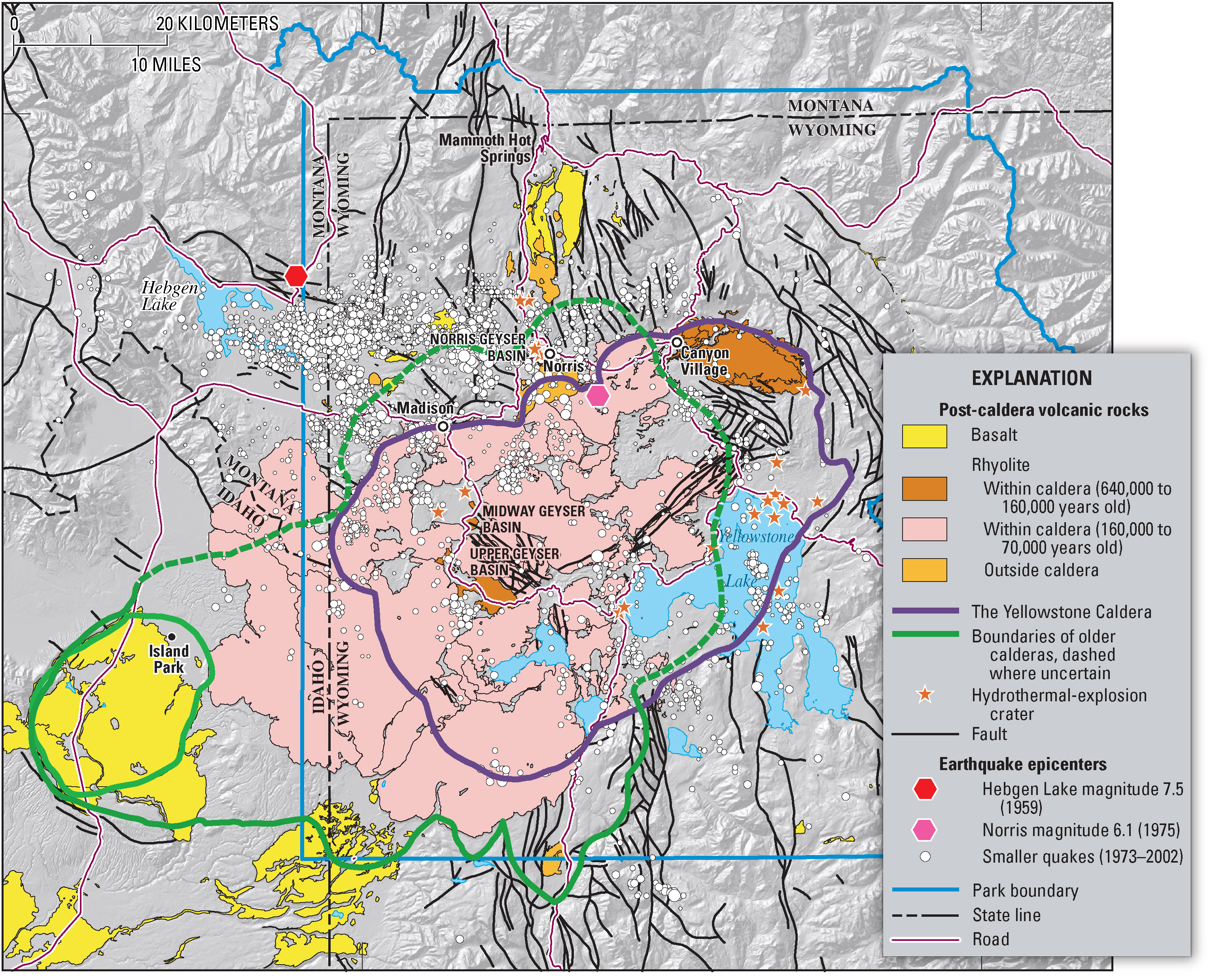
Remote sensor imagery of Yellowstone Caldera. Source: a frame-freeze picture from Yellowstone Volcano Due To Erupt

The rim of the Yellowstone Caldera. Source ESA (mirrored from http://www.yellowstonegis.utah.edu/home/home.html)
What’s brewing under the old rocks?
- Earthquake swarms are common at Yellowstone.
- Increased seismic activity at Yellowstone Lake in Yellowstone National Park in late December 2008 decreasing since January 8, 2009.
- Seismic activity could continue.
- The recent swarm is well above typical activity at Yellowstone, but not unprecedented.
- Earthquake swarms within the Yellowstone caldera typically occur with magnitudes of about 4.0.
- A swarm with about 3,000 events occurred in 1985 on the northwest rim of the caldera, lasting for three months, with largest earthquakes up to M4.9 recorded. (Source: Volcanoes USGS )

Yellowstone Lake showing location and times of the recent earthquakes from Dec. 27, 2008 (blue) to Jan. 8, 2009 (red). The M 3.0 and greater earthquakes are shown as stars, the smaller earthquakes are shown as circles. During the swarm, the earthquake locations appear to have moved north. For more information on the depths of the earthquakes, see the cross section from X to X’ below. (Source: Volcanoes USGS/ YVO )

The depth versus location of the Yellowstone Lake earthquake swarm from X to X’ on the Yellowstone Lake map. Earthquakes are shown from Dec. 27, 2008 (blue) to
Jan. 8, 2009 (red). The M 3.0 and greater earthquakes are shown as stars, the smaller earthquakes are shown as circles. (Source: Volcanoes USGS/ YVO )

Number of reviewed Yellowstone Lake earthquakes in six-hour and three-hour intervals from 12/27/08 to 01/06/09. The green line on the left figure gives the cumulative
number of earthquakes; the steep slopes correspond to increase in earthquake number. The red line in the figure on the right gives the cumulative moment, or energy; its sharp increase in the first few days is due to a greater number of large earthquakes with their greater energy release. The total cumulative moment is equivalent in energy to about one M 4.5 earthquake. Click on the image for a full-size version. (Source: Volcanoes USGS/ YVO )
What causes earthquakes at Yellowstone?
USGS / YVO cite a combination of geological factors including:
- Regional stress associated with normal faults such as the nearby Teton and Hebgen Lake faults
- Magmatic movements at depth (>7 kms)
- Hydrothermal fluid activity caused by boiling groundwater which is heated by magma.
However, YVO has not reported any anomalous changes in hot springs discharges, gas emissions …
In 2004 the Yellowstone caldera underwent period of accelerated uplift, clocking 7 cm/yr, or three times faster than in the recorded history; however the movement has now slowed down to a maximum rate of 4 cm/yr (or about 175 % of the pre-2004 records.)
The uplift is most noticeable at the White Lake GPS station, as has been discussed in our monthly YVO updates during the past year. As of late October 2007, the total uplift since 2004 at that location is about 17 cm. Chang and his colleagues credit the relatively rapid rise to recharge of magma into the giant magma chamber that underlies the Yellowstone Caldera. They also used numerical modeling to infer that the magma intruded about 10 km (6 miles) beneath the surface.

This interferogram provides a map view of ground movements at Yellowstone. Each color contour represents a line of equal uplift relative to the ENVISAT satellite between Sept. 2004 and Aug. 2006. The center of the uplift is an elliptical region stretching from the northeastern part of the Yellowstone Caldera (the dashed black line) to the southwest. This area of maximum uplift encompasses both Yellowstone’s resurgent domes, features long known for similar movements. During this time period, the north-rim uplift anomaly subsided (bullseye in the upper left part of the interferogram). The yellow lines are roads. The yellow triangles are locations of GPS stations with continuous data. The light blue lake within the caldera is Yellowstone Lake. Thin black lines are mapped faults. Figure courtesy of C. Wicks, USGS. Caption: USGS / YVO

Yellowstone caldera Map. USGS Click Image to Enlarge.

Source: USGS

Source: Yellowstone National Park.
Conclusion:
USGS / YVO: “At this time, there is no reason to believe that magma has risen to a shallow level within the crust or that a volcanic eruption is likely. ”
FEWW: Perhaps, a new mindset is needed to help understand the true nature, “utility function” and full range of all possible scenarios that might occur at the super volcano site. Let’s start looking at Yellowstone in the Big Picture frame. There may be a few sobering “surprises” in store!
Volcanic Activity Report: 24 June-30 June 2009
Source: Global Volcanism program (GVP) – SI/USGS Weekly Volcanic Activity Report
New activity/unrest:
NOTE: A small explosive eruption of Cleveland on 25 June prompted AVO to raise the Volcano Alert Level to Watch and the Aviation Color Code to Orange. An ash cloud that detached from the volcano was seen on satellite imagery moving S at an estimated altitude of 4.6 km (15,000 ft) a.s.l. No further activity was reported. On 27 June, AVO lowered the Volcano Alert Level to Advisory and the Aviation Color Code to Yellow. (Source: GVP)
Ongoing Activity:
- Arenal, Costa Rica
- Bagana, Bougainville
- Batu Tara, Komba Island (Indonesia)
- Chaitén, Southern Chile
- Dukono, Halmahera
- Galeras, Colombia
- Kilauea, Hawaii
- Rabaul, New Britain
- Redoubt, Southwestern Alaska
- Sakura-jima, Kyushu
- Sangay, Ecuador
- Santa María, Guatemala
- Shiveluch, Central Kamchatka (Russia)
- Slamet, Central Java (Indonesia)
- Soufrière Hills, Montserrat
- Tungurahua, Ecuador
Latest U.S. Volcano Alerts and Updates for July 03, 2009 0040 UTC
-
Redoubt Activity – Color Code YELLOW : Alert Level ADVISORY
-
Kilauea Activity – Color Code ORANGE : Alert Level WATCH
-
Cleveland Activity – Color Code – YELLOW : Alert Level – ADVISORY
-
Mauna Loa Activity – Color Code YELLOW : Alert Level ADVISORY
Redoubt Volcano Latest Observations: Local time: June 24, 2009 1705 AKDT (June 25, 2009 0105 UTC)
The eruption of Redoubt continues. Seismic activity remains low but above background levels.
Related Links:
Posted in Kīlauea, volcanism, Volcano Hazards, Volcano Status, volcanoes | Tagged: Chaiten, Cleveland, Sarychev Peak, Shiveluch, Volcano Watch | 2 Comments »
Posted by feww on June 25, 2009
Better late than never mate, goes the Australian saying
As for the reporting accuracy, close but no shrimps!

Sarychev Volcano moved to Japan (!) See section underlined in red. A condensed screen dump of the news URL at Australia‘s Melbourne Herald Sun site http://www.news.com.au/heraldsun/story/0,21985,25688161-24331,00.html
Even the Aussies should be entitled to accurate, prompt reporting!
Heaven knows we have criticized Earth Observatory often enough for holding on to images of public interest instead of releasing them instantly on Internet. However it took the Australian broadcaster nearly two weeks and a major political shift, taking the Sarychev Peak out of the hands of Russians and handing it over to the Japanese, to report the eruption.
Related Links:
Posted in reporting accuracy, Sarychev activity, Sarychev Peak erupted, volcanic eruption, volcanoes | Tagged: Australian News, Japan, KURIL ISLANDS, Russia, Sarychev Peak | Leave a Comment »
Posted by feww on June 25, 2009
Volcanic Activity Report: 17 June – 23 June 2009
Source: Global Volcanism program (GVP) – SI/USGS Weekly Volcanic Activity Report
New activity/unrest:
Notes:
The eruption from Sarychev Peak that began on 11 June continued through the 19th. Another explosive eruption on 15 June was followed by a plume that extended 360 km NW. Ash clouds from earlier explosions reached 13.7 km (45,000 feet) altitude. Ash emissions continued during 17-18 June.
During 21 June ash plumes from Rinjani rose to an altitude of 3 km (10,000 ft) and drifted 55 km N. (Source: GVP)
Volcano of the Week: Rabaul Caldera
Rabaul caldera, named after the town of Rabaul (town is built inside the caldera), is a large volcano in East New Britain, Papua New Guinea. Its Tavurvur and Vulcan cones erupted in 1994, devastating Rabaul and killing about a dozen people. It’s 1937 eruption killed more than 500 people.
Country: Papua New Guinea
Geographical region: New Britain
Volcano Type: Pyroclastic shield
Last Known Eruption: 2009 (continuing)
Summit Elevation: 688 m (2,257 feet)
Latitude: 4.271°S (4°16’15″S)
Longitude: 152.203°E (152°12’10″E)
Source: Global Volcanism Program (GVP)

Tavurvur volcano – part of Rabaul Caldera –– Papua New Guinea. Image Credit and Licensing details.

Rabaul Volcano on the northeastern end of New Britain captured by the Moderate Resolution Imaging Spectroradiometer (MODIS) on NASA’s Aqua satellite on April 3, 2009 releasing plumes of volcanic ash and steam. NASA image courtesy MODIS Rapid (!) Response Team, Goddard Space Flight Center.

The low-lying Rabaul caldera on the tip of the Gazelle Peninsula at the NE end of New Britain forms a broad sheltered harbor utilized by what was the island’s largest city prior to a major eruption in 1994. The outer flanks of the 688-m-high asymmetrical pyroclastic shield volcano are formed by thick pyroclastic-flow deposits. The 8 x 14 km caldera is widely breached on the east, where its floor is flooded by Blanche Bay and was formed about 1400 years ago. An earlier caldera-forming eruption about 7100 years ago is now considered to have originated from Tavui caldera, offshore to the north. Three small stratovolcanoes lie outside the northern and NE caldera rims of Rabaul. Post-caldera eruptions built basaltic-to-dacitic pyroclastic cones on the caldera floor near the NE and western caldera walls. Several of these, including Vulcan cone, which was formed during a large eruption in 1878, have produced major explosive activity during historical time. A powerful explosive eruption in 1994 occurred simultaneously from Vulcan and Tavurvur volcanoes and forced the temporary abandonment of Rabaul city. Photo by Wally Johnson, 1969 (Australia Bureau of Mineral Resources). Caption: GVP).
FEWW expects ongoing activity, punctuated by explosive eruptions by the volcano, for the rest of 2009 and possibly most of 2010.
Ongoing Activity:
- Arenal, Costa Rica
- Bezymianny, Central Kamchatka (Russia)
- Chaitén, Southern Chile
- Ebeko, Paramushir Island
- Galeras, Colombia
- Karymsky, Eastern Kamchatka
- Kilauea, Hawaii (USA)
- Koryaksky, Eastern Kamchatka
- Krakatau, Indonesia
- Llaima, Central Chile
- Rabaul, New Britain Redoubt, Southwestern Alaska
- Shiveluch, Central Kamchatka (Russia)
- Tungurahua, Ecuador
Latest U.S. Volcano Alerts and Updates for Wednesday, Jun 24, 2009 at 18:14:32 PDT
-
Redoubt Activity – Color Code ORANGE : Alert Level WATCH
-
Kilauea Activity – Color Code ORANGE : Alert Level WATCH
-
Veniaminof Activity – Color Code GREEN : Alert Level NORMAL
-
Mauna Loa Activity – Color Code YELLOW : Alert Level ADVISORY
Redoubt Volcano Latest Observations: Local time: June 24, 2009 1705 AKDT (June 25, 2009 0105 UTC)
The eruption of Redoubt continues. Seismic activity remains low but above background levels.
Related Links:
Posted in Papua New Guinea, Tavurvur, volcanism, volcanoes, Vulcan | Tagged: Rabaul caldera, Rinjani, Sarychev Peak, VolcanoWatch, weekly Volcano Watch | Leave a Comment »
Posted by feww on June 11, 2009
Volcanic Activity Report: 3 June – 9 June 2009
Source: Global Volcanism program (GVP) – SI/USGS Weekly Volcanic Activity Report
New activity/unrest:
FEWW Volcanic Activity Forecast:
FEWW Moderators forecast new volcanic activity/ unrest at 50 or more volcanoes throughout the rest of 2009.
List of the volcanoes to watch this year [and in 2010] includes:
Barcena (0.8), Socorro (0.8), Curacoa (0.99), Atitlán (0.65), Vesuvius (>0.6), Bazman (0.6), Mount Shasta (>0.5), Kaba (>0.5), Bandai (>0.5), Eastern Gemini Seamount or Mathew Island volcano (0.65), Fonualei (0.65), Mount Rainier (>0.5), Jan Mayen (>0.6), Thule (0.4), Sibayak (>0.5), Volcán Guallatiri (0.65), Taveuni (>0.4), two or more volcanoes on the island of Hokkaido (0.65), E-san (0.7), Oshima-Oshima (0.7), Komaga-take (0.65)… Protector Shoal (0.75), Thule Islands (0.7), Tina Kula (0.8)
Figure in the brackets indicate probability of activity/unrest.
For other forecasts see also:
Ongoing Activity:
- Batu Tara, Komba Island (Indonesia)
- Chaitén, Southern Chile
- Dukono, Halmahera (North Maluku province of Indonesia)
- Fuego, Guatemala
- Karymsky, Eastern Kamchatka (Russia)
- Kelut, Eastern Java (Indonesia)
- Kilauea, Hawaii (USA)
- Llaima, Central Chile
- Manam, Northeast of New Guinea (SW Pacific)
- Pacaya, Guatemala
- Popocatépetl, México
- Rabaul, New Britain
- Redoubt, Southwestern Alaska
- Sakura-jima, Kyushu
- Santa María, Guatemala
- Shiveluch, Central Kamchatka (Russia)
- Tungurahua, Ecuador
- Ubinas, Perú
Latest U.S. Volcano Alerts and Updates – Local time: June 10, 2009 22:05 AKDT (June 11, 2009 0605 UTC)
-
Redoubt Activity – Color Code ORANGE : Alert Level WATCH
-
Kilauea Activity – Color Code ORANGE : Alert Level WATCH
-
Mauna Loa Activity – Color Code YELLOW : Alert Level ADVISORY
Redoubt Volcano Latest Observations
2009-06-10 19:34:49 – The 2009 eruption of Redoubt continues. The seismic activity at Redoubt remains low, but above background levels. The webcam images from DFR and the Hut show a clear view of the dome and associated steaming. AVO continues to monitor Redoubt’s activity 24/7. (Source: AVO)
Related Links:
Posted in Indonesia, Redoubt Volcano, volcanic activity, volcanism, volcanoes | Tagged: Galeras, Karangetang, Sangeang Api, Slamet Volcanowatch, weekly Volcano news | Leave a Comment »
Posted by feww on June 9, 2009
NO Early Rest for Furious Galeras!
Galeras could erupt continually throughout 2009 and most of 2010 [FEWW]
Colombia’s Galeras volcano erupted twice in 24 hours, covering nearby villages in a blanket of volcanic ash.

Galeras Volcano. Photo source: Colombia Report. Image may be subject to copyright.

Galeras seen in this aerial photo (Undated). Source: Alaska Earthquake Information center. Image may be subject to copyright.
“An eruption of explosive nature has been registered,” the national geological institute Ingeominas said.
Although the earlier eruption on Sunday caused no damage, the authorities ordered 8,000 residents to evacuate the surrounding villages.
The second explosion on Monday was the 8th eruption one this year to shake the volcano, which is located in the Colombian department of Nariño near the town of Pasto, and close to the Ecuadorean border.
Currently the most active volcano in Colombia, the 4,276-meter-high volcano’s first historical eruption occurred on December 7, 1580. The volcano resumed activity in 1988 after 10 years of dormancy. It erupted in 1993, killing nine people, three tourists and six scientists who had descended into the volcano’s crater to conduct tests.

Galeras from Pasto (1993?). Photo by Stan Williams. Image may be subject to copyright.
Galeras activity in 2009
- 14 February 19:11 an eruption spewed ash SO2 and other and volcanic gases. (Red Alert, Level I). [Pasto was covered in ash, 8,000 people evacuated.]
- 20 February 07:05 spewed ashes. (Red Alert, Level I).
- 12 March 19:30, and 13 March 15:55 explosions were recorded (Orange Alert, Level II ).
- 13 March 15:55, eruption occurred spewing gas and hot ashes at 16:34 further emission was recorded. (Orange Alert, Level II).
- 24 April 07:32, two explosions were recorded. (Orange Alert, Level II).
- 29 April monitors recorded increase in seismic activity. (Orange Alert, Level II).
- 11 May 11:58, tectonic venting. (Orange Alert, Level II).
- 17 May 21:40, seismic activity recorded. (Orange Alert, Level II).
Eight of Colombia’s 15 volcanoes have erupted in the last 100 years, and three of them since 1990: Galeras, Nevado del Huila, and Nevado del Ruiz.
An explosive eruption ruptured the summit of Nevado del Ruiz on November 13, 1985, spewing about 20 million cubic meters of volcanic ash and rocks into the air. Forty-meter thick lahars traveling at velocities of up to 50 kilometers per hour destroyed the town of Armero 74 km away from the explosion crater, killing more than 23,000 people. [Source: USGS]

Related Links:
Posted in Explosive Eruption, Nevado del Huila, Nevado del Ruiz, volcanism, volcanoes | Tagged: Armero, colombia, Galeras Volcano, Nariño, Pasto | 3 Comments »
Posted by feww on June 5, 2009
FEWW ‘EarthModel’ Correctly forecast renewed enhanced activity at Mt Etna
See FEWW forecast: Earthquake Forecast: Southern Italy, Sicily
See GVP Report: ETNA Sicily (Italy) 37.734°N, 15.004°E; summit elev. 3330 m
INGV-CT reported that during 25-31 May the NW-SE-trending fissure E of the Etna summit craters continued (since 13 May 2008) to produce active lava flows to the N of the SE end of the fissure, along the W wall of the Valle del Bove. At least three lava flows were active. Elsewhere on the volcano, activity was restricted to degassing from the Northeast Crater, from the NW and SE Bocca Nuova vents, from the E flank of the Southeast Crater, and along summit fumarolic fields. The activity was observed directly and by utilizing surveillance cameras in Milo (about 11 km ESE).
Volcanic Activity Report: 27 May – 2 June 2009
Source: Global Volcanism program (GVP) – SI/USGS Weekly Volcanic Activity Report
New activity/unrest:
FEWW Volcanic Activity Forecast:
FEWW Moderators forecast new volcanic activity/ unrest at 50 or more volcanoes throughout the rest of 2009.
List of the volcanoes to watch this year [and in 2010] includes:
Barcena (0.8), Socorro (0.8), Curacoa (0.99), Atitlán (0.65), Vesuvius (>0.6), Bazman (0.6), Mount Shasta (>0.5), Kaba (>0.5), Bandai (>0.5), Eastern Gemini Seamount or Mathew Island volcano (0.65), Fonualei (0.65), Mount Rainier (>0.5), Jan Mayen (>0.6), Thule (0.4), Sibayak (>0.5), Volcán Guallatiri (0.65), Taveuni (>0.4), two or more volcanoes on the island of Hokkaido (0.65), E-san (0.7), Oshima-Oshima (0.7), Komaga-take (0.65)
Continued …
Figure in the brackets indicate probability of activity/unrest.
For other forecasts see also:
Ongoing Activity:
- Bagana, Bougainville
- Batu Tara, Komba Island (Indonesia)
- Chaitén, Southern Chile
- Dukono, Halmahe
- Etna, Sicily (Italy)
- Kilauea, Hawaii (USA)
- Llaima, Central Chile
- Nevado del Huila, Colombia
- Popocatépetl, México
- Rabaul, New Britain
- Redoubt, Southwestern Alaska
- Sakura-jima, Kyushu
- Shiveluch, Central Kamchatka (Russia)
- Soufrière Hills, Montserrat
- Tungurahua, Ecuador
- Ubinas, Perú
Latest U.S. Volcano Alerts and Updates for Thursday, Jun 4, 2009 at 23:33:10 PDT
-
Redoubt Activity – Color Code ORANGE : Alert Level WATCH
-
Kilauea Activity – Color Code ORANGE : Alert Level WATCH
-
Mauna Loa Activity – Color Code YELLOW : Alert Level ADVISORY
Related Links:
Posted in earthquake forecast, Etna, Hokkaido Volcanoes, Makian, volcanoes | Tagged: Slamet, volcanic activity, volcanism, volcano forecast, Volcano Watch | 2 Comments »
Posted by feww on May 21, 2009
Calm Before Volcanic Storm?
A quiet week for new volcanic activity, at least by recent standards. With Galeras excluded, for obvious reasons, there were only three new activities reported this week.
It’s interesting to note that the first mention of West Mata was apparently made in an entry on Vents Program. The entry 2008 Expedition to Lau Basin appears to be dated November 27, 2008, but later updated, posted by John Lupton, Chief Scientist. Perhaps Mr Lupton could clarify whether his organization plays by “Las Vegas Rules.”
Our Thanks also to Dr. Erik Klemetti for acknowledging this blog as the main source of his entry on the Saudi Arabian earthquake swarm. We would love to inspect Dr Klemetti’s doctoral thesis.
Volcanic Activity Report: 13 May – 19 May 2009
Source: Global Volcanism program (GVP) – SI/USGS Weekly Volcanic Activity Report
New activity/unrest:
VoW: Harrat Lunayyir (Volcanic Field)
 Western Arabia")
Harrat Lunayyir (Volcanic Field) Western Arabia. Image from Google Earth. Image may be subject to copyright.
Ongoing Activity:
- Batu Tara, Komba Island (Indonesia)
- Chaitén, Southern Chile
- Dukono, Halmahera
- Kilauea, Hawaii (USA)
- Redoubt, Southwestern Alaska
- Reventador, Ecuador
- Sakura-jima, Kyushu
- Shiveluch, Central Kamchatka (Russia)
- Soufrière Hills, Montserrat
- Suwanose-jima, Ryukyu Islands (Japan)
- Tungurahua, Ecuador
- Ubinas, Perú
- Ulawun, New Britain
Latest U.S. Volcano Alerts and Updates for Wednesday, May 20, 2009 at 18:54 PDT (May 21, 2009 01:54 UTC)
-
Redoubt Activity – Color Code ORANGE : Alert Level WATCH
-
Kilauea Activity – Color Code ORANGE : Alert Level WATCH
-
Veniaminof Activity – Color Code YELLOW : Alert Level ADVISORY
-
Mauna Loa Activity – Color Code YELLOW : Alert Level ADVISORY
Related Links:
Tonga Related Links:
Posted in Batu Tara, Chaiten, Harrat Lunayyir, volcanism, volcanoes | Tagged: Manam, San Cristóbal, Tonga volcanoes, VolcanoWatch, West Mata | 1 Comment »
Posted by feww on March 5, 2009
Latest U.S. Volcano Alerts and Updates for Thursday, Mar 5, 2009 at 06:40:05 PST
Volcanic Activity Report: 25 February-3 March 2009
Source: SI / USGS Weekly Volcanic Activity Report
New activity/unrest:
Volcano of the Week: Jan Mayen

Remote Jan Mayen Island, located in the Norwegian Sea along the Mid-Atlantic Ridge about 650 km NE of Iceland, consists of two volcanic complexes separated by a narrow isthmus. The large Beerenberg basaltic stratovolcano (Nord-Jan) forms the NE end of the 40-km-long island, which is ringed by high cliffs. Beerenberg is a large 2277-m-high glacier-covered stratovolcano with a 1-km-wide summit crater and numerous cinder cones that were erupted along flank fissures. It is composed primarily of basaltic lava flows with minor amounts of tephra. Historical eruptions at Beerenberg date back to the 18th century. The Sor-Jan group of pyroclastic cones and lava domes occupies the SW tip of Jan Mayen. The Holocene Sor-Jan cinder cones, tephra rings, and trachytic lava domes were erupted from short fissures with a NE-SW trend. Photo by Gernot Hecker, 2005 (Wikimedia Commons). Caption: GVP.
- Volcano: Jan Mayen
- Country: Norway
- Subregion: Jan Mayen Island
- Volcano Type: Stratovolcano
- Last Known Eruption: 1985
- Summit Elevation: 2,277 m (7,470 feet)
- Latitude: 71.08°N (71°5’0″N)
- Longitude: 8.17°W (8°10’0″W)
Ongoing Activity:
- Colima, México
- Galeras, Colombia
- Karymsky, Eastern Kamchatka
- Kilauea, Hawaii (USA)
- Redoubt, Southwestern Alaska
- Santa María, Guatemala
- Shiveluch, Central Kamchatka (Russia)
- Soufrière Hills, Montserrat
- Suwanose-jima, Ryukyu Islands (Japan)
- Tungurahua, Ecuador
Posted in Chaiten, Jan Mayen, Kīlauea, Redoubt, volcanoes | Tagged: active volcanoes, volcanic eruption, volcanic unrest, volcanism, Volcano Alerts | Leave a Comment »
Posted by feww on February 28, 2009
Lahar Burying Chaitén Town, Chile

A view shows a destroyed house at the flooded Chaiten town located some 1,220 km (758 miles) south of Santiago February 26, 2009. REUTERS/Victor Ruiz Caballero. Image may be subject to copyright.
Related Links:
Posted in chile, cone collapse, santiago, volcanism, volcanoes | Tagged: Chaitén town, ghost town, lahar, Mass Evacuation, Río Blanco | Leave a Comment »
Posted by feww on February 5, 2009
Volcanic Activity Report: 28 January-3 February 2009
From: SI / USGS Weekly Volcanic Activity Report
New Activity/Unrest:
Volcano of the Week: Ubinas

Volcán Ubinas, seen here from the west, is Perú’s most active volcano. A small, 1.2-km-wide caldera that cuts the top of Ubinas gives it a truncated appearance. The upper slopes of the stratovolcano steepen to nearly 45 degrees. The steep-walled, 150-m-deep caldera contains an ash cone with a 500-m-wide funnel-shaped vent that is 200-m deep. Holocene lava flows are visible on the volcano’s flanks, but historical activity, documented since the 16th century, has consisted of intermittent minor explosive eruptions. Photo by Norm Banks, 1988 (U.S. Geological Survey). Caption: GVP
Volcano Name: Ubinas
Country: Perú
Volcano Type: Stratovolcano
Last Known Eruption: 2008 (in or after)
Summit Elevation: 5672 m (18,609 feet)
Latitude: 16.355°S 16°21’18″S
Longitude: 70.903°W 70°54’11″W
Based on a SIGMET notice, the Buenos Aires VAAC reported that on 31 January an ash plume from Ubinas rose to an altitude of 6.7 km (22,000 ft) a.s.l. and drifted SW. Ash was not seen on satellite imagery.
Ongoing Activity:
- Barren Island, Andaman Is
- Chaitén, Southern Chile
- Fuego, Guatemala
- Karymsky, Eastern Kamchatka
- Kilauea, Hawaii
- Kliuchevskoi, Central Kamchatka (Russia)
- Pacaya, Guatemala
- Rabaul, New Britain
- Sakura-jima, Kyushu
- Santa María, Guatemala
- Shiveluch, Central Kamchatka (Russia)
- Soufrière Hills, Montserrat
- Tungurahua, Ecuador
- Ubinas, Perú
Posted in Asama, Redoubt, Volcanic Activity Report, volcanism, volcanoes | Tagged: Kliuchevskoi, Pacaya, peru, Tungurahua, Ubinas | Leave a Comment »
Posted by feww on February 3, 2009
Metis Shoal Submarine Volcano May Be Erupting
1. FEWW seismic analysis of Tonga Islands region in south Pacific Ocean (SPO) indicate that Metis Shoal, a submarine volcano located midway between the islands of Kao and Late (about 50 km NNE of Kao), may be about to erupt, or is currently undergoing a period of unrest.
2. Metis Shoal’s last known eruption occurred in 1995, which produced an island with a diameter of about 300 m and a height of 43 m after a solid lava dome was formed above the surface of water in SPO.
3. Since 1851 some 8 episodes of unrest have been recorded. In three, possibly five, of those occasions new islands were created (1858, 1967-68, 1979, 1995).
Metis Shoal
- Country: Tonga
- Region: Tonga Islands, SPO
- Volcano Type: Submarine volcano
- Last Known Eruption: 1995
- Summit Elevation: 43 m asl
- Latitude: 19.18°S 19°11’0″S
- Longitude: 174.87°W 174°52’0″W
4. Metis Shoal, a submarine volcano midway between the islands of Kao and Late, has produced a series of ephemeral islands since the first confirmed activity in the mid-19th century. An island, perhaps not in eruption, was reported in 1781 and subsequently was eroded away. During periods of inactivity following 20th-century eruptions, waves have been observed to break on rocky reefs or sandy banks with depths of 10 m or less. Dacitic tuff cones formed during the first 20th-century eruptions in 1967 and 1979 were soon eroded beneath the sea surface. An eruption in 1995 produced an island with a diameter of 280 m and a height of 43 m following growth of a lava dome above the surface. [Caption: GVP]

5. Waves break over Metis Shoal on February 19, 1968, more than a month after the end of a submarine eruption that began in December 1967 and produced an ephemeral island. Metis Shoal has produced a series of small islands during eruptions observed since the mid-19th century. Most recently, an eruption in 1995 produced a lava dome that built up to 43 m above sea level. Photo by Charles Lundquist, 1968 (Smithsonian Astrophysical Observatory). Caption: GVP

6. Map of the Tonga Islands, showing the island groups and location of Metis Shoal, which re-emerged as an island in June 1995. Source: GVP
Other Photos of Metis Shoal

7. Metis Shoal, sea level view. Source: MTU

8. Metis shoal, aerial view. Source: MTU

9. Metis Shoal aerial photo dated December 7, 2006. Source: GVP
Related Links:
Content of this post: 424 words, 9 paras/captions, 5 images, 1 list w/9 bullets
Posted in fumarolic activity, Submarine eruption, tephra, volcanic unrest, volcanoes | Tagged: Kao island, Metis Shoal volcano, south pacific ocean, Tonga Islands, volcanism | 7 Comments »
Posted by feww on October 10, 2008
1 – 7 October 2008
New Activity/Unrest:
Karangetang [Api Siau] Photo

Karangetang (Api Siau) volcano lies at the northern end of the island of Siau, north of Sulawesi. The 1784-m-high stratovolcano contains five summit craters along a N-S line. Karangetang is one of Indonesia’s most active volcanoes, with more than 40 eruptions recorded since 1675 and many additional small eruptions that were not documented in the historical record (Catalog of Active Volcanoes of the World: Neumann van Padang, 1951). Twentieth-century eruptions have included frequent explosive activity sometimes accompanied by pyroclastic flows and lahars. Lava dome growth has occurred in the summit craters; collapse of lava flow fronts has also produced pyroclastic flows. Photo by Volcanological Survey of Indonesia. Caption and details: GVP.
Volcano: Karangetang [Api Siau]
Country: Indonesia
Region: Sangihe Islands (Indonesia)
Volcano Type: Stratovolcano
Last Known Eruption: 2008
Summit Elevation: 1784 m 5,853 feet
Latitude: 2.78°N 2°47’0″N
Longitude: 125.40°E 125°24’0″E
Ongoing Activity:
- Anatahan, Mariana Islands (Central Pacific)
- Batu Tara, Komba Island (Indonesia)
- Chaitén, Southern Chile
- Karymsky, Eastern Kamchatka
- Kilauea, Hawaii (USA)
- Manam, Northeast of New Guinea (SW Pacific)
- Rabaul, New Britain
- Sakura-jima, Kyushu
- Shiveluch, Central Kamchatka (Russia)
- Soufrière Hills, Montserrat
- Suwanose-jima, Ryukyu Islands (Japan)
- Turrialba, Costa Rica
- Ubinas, Perú
This Weekly Volcanic Activity Report is a cooperative project between the Smithsonian’s Global Volcanism Program and the US Geological Survey’s Volcano Hazards Program.
Posted in Ol Doinyo Lengai, stratovolcano, Tanzania, volcanic activity, volcanoes | Tagged: Indonesia, Karangetang, Ol Doinyo Lengai, Sangihe Islands, volcanic unrest | Leave a Comment »
Posted by feww on July 26, 2008
Okmok Activity – Color Code RED : Alert Level WARNING
Okmok Volcano Activity Notifications
by AVO
The eruption of Okmok Volcano continued throughout this week with persistent ash emissions rising from 15,000 to 25,000 feet. From July 19 to July 20 the color code was increased to red in response to a more vigorous eruptive episode which produced ash to 30,000 feet. Photographs and an overflight by Alaska Volcano Observatory staff on July 20 and 21 confirmed the existence of multiple vigorous vents on the caldera floor.

Photo of the Okmok eruption, July 24, 2008, taken from Ft Glenn on the east flank of Okmok Caldera. Picture Date: July 24, 2008. credit : Lonnie Kennedy – Source: AVO
Seismicity was characterized by intermittent bursts of volcanic tremor early in the week. This changed to continuous mid-level volcanic tremor on July 23, which persists to the current time. Amplitude of tremor has been generally constant since July 21.
Although there has been little change in the eruption in the past several days, stronger explosive activity could resume at any time with little or no warning.
AVO Weekly Update – 2008-07-25 12:18:38
The eruption of Okmok Volcano continued throughout this week with persistent ash emissions rising from 15,000 to 25,000 feet. From July 19 to July 20 the color code was increased to red in response to a more vigorous eruptive episode which produced ash to 30,000 feet. Photographs and an overflight by Alaska Volcano Observatory staff on July 20 and 21 confirmed the existence of multiple vigorous vents on the caldera floor.
Seismicity was characterized by intermittent bursts of volcanic tremor early in the week. This changed to continuous mid-level volcanic tremor on July 23, which persists to the current time. Amplitude of tremor has been generally constant since July 21.
Although there has been little change in the eruption in the past several days, stronger explosive activity could resume at any time with little or no warning.
Cleveland Activity – Color Code ORANGE : Alert Level WATCH
Cleveland Volcano Activity Notifications
2008-07-25 12:18:38 – Weekly Update by AVO
Based on reports from fishing boats Cleveland Volcano began erupting at approximately 12:00 AKDT (20:00 UTC) on July 21, 2008. This eruptive episode is more intense than that observed over the past several years. Pilot reports and satellite data have documented a persistent low level ash emission from 10,000 to 20,000 feet throughout the week when the volcano was visible through clouds. A large thermal anomaly suggests the presence of an ongoing active lava flow.
Related Links:
Posted in Climate Change, environment, food, Global Warming, health, Tourism, Travel, volcanoes | Tagged: Alaska Volcano Observatory, ash plume, CLEVELAND VOLCANO, lava flow, Okmok, Okmok Caldera, Okmok Volcano Activity, Seismicity | 2 Comments »
Posted by feww on May 31, 2008
Chaitén Update # 3
Is Weary Chaitén Ready to Rest?
Chaitén continues to erupt, although a decline in the height of eruption column in the last two days has been reported. A decline also in its seismic activity is reducing the probability of larger explosive eruptions, though they are not entirely ruled out.
Air Lines Resume Flights Over Central and Southern Chile
Airlines resumed flights to most of southern Chile airports on Thursday after they were briefly suspended because of the high concentration of ash in the atmosphere.
Flights to Puerto Montt and Temuco remain on stand by until further notice; however, flights to Punta Arenas and Balmaceda have resumed.
Chaitén volcano started erupting May 2, after at least 9,000 years of dormancy.

Typical eruption column of Chaiten Volcano, Chile, on May 26, 2008, between stronger explosive activity. The circular caldera rim is 3 km (1.9 miles) in diameter, which was formed about 9,400 years ago. A lava dome that erupted sometime later is the knobby feature between the billowing ash and rim on the left. A new lava dome is growing in the caldera but it is out of view behind eruption column. U.S. Geological Survey photograph by J.N. Marso. Caption: Hawaiian Volcano Observatory.
Cerro Azul Volcano Erupts
Meanwhile the 1,700-meter high Cerro Azul volcano erupted on Thursday after 10 years of inactivity. Cerro Azul is located on Isabela, the largest of the Galapagos islands.

Cerro Azul volcano at the SW tip of Isabela Island. Photo by Tom Simkin (Smithsonian Institution). Image Maty be subject to copyright. See FEWW Fair Use Notice!
The Galápagos archipelago, a province of Ecuador, has a population of around 40,000 and is located the eastern Pacific Ocean at 525 nautical miles (972 km/604 miles) off the west coast of South America. The sparsely archipelago is home to “Galápagos,” the Spanish name for the Giant Land Tortoises that inhabit the islands.
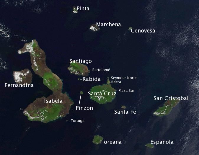
Satellite photo of the Galápagos islands (names of the visible main islands are overlayed).
Unlike the 1998 Cerro Azul eruption in which several giant tortoise were destroyed by molten lava, despite a rescue operation by helicopters, it is thought that the current eruption poses no danger to the animals.
Related Links:
.>.
Posted in Climate Change, energy, environment, food, geology, Global Warming, health, politics, Travel, volcanoes | Tagged: Cerro Azul volcano, Chaiten, ecuador, Galápagos, Galápagos archipelago, Giant Land Tortoises, Isabela, Pacific Ocean, Puerto Balmaceda, Puerto Montt, Puerto Temuco, Punta Arenas, seismic activity | Leave a Comment »


