Fire Earth

Earth is fighting to stay alive. Mass dieoffs, triggered by anthropogenic assault and fallout of planetary defense systems offsetting the impact, could begin anytime!

Archive for June, 2009

Seagrass in Crisis

Posted by feww on June 30, 2009

Seagrass is disappearing from the world’s oceans at an accelerating rate

A new study finds that 29 percent of the world’s known seagrass has disappeared since 1879 and the losses were rising exponentially.

Seagrasses—a unique group of flowering plants that have adapted to exist fully submersed in the sea—profoundly influence the physical, chemical, and biological environments in coastal waters, acting as ecological engineers (sensuWright and Jones 2006) and providing numerous important ecological services to the marine environment (Costanza et al. 1997). Seagrasses alter water flow, nutrient cycling, and food web structure (Hemminga and Duarte 2000). They are an important food source for megaherbivores such as green sea turtles, dugongs, and manatees, and provide critical habitat for many animals, including commercially and recreationally important fishery species.—A Global Crisis for Seagrass Ecosystems

seagrasses
Examples of seagrass meadows and associated animals. (a) Seahorse (Hippocampus sp.) in temperate Cymodocea nodosa meadow,Mediterranean Sea. Photograph: Gérard Pergent. (b) School of zebrafish (Girella zebra) over a temperate Posidonia australis meadow, Western Australia. Photograph: Gary A. Kendrick. (c) Manatee (Trichechus manatus) feeding in a tropical Thalassia testudinum meadow, Puerto Rico. Photograph: James Reid. (d) Green sea turtle (Chelonia midas) feeding in a tropical T. testudinum meadow, Yucatán. Photograph: Robert P. van Dam. Source: A Global Crisis for Seagrass Ecosystems

Seagrasses, which are found in coastal waters are vanishing at the rate of about 110 sq km a year since 1980, Reuters reported the study as saying. The report is to be published in the U.S. journal Proceedings of the National Academy of Sciences.

Seagrasses as ecological service providers and biological sentinels Seagrass meadows have important ecological roles in coastal ecosystems and provide high-value ecosystem services compared with other marine and terrestrial habitats (figure below; Costanza et al. 1997). For example, primary production from seagrasses and their associated macro- and microepiphytes rivals or exceeds that of many cultivated terrestrial ecosystems (Duarte and Chiscano 1999). Seagrasses also provide an enormous source of carbon to the detrital pool, some of which is exported to the deep sea, where it provides a critical supply of organic matter in an extremely food-limited environment (Suchanek et al. 1985).Much of the excess organic carbon produced is buried within seagrass sediments, which are hotspots for carbon sequestration in the biosphere (Duarte et al. 2005). The structural components of seagrass leaves, rhizomes, and roots modify currents and waves, trapping and storing both sediments and nutrients, and effectively filter nutrient inputs to the coastal ocean (Hemminga and Duarte 2000).—A Global Crisis for Seagrass Ecosystems

Only about 177,000 sq km of seagrasses are left globally.

The study by Australian and American scientists compares the losses to that of coral reefs, tropical rainforests and mangroves. It says seagrass meadows are “among the most threatened ecosystems on earth,”  blaming the loss on population growth, development, climate change and ecological degradation of the oceans.

“Seagrasses are sentinels of change” and the loss of seagrass was an indicator of a deteriorating global marine ecosystem. “Mounting seagrass loss reveals a major global environmental crisis in coastal ecosystems,” the report said.

seagrass ecosystem services - major loss mechs

Moreover, seagrasses can be considered as biological sentinels, or “coastal canaries.” Changes in seagrass distribution, such as a reduction in the maximum depth limit (Abal and Dennison 1996) or widespread seagrass loss (Cambridge and McComb 1984), signal important losses of ecosystem services that seagrasses provide. Seagrasses are sessile, essentially integrating the relevant water quality attributes, such as chlorophyll and turbidity, that affect the light reaching their leaves. Several features of seagrasses and seagrass meadows result in their particular importance in this regard.The widespread distribution of seagrasses throughout tropical and temperate regions (figure 2) allows better assessment of larger-scale trends than do other comparable coastal habitats, such as mangrove, corals, or salt marsh plants, which are limited to only one of these broad geographic regions. Seagrasses also live in shallow, protected coastal waters, directly in the path of watershed nutrient and sediment inputs, and are therefore highly susceptible to these inputs (figure 4), unlike mangrove forests (which are largely unaffected by water quality) or coral reefs (which occur farther away from the imputs).—A Global Crisis for Seagrass Ecosystems

Some 70 percent of all marine life in the ocean directly depends on seagrass, U.S.-based Seagrass Recovery said.

“Seagrass losses decrease primary production, carbon sequestration and nutrient cycling in the coastal zone. If the current rate of seagrass loss is sustained or continues to accelerate, the ecological losses will also increase, causing even greater ill-afforded economic losses,” said the study.

In addition to the well-documented causes of seagrass declines, other threats to these species are emerging. Over the last 20 years, introductions of nonnative marine species have arisen as a major environmental challenge for the world’s oceans (Carlton 1989). Such introductions are accelerating worldwide (Ruiz et al. 2000), a trend that will continue as the pathways for introductions widen and proliferate and as intervention lags (figure 6b; Naylor et al. 2001, Levine and D’Antonio 2003, Padilla and Williams 2004). At least 28 nonnative species have become established in seagrass beds worldwide, of which 64% have documented or inferred negative effects (figure 6b). The concern about this emerging threat to seagrass beds is that, whereas it is possible to reverse eutrophication or cease dredge-and-fill activities, it is virtually impossible to remove a nonnative species after establishment and spread (Lodge et al. 2006). Lastly, the rapid expansion of fish farming and other aquaculture practices (e.g., shellfish culture) can have serious consequences on local populations of seagrasses through physical disturbance or increased deposition of organic matter and nutrients (Marbà et al. 2006).—A Global Crisis for Seagrass Ecosystems

The preservation of seagrasses and their associated ecosystem services—in particular, biodiversity, primary and secondary production, nursery habitat, and nutrient and sediment sequestration—should be a global priority.We believe that the crisis facing seagrass ecosystems can be averted with a global conservation effort, and this effort will benefit not just seagrasses and their associated organisms but also the entirety of coastal ecosystems. —A Global Crisis for Seagrass Ecosystems

Related Links:

Posted in coastal zone, natural carbon sequestration, nutrient cycling, Primary production, seagrass meadows | Tagged: , , , , | 2 Comments »

Shiveluch spewes large plumes of ash

Posted by feww on June 30, 2009

Shiveluch volcano on the Kamchatka Peninsula ejects ash to a height of 7km

Shiveluch volcano on the Kamchatka Peninsula, Russia’s northernmost active volcano,  spewed out ash to a height of some 7,000 meters (23,000 feet), the local geophysics service reported on Monday.

The service had registered about 60 tremors within the area in the previous 24 hours.

“Some of them were followed by powerful ash bursts and avalanches,” a spokesman for the service said.

Shiveluch volcano erupted in December 2006. Local scientists expect the volcano to erupt explosively soon.

“Volcanic activity over the past two-three years has significantly altered the contour of the volcano, with the crater increasing in size by 50% and the slopes becoming far steeper.” RiaNovosti reported.

Related Links:

Previous Comments by FEWW

FEWW Volcanic Activity Forecast

Posted in Explosive Eruption, Kamchatka peninsula, Kamchatka volcanoes, Koryakski volcano, Russian volcano | Tagged: , , , , | Leave a Comment »

Airbus Crashes in Comoros

Posted by feww on June 30, 2009

Yemenia Airbus A310 with 153 People Crashes in Comoros

Yemenia-Airbus-A310A Yemen Airways (Yemenia) Airbus A310 with 153 people onboard crashed in the Indian Ocean near the archipelago of Comoros earlier today, according to an airline official.

Most of the 142 passengers  (total of 153 people onboard) were Comoran or French. There are no report of  survivors.


Yemenia Airbus A310. Source:  aviationexplorer.com. Image may be subject to copyright.


The downed Yemenia Airbus A310 passenger jet was flying from Sanaa, Yemen,  to Moroni, in the Comoros, carrying also a 11-strong crew, Reuters reported an official as saying.

The Comoros (Population of 800,000), which consists of four small volcanic islands (Anjouan, Grande Comore, Moheli and Mayotte) in the Mozambique channel, about 300 kilometers northwest of Madagascar, is not believed to have any sea rescue capabilities.

Comoros map

Map of the Comoros Islands. Original map: UN.

“We still do not have information about the reason behind the crash or survivors,” the deputy general manager for Yemenia operations, said.

“The weather conditions were rough; strong wind and high seas. The wind speed recorded on land at the airport was 61 kilometers an hour. There could be other factors.”

“Two French military aircraft have left from the islands of Mayotte and Reunion to search the identified zone, and a French vessel has left Mayotte,”the director general of Moroni International Airport was reported as saying.

“The plane has crashed and we still don’t know exactly where. We think it’s in the area of Mitsamiouli,” Comoros Vice-President Idi Nadhoim told Reuters.

“We think the crash is somewhere along its landing approach,” Mr Kassim a representative from regional air security body ASECNA said. “The weather is really not very favorable. The sea is very rough.”

Reuters sketch showing the flight path of downed Yemenia Airbus. Image may be subject to copyright.

Who owns Yemenia?

Yemenia is 51 percent owned by the Yemeni government and 49 percent by the Saudi Arabian government. Yemenia’s fleet includes four Airbus A310-300s, two Airbus A330-200s and four Boeing 737-800s, according to the airline site.

Airbus Crash Stats

If you really have to fly because your life depends on it [sic,] and if you are flying an Airbus, then fly on odd days of the month because the Airbus is statistically twice more likely to crash on even days!

The Next Airbus Crash?

The probability that the next major air disaster would involve an Air New Zealand Airbus has now increased to 0.78.

Related Links:

Posted in air new zealand, airline disasters, airline safety, comoros crash, french connection | Tagged: , , , , | 4 Comments »

Chaitén: A New Phase of Activity?

Posted by feww on June 29, 2009

Magnitude 5.3 quake strikes off the coast of Isen, Chile

A magnitude 5.3 quake struck off coast of Isen, Chile, at a depth of 10km on Monday. FEWW believes that the quake could be followed by more shocks, a number of which could be larger in magnitude, along the Chile Ridge, near the coast of Chile and about the subducting Nazca Plate. Additional seismic activity in the region could result in a new, more intense phase of activity in Chaitén, or prime other regional volcanoes for eruption.

Chaitén volcano as seen from the city of Chaitén (May 5, 2008)


Chaitén volcano ejects a plume of ash as seen from the city of Chaitén, 1,200km south from Santiago, Chile, on May 5, 2008. (ALVARO VIDAL/AFP/Getty Images). Image may be subject to copyright.

Earth’s Tectonic Plates with their movement vectors.


Detailed world map in English showing the tectonic plates with their movement vectors. For licensing details see: Attribution and Share-Alike

World geologic provinces


Source: USGS

Magnitude 5.3 OFF COAST OF AISEN, CHILE

Magnitude: 5.3
Date-Time: Monday, June 29, 2009 at 03:07:32 UTC
Location:  45.619°S, 76.605°W
Depth: 10 km (6.2 miles) set by location program
Region:  OFF THE COAST OF AISEN, CHILE
Distances:

  • 355 km (220 miles) W of Coihaique, Chile
  • 385 km (240 miles) SW of Castro, Chile
  • 1440 km (900 miles) SSW of SANTIAGO, Chile

Location Uncertainty: horizontal +/- 13.5 km (8.4 miles); depth fixed by location program
Parameters: NST= 40, Nph= 40, Dmin=733.6 km, Rmss=1.54 sec, Gp=133°, M-type=body wave magnitude (Mb), Version=6
Source: USGS NEIC (WDCS-D)
Event ID: us2009ilah

Earthquake Location

us2009ilah

Major Tectonic Boundaries: Subduction Zones -purple, Ridges -red and Transform Faults -green. Source: USGS.

Related Links:


Posted in COAST OF ISEN, Nazca Plate, oceanic tectonic plate, orogeny, Plate Tectonics | Tagged: , , , , | 1 Comment »

Beef recall, E.coli O157:H7 suspected

Posted by feww on June 29, 2009

20 people sickened by E.coli O157:H7

About 1/2 million pounds of beef recalled, E.coli O157:H7 contamination suspected

JBS-Swift Beef Co based in Greeley, Colorado, is expanding its June 24 recall  to a total of about 421,000 lbs of assorted beef products, USDA and the company said.

The recall is due to possible contamination by E.coli O157:H7 bacteria after about 20 people were sickened.  The recall includes meat products that were  processed on April 21 -22, 2009 and that have been sold nationally and internationally.

“The contamination may have come from further processing by other companies,” JBS spokesman said on Sunday.


Transmission electron micrograph of E. coli O157:H7 showing flagella. Pseudoreplica technique. Date: 1995. Photo Credit: Elizabeth H. White, M.S. / CDC

The recalled products are roasts and steaks rather than ground beef; however, the company cannot ruled out that  some of the beef may have been processed into ground products by intermediary resellers.

The products were  shipped to Arizona, California, Colorado, Florida, Illinois, Michigan, Minnesota, Nebraska, Oregon, South Carolina, Tennessee, Utah, Wisconsin as well as overseas destinations.

A potentially deadly bacteria, Escherichia coli O157:H7 is a strain of the bacterium Escherichia coli which causes foodborne illness. The infection often leads to bloody diarrhea, dehydration and occasionally to kidney failure, especially in young children, the elderly and persons with weak immune system.

The infections are associated with

  • Eating undercooked, contaminated ground beef
  • Drinking unpasteurized milk
  • Swimming in  contaminated water
  • Eating contaminated vegetables

In the US consumers can call 1-800-685-6328 for further assistance.


A colorized version of PHIL 7137 depicting a highly magnified scanning electron micrographic (SEM) view of a dividing Escherichia coli bacteria, clearly displaying the point at which the bacteria’s cell wall was dividing; Magnification 21674x.

Escherichia coli is a Gram-negative bacterium that normally colonizes the digestive tract of most warm-blooded animals, including human beings. E. coli are facultative in nature, which means that they can adapt to their environments, switching between aerobic, and anaerobic metabolic growth depending environmental stresses. One strain of E. coli, O157:H7, causes an estimated 73,000 cases of infection, and 61 deaths in the United States each year. Infection often leads to bloody diarrhea, and occasionally to kidney failure. Most illness has been associated with eating undercooked, contaminated ground beef. Person-to-person contact in families and child care centers is also an important mode of transmission. Infection can also occur after drinking raw milk and after swimming in or drinking sewage-contaminated water. Content Providers: CDC/ Evangeline Sowers, Janice Haney Carr. Photo Date: 2005. Photo Credit: Janice Haney Carr

What is Escherichia coli?

Escherichia coli (abbreviated as E. coli) are a large and diverse group of bacteria. Although most strains of E. coli are harmless, others can make you sick. Some kinds of E. coli can cause diarrhea, while others cause urinary tract infections, respiratory illness and pneumonia, and other illnesses. Still other kinds of E. coli are used as markers for water contamination—so you might hear about E. coli being found in drinking water, which are not themselves harmful, but indicate the water is contaminated. It does get a bit confusing—even to microbiologists.

What are Shiga toxin-producing E. coli?

Some kinds of E. coli cause disease by making a toxin called Shiga toxin. The bacteria that make these toxins are called “Shiga toxin-producing” E. coli, or STEC for short. You might hear them called verocytotoxic E. coli (VTEC) or enterohemorrhagic E. coli (EHEC); these all refer generally to the same group of bacteria. The most commonly identified STEC in North America is E. coli O157:H7 (often shortened to E. coli O157 or even just “O157”). When you hear news reports about outbreaks of “E. coli” infections, they are usually talking about E. coli O157. (Source: CDC.)

Related Links

This latest outbreak comes amid ongoing investigation into another Outbreak of E. coli O157:H7

Multistate Outbreak of E. coli O157:H7 Infections Linked to Eating Raw Refrigerated, Prepackaged Cookie Dough

Updated June 25, 2009

States Where Persons Infected with the Outbreak Strain of E. coli O157:H7 Live, United States, by State, March 1, 2009 to June 25, 2009

A map of the United States displaying cases of E. coli as of March 1, 2009 to June 25, 2009Click map to view a larger image.

Infections with the Outbreak Strain of E. coli O157:H7 By Date of Report to PulseNet

a chart showing, by month, infections related to E. coli O157:H7 reported to PulseNet.Click map to view a larger image.

CDC is collaborating with public health officials in many states, the United States Food and Drug Administration (FDA), and the United States Department of Agriculture Food Safety and Inspection Service (FSIS) to investigate an outbreak of E. coli O157:H7 infections.

As of Thursday, June 25, 2009, 69 persons infected with a strain of E. coli O157:H7 with a particular DNA fingerprint have been reported from 29 states. Of these, 46 have been confirmed by an advanced DNA test as having the outbreak strain; these confirmatory test results are pending on the others. The number of ill persons identified in each state is as follows: Arizona (2), California (3), Colorado (5), Connecticut (1), Delaware (1), Georgia (1), Iowa (2), Illinois (5), Kentucky (3), Massachusetts (4), Maryland (2), Maine (3), Minnesota (6), Missouri (1), Montana (1), North Carolina (2), New Hampshire (2), New Jersey (1), Nevada (2), Ohio (3), Oklahoma (1), Oregon (1), Pennsylvania (2), South Carolina (1), Texas (3), Utah (2), Virginia (2), Washington (6), and Wisconsin (1).

Ill persons range in age from 2 to 65 years; however, 64% are less than 19 years old; 73% are female. Thirty-four persons have been hospitalized, 9 developed hemolytic uremic syndrome (HUS); none have died. Reports of these infections increased above the expected baseline in May and continue into June.

Investigation of the Outbreak

In an epidemiologic study, ill persons answered questions about foods consumed during the days before becoming ill and investigators compared their responses to those of persons of similar age and gender previously reported to State Health Departments with other illnesses. Preliminary results of this investigation indicate a strong association with eating raw prepackaged cookie dough. Most patients reported eating refrigerated prepackaged Nestle Toll House cookie dough products raw.

E. coli O157:H7 has not been previously associated with eating raw cookie dough. CDC, the state health departments, and federal regulatory partners are working together in this ongoing investigation.

Clinical Features

Most people infected with E. coli O157:H7 develop diarrhea (often bloody) and abdominal cramps 2-8 days (average of 3-4 days) after swallowing the organism, but some illnesses last longer and are more severe. Infection is usually diagnosed by culture of a stool sample. Most people recover within a week, but some develop a severe infection. A type of kidney failure called hemolytic uremic syndrome (HUS) can begin as the diarrhea is improving; this can occur in people of any age but is most common in children under 5 years old and the elderly.

Advice to Consumers

The Food and Drug Administration (FDA) and the Centers for Disease Control and Prevention are warning consumers not to eat any varieties of prepackaged Nestle Toll House refrigerated cookie dough due to the risk of contamination with E. coli O157:H7. If consumers have any prepackaged, refrigerated Nestle Toll House cookie dough products in their home they should throw them away. Cooking the dough is not recommended because consumers might get the bacteria on their hands and on other cooking surfaces. The recall does not include Nestle Toll House morsels, which are used as an ingredient in many home-made baked goods, or other already baked cookie products.

Individuals who have recently eaten prepackaged, refrigerated Toll House cookie dough and have experienced any of these symptoms should contact their doctor or health care provider immediately. Any such illnesses should be reported to state or local health authorities.

Consumers should be reminded they should not eat raw food products that are intended for cooking or baking before consumption. Consumers should use safe food-handling practices when preparing such products, including following package directions for cooking at proper temperatures; washing hands, surfaces, and utensils after contact with these types of products; avoiding cross contamination; and refrigerating products properly.
Advice to Retailers, Restaurateurs, and Food-service Operators

Retailers, restauranteurs, and personnel at other food-service operations should not sell or serve any Nestle Toll House prepackaged, refrigerated cookie dough products subject to the recall.

For additional information


Posted in ecoli, ecoli bacteria, Ecoli infection, Greenley, meat recall | Tagged: , , , , | 8 Comments »

House Passes Emissions Bill

Posted by feww on June 27, 2009

Image of the Day:

Dream On!

Morbidly Obese: Cutting Small, Dreaming Big

The US House of Representatives has passed a climate change bill which seeks to cut emissions from 2005 levels by 17% by 2020. The bill was passed by a slim majority of 219-212 votes.

Morbidly Obese
FAT CHANCE! Morbidly obese dreaming of a cure on a 17% dietary cut! [Photo Source: Caliba. Image may be subject to copyright.]

Related Links:

Posted in Cap and Trade, CO2 Emissions, Energy and Commerce Committee, pollution control, too little too late | Tagged: , , , , | 4 Comments »

Eco-Terrorism and Dead Rare Sunfish

Posted by feww on June 27, 2009

Guilty of Eco-Terrorism: Tourists and Tour Operators

Eco-Tourists [sic] and Eco Tour Operators [sic] are systematically destroying the fragile marine environment in the south Pacific and Southern [Antarctic] oceans.

“Eco-tourists” love dead natural beauty, at least according to a short article in New Zealand Nelson Mail:

“Tourists being guided along Farewell Spit were mesmerised by more than just the area’s natural beauty yesterday.

“A large sunfish, about 2 metres long, and 2m wide from fintip to fintip, was spotted as Farewell Spit Eco Tours driver John Stevens was heading towards the spit with a busload of tourists.”

Dead Rare SunfishDo the eco-terrorists get a warm sensation rushing through their body knowing they are alive and can spot the dad rare sunfish, but the dead fish can’t see them?

Look What We Caught! [Original caption: STRANGE FIND.  Shelley Climo from the Farewell Spit Eco Tours office with the sunfish, found near Puponga township.] Photo: PADDY GILLOOLY/Farewell Spit Eco Tour (Via Nelson Mail). Image may be subject to copyright.

According to Farewell Spit Eco Tours owner Paddy Gillooly “the sunfish fascinated the tourists.”

“It was quite a good way to start the day. It’s one of the biggest ones I’ve seen.”

“The day before, tourists had seen a small dead minke whale that had washed up on the spit, and had since been washed away again.” The Nelson Mail said.

How very revealing!

“Mr Gillooly said he had seen about half a dozen sunfish washed up at the spit over the years. Because they could not manoeuvre easily, they could get washed into shallow water and stuck there.”

But do they all die of natural causes [sic]?

They were also a “very hard fish”, he said.

“Boaties and yachts sometimes [very often] run into them, and the yacht will [sometimes] come off second best.”

Source:  http://www.stuff.co.nz/environment/2542883/Sunfish-a-rare-sight

The world cannot survive with the impact of airline industry and tourism, but the “economy” can cope without the two!

Related Links:

Posted in eco-terrorism, Farewell Spit, marine ecology, sunfish, tasman sea massacre | Tagged: , , , , | Leave a Comment »

How Sarychev Peak Moved from Russia to Japan!

Posted by feww on June 25, 2009

Better late than never mate, goes the Australian saying

As for the reporting accuracy, close but no shrimps!

better late than never mate
Sarychev Volcano moved to Japan (!) See section underlined in red.
A condensed screen dump of the news URL at Australia‘s Melbourne Herald Sun site http://www.news.com.au/heraldsun/story/0,21985,25688161-24331,00.html

Even the Aussies should be entitled to accurate, prompt reporting!

Heaven knows we have criticized Earth Observatory often enough for holding on to images of public interest instead of releasing them instantly on Internet.  However it took the Australian broadcaster nearly two weeks and a major political shift, taking the Sarychev Peak out of the hands of Russians and handing it over to the Japanese, to report the eruption.

Related Links:

Posted in reporting accuracy, Sarychev activity, Sarychev Peak erupted, volcanic eruption, volcanoes | Tagged: , , , , | Leave a Comment »

VolcanoWatch Weekly [25 June 2009]

Posted by feww on June 25, 2009

Volcanic Activity Report:  17 June – 23 June 2009

Source: Global Volcanism program (GVP) – SI/USGS Weekly Volcanic Activity Report

New activity/unrest:

Notes:

The eruption from Sarychev Peak that began on 11 June continued through the 19th. Another explosive eruption on 15 June was followed by a plume that extended 360 km NW. Ash clouds from earlier explosions reached 13.7 km (45,000 feet) altitude. Ash emissions continued during 17-18 June.

During 21 June ash plumes from Rinjani rose to an altitude of 3 km (10,000 ft) and drifted 55 km N. (Source: GVP)

Volcano of the Week: Rabaul Caldera

Rabaul caldera, named after the town of Rabaul (town is built inside the caldera), is a large volcano in East New Britain, Papua New Guinea. Its Tavurvur  and Vulcan cones erupted in 1994, devastating Rabaul and killing about a dozen people. It’s 1937 eruption killed more than 500 people.

Country: Papua New Guinea
Geographical region: New Britain
Volcano Type: Pyroclastic shield
Last Known Eruption: 2009 (continuing)
Summit Elevation: 688 m  (2,257 feet)
Latitude: 4.271°S  (4°16’15″S)
Longitude: 152.203°E  (152°12’10″E)
Source: Global Volcanism Program (GVP)


Tavurvur volcano – part of Rabaul Caldera –– Papua New Guinea. Image Credit and Licensing details.

rabaul_amo_2009093
Rabaul Volcano on the northeastern end of New Britain captured by the Moderate Resolution Imaging Spectroradiometer (MODIS) on NASA’s Aqua satellite on April 3, 2009 releasing plumes of volcanic ash and steam. NASA image courtesy MODIS Rapid (!) Response Team, Goddard Space Flight Center.


The low-lying Rabaul caldera on the tip of the Gazelle Peninsula at the NE end of New Britain forms a broad sheltered harbor utilized by what was the island’s largest city prior to a major eruption in 1994. The outer flanks of the 688-m-high asymmetrical pyroclastic shield volcano are formed by thick pyroclastic-flow deposits. The 8 x 14 km caldera is widely breached on the east, where its floor is flooded by Blanche Bay and was formed about 1400 years ago. An earlier caldera-forming eruption about 7100 years ago is now considered to have originated from Tavui caldera, offshore to the north. Three small stratovolcanoes lie outside the northern and NE caldera rims of Rabaul. Post-caldera eruptions built basaltic-to-dacitic pyroclastic cones on the caldera floor near the NE and western caldera walls. Several of these, including Vulcan cone, which was formed during a large eruption in 1878, have produced major explosive activity during historical time. A powerful explosive eruption in 1994 occurred simultaneously from Vulcan and Tavurvur volcanoes and forced the temporary abandonment of Rabaul city. Photo by Wally Johnson, 1969 (Australia Bureau of Mineral Resources). Caption: GVP).

FEWW expects ongoing activity, punctuated by explosive eruptions by the volcano, for the rest of 2009 and possibly most of 2010.

Ongoing Activity:

Latest U.S. Volcano Alerts and Updates for Wednesday, Jun 24, 2009 at 18:14:32 PDT

  • Redoubt Activity – Color Code ORANGE : Alert Level WATCH

  • Kilauea Activity  –  Color Code ORANGE : Alert Level WATCH

  • Veniaminof Activity – Color Code GREEN : Alert Level NORMAL

  • Mauna Loa Activity – Color Code YELLOW : Alert Level ADVISORY

Redoubt Volcano Latest Observations: Local time: June 24, 2009 1705 AKDT (June 25, 2009 0105 UTC)
The eruption of Redoubt continues. Seismic activity remains low but above background levels.

Related Links:

Posted in Papua New Guinea, Tavurvur, volcanism, volcanoes, Vulcan | Tagged: , , , , | Leave a Comment »

Andres Strengthens to Hurricane Off Mexico PC

Posted by feww on June 24, 2009

Hurricane Andres swipes Mexico’s SW coast with 120 kph winds and rain

Tropical Storm Andres strengthened into the Pacific season’s first hurricane of 2009, toppling trees, flooding streets and homes and killing at least one as it battered Mexico’s southwestern coast with 120 kph winds.

Hurricane Andres Jun 24 Jun 2009 0100utc
Hurricane Andres frame freeze from GOES Imagery – IR Rainbow Enhancement Curve. NOAA/ NWS / NHC


Hurricane Andres frame freeze from GOES Floater Imagery – Funktop Enhancement – Updated every 30 mins. NOAA/ NWS / NHC

Tropical Storm Force Wind Speed Probabilities – 120 Hours

Coastal Watches/Warnings and 5-Day Track Forecast Cone

Hurricane ANDRES Public Advisory 9A

Hurricane Details

  • Source: NHC
  • Forecaster: Kimberlain/ Beven
  • Date and Time:  Jun 23,  2009  at 17:00 PDT
  • Warning area: SW coast of Mexico from Punto San Telmo to Cabo Corrientes.  [Interests elsewhere along the western coast of Mexico and the southern Baja peninsula should monitor the progress of Andres. ]
  • Current Location:  The center of hurricane Andres was located near latitude 19.0 n, longitude 105.6 w  or about 110 km west of Manzanillo Mexico and about 155 km south of Cabo Corrientes Mexico.
  • Category and Wind Speed:   Maximum sustained winds are estimated at 120 km/hr with higher gusts.  Andres is a category one hurricane on the Ssaffir-Simpson scale.  Weakening is forecast during the next day or two. [See Also FEWW Hurricane Scale]
  • Direction: Andres is moving toward the northwest at 20 km/hr.  This motion is expected to continue during the next day or so followed by a turn toward the west-northwest with a gradual decrease in forward speed.  On the forecast track Andres will continue passing very close to or over the coast of southwestern Mexico
    tonight.
  • Wind Force Extent:  Hurricane force winds extend outward up to 30 km from the center, tropical storm force winds extend outward up to 110 km. [Manzanillo Mexico recently reported a wind gust of 76 km/hr.
  • Estimated minimum central pressure: 988 mb (29.18 inches).

Notes: Andres is expected to produce total rain accumulations of 7 to 15 cm  (3 to 6 in) over portions of west-central Mexico with possible isolated maximum amounts of  20 cm (8 in).

Related Links:

Posted in Andres wind speed probability, Baja peninsula, Cabo Corrientes, MANZANILLO, Punto San Telmo | Tagged: , , , , | Leave a Comment »

The Really Holy Cow

Posted by msrb on June 23, 2009

Canadians breeding cows that burp less

Perhaps they’d now focus on breeding kids that eat less meat … for a win-win formula!


A Canadian cow is pictured in a field near Teulon, Manitoba in this July 28, 2006 file photo. REUTERS/Shaun Best. Image may be subject to copyright.

Stephen Moore, a professor professor of agricultural, food and nutritional science at the University of Alberta, is reportedly researching the genes responsible for methane produced by cows with a view to breed “more efficient, environmentally friendly cows.”

“We are working on producing diagnostic markers for efficient animals. We are looking at the next generation of technologies that will enable us to determine the genetics of an animal through a blood test or testing some hairs that you might pluck from the animal,” said Moore.

“To shrink cattle’s ecological footprint ranchers could also decrease the time cows are left standing in the field by getting animals to market sooner. That means breeding cattle that grow faster. Also, through breeding, cattle could become more efficient in converting feed into muscle and producing less methane and waste,” Reuters reported Moore as saying. [Souped up super booster prions anyone?]

Will the Canadian scientists now focus on breeding children that eat fewer cows, burn less fuels and export less oil, to boost their scientific contribution?

Related Links:

Posted in burp less cows, cattle's ecological footprint, eco kids, smart cows, Souped up super booster prions | Tagged: , , , , | Leave a Comment »

Another Airbus Near Disaster

Posted by feww on June 23, 2009

Another Airbus Incident

Qantas defends its Airbus fleet after 13 passengers injured

At least thirteen people were injured when a Qantas A330-300 carrying 206 passengers struck severe turbulence over Borneo on a flight from Hong Kong to Perth, AFP reported.

Qantas, the Australian flag-carrier, dismissed any link to other A330 accidents, especially to the Air France disaster on June 1, saying that the latest incident was caused by freak weather conditions.

qantas airbus a330-300
Qantas Airbus A330-300. (photo: GFDL)

“There is nothing to link the aircraft to anything untoward,” said company spokesman.

[Imagine Qantas deciding on the correct course of action. How much would they get for their second hand fleet of Airbus A330s? ]

As Flight QF68 dropped about 35 meters, sending passengers flying, when hit by turbulence as it flew over Malaysia some 4 hours into its flight.

“It appeared like we’d just dropped out of a 30-storey building,” said one passenger, as another described how a woman was flung into the plane’s ceiling.

“I was sitting at the exit door and I had this lady, (who) was waiting at the restroom and she flew up and hit the ceiling and came crashing down to the floor,” the passenger, reportedly told Fairfax radio.

“It was just a matter of a few seconds but it was really sudden and things went flying.”

At least thirteen people were treated neck and back injuries and bruises after the plane landed in Perth, AAP news agency said.

“The incident comes just 11 days after a cockpit blaze forced a Jetstar A330 to make an emergency landing, and also follows the Air France tragedy when 228 died in a mysterious accident involving the same model of plane.”

“Last October, a Qantas A330 went into two steep dives over Western Australia, causing several serious injuries and prompting an emergency landing, ” Asia One Travel said.

Qantas reportedly operates a fleet of ten  A330-300s and six Airbus A330-200s and is also the major shareholder and operator of the budget airline Jetstar.  While it is easy to understand why they would  dismiss any links between Monday’s incident and all the previous ones, it’s rather difficult to see what they might do after the next Airbus crash.

“There is no reason to link the incident to other recent in-flight incidents involving A330 aircraft,” Qantas said in a statement, adding an investigation was under way.

It is NOT known how they could have ruled out any link to recent Airbus incidents so quickly and prior to an investigation. On the other hand, if they are so confident of the Airbus A330 performance, why have they started a investigation?

Could it be that Qantas or the aviation authorities in Australia are conducting a kangaroo investigation?

The following is a list of Australia’s Airbus A330 [reported] incidents published by AAP. In view of public interest the list is mirrored below.
http://www.theaustralian.news.com.au/story/0,25197,25671665-2702,00.html

Incidents involving Australia’s fleet of A330 Airbus aircraft:

Jan 19, 2004 – A newly acquired Qantas A330-300 flying from Melbourne to Perth is forced to make an emergency landing in Adelaide after fumes leak into cabin, with seven crew members and two of the 274 passengers taken to hospital with nausea-like symptoms.

Aug 21, 2005 – Nine people, including two Australians, are injured during the evacuation of 178 passengers from a Perth-bound Qantas jet in Osaka, Japan, after a smoke sensor was activated in the aircraft’s hold.

Jan-June 2006 – A wasp infestation among Qantas aircraft, particularly A330s, at Brisbane Airport, causes three flights to be aborted during takeoff as well as a number of flight cancellations.

July 24, 2007 – More than 300 passengers are left stranded in Bali when a Bangkok to Melbourne Jetstar flight is forced to divert to Denpasar Airport after an engine failure.

Oct 8, 2008 – Almost 50 people are injured, some seriously, when a Qantas jet, with 303 passengers and a crew of 10 bound from Singapore to Perth, plunges up to 2,000 metres over Western Australia.

Nov 14, 2008 – A Qantas jet carrying 278 passengers from Sydney to Shanghai turns back after a weather radar malfunction on board.

Nov 29, 2008 – A Qantas jet serviced just days earlier and flying from Perth to Singapore has to turn back after the crew is forced to turn off one of its two engines when an engine oil warning light flashes. Qantas says inspections indicated a fault with the engine starter motor.

Dec 5, 2008 – A Qantas jet becomes bogged at Sydney airport as a towbar holding the aircraft fails and two of the jet’s wheels become stuck in the grass beside the taxiway.

Dec 29, 2008 – A Qantas jet flying from Perth to Singapore is forced to return to Perth after the autopilot disconnects at 36,000 feet about 500km northwest of Perth. Air safety authorities say the circumstances were similar to the October incident over WA.

Jan 28, 2009 – An A330 defence aircraft carrying about 80 Australian personnel and supplies to the Middle East is forced to make an emergency landing in Darwin after fumes filled the cabin. Three people were hospitalised and later recovered.

June 9, 2009 – Qantas announces it has received no safety directives for its A330 fleet following the May 31 crash of an Air France A330-200 that killed all 228 people aboard in the Atlantic Ocean.

June 10, 2009 – A fire in the cockpit of a Jetstar A330-300 carrying 186 passengers from Japan to Australia forces the pilot to make an emergency safe landing in Guam.

June 22, 2009 – Thirteen people are injured when a Qantas A330-300 carrying 206 passengers strikes severe turbulence over Borneo on a flight from Hong Kong to Perth. —AAP

Related Links are posted on the following page:

Posted in A330-300, Airline industry, jetstar, kangaroo investigation, qantas | Tagged: , , , , | 4 Comments »

Another NASA White Elephant Launch

Posted by feww on June 22, 2009

Lunar or Lunatic?  YOU decide!

Why Should All the Taxpayer Money Go to the Greedy Banks?

… When NASA can build white elephants and shoot them to the moon?


The NASA caption for the above image reads:

Does a permanently shadowed crater at the Moon’s South Pole harbor frozen water?

Who really cares, when it’s most of the country that’s running out of water!

Enough to supply a lunar outpost?

Are you **** serious? Between the war budget and NASA extravaganza, who’s going to feed the nation, provide health and education?

How much ultraviolet and cosmic radiation would astronauts be exposed to if they stayed on the moon for a week or longer?

If you don’t have an answer after 40 years of moon experience …

Where are the best—and worst—landing sites on the Moon? These are some of the questions that NASA plans to answer with its two new lunar missions.

That works to about $125 million dollars a question. Have you thought of designing a lottery machine that could predict the winning numbers…


Above : Artist rendering of the LRO spacecraft.

The point of these lunar missions is to collect the kinds of information we need to return astronauts to the moon. But the point of going to the moon is to learn about the Earth and our solar system (and ultimately, the universe). More than four billion years ago, as our solar system was forming, a planetary object roughly the size of Mars smacked into the Earth. The collision shattered the small planet and probably vaporized the upper layers of Earth’s surface. The debris—part Earth, part destroyed planet—remained in orbit around the Earth. Eventually, the debris aggregated into the Moon. If this theory, widely accepted among astrophysicists, is correct, then the formation of the Earth is inextricably tied to the formation of the Moon. And because the Moon’s surface has not been endlessly remodeled by plate tectonics, volcanoes, or erosion, it should be able to tell us things about how the Earth came to be that our planet itself never will.

Expensive theories indeed! Let’s see, the only way you can prove these “Beverly Hills” hypothesis is by being there on the moon, right? An the only people qualified to get there, of course are, let me guess, “the NASA experts.” And can’t achieve that without bailing out NASA, as it were, year in, year out. Right?

Launching an Open Challenge to NASA

FEWW has decided to launch the NASA [no holds barred] CHALLENGE and hereby challenges NASA executives to provide the following information:

Show the taxpayers without whose dollars you’d have to go out and work for your money

1. In what way(s) have the hundreds of billions of dollars spent by NASA in the past4 decades made the taxpayers home planet, Earth, a sustainable space base?

2. How much more money and how many more years would it take to do all of the things you say you could do on the moon and Mars?

3. How many of the taxpayers would you ever allow to escape to Mars or even the moon?

4. If NASA was to be wound up [or shut down] tomorrow and you were told to do something useful on this planet with the annual bailout money you currently receive, on what would you spend the existing NASA budget?

Related Links:

  • To the Moon! Lunar Missions Successfully Launch
  • NASA FY 2010 Budget Request Summary[NASA’s FY2010 budget request is in the amount of $18.686 billion “to advance Earth science, complete the International Space Station, explore the solar system and conduct aeronautics research. The budget request represents an increase of $903.6  million, about 5 percent, above the amount provided NASA in the FY 2009 Omnibus Appropriations Act.”]

To comment on the post go to: https://feww.wordpress.com/nasa-challenge/


Posted in LRO spacecraft, Lunar Base Ruse, Lunar Mission, nasa, NASA budget | Tagged: , , , , | Comments Off on Another NASA White Elephant Launch

US Midwest in Crosshairs of Climate Change

Posted by feww on June 21, 2009

Make a Radical Change, OR Look For a New Place to Live [sic]

Central US and the Midwest Could Be Running Out of Luck [and northern plains, too!]

NWS Warnings and Forecast – A Snapshot taken on June 21, 2009 at 13:58 UTC

NWS - 21 Jun 09
Hazardous Weather Outlook, gale and Hazardous Seas Warning currently threaten about 90 percent of the US by area. FEWW

Waves of thunderstorms caused up to 130, 000 outages. Affected areas include Illinois, Iowa, Kansas, and Michigan .

The storms produced torrential rain. The National Weather Service said parts of northern Illinois may have gotten up to 4 inches of rain Friday and Racine, Wis., had a 24-hour total of nearly 7 inches. —AP

High winds across central and eastern Kansas may have contributed to one fatality near McPherson, with another two people injured in Great Bend.

Storm Force Cuts Power

About 67,000 Commonwealth Edison customers remain without power early Saturday after two severe thunderstorms ripped through the Chicago area.—Chicago Sun Times.

APTOPIX Kansas Storms
Lightning strikes behind a windmill on a farm near Baldwin City, Kan., Monday, June 15, 2009. (AP Photo/Orlin Wagner). Image may be subject to copyright.

Record rainfall and Flight Delays at O’Hare International Airport

Flight delays at O’Hare on Friday were 90 minutes or more. More than 100 flights were canceled. At Midway, 45-minute delays and minor cancellations were reported. O’Hare had received 3.54 inches by 1 p.m. The National Weather Service said the previous record for June 19 was 1.79 inches in 1961.—AP

Meanwhile, thunderstorms rumbled across Indiana, producing hail and 67-mph winds and tornado warnings. Tornadoes tore through Wisconsin. Storms caused some structural damage in Michigan and Ohio.

How Many Trees are There in Chicago?

The department [of Streets & Sanitation in Chicago] received reports of 350 damaged trees, 61 traffic light outages, 25 damaged light poles, and 53 city light pole wires down, as of 8 p.m. —Chicago Sun Times.

Two storms system hit the central part of the U.S., spreading  across several states, bringing heavy rains, high winds and a half dozen tornadoes.

renewing flooding concerns in already soggy areas and leaving thousands of people without power.

Was it a tornado that did all this?

In Minnesota, an apparent tornado struck the town of Austin, uprooting trees, knocking down power lines and at least one person was reported with minor injuries. The National Weather Service said the storm sent debris flying, flipped cars on their sides and sent trees through roofs.

Heavy rain brought flooding concerns to areas of central North Dakota hit by flooding earlier this spring. South Dakota saw heavy rain, strong wind and hail, with two reports of funnel clouds in Stanley County.

A separate storm system that cut a wide swath across Kansas, Nebraska and Missouri knocked out power, damaged buildings and led to flash flooding. In the small Missouri town of Norborne, about an hour’s drive northeast of Kansas City, straight-line winds from a thunderstorm reached more than 74 mph…

In southwest Kansas winds reached up to 90 mph. About 22,000 residents were without power.—AP

Run those numbers by me, AGAIN!

A total of about 30 tornadoes and 370 storms hit across the nation on Wednesday alone, leaving behind extreme destruction and devastation. A twister was said to have  caused “millions of dollars in damage” in Austin, Minnesota.

High winds in Missouri twisted power poles and toppled trees while in Colorado, hail the size of marbles rained down on rural areas.
In Pittsburgh, flash floods drowned city streets and torrential rains overwhelmed storm drains, stranding even the rescue crews.
—AP

How do twister numbers compare?

  • About 840 tornadoes to date this year, compared with 1,305 in 2008 (through end of June).
  • April tally:  270 tornadoes compared with [the three-year average of 200.]
  • May total: 228  compared 461 tornadoes the same month last year.

FEWW said earlier this year could be one of the wettest on record.

A tornado reported west of Kenosha tore up some trees as severe storms moved through and produced downpours and street flooding Friday.

The storms Friday night hit less than 24 hours after severe weather and heavy rains caused flash flooding, so the new storms produced more flood problems, especially in Kenosha, Waukesha and Walworth counties.

…  heavy rains saturated the county with up to 6 inches falling in about an hour in some places.  The city of Racine had heavy rain that raised its 24-hour rainfall total to just under 7 inches. …  flooding along the Fox River had some vehicles floating in downtown Waukesha. Channel 3000

Related Links


Posted in flash floods, gale, thunderstorms, twisters, US tornadoes | Tagged: , , , , | 6 Comments »

VolcanoWatch Weekly [18 June 2009]

Posted by feww on June 20, 2009

Sarychev Peak Erupts

NASA Earth Observatory ISS020-E-09048
A fortuitous orbit of the International Space Station allowed the astronauts this striking view of Sarychev Volcano (Kuril Islands, northeast of Japan) in an early stage of eruption on June 12, 2009.

Astronaut photograph ISS020-E-9048 was acquired on June 12, 2009, with a Nikon D2XS digital camera fitted with a 400 mm lens, and is provided by the ISS Crew Earth Observations experiment and Image Science & Analysis Laboratory, Johnson Space Center. The image was taken by the Expedition 20 crew. The image in this article has been cropped and enhanced to improve contrast. Lens artifacts have been removed. The International Space Station Program supports the laboratory to help astronauts take pictures of Earth that will be of the greatest value to scientists and the public, and to make those images freely available on the Internet. Additional images taken by astronauts and cosmonauts can be viewed at the NASA/JSC Gateway to Astronaut Photography of Earth. Caption by M. Justin Wilkinson, NASA-JSC. Instrument: ISS – Digital Camera

sarychev_omi_2009167 - SO2

sarychev_omi_key-1

In mid-June 2009, Sarychev Peak Volcano on Matua Island in the northwest Pacific began a series of eruptions of large amounts of ash. According to atmospheric scientist Simon Carn, who is part of the science team for the Ozone Monitoring Instrument (OMI) on NASA’s Aura satellite, it was also almost certainly the largest sulfur dioxide event so far this year. This image shows average column sulfur dioxide concentrations between June 10 and 17, 2009, based on data from OMI. High concentrations of sulfur dioxide stretched westward from the volcano as far as Sakhalin Island and mainland Russia and eastward as far as Alaska.

Powerful volcanic eruptions can inject sulfate aerosols into the stratosphere. At these altitudes, the sulfates can linger for months or years, cooling the climate by reflecting incoming sunlight. Data from other satellites (such as CALIPSO) suggest that the volcanic plume reached altitudes of 10–15 kilometers, and perhaps as high as 21 km. NASA image courtesy Simon Carn, Department of Geological and Mining Engineering and Sciences, Michigan Technological University. Caption by Rebecca Lindsey. Instrument: Aura – OMI [Edited by FEWW.]

[If you thought that looks like a lot, imagine what 38,058,000,000,000.00 kg of CO2 looks like. more than 38,058 MMT of Co2 are released to the environment as a result of human activity: World Anthropogenic CO2 Emissions from Fossil Fuel Consumption Including Flaring, Cement Production, and Tropical Deforestation.

FEWW estimates that human activity emitted about 222 times more CO2 in 2008 than the total sum of  all carbon dioxide spewed from volcanic eruptions that year. ]

FEWW Comments:

FEWW cannot rule out the possibility that Sarychev Peak activity may continue unabated, with a pattern of eruptions not dissimilar to the Chaitén scenario.

Previous Comments by FEWW

FEWW Volcanic Activity Forecast

Volcanic Activity Report:  10 June – 16 June 2009

Source: Global Volcanism program (GVP) – SI/USGS Weekly Volcanic Activity Report

New activity/unrest:

Ongoing Activity:

Latest U.S. Volcano Alerts and Updates for Saturday, Jun 20, 2009 at 06:06:23 PDT

  • Redoubt Activity – Color Code ORANGE : Alert Level WATCH

  • Kilauea Activity  –  Color Code ORANGE : Alert Level WATCH

  • Veniaminof Activity – Color Code GREEN : Alert Level NORMAL

  • Mauna Loa Activity – Color Code YELLOW : Alert Level ADVISORY

Redoubt Volcano Latest Observations [2009-06-20 02:34:17]

The eruption of Redoubt continues. Seismic activity remains low but above background levels.  Webcam images of the summit are currently obscured by clouds and darkness. AVO continues to monitor Redoubt’s activity 24/7.

Related Links:

Posted in Chaiten, Climate Change, climate cooling, stratosphere, sulfate aerosols | Tagged: , , , , | Leave a Comment »

China Crumbles

Posted by feww on June 20, 2009

China is crumbling one mountainside, a mine, couple of cities, two dozen dams …  at a time

landslide in s-china chongqing-ali
A mountainside collapsed in the Chongqing region of southern China on June 5, 2009,  dropping about  12 million cubic meters earth and rocks onto a cluster of homes and an iron ore mine, and trapping dozens of people.  Xinhua News Agency reported 64 people as missing after the landslide.

The Advanced Land Imager (ALI) onboard NASA’s Earth Observing-1 (EO-1) satellite captured this photo-like image of the landslide on June 17, 2009. Mountain ridges run generally north-south through this area, and the June 5 landslide occurs on the eastern slope of the middle ridge shown in the image. A giant brown scar of bare land on an otherwise vegetated landscape, the landslide fans out toward the southeast. The mountainside collapse appears to affect two roads—one road running along the top of the ridge, which borders the landslide, and another road to the east, which the landslide has partially buried.

NASA image created by Jesse Allen, using EO-1 ALI data provided courtesy of the NASA EO-1 Team. Caption by Michon Scott. Instrument: EO-1 – ALI. [Edited by FEWW.]

Related Links:

Posted in Climate Change, heavy rains, human-enhanced disasters, iron ore mine, mine collapse | Tagged: , , , , | 1 Comment »

Never Mind the Enviro Impact of China’s Dams

Posted by feww on June 19, 2009

Dams on tributaries of China’s Yellow River could collapse anytime!

At least five newly built dams on branches of the Yellow River in arid Gansu province, northeast China face imminent collapse, just a year or so after they were built, said China Daily.

“Improper construction procedures, disqualified workers, embezzlement of construction funds and mismanagement of local water resource departments are threatening the safety of the dams, according to China Youth Daily.”

“One dike more than 80-m long and 20-m high, built in 2006 in Yuanxian county on the middle and upper reaches of the Yellow River, has developed a breach about 10 meters wide in the middle.According to nearby villagers, at least five newly-built dams are in very fragile condition, the newspaper said.”

The dams, paid for by the central government, are managed by the Ministry of Water Resource, under their “soil and water conservation project of the Yellow River” program.

“With a length of 5,464 km, the Yellow River, dubbed the “mother river” of China, suffers the most serious soil erosion in the world, especially along its middle and upper reaches. The average amount of mud and sand washed into the river every year reaches 1.6 billion tons.” China Daily said.

“Since 2003, China has poured a total of 83 billion yuan ($12 billion) into tackling soil erosion along the river and constructed more than 160,000 dams, according to Xinhua News Agency.

“As flood season approaches in July, August and September, China’s dam safety is coming under heavy pressure and inspections show many of them are not in good condition, Minister of Water Resources Chen Lei said last month.”

The Chilling Statistics:

  • Total number of dams, dikes and reservoirs in China: 91,500 units
  • Units in potential danger: 37,000  (or just over 40 percent of the country’s total)
  • Reinforced:  Under 3,650 dams
  • In need of immediate reinforcement: More than  7,600 Units
  • Chen Lei said that between 1999 and 2008,  some 59 dams were breached in China, 30 as a result of torrential rains and another 29 due to defects arising from poor construction.

Following quotes are from Ecology and Biodiversity, The University of Hong Kong: Conservation & Management of Freshwater Ecosystems ENVM8016 (2008)

  • North-south water transfer from Yangtze to Yellow River (& northern cities); seen as essential for >100 million people depending on the river
  • Yellow River did not reach the sea (no measurable flow) in 22 of the years between 1972 & 1997; duration of annual dryness in lower course was ~8 days in 1970s, 11 days in 1980s & 226 days in 1997
  • 3,382 dams on Yellow River can store >90% of mean annual discharge; since 1997 flow has been optimized (by controlled release) to ensure that some water flows to the sea throughout the year; involves difficult trade-offs due to absolute water scarcity
  • On large scales, dams reduce the downhill transfers of material from land to sea (e.g. amount & quality of water) & trap >30% of global sediment flux (retard SW silica inputs). Other effects could include blockage of uphill transfers of material.
  • Dams (& overfishing) can reduce or prevent upstream breeding migrations of salmon, with significant effects on stream & riparian ecosystems – as seen in NW North America

Related Links:

Posted in China, Drought in China, Official corruption, poor construction, soil and water conservation | Tagged: , , , , | 1 Comment »

New York Cognitive Dissonance

Posted by feww on June 19, 2009

New York Counts GHG?

New York Cognitive Dissonance: Keeping Wall Street alive AND showing concern for global climate change!


A carbon counting sign on the side of the Deutsche Bank building in New York, June 18, 2009, displays the running total amount of greenhouse gases in the atmosphere. REUTERS/Eric Thayer. IMAGE MAY BE SUBJECT TO COPYRIGHT.

Mauna Loa CO2 monthly mean data

May 2009, [Decimal date:  2009.375] – Monthly average:  390.18 ppm

Based on the above data, total atmospheric CO2 TODAY:

3,044,617,608,327.73 MT [3,044,617.61 MMT]

Combined impact of Nitrous Oxide (N2O), Methane (CH4) and CFC 12 ( CCl2F2) calculated at their full global warming potential: 30.59% of the CO2 Impact, or the CO2 equivalent of

931,380,216,898.77 MT CO2e [931,380,22 MMTCO2e]

Effective Total: 3,975,997,825,226.50 MTCO2e

[MT: Metric Tons;  MMT: Million Metric Tons; CO2e: Carbon Dioxide Equivalent ]

Related Links:

Posted in Fossil Fuel consumption, greenhouse gases, How much CO2, industrial pollution, World CO2 Emissions | Tagged: , , , , | 4 Comments »

EPA Declares PHE in Libby, Montana

Posted by feww on June 18, 2009

EPA finally declares a public health emergency in and near the Libby, Montana

EPA has declared a public health emergency in and near the city of Libby, Montana, where asbestos contamination in a vermiculite mine has left hundreds of people dead or sickened from lung diseases in the last century.

Libby Public Health Emergency

EPA announces a public health emergency at Libby Asbestos Superfund Site

On June 17, 2009, EPA Administrator Lisa Jackson issued a Public Health Emergency (PHE) finding at the Libby Asbestos Superfund site in northwest Montana. Over the past several years, hundreds of cases of asbestos-related disease have been documented in the communities of Libby and nearby Troy.

This is the first time EPA has made a finding under the Comprehensive Environmental Response, Compensation, and Liability Act (or Superfund) that conditions at a site constitute a Public Health Emergency. The finding recognizes the serious health impacts from asbestos contamination in Libby. EPA is working closely with the U.S. Department of Health and Human Services, which will help provide needed asbestos-related medical care to Libby and Troy residents.

The following is mirrored from EPA Site

Libby Asbestos: EPA announces a public health emergency at Libby Asbestos Superfund Site

Set in the northwest corner of Montana, 35 miles east of Idaho and 65 miles south of Canada, is the small town of Libby. The town lies in a picturesque valley carved by the Kootenai River and framed by the Cabinet Mountains to the south. Libby has population of less than 3,000, and 12,000 people live within a ten-mile radius. Libby is the Lincoln County seat. The community’s assets include clean water, beautiful scenery, and recreational opportunities such as fishing, hiking, hunting, boating and skiing.

EPA has been working in Libby since 1999 when an Emergency Response Team was sent to investigate local concern and news articles about asbestos-contaminated vermiculite. Since that time, EPA has been working closely with the community to clean up contamination and reduce risks to human health.

EPA Links:

Related Links:

Posted in EPA, Kootenai River, Libby Asbestos Site, Lincoln County, Montana | Tagged: , , , , | 1 Comment »

The Boy Who Had Nothing!

Posted by feww on June 17, 2009

Not Even Drinking Water

Image of the Day: If it Looks Like Raw Sewage …

Each year up to  4 million people die  from water related diseases, the leading cause of disease and death around the world.


A boy drinks water from a pond in Bule Duba village in the outskirts of Moyale, near the edge of Oroma and Somali regions of Ethiopia, June 12, 2009. Prolonged drought, lack of water and limited pasture have led to conflict between the Somali and Borena ethnic groups in southern Ethiopia which left hundreds of people dead in February this year. The International Federation of Red Cross and Red Crescent Societies (IFRC) says it needs some 100 million Swiss francs to prevent conflict, famine and epidemics as well as restore the livelihoods of 2.5 million people in the Horn of Africa. Image may be subject to copyright. REUTERS/Irada Humbatova

In Ethiopia, one in five children die before they reach the age of five from water-borne diseases. According to a report published in UK medical journa The Lancet, poor water sanitation and a lack of clean drinking water cause more deaths than war and war related action.

Posted in Borena ethnic groups, Cryptosporidium, Horn of Africa, protozoa Cryptosporidium, southern Ethiopia conflict | Tagged: , , , , | Leave a Comment »

US Impacts of Global Climate Change

Posted by feww on June 17, 2009

Global Climate Change: Impacts in the United States

According to a new report titled Global Climate Change: Impacts in the United States, impacts of climate change are “visible”  in the United States. The report says, “the choices we make now will determine the severity of its impacts in the future…” The  new federal report assesses the  current domestic impacts of climate change and forecasts some of the future trends.

“This new report integrates the most up-to-date scientific findings into a comprehensive picture of the ongoing as well as expected future impacts of heat-trapping pollution on the climate experienced by Americans, region by region and sector by sector,” said John P. Holdren, Assistant to the President for Science and Technology and director of the White House Office of Science and Technology Policy. “It tells us why remedial action is needed sooner rather than later, as well as showing why that action must include both global emissions reductions to reduce the extent of climate change and local adaptation measures to reduce the damage from the changes that are no longer avoidable.”

“Human induced climate change is a reality, not only in remote polar regions (and) in small tropical islands, but every place around the country — in our own backyards.” Said Jane Lubchenco, the administrator of the National Oceanic and Atmospheric Administration, NOAA, as she released the report.

The report is available online

View the powerpoint presentation [The White House Blog]

Key Findings

1. Global warming is unequivocal and primarily human-induced.
Global temperature has increased over the past 50 years. This observed increase is due primarily to human-induced emissions of heat-trapping gases. (p. 13)

2. Climate changes are underway in the United States and are projected to grow.
Climate-related changes are already observed in the United States and its coastal waters. These include increases in heavy downpours, rising temperature and sea level, rapidly retreating glaciers, thawing permafrost, lengthening growing seasons, lengthening ice-free seasons in the ocean and on lakes and rivers, earlier snowmelt, and alterations in river flows. These changes are projected to grow. (p. 27)

3. Widespread climate-related impacts are occurring now and are expected to increase.
Climate changes are already affecting water, energy, transportation, agriculture, ecosystems, and health. These impacts are different from region to region and will grow under projected climate change. (p. 41-106, 107-152)

4. Climate change will stress water resources.
Water is an issue in every region, but the nature of the potential impacts varies. Drought, related to reduced precipitation, increased evaporation, and increased water loss from plants, is an important issue in many regions, especially in the West. Floods and water quality problems are likely to be amplified by climate change in most regions. Declines in mountain snowpack are important in the West and Alaska where snowpack provides vital natural water storage. (p. 41, 129, 135, 139)

5. Crop and livestock production will be increasingly challenged.
Agriculture is considered one of the sectors most adaptable to changes in climate. However, increased heat, pests, water stress, diseases, and weather extremes will pose adaptation challenges for crop and livestock production. (p. 71)

6. Coastal areas are at increasing risk from sea-level rise and storm surge.
Sea-level rise and storm surge place many U.S. coastal areas at increasing risk of erosion and flooding, especially along the Atlantic and Gulf Coasts, Pacific Islands, and parts of Alaska. Energy and transportation infrastructure and other property in coastal areas are very likely to be adversely affected. (p. 111, 139, 145, 149)

7. Threats to human health will increase.
Health impacts of climate change are related to heat stress, waterborne diseases, poor air quality, extreme weather events, and diseases transmitted by insects and rodents. Robust public health infrastructure can reduce the potential for negative impacts. (p. 89)

8. Climate change will interact with many social and environmental stresses.
Climate change will combine with pollution, population growth, overuse of resources, urbanization, and other social, economic, and environmental stresses to create larger impacts than from any of these factors alone. (p. 99)

9. Thresholds will be crossed, leading to large changes in climate and ecosystems.
There are a variety of thresholds in the climate system and ecosystems. These thresholds determine, for example, the presence of sea ice and permafrost, and the survival of species, from fish to insect pests, with implications for society. With further climate change, the crossing of additional thresholds is expected. (p. 76, 82, 115, 137, 142)

10. Future climate change and its impacts depend on choices made today.
The amount and rate of future climate change depend primarily on current and future human-caused emissions of heat-trapping gases and airborne particles. Responses involve reducing emissions to limit future warming, and adapting to the changes that are unavoidable. (p. 25, 29)

Related Links:

Posted in climate system, heat-trapping pollution, livestock production, Mountain Snowpack, survival of species | Tagged: , , , , | Leave a Comment »

Exxon Mobile Court Orders Only Fraction of Damages

Posted by msrb on June 16, 2009

Federal Appeals Court Waters Down Exxon Valdez Oil Spill Damages 10 to 1

The Ninth U.S. Circuit Court of Appeals ordered Exxon Mobil Corp to pay litigants just over $500 million (plus interest), only a fraction of the original punitive damages stemming from Exxon Valdez disaster.


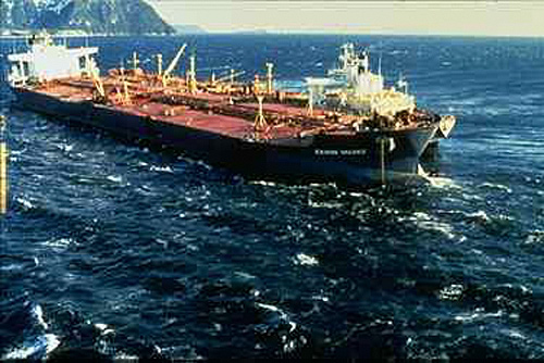
The Exxon Valdez, three days after the vessel ran aground on Bligh Reef. Photo: NOAA

A jury in 1996 had awarded total punitive damages of $5billion to  Alaska natives, business owners and other litigants against the 1989 Exxon Valdez massive oil spill off Alaska.

“The opinion issued on Monday by the Ninth U.S. Circuit Court of Appeals set the punitive damages figure, and determined the date from which the interest would run, after the U.S. Supreme Court ruled that the maximum ratio of punitive to compensatory damages is 1:1 under maritime law.” Reuters reported.


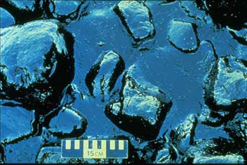
A few days after the vessel grounded, a storm pushed large volumes of  oil onto the rocky shores and beaches of Prince William Sound, Alaska. Pooled oil from the Exxon Valdez sits between rocks on the shore. Photo: NOAA

To add insult to injury, the court decided each party should bear its own attorney fees and court costs. This means the lions’ share of the money would go to the lawyers.

ExxonValdez Disaster
Grounded.  Photo courtesy of the Exxon Valdez Oil Spill Trustee Council. Exxon Valdez oil supertanker struck Bligh Reef in Prince William Sound (March 24, 1989), spilling an estimated 11 million gallons of crude oil in what was the largest environmental disasters in the US history. Only about a quarter of 26 monitored species have recovered to pre-spill numbers.

Interestingly the order regarding costs was a split decision by the judges. They want the litigants believe that there is at least  minority of judges which are more understanding.

The Exxon Valdez supertanker disaster, which contaminated about 1,250 miles of Alaska’s coastline, is considered the worst oil spill in the US history, with a clean-up price tag of about $2.5 billion.

Exxon Valdez spill map
Exxon Valdez Oil Spill Area.  Image Source: Ecotrust

Related Links:

Posted in Alaska's coastline, ExxonMobil, John D. Rockefeller, marine ecosystems, Standard Oil | Tagged: , , , , | 7 Comments »

Sarychev Peak Spews Two Plumes of Ash

Posted by feww on June 14, 2009

In the Majestic Earth’s Service

Sarychev Peak Spews Two Plumes of Ash, Helping to Balance Earth’s Energy Budget

FEWW Moderators believe that Earth is using some of her natural mechanisms to balance her energy budget, which has been forced into red by human activity. Over the coming months, Moderators will explain how the system works.

It’s a balancing act on a planetary level, and there’s a price to pay for using large-scale natural defense mechanisms. They don’t come cheap. Even IF successful on the planetary scale, the “trade-off,” if it can be so crudely termed, would be reflected in further erosion of the earth’s debilitated carrying capacity…

Watch this space for more information!

Activity at Sarychev Peak


Sarychev Peak located in NW end of Matua Island (Ostrov Matua) in Russia’s central Kurils reportedly spewed  ash plumes in two directions, west-northwesterly, and east-southeasterly. NASA’s Aqua satellite using its Moderate Resolution Imaging Spectroradiometer (MODIS) captured this image on June 12, 2009. Thanks to the age of modern technology (!), NASA’s MODIS Rapid Response Team at Goddard Space Flight Center rapidly posted the image on their website in under 48 hours.

Sarychev Peak (Kuril Islands, Russia)


A cloudcap obscurs the dramatic, 250-m-wide, steep-walled summit crater of Sarychev volcano, one of the most active volcanoes of the Kuril Islands. Sarychev occupies the NW end of Matua Island in the central Kurils in this NASA Space Shuttle image (with north to the top). The andesitic central cone was constructed within a mostly buried 3-3.5 km wide caldera; an older volcano forms the SE part of the island (lower right). The substantially higher SE rim forms the 1496 m high point of the island. Fresh-looking lava flows descend all sides of Sarychev Peak. Eruptions have been recorded since the 1760’s and include both quiet lava effusion and violent explosions. The largest historical eruption of Sarychev Peak in 1946 produced pyroclastic flows that reached the sea. The small island of Toporkovyi is partially visible at the right-center. Image: NASA Space Shuttle image ISS005-E-17796, 2002 (http://eol.jsc.nasa.gov/). Caption: GVP

Volcano Details
Country: Russia
Region: Kuril Islands
Volcano Type: Stratovolcano
Summit Elevation: 1,496 m
Latitude: 48.092°N (48°5’30″N)
Longitude: 153.20°E (153°12’0″E)
Source: Global Volcanism Program

Related Links:

[FEWW Volcanic Forecasts]

Posted in Earthquakes, Loyalty Arc, New Hebrides Arc, Okhotsk plate, volcano alert | Tagged: , , , , | 2 Comments »

5 Airbus, 1 Boeing Emergency Landings in 2 Days

Posted by feww on June 13, 2009

Six Passenger Jets have been Forced to Emergency Landing in 48 Hours

On June 2, 2009 the blog Co-Moderator MSRB wrote:

The Moderators have been expecting another Air New Zealand Airbus A320 to plunge into the sea (again), based on the airline’s safety statistics, but Air France beat the kiwis to it!

The probability remains that the next major air disaster would occur as a result of an Air New Zealand Airbus crashing into the sea [with a certainty of 0.74] —Airbus Must Come Clean

We have since learned about the following emergency landings involving Airbus jets:

Incident # 1.

Airbus jet makes emergency landing in Spain
Reported: Wed Jun 10, 2009 9:09am EDT
http://www.reuters.com/article/worldNews/idUSTRE55934F20090610

MADRID (Reuters) – An Airbus passenger plane run by Spanish tour group Iberworld was forced to make an emergency landing in the Canary Islands on Wednesday, airport operator AENA said.

The A320 airliner, en route from Gran Canaria island to Oslo, returned to the airport 10 minutes after take off due to engine problems, an AENA spokeswoman said.

No passengers were harmed and emergency procedures were followed without the need for the emergency services, AENA said. (Reporting by Emma Pinedo; Translation by Paul Day)

Incident # 2.

Mid-air fire in American Airlines Boeing 767 plane’s bathroom

Agence France-Presse
June 10, 2009 03:00pm

An American Airlines jet airliner with 210 people onboard was forced to land in eastern Canada when an electrical fire broke out in the bathroom, airport authorities reported.

There were no injuries and the passengers and crew are safe, said a spokesman Peter Spurway of Halifax airport. American Airlines Flight 64 was flying from New York to Zurich when the fire broke out.

”We received an advisory at about 7:48 pm Halifax Time,” Mr Spurway said.

The aircraft landed “without incident”, Mr Spurway said, and the passengers ”were evacuated to the ground by a set of air stairs”.

The emergency was caused by “fire in a fan motor in a mid cabin washroom”, he said.

Paramedics treated one person on the scene, but the patient did not need to be hospitalized, Spurway said.

http://www.news.com.au/travel/story/0,23483,25615521-5014090,00.html

Incident # 3.

Airbus makes emergency stop
Reported: June 10, 2009

MOSCOW – AN AIRBUS 340-300 jet heading for Beijing with 155 passengers on board was forced to make an emergency landing on Tuesday at a Moscow airport, Ris-Novosti reported.

The Air China jet, travelling from Milan, had suffered failure in one of its engines, said a spokeswoman for Moscow’s Sheremetyevo airport, quoted by the news agency.

‘The landing, at 9.07pm (1707 GMT, 12am Singapore time), went well,’ she said, adding that 85 of those on board would continue their journey to China later on Tuesday on an Aeroflot flight, with the remainder travelling on Wednesday. — AFP

http://www.straitstimes.com/Breaking%2BNews/Asia/Story/STIStory_388289.html

Incident # 4.

Russian Airbus makes emergency landing
Reported: June 11, 2009 at 1:47 AM

NOVOSIBIRSK, Russia, June 11 (UPI) — A cracked windshield
Thursday prompted the pilot of an Aeroflot Airbus to make an emergency landing in Novosibirsk, Russia, an official said.

A western Siberia transportation agency spokeswoman said there were no injuries reported among the 116 passengers and six crew members, RIA Novosti reported.

The Airbus 320 was en route from Irkutsk to Moscow when the incident occurred, the Russian news agency said. The cause of the windshield crack was being investigated.

http://www.upi.com/Top_News/2009/06/11/Russian-Airbus-makes-emergency-landing/UPI-64031244699245/

Incident # 5.

Cockpit Fire Forces Airbus A330 to Land

A Jetstar Airbus A330-200  with 203 people on board was forced into an emergency landing after a fire broke out in the cockpit.

The Jetstar Airbus A330-200, a similar model to the Air France Airbus flight 447 that crashed last week, was flying from Osaka, Japan to Australia when the cockpit caught fire.

The pilots put out the fire which broke out about four hours into the flight from Osaka to the Gold Coast in Queensland, Australia, before landing the plane in Guam, Jetstar was reported as saying, adding that all on board were unharmed.

“Smoke became evident in the cockpit and one of our pilots was required to use an extinguisher,” a Jetstar spokesman told Australia’s ABC News.

“We conducted an emergency diversion to Guam international airport where the aircraft landed without incident.”

He said the plane, which is two years old, would be held in Guam until the cause of the fire was established.

Flight JQ 20 left Kansai International Airport (OSAKA) about 21:00 Wednesday  bound for Perth with  186 adult passengers, four babies and a crew of 13 including 4 pilots. Most of the passengers were Japanese nationals, a report said.

Jetstar is a budget airline based in Australia and Singapore, and is part-owned by Australia’s national carrier, Qantas.

Incident # 6.

Emergency landing at Shannon
ELAINE EDWARDS
Last Updated: Friday, June 12, 2009, 16:54

An aircraft carrying 285 passengers made an emergency landing at Shannon airport this afternoon after what was reported to be a minor technical issue on board.

The Northwest Airlines Airbus A330 landed at about 1.20pm, a spokeswoman for Shannon airport said.

Emergency services at the airport were deployed in line with normal procedure, but the aircraft landed normally and all passengers disembarked safely.

Northwest Airlines said in a statement that flight 821 had diverted for “precautionary reasons due to a smoky odour in the forward galley”.

The aircraft landed normally and passengers deplaned into the terminal at the gate, the statement added.

“The aircraft is currently being reviewed by the local maintenance team. Northwest apologises to customers for the inconvenience caused. The safety and security of our passengers and crew is our number one priority.”

Shannon airport said the aircraft had been inspected and that it was due to continue its journey this evening.

http://www.irishtimes.com/newspaper/breaking/2009/0612/breaking46.htm

Each news item copyright by respective news agency.

Related Links:

Posted in Aeroflot, Air China jet, American Airlines, Iberworld, Northwest Airlines | Tagged: , , , , | 6 Comments »

Swine Flu Pandemic: Pharmaceuticals Payday

Posted by feww on June 11, 2009

WHO’s done it: Swine flu scam enters $600 billion phase!

Responding to pharmaceuticals business emergency, WHO ‘phinally’ declares swine flu ‘phandemic’

Here are some of the issues to consider:

1. Swine flu is a ‘phandemic’; it’s a ‘pandemic’  created by the World Health Organization (WHO), for pharmaceuticals. [See background, and scam  details.]

2. The recent influenza A(H1N1) viral mutation was most likely laboratory-engineered by/ for the multinational pharmaceuticals.

3. Flu viruses, laboratory-engineered or not, are pharmaceuticals’ ‘backbone’ business, especially when they’re elevated into a “pandemic.” They’re exploited as global, wholesale, long-term lucrative trade prospects. As WHO’s top flu expert Keiji Fukuda said: “When you’re talking about pandemic influenza, you are talking about a marathon, you are not talking about a sprint.”

4. The “flu experts” on whose advice the WHO supposedly acts, are pals of the same order eating from the same trough. If there are any ‘independent’ experts anywhere in the world, and don’t bet your life on finding one, they could only arrive at the same [desired] conclusion concerning a ‘pandemic’ because they’d be looking at the same set of flu data provided by the WHO.

5. To keep all other conditions normal, preventing  any  animosity/ rivalry between the pharmaceuticals and the other industries over potential loss of trade opportunities, and no doubt “acting on the recommendation of flu experts,”  the WHO has again advised its 193 member countries “not to close borders or impose travel restrictions to halt the movement of people, goods and services,” a call which has been approved and “echoed by U.N. Secretary-General Ban Ki-moon.

6. The languishing pharmaceuticals are not immune to the impacts of global economic slowdown. [Though they are clearly more enterprising than other industries, and can bank on the WHO to bail them out every time!]

7. When asked, Dr Thomas Frieden, new director of the U.S. Centers for Disease Control and Prevention, told a news conference: “This is not a surprise… It is expected based on the data.”

World now at the start of 2009 influenza pandemic – WHO Director-General Dr Margaret Chan

Her full statement to the press:

Dr Margaret Chan – Director-General of the World Health Organization

Ladies and gentlemen,

In late April, WHO announced the emergence of a novel influenza A virus.

This particular H1N1 strain has not circulated previously in humans. The virus is entirely new.

The virus is contagious, spreading easily from one person to another, and from one country to another. As of today, nearly 30,000 confirmed cases have been reported in 74 countries.

This is only part of the picture. With few exceptions, countries with large numbers of cases are those with good surveillance and testing procedures in place.

Spread in several countries can no longer be traced to clearly-defined chains of human-to-human transmission. Further spread is considered inevitable.

I have conferred with leading influenza experts, virologists, and public health officials. In line with procedures set out in the International Health Regulations, I have sought guidance and advice from an Emergency Committee established for this purpose.

On the basis of available evidence, and these expert assessments of the evidence, the scientific criteria for an influenza pandemic have been met.

I have therefore decided to raise the level of influenza pandemic alert from phase 5 to phase 6.

The world is now at the start of the 2009 influenza pandemic.

We are in the earliest days of the pandemic. The virus is spreading under a close and careful watch.

No previous pandemic has been detected so early or watched so closely, in real-time, right at the very beginning. The world can now reap the benefits of investments, over the last five years, in pandemic preparedness.

We have a head start. This places us in a strong position. But it also creates a demand for advice and reassurance in the midst of limited data and considerable scientific uncertainty.

Thanks to close monitoring, thorough investigations, and frank reporting from countries, we have some early snapshots depicting spread of the virus and the range of illness it can cause.

We know, too, that this early, patchy picture can change very quickly. The virus writes the rules and this one, like all influenza viruses, can change the rules, without rhyme or reason, at any time.

Globally, we have good reason to believe that this pandemic, at least in its early days, will be of moderate severity. As we know from experience, severity can vary, depending on many factors, from one country to another.

On present evidence, the overwhelming majority of patients experience mild symptoms and make a rapid and full recovery, often in the absence of any form of medical treatment.

Worldwide, the number of deaths is small. Each and every one of these deaths is tragic, and we have to brace ourselves to see more. However, we do not expect to see a sudden and dramatic jump in the number of severe or fatal infections.

We know that the novel H1N1 virus preferentially infects younger people. In nearly all areas with large and sustained outbreaks, the majority of cases have occurred in people under the age of 25 years.

In some of these countries, around 2% of cases have developed severe illness, often with very rapid progression to life-threatening pneumonia.

Most cases of severe and fatal infections have been in adults between the ages of 30 and 50 years.

This pattern is significantly different from that seen during epidemics of seasonal influenza, when most deaths occur in frail elderly people.

Many, though not all, severe cases have occurred in people with underlying chronic conditions. Based on limited, preliminary data, conditions most frequently seen include respiratory diseases, notably asthma, cardiovascular disease, diabetes, autoimmune disorders, and obesity.

At the same time, it is important to note that around one third to half of the severe and fatal infections are occurring in previously healthy young and middle-aged people.

Without question, pregnant women are at increased risk of complications. This heightened risk takes on added importance for a virus, like this one, that preferentially infects younger age groups.

Finally, and perhaps of greatest concern, we do not know how this virus will behave under conditions typically found in the developing world. To date, the vast majority of cases have been detected and investigated in comparatively well-off countries.

Let me underscore two of many reasons for this concern. First, more than 99% of maternal deaths, which are a marker of poor quality care during pregnancy and childbirth, occurs in the developing world.

Second, around 85% of the burden of chronic diseases is concentrated in low- and middle-income countries.

Although the pandemic appears to have moderate severity in comparatively well-off countries, it is prudent to anticipate a bleaker picture as the virus spreads to areas with limited resources, poor health care, and a high prevalence of underlying medical problems.

Ladies and gentlemen,

A characteristic feature of pandemics is their rapid spread to all parts of the world. In the previous century, this spread has typically taken around 6 to 9 months, even during times when most international travel was by ship or rail.

Countries should prepare to see cases, or the further spread of cases, in the near future. Countries where outbreaks appear to have peaked should prepare for a second wave of infection.

Guidance on specific protective and precautionary measures has been sent to ministries of health in all countries. Countries with no or only a few cases should remain vigilant.

Countries with widespread transmission should focus on the appropriate management of patients. The testing and investigation of patients should be limited, as such measures are resource intensive and can very quickly strain capacities.

WHO has been in close dialogue with influenza vaccine manufacturers. I understand that production of vaccines for seasonal influenza will be completed soon, and that full capacity will be available to ensure the largest possible supply of pandemic vaccine in the months to come.

Pending the availability of vaccines, several non-pharmaceutical interventions can confer some protection.

WHO continues to recommend no restrictions on travel and no border closures.

Influenza pandemics, whether moderate or severe, are remarkable events because of the almost universal susceptibility of the world’s population to infection.

We are all in this together, and we will all get through this, together.

Thank you. [NO, thank you! Really!]

Related Links:

[NOTE: IF you use the term ‘phandemic’ in the above context, quote this source!]

Posted in $600 billion scam, A (H1N1) virus, Double Psychology, flu vaccines, Swine Flu Mystery | Tagged: , , , , | 3 Comments »