Archive for the ‘earthquake damage’ Category
Posted by feww on April 6, 2014
SEISMIC HAZARD
WIDESPREAD DAMAGE
.
Earthquake affects more than 68,000 people, leaves 21,000 homeless
A magnitude 5.3 quake struck Yongshan County at a depth of 13 km, at 6:40 a.m. Saturday local time damaging at least 2,731 homes (75 destroyed), affecting more than 68,000, and leaving 21,000 displaced. At least 25 people were injured, authorities said.
The quake also damaged numerous other buildings including 48 schools across six towns, reported Xinhua.
Xiluodu Hydropower Project
“Yongshan is home to the Xiluodu hydropower project, China’s second largest hydropower station, only 15 km from the epicenter. Rumors have spread that the quake was caused by the power station,” said the report.
“The area has a history of quakes, [Zhang Jianguo of Yunnan Disaster Prevention Research Institute] said, and quakes caused by reservoirs usually have quite shallow epicenters, at a depth of around 4 km, while the epicenter of Saturday’s quake was 13 km deep.”

Original caption: A villager stands besides her damaged house in Yongshan County, southwest China’s Yunnan Province, April 5, 2014. At least 25 people were injured and 21,000 relocated when a 5.3-magnitude earthquake stuck Yongshan early on Saturday. (Xinhua/Hu Chao). More images…
Posted in earthquake, earthquake damage, Earthquake news, Global Disaster watch, global disasters, significant events | Tagged: China Earthquake, hydropower, Xiluodu hydropower project, Yongshan quake, Yunnan | Leave a Comment »
Posted by feww on April 2, 2014
SEISMIC HAZARD
LARGE EARTHQUAKE ALONG PERU-CHILE TRENCH
TSUNAMI WARNING
MASS EVACUATIONS
.
Major Earthquake Hits Northern Chile Coastal Area Triggering a Tsunami
10 Significant aftershocks have struck the quake zone including magnitudes 5.7, 6.2, 5.8, 5.7, 5.6, 5.5, 5.4, 5.3, 4.7, 5.2, 4.8, as of posting.
FIRE-EARTH Forecast for the Total Earthquake Energy associated with this Episode ≥ 0.25EJ. See Another significant aftershock… posted on March 17, 2014.
Earthquake Details [USGS/EHP]
Magnitude: 8.2Mw
Location: 19.642°S, 70.817°W
Depth: 20.1km (12.5mi)
Date/Time: 2014-04-01 at 23:46:46 UTC
Nearby Cities:
- 95km (59mi) NW of Iquique, Chile
- 139km (86mi) SSW of Arica, Chile
- 190km (118mi) SSW of Tacna, Peru
- 228km (142mi) SSE of Ilo, Peru
- 447km (278mi) SW of La Paz, Bolivia

Large earthquake strikes Chile, April 1, 2014. Source: USGS/EHP
- Tsunami waves are hitting Pisagua, Patache and Iquique, CHILE, as the authorities evacuate coastal areas.
- Multiple landslides have blocked several highways, hampering mass evacuations along coastal areas.
- The quake rattled buildings in Peru and Bolivian capital of La Paz, about 450km (278 miles) away.
Tsunami Warning/Watch
The first tsunami wave hit the coastal area within 45 minutes of the earthquake, said authorities. A tsunami warning has been issued for all of South and Central America’s Pacific coast.
The following bulletin was issued by the Pacific Tsunami Center.
PACIFIC TSUNAMI WARNING CENTER/NOAA/NWS
ISSUED AT 0131Z 02 APR 2014
THIS BULLETIN IS ISSUED AS ADVICE TO GOVERNMENT AGENCIES. ONLY
NATIONAL AND LOCAL GOVERNMENT AGENCIES HAVE THE AUTHORITY TO MAKE
DECISIONS REGARDING THE OFFICIAL STATE OF ALERT IN THEIR AREA AND
ANY ACTIONS TO BE TAKEN IN RESPONSE.
AN EARTHQUAKE HAS OCCURRED WITH THESE PRELIMINARY PARAMETERS
ORIGIN TIME – 2347Z 01 APR 2014
COORDINATES – 19.8 SOUTH 70.8 WEST
DEPTH – 10 KM
LOCATION – NEAR THE COAST OF NORTHERN CHILE
MAGNITUDE – 8.2
MEASUREMENTS OR REPORTS OF TSUNAMI WAVE ACTIVITY
GAUGE LOCATION LAT LON TIME AMPL PER
——————- —– —— —– ————— —–
MEJILLONES CL 23.1S 70.5W 0103Z 0.86M / 2.8FT 32MIN
MATARANI PE 17.0S 72.1W 0108Z 0.56M / 1.8FT 10MIN
TOCOPILLA CL 22.1S 70.2W 0109Z 0.42M / 1.4FT 10MIN
PISAGUA CL 19.6S 70.2W 0055Z 1.96M / 6.4FT 12MIN
ARICA CL 18.5S 70.3W 0021Z 0.98M / 3.2FT 36MIN
ANTOFAGASTA CL 23.7S 70.4W 0034Z 0.25M / 0.8FT 18MIN
PATACHE CL 20.8S 70.2W 0015Z 1.51M / 5.0FT 10MIN
IQUIQUE CL 20.2S 70.1W 0005Z 2.11M / 6.9FT 12MIN
LAT – LATITUDE (N-NORTH, S-SOUTH)
LON – LONGITUDE (E-EAST, W-WEST)
TIME – TIME OF THE MEASUREMENT (Z IS UTC IS GREENWICH TIME)
AMPL – TSUNAMI AMPLITUDE MEASURED RELATIVE TO NORMAL SEA LEVEL.
IT IS …NOT… CREST-TO-TROUGH WAVE HEIGHT.
VALUES ARE GIVEN IN BOTH METERS(M) AND FEET(FT).
PER – PERIOD OF TIME IN MINUTES(MIN) FROM ONE WAVE TO THE NEXT.
NOTE – DART MEASUREMENTS ARE FROM THE DEEP OCEAN AND THEY
ARE GENERALLY MUCH SMALLER THAN WOULD BE COASTAL
MEASUREMENTS AT SIMILAR LOCATIONS.
EVALUATION
SEA LEVEL READINGS INDICATE A TSUNAMI WAS GENERATED. IT MAY HAVE
BEEN DESTRUCTIVE ALONG COASTS NEAR THE EARTHQUAKE EPICENTER AND
COULD ALSO BE A THREAT TO MORE DISTANT COASTS. AUTHORITIES SHOULD
TAKE APPROPRIATE ACTION IN RESPONSE TO THIS POSSIBILITY. THIS
CENTER WILL CONTINUE TO MONITOR SEA LEVEL DATA TO DETERMINE THE
EXTENT AND SEVERITY OF THE THREAT.
FOR ALL AREAS – WHEN NO MAJOR WAVES ARE OBSERVED FOR TWO HOURS
AFTER THE ESTIMATED TIME OF ARRIVAL OR DAMAGING WAVES HAVE NOT
OCCURRED FOR AT LEAST TWO HOURS THEN LOCAL AUTHORITIES CAN ASSUME
THE THREAT IS PASSED. DANGER TO BOATS AND COASTAL STRUCTURES CAN
CONTINUE FOR SEVERAL HOURS DUE TO RAPID CURRENTS. AS LOCAL
CONDITIONS CAN CAUSE A WIDE VARIATION IN TSUNAMI WAVE ACTION THE
ALL CLEAR DETERMINATION MUST BE MADE BY LOCAL AUTHORITIES.
ESTIMATED INITIAL TSUNAMI WAVE ARRIVAL TIMES AT FORECAST POINTS
WITHIN THE WARNING AND WATCH AREAS ARE GIVEN BELOW. ACTUAL
ARRIVAL TIMES MAY DIFFER AND THE INITIAL WAVE MAY NOT BE THE
LARGEST. A TSUNAMI IS A SERIES OF WAVES AND THE TIME BETWEEN
SUCCESSIVE WAVES CAN BE FIVE MINUTES TO ONE HOUR.
LOCATION FORECAST POINT COORDINATES ARRIVAL TIME
——————————– ———— ————
CHILE IQUIQUE 20.2S 289.9E 0002Z 02 APR
ARICA 18.5S 289.7E 0011Z 02 APR
ANTOFAGASTA 23.3S 289.6E 0017Z 02 APR
CALDERA 27.1S 289.2E 0046Z 02 APR
COQUIMBO 29.9S 288.6E 0111Z 02 APR
VALPARAISO 33.0S 288.4E 0135Z 02 APR
TALCAHUANO 36.7S 286.9E 0219Z 02 APR
CORRAL 39.8S 286.5E 0251Z 02 APR
GOLFO_DE_PENAS 47.1S 285.1E 0403Z 02 APR
EASTER_ISLAND 27.1S 250.6E 0532Z 02 APR
PUERTO_MONTT 41.5S 287.0E 0546Z 02 APR
PERU MOLLENDO 17.1S 288.0E 0021Z 02 APR
SAN_JUAN 15.3S 284.8E 0039Z 02 APR
LA_PUNTA 12.1S 282.8E 0131Z 02 APR
TALARA 4.6S 278.5E 0218Z 02 APR
CHIMBOTE 9.0S 281.2E 0225Z 02 APR
PIMENTAL 6.9S 280.0E 0250Z 02 APR
ECUADOR LA_LIBERTAD 2.2S 278.8E 0239Z 02 APR
ESMERELDAS 1.2N 280.2E 0327Z 02 APR
BALTRA_ISLAND 0.5S 269.7E 0429Z 02 APR
COLOMBIA TUMACO 1.8N 281.1E 0346Z 02 APR
BAHIA_SOLANO 6.3N 282.6E 0417Z 02 APR
BUENAVENTURA 3.8N 282.8E 0433Z 02 APR
PANAMA PUERTO_PINA 7.4N 282.0E 0427Z 02 APR
PUNTA_MALA 7.5N 280.0E 0429Z 02 APR
PUNTA_BURICA 8.0N 277.1E 0441Z 02 APR
BALBOA_HEIGHTS 9.0N 280.4E 0645Z 02 APR
COSTA RICA CABO_MATAPALO 8.4N 276.7E 0441Z 02 APR
PUERTO_QUEPOS 9.4N 275.8E 0514Z 02 APR
CABO_SAN_ELENA 10.9N 274.0E 0531Z 02 APR
NICARAGUA SAN_JUAN_DL_SUR 11.2N 274.1E 0557Z 02 APR
PUERTO_SANDINO 12.2N 273.2E 0609Z 02 APR
CORINTO 12.5N 272.8E 0609Z 02 APR
EL SALVADOR ACAJUTLA 13.6N 270.2E 0628Z 02 APR
GUATEMALA SIPICATE 13.9N 268.8E 0642Z 02 APR
MEXICO PUERTO_MADERO 14.8N 267.5E 0649Z 02 APR
ACAPULCO 16.9N 260.1E 0711Z 02 APR
SALINA_CRUZ 16.5N 264.8E 0713Z 02 APR
HONDURAS AMAPALA 13.2N 272.4E 0655Z 02 APR
BULLETINS WILL BE ISSUED HOURLY OR SOONER IF CONDITIONS WARRANT.
THE TSUNAMI WARNING AND WATCH WILL REMAIN IN EFFECT UNTIL
FURTHER NOTICE.
THE U.S. NATIONAL TSUNAMI WARNING CENTER WILL ISSUE PRODUCTS
FOR ALASKA…BRITISH COLUMBIA…WASHINGTON…OREGON…CALIFORNIA.
See also:
FIRE-EARTH Earthquake Forecast for Chile (March 17, 2014) and the update posted at Another Significant Aftershock Strikes Coastal Chile.
FIRE-EARTH Models show a large earthquake could strike along Peru-Chile Trench in the coming weeks.
Tsunami Forecast: Large tsunami waves highly probable.
Forecast Details
- Magnitude: ≥8.2Mw
- Location: 23.6°S, 70.8ºW
- Depth: 30km
- Time: March 17 – April 29, 2014
- Probability of Occurrence: 0.75
- Total Earthquake Energy for the Episode ≥ 0.25EJ
Related Links
Posted in earhquake hazard, earthquake damage, earthquake forecast, Earthquake news, Earthquake Warning, Global Disaster watch | Tagged: chile, earthquake, FIRE-EARTH Chile Earthquake forecast, FIRE-EARTH earthquake FORECAST, Peru-Chile Trench, tsunami warning | Leave a Comment »
Posted by feww on January 20, 2014
EARTHQUAKE HAZARD
.
M6.2 strikes near Palmerston North, New Zealand
The quake was felt thoroughout New Zealand’s North Island, from Invercargill to Auckland, and as far south as Canterbury in the South Island, according to local reports.
The mainshock was followed by a swarm of aftershocks, with the largest measuring 3.7Mw, as of posting.
The quakes have caused damage to buildings and roads in the lower North Island between Wellington and Manawatu, said reports.
The quake was felt widely in the capital Wellington, leaving “people screaming and ducking for cover as items fell from shelves,” in a shopping mall, said a report.
The shock knocked power to thousands of customers in Tararua, Manawatu and Taranaki, according to the local power company.

Earthquake Location Map. Source: USGS/EHP
Earthquake Details [USGS/EHP]
- Event Time: 2014-01-20 @ 02:52:45 UTC
- Location: 40.634°S 175.776°E depth=28.0km (17.4mi)
- Nearby Cities
- 34km (21mi) SSE of Palmerston North, New Zealand
- 37km (23mi) NNE of Masterton, New Zealand
- 42km (26mi) E of Levin, New Zealand
- 71km (44mi) ENE of Paraparaumu, New Zealand
- 111km (69mi) NE of Wellington, New Zealand
Tectonic Summary
The January 20, 2014 M6.2 earthquake northeast of Masterton in the North Island of New Zealand is located approximately 115 km northeast of Wellington. The earthquake resulted from northeast-southwest oriented normal faulting 175 km to the west of the Hikurangi Trench, where the Pacific plate subducts westward beneath the North Island. At the latitude of this event, the Pacific plate moves towards the west-southwest with respect to the Australia plate at a rate of approximately 42 mm/yr. The faulting character, location and depth of this earthquake indicate it is an intraplate event either within Australia plate crust above the subducting Pacific plate, or within the interior of subducted Pacific slab, rather than a plate boundary event on the subduction zone thrust interface.
New Zealand experiences fairly frequent moderate-sized earthquakes; the region within 200 km of the January 20, 2014 event has experienced 35 earthquakes of M 5.5 or larger over the past century. The 2014 event is just a few kilometers to the east of a M 7.3 earthquake in March of 1934, and approximately 40 km southwest of two M6.2 and 6.4 earthquakes near Dannevirke in March and May of 1990, respectively. The 1990 events did not cause significant damage or fatalities. —USGS/EHP
For more information on earthquakes, including forecasts and warnings, search blog content.
Posted in earhquake hazard, earthquake damage, Earthquake news, earthquake report, Significant Event Imagery, significant events | Tagged: earthquake, earthquake 2014, new zealand, Palmerston North, Wellington | Leave a Comment »
Posted by feww on October 16, 2013
At least 108 people feared dead, 300 others injured, 2.9 million affected
Some 99 fatalities have been confirmed in the magnitude 7.1 earthquake that struck Bohol Island in central Philippines.
Ninety people were killed in Bohol, eight in Cebu and one in Siquijor, said the Philippine National Disaster Risk Reduction and Management Council (NDRRM) on Wednesday.
- Some 276 others were injured said NDRRM, including 166 in Bohol, 106 in Cebu.
- Up to a dozen people remain unaccounted for, according to local reports.
According to unconfirmed reports, at least 108 people were killed and 300 others injured in the quake.
A total of about 558,390 families, which translates to more than 2.84 persons have been affected in three island provinces—Bohol, Cebu and Siquijor.
Philippine authorities declared declared states of calamity in Bohol and Cebu provinces after the powerful quake struck on Tuesday.
The M7.1 quake, centered at 9.866°N, 124.011°E, struck at a depth of about 20km about 2km NE of Catigbian, on the island province of Bohol, Philippines at 00:12:32 UTC on Tuesday, October 15, 2013.
The deadly quake occurred about 619km (385mi) SSE of Manila, the Philippine capital, according to USGS/EHP.
Meantime, USGS/EHP has upgraded its Pager status to “Orange,” raising its estimate for the quake fatalities and estimated economic losses.
The ShakeMap has also been upgraded to Level IX, or “violent.”
Related Links
Posted in earthquake 2013, Earthquake aftermath, earthquake damage, Earthquake death, Global Disaster watch, global disasters, global disasters 2013 | Tagged: Balilihan quake, Bohol, Bohol earthquake, Bohol Island, Catigbian, Cebu, Cebu island, earthquake, earthquake damage report, Island of Fire, Philippine quake, Philippines quake, ShakeMap, Siquijor, State of Calamity | Leave a Comment »
Posted by feww on October 15, 2013
Powerful M7.1 Quake Causes Much Destruction in Central Philippines+
Philippine authorities have declared declared states of calamity in Bohol and Cebu Provinces after a powerful quake killed at least 80 people and left about 180 others injured, destroying or damaging scores of homes, buildings, historical churches, and causing widespread damage to public infrastructure across the famed tourist islands.
The M7.1 [revised by USGS/EHP] quake struck the island province of Bohol, about 2km NE of Catigbian, Philippines at a depth of about 20km [revised by USGS/EHP] at 00:12:32 UTC on Tuesday, October 15, 2013.
Centered at 9.866°N, 124.011°E, the deadly quake struck about 619km (385mi) SSE of Manila, according to USGS/EHP.
The mainshock was followed by large swarms of at least 400 aftershocks including 10 tremors measuring 5.0Mw or greater, as of posting.
The quake has affected tens of thousands of people, most of whom were left without electricity, tap water, communication or transportation links.
Half dozen bridges have collapsed, and many road have buckled due to the quake energy.
Related Links
Posted in earhquake hazard, earthquake, earthquake damage, Earthquake death, earthquake energy, Earthquake news, earthquake report, Global Disaster watch, global disasters, global disasters 2013 | Tagged: Balilihan quake, Bohol earthquake, Bohol Island, Catigbian, Cebu, Cebu island, earthquake, earthquake alert, earthquake damage report, Philippines quake, State of Calamity, State of Disaster | 2 Comments »
Posted by feww on October 15, 2013
UPDATE at 09:45UTC – October 15, 2013
- The quake death toll has reached a least 36, with about 100 others injured, or reported as missing both in Bohol and Cebu islands.
UPDATE at 06:00UTC – October 15, 2013
- Death toll from the quake has climbed to at least 24, with about 20 others injured, according to local sources.
- USGS has raised its estimate for shaking-related fatalities and economic losses to “Yellow alert.”
- At least 11 significant aftershocks have occurred, including 9 events on Bohol Island, as of posting.
UPDATE at 02:00UTC – October 15, 2013
PAGER: Green – Estimated Fatalities: Low, with some economic damage
ShakeMap: VIII – severe shaking causing heavy to moderate damage
- At least 8 people have been killed, according to local reports.
USGS EQ Hazard Program has revised its initial details of the quake as follows
- Magnitude: 7.1Mw
- Time: 2013-10-15 09:12:32 UTC+09:00
- Location: 9.866°N 124.011°E (2km NE of Catigbian, Philippines)
- Depth: 20.0km
At least 5 significant aftershocks have struck the region , as of UPDATE at 02:00UTC – October 15, 2013

UPDATED Earthquake Location Map. Source: USGS/EHP. Enhanced by FIRE-EARTH Blog.
Powerful Quake Strikes 5km E of Balilihan, Bohol Island, Philippines
The quake struck onshore at a depth of about 56.8km. The mainshock was followed by at least 2 significant aftershocks measuring 5.4 and 5.3Mw respectively, as of posting.
- The island province of Bohol is located in the Central Visayas region. Bohol is the tenth largest island of the Philippines with a population of about 1.5 million.
- Full extent of the damage, or injuries was unknown, as of posting, but there were reports of significant damage to roads and electricity lines throughout the region.
- NO tsunami warning or advisories issued.
Tsunami Evaluation
[Pacific Tsunami Warning Center/NOAA/NWS – Issued At 00:22UTC 15 Oct 2013]
No destructive widespread tsunami threat exists based on historical earthquake and tsunami data.
However, earthquakes of this size sometimes generate local tsunamis that can be destructive along coasts located within a hundred kilometers of the earthquake epicenter. Authorities in the region of the epicenter should be aware of this possibility and take appropriate action.
Earthquake Location Map

Earthquake Location Map. Source: USGS/EHP. Enhanced by FIRE-EARTH Blog.

Quake damage in Bohol. Image credit Charlotte Knowles

Santo Niño de Cebú RC Church damaged by the quake. Image credit: Franz Estores
More details to follow…
Posted in earthquake 2013, earthquake damage, Earthquake Hazard, Earthquake news, earthquake report, earthquake update, News Alert | Tagged: Balilihan quake, Bohol earthquake, Bohol Island, Catigbian, Cebu, earthquake, earthquake alert, Philippines quake | Leave a Comment »
Posted by feww on September 28, 2013
M6.8 strikes at a depth of 14.8km near Awaran
The quake has killed at least a dozen people and injured more than two dozen others, after it destroyed several houses in Nokjo district of Awaran, Baluchistan, according to early reports.
Meantime, death toll from an earlier earthquake that struck the region on September 24 has reached 515, with about 1,000 others injured, according to local officials.
The earlier quake, which was followed by several significant aftershocks, destroyed thousands of homes in villages near the epicenter, affecting more than 300,000 people in the sparsely populated region.
This earthquake was an aftershock which occurred approximately 30 km to the NNE of the September 24, 2013 M7.7 event, according to USGS/EHP.

EQ Location Map. Source: USGS/EHP. Enhanced by FIRE-EARTH Blog.
EQ Details [USGS/EHP]
- Event Time: 2013-09-28 07:34UTC
- Epicenter: 27.263°N, 65.587°E
- Depth: 14.8km (9.2mi)
- Nearby Cities
- 96km NNE of Awaran, Pakistan
- 135km NNW of Bela, Pakistan
- 811km ENE of Muscat, Oman
Tectonic Summary
The September 28, 2013 M6.8 earthquake in south-central Pakistan occurred as the result of oblique-strike-slip motion at shallow crustal depths. This earthquake is an aftershock located approximately 30 km to the north-northeast of the September 24, 2013 M7.7 event, which struck with a similar faulting mechanism. As with the September 24 event, the September 28 earthquake mechanism and location are consistent with rupture within the Eurasia plate above the Makran subduction zone. The event occurred within the transition zone between northward subduction of the Arabia plate beneath the Eurasia plate and northward collision of the India plate with the Eurasia plate. … Makran subduction zone has produced large devastating earthquakes and tsunamis. Read more…
Related Links
Posted in disaster areas, disaster calendar, disaster diary, disaster watch, disaster watch 2013, disaster zone, earthquake damage, Earthquake death, Earthquake Hazard, Earthquake Information, Earthquake news, Earthquake probability, earthquake report, earthquake update, Global Disaster watch, global disasters, global disasters 2013, News Alert, Significant Earthquakes, Significant Event Imagery, significant events, significant geophysical disturbances | Tagged: Arabia plate, Awaran, Awaran quake, Baluchistan, Baluchistan province, Deadly Quake, earthquake 2013, EQ Location Map, Eurasia plate, Makran subduction zone, Nokjo town, Pakistan, Pakistan Earthquake | Leave a Comment »
Posted by feww on September 25, 2013
Toll from Pakistan quake rises
About 1,000 people were killed or injured after a powerful 7.7Mw quake on Tuesday struck Baluchistan region in SW Pakistan, reports said.
“Two hundred and eighty five bodies have so far been recovered in the Awaran district,” the deputy commissioner of Awaran, the worst affected area, told Reuters.
“And 42 bodies were found in the neighboring Kech district,” he added.
Related Links
Other Global Disasters/ Significant Events
Typhoon USAGI Kills Dozens in China
Typhoon USAGi has killed at least 29 people since making landfall in Shanwei City, in south China’s Guangdong Province on Sunday, authorities said.
As of Tuesday evening, the typhoon had affected 9.23 million people, forcing more than 530,000 residents in the province to relocate, said a report.
USAGI has ruined 152,000 hectares of crops of and destroyed 15,000 houses, causing direct economic losses of 17.76 billion yuan ($2.9billion), the report said.
-oOo-
120,000 displaced Filipinos face humanitarian crisis: UN
Two weeks of fighting between government troops and rebels has forced more than 138,000 Filipinos to flee their homes. The clashes have left about 132 people dead, and more than 10,000 home destroyed in Zamboanga and the neighboring Basilan province.
The displaced victims are at risk of disease from unsanitary conditions, said the UN.
- Estimated no of people affected in Zamboanga City and Basilan: 257,131
- Estimated no of people displaced in Zamboanga City: 119,952
- Estimated no of people displaced in Basilan: 18,890
- Source: UNOCHA
-oOo-
Iraq Body Count for September rapidly reaching 1,000
At least 22 more people were killed in Iraq on Tuesday, raising the September death toll so far to 940 civilians, according to IBC.
As of September 24, at least 5,550 people, both civilians and military personnel, have been killed and more than 13,000 other wounded in Iraq since the beginning of 2013, according to figures procvided by UNAMI and others.
Meantime, “insurgents on Wednesday carried out a coordinated gunfire and car bomb attack on government facilities and security forces in the Hawijah city in Iraq’s oil-rich province of Kirkuk, killing 15 people and wounding 30 others,” said a report.
-oOo-
The health situation continues to deteriorate across Syria
“Some 60 per cent of public hospitals, 34 per cent of public health centres and 92 per cent of public ambulances have been affected. Around 212 health care staff have been killed, injured or kidnapped. In some locations, including Homs, 50 per cent of doctors have left the country. In and around Aleppo city, only 36 doctors are practicing comp ared to 5,000 before the crisis. Around 70 per cent of pharmaceutical plants in the country have been impacted,” said UN OCHA.
Current Humanitarian Crisis
Population: 21.4m
No. of people in need: 6.8m
No. of IDPs: 4.25m
No. of Syrian refugees in neighboring countries & North Africa: 2.1m
-oOo-
State of Emergency declared around Olympic city Sochi due to flooding
Russian authorities declared a state of emergency in Sochi and evacuated a village after flooding and mudslides swamped the city that will host the Winter Olympics, said a report.
“A highway leading to some of the Alpine event venues was flooded by up to 2.5 meters (8.2 ft) of water, which emergency workers said they were trying to drain, the regional branch of the Emergency Situations Ministry said.”
-oOo-
Monsoon rains enhanced by USAGI kill dozens in Vietnam and Cambodia
Heavy monsoon rains exacerbated by Typhoon USAGI have buffeted parts of Vietnam and Cambodia, triggering severe flooding and mudslides and killing at least 36 people, authorities said.
The death toll from USAGI exceeds 100, as of posting. Countries worst-affected by the powerful typhoon were Philippines, Taiwan, China, Vietnam, Cambodia and Thailand.
-oOo-
Posted in earthquake damage, Earthquake death, Earthquake news, earthquake report, earthquake update | Tagged: Awaran, Baluchistan quake, Cambodia, China disasters 2013, earthquake 2013, Filipinos displaced, Guangdong province, Humanitarian Crisis, IDP, Iraq, Iraq Body Count, Makran subduction zone, Monsoon, Pakistan Earthquake, Sochi, state of emergency, syria, typhoon death toll, Typhoon USAGI, UN, Vietnam, Winter Olympics, Zamboanga | Leave a Comment »
Posted by feww on September 25, 2013
Death toll from powerful quake rises to 100, with more than 200 others injured in Pakistan
The quake measuring 7.7Mw struck 66km north-northeast of Awaran, a remote part of the Baluchistan province in southwestern Pakistan.
The quake and its aftershocks destroyed scores of mud houses near the epicenter in sparsely populated Baluchistan region.
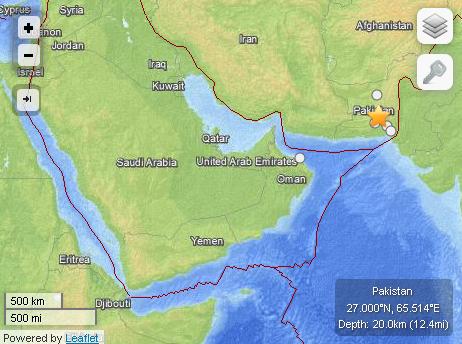
EQ Details
- Event Time: 2013-09-24 11:29:48 UTC
- Location: 27.000°N, 65.514°E
- Depth: 20.0km (12.4mi)
- Nearby Cities
- 66km (41mi) NNE of Awaran, Pakistan
- 116km (72mi) NW of Bela, Pakistan
New Island Emerges from Arabian Sea
The powerful quake caused the seabed to rise and form a small island in the Arabian Sea, about 500 meters off Pakistan’s coastline.
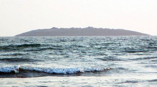
Powerful earthquake hits Baluchistan, forcing the sea bed to rise and form a new island in the Arabian Sea. Image sourced from news.cn/gmw.cn
EQ Location Map
Related Links
Posted in deadly earthquakes, destructive interplate earthquakes, earthquake, Earthquake aftermath, earthquake damage, Earthquake death, Earthquake Hazard, Earthquake news | Tagged: Arabia plate, Arabian Sea, Awaran, Awaran quake, Baluchistan province, earthquake 2013, Earthquake location map, Eurasia plate, India plate, Karachi, Makran subduction zone, Pakistan Earthquake, pakistan quake | Leave a Comment »
Posted by feww on September 24, 2013
M7.7 earthquake strikes 66km NNE of Awaran, Pakistan
A powerful quake measuring 7.7Mw struck 66km north-northeast of Awaran, a remote part of the Baluchistan province in southwestern Pakistan, USGS/EHP reported.
The quake, centered 27.000°N, 65.514°E, struck at a depth of about 20km. Tremors were felt as far east as the Indian capital New Delhi, as well Karachi in Pakistan.
The quake has left at least 100 people dead or injured, and destroyed scores of mud houses in Awaran, according to early reports.
Aftershocks
At least 5 significant aftershocks followed the mainshock, as of posting, with the strongest measuring 5.9Mw.
EQ Location Map [USGS/EHP]

EQ Details
- Event Time: 2013-09-24 11:29:48 UTC
- Location: 27.000°N, 65.514°E
- Depth: 20.0km (12.4mi)
- Nearby Cities
- 66km (41mi) NNE of Awaran, Pakistan
- 116km (72mi) NW of Bela, Pakistan
Estimated Fatalities: Red Alert
USGS has issued a Red Alert Level for shaking-related fatalities, which means high casualties are probable and the disaster is likely widespread. Past events with this alert level have required a national or international level response.
Estimated Economic Losses
USGS has issued an Orange Alert Level for economic losses. Significant damage is likely. Estimated economic losses are less than 1% of GDP of Pakistan.
Tectonic Summary [USGS]
The September 24, 2013 M7.7 earthquake in south-central Pakistan occurred as the result of oblique-strike-slip type motion at shallow crustal depths. The location and mechanism of the earthquake are consistent with rupture within the Eurasia plate above the Makran subduction zone. The event occurred within the transition zone between northward subduction of the Arabia plate beneath the Eurasia plate and northward collision of the India plate with the Eurasia plate. The epicenter of the event is 69km north of Awaran, Pakistan, and 270km north of Karachi, Pakistan (population 11.6 million). Read More…
Posted in earthquake damage, Earthquake death, Earthquake Hazard, Earthquake news, earthquake report | Tagged: Arabia plate, Awaran, Awaran quake, Baluchistan province, earthquake 2013, EQ Location Map, Eurasia plate, Makran subduction zone, Pakistan Earthquake | Leave a Comment »
Posted by feww on July 30, 2010
5.7Mw quake jolts Iran’s NE city of Torbat-e Heydarieh, injuring at least 100 people, trapping dozens more under rubble
“There were no immediate reports of any mortalities in earthquake. However, it is widely believed that a large number of people are trapped under the rubble, and the casualties are expected to be high,” an official said, Press TV reported.
10-degree Map Centered at 35°N,60°E

Earthquake Location Map. Source: USGS/EHP. Enhanced by FEWW.
The earthquake occurred at about 06:20 p.m. local time (13:50UTC) shaking the the city (population: 400,000) for about 10 seconds, “causing excessive telecom disconnections, IRNA reported.”
Building in the rural areas near the epicenter sustained 50 to 80 percent damage, the local governor told news agencies.
The Iranian Seismology Center said the quake struck about 7 km (4.3 miles) outside the city at a depth of about 7 km .
A magnitude-4.9 quake struck the southern Iranian port city of Bandar Abbas, injuring more than 700 people, the report said.
“In 2008, a strong earthquake measuring 6.1 in magnitude struck in Hormozgan, demolishing nearly 200 villages and killing at least six people,” a report said.
In 2003 a 6.7Mw quake struck near the city of Bam in Iran’s Kerman province killing about 25,000 people.
Earthquake Details:
- Magnitude: 5.6 [USGS/EHP estimate]
- Date-Time:
- Friday, July 30, 2010 at 13:50:14 UTC
- Friday, July 30, 2010 at 05:20:14 PM at epicenter
- Location: 35.225°N, 59.271°E
- Depth: 26.1 km (16.2 miles) — [7km- see text]
- Region: NORTHEASTERN IRAN
- Distances:
- 7km (4.3miles) Torbat-e Heydariyeh, Iran
- 115 km (75 miles) SSE of Neyshabur, Iran
- 125 km (75 miles) SSW of Mashhad, Iran
- 715 km (445 miles) E of TEHRAN, Iran
- Location Uncertainty: horizontal +/- 3.7 km (2.3 miles);
- Source: USGS NEIC (WDCS-D)
- Event ID: us2010zibd
Fire-Earth Quake Forecasts and previous events:
Recent significant quakes:
Region: Off East Coast of Kamchatka
Time: 2010-07-30 03:56:13.2 UTC
Magnitude: 6.5
Epicenter: 160.08°E, 52.41°N
Depth: 14 km
Source: GFZ Potsdam – Earthquake Bulletin
Related Links:
More Links:
Posted in earthquake 2010, earthquake damage, earthquake forecast, earthquake report, Earthquakes | Tagged: Iran Earthquake, Torbat-e Heydarieh quake | Leave a Comment »
Posted by feww on January 4, 2010
Two Powerful Quakes Strike Solomon Islands SSE of Gizo
A powerful earthquake Measuring up to 7.5Mw struck 105 km (65 miles) SSE of Gizo, New Georgia Islands, Solomon Isl. at a depth of about 45 km on January 3 at about 22:37 UTC. A strong foreshock measuring up to M6.8, preceded the Mainshock about an hour earlier.
As of posting, at least one aftershock measuring up to 5.4 Mw was reported.
10-degree Map Centered at 10°S,155°E

Earthquake location Map. Source: USGS/EHP. Enhanced by FEWW.
Earthquake Details (mainshock)
- Magnitude: [Maximum EQ magnitude estimated at 7.5 Mw by FireEarth]
- Date-Time:
- Sunday, January 03, 2010 at 22:36:30 UTC
- Monday, January 04, 2010 at 09:36:30 AM at epicenter
- Location 8.912°S, 157.307°E
- Depth 30.5 km (19.0 miles)
- Region SOLOMON ISLANDS
- Distances:
- 105 km (65 miles) SSE of Gizo, New Georgia Islands, Solomon Isl.
- 210 km (130 miles) WSW of Dadali, Santa Isabel, Solomon Islands
- 295 km (185 miles) WNW of HONIARA, Guadalcanal, Solomon Islands
- 2100 km (1310 miles) NNE of BRISBANE, Queensland, Australia
- Location Uncertainty: horizontal +/- 8.5 km (5.3 miles); depth +/- 3.6 km (2.2 miles)
- Source: USGS NEIC (WDCS-D)
- Event ID:us2010rabw
Earthquake Details (foreshock)
- Magnitude 6.5 [Maximum EQ magnitude estimated at 6.8 Mw by FireEarth]
- Date-Time:
- Sunday, January 03, 2010 at 21:48:06 UTC
- Location: 8.880°S, 157.325°E
- Depth 10 km (6.2 miles)
- Distances
- 90 km (55 miles) SSE of Gizo, New Georgia Islands, Solomon Isl.
- 215 km (135 miles) WSW of Dadali, Santa Isabel, Solomon Islands
- 310 km (190 miles) WNW of HONIARA, Guadalcanal, Solomon Islands
- 2115 km (1310 miles) NNE of BRISBANE, Queensland, Australia
- Location Uncertainty: horizontal +/- 10.1 km (6.3 miles)
- Source: USGS NEIC (WDCS-D)
- Event ID: us2010rabr
Historic Seismicity

Tsunami Warning
The Pacific Tsunami Warning Centre in Hawaii earlier said the earthquakes generated a 6cm (NON-Destructve) tsunami.
“[The tsunami] may have been destructive along the coasts near the earthquake epicentre.” It said.
NOAA/NWS/West Coast and Alaska Tsunami Warning Center said a tsunami was NOT expected along the California, Oregon, Washington, British Columbia, or Alaska coast. However, local tsunamis may occur from underwater landslides at coastal locations which have experienced strong ground shaking.
An 8.1Mw quake struck about 60km NW of this earthquake on April 1, 2007, triggering a tsunami near Solomon Islands which crashed into the town of Gizo the capital of the Solomon Islands Western Province (population 6,500), killing 52 people (official death toll) and destroying almost the entire town. More than 5,400 people were left homeless.
In Tajikistan meanwhile…
News agencies reported that a 5.5Mw earthquake which struck Tajikistan on Saturday had destroyed more than 1,000 houses. There were no reports of human casualties as of posting.
Related Links:
Posted in earthquake, earthquake 2010, earthquake damage, earthquake forecast, earthquake report | Tagged: 2007 tsunami, Gizo, Solomon Islands, Tajikistan earthquake, Tsunami Warning update | 2 Comments »
Posted by feww on December 21, 2008
Magnitude 6.5 Earthquake Strikes Off the Coast of Honshu, Japan
The Mainshock was followed by a cluster of at least 5 moderate to strong aftershocks magnitude 4.8 to 5.3.
Update: A magnitude 6.0 aftershock struck near location of mainshock [36.592°N, 142.269°E,] on December 21, 2008 at 09:16:44 UTC.
10-degree Map Centered at 35°N,140°E

Source: USGS
Earthquake Details
Magnitude: 6.5
Date-Time: Saturday, December 20, 2008 at 10:29:22 UTC
Location: 36.603°N, 142.356°E
Depth: 10 km (6.2 miles) set by location program
Region: OFF THE EAST COAST OF HONSHU, JAPAN
Distances:
- 140 km (85 miles) ESE of Iwaki, Honshu, Japan
- 170 km (105 miles) E of Mito, Honshu, Japan
- 210 km (130 miles) SE of Fukushima, Honshu, Japan
- 255 km (160 miles) ENE of TOKYO, Japan
Location Uncertainty: horizontal +/- 8.7 km (5.4 miles); depth fixed by location program
Sourc: USGS NEIC (WDCS-D)
Event ID: us2008avan
Seismicity in 2008

Related Links:
Posted in Earthquake cluster, earthquake damage, Japan shake, Mito, tectonic plates | Tagged: ENE of TOKYO, Fukushima, Honshu earthquake, Iwaki, Japan quake | Leave a Comment »
Posted by feww on December 18, 2008
Earthquake Forecast 2009 – country in focus: Japan

2009 Earthquake Forecast by FEWW / CASF – Release Date: December 18, 2008. [All data are subject to updates and changes.]
Historic Japan earthquakes: 2008 [as of December 18, 2008]
See Also:
[Earthquakes of magnitude 6.5 or greater or ones that caused fatalities, injuries or substantial damage. Source: Data Compiled by Pamela J. Benfield and NEIC Operations Staff.]
Historic japan earthquake: 2007

Earthquake Density Map of Japan [USGS]

Seismicity Map

Credit: USGS
Seismic Hazard Map of Japan

Credit: USGS
Notable Earthquakes in Japan [USGS]
- 1891 10 27 – Mino-Owari, Japan – M 8.0 Fatalities 7,273
- 1896 06 15 – Sanriku, Japan – M 8.5 Fatalities 27,000
- 1923 09 01 – Kanto (Kwanto), Japan – M 7.9 Fatalities 143,000
- 1927 03 07 – Tango, Japan – M 7.6 Fatalities 3,020
- 1933 03 02 – Sanriku, Japan – M 8.4 Fatalities 2,990
- 1943 09 10 – Tottori, Japan – M 7.4 Fatalities 1,190
- 1944 12 07 – Tonankai, Japan – M 8.1 Fatalities 998
- 1945 01 12 – Mikawa, Japan – M 7.1 Fatalities 1,961
- 1946 12 20 – Nankaido, Japan – M 8.1 Fatalities 1,330
- 1948 06 28 – Fukui, Japan – M 7.3 Fatalities 3,769
- 1964 06 16 – Niigata, Japan – M 7.5 Fatalities 26
- 1995 01 16 – Kobe, Japan – M 6.9 Fatalities 5,502
- 2000 10 06 – Western Honshu, Japan – M 6.7
- 2003 05 26 – Near the East Coast of Honshu, Japan – M 7.0
- 2003 09 25 – Hokkaido, Japan Region – M 8.3
- 2003 10 08 – Hokkaido, Japan Region – M 6.7
- 2003 10 31 – Off the East Coast of Honshu, Japan – M 7.0
- 2004 05 29 – Off the East Coast of Honshu, Japan – M 6.5
- 2004 09 05 – Near the South Coast of Western Honshu, Japan – M 7.2
- 2004 09 05 – Near the South Coast of Honshu, Japan – M 7.4
- 2004 09 06 – Near the South Coast of Honshu, Japan – M 6.6
- 2004 10 23 – Near the West Coast of Honshu, Japan – M 6.6 Fatalities 40
- 2004 11 28 – Hokkaido, Japan Region – M 7.0
- 2004 12 06 – Hokkaido, Japan Region – M 6.8
- 2005 03 20 – Kyushu, Japan – M 6.6 Fatalities 1
- 2005 07 23 – Near the South Coast of Honshu, Japan – M 5.9
- 2005 08 16 – Near the East Coast of Honshu, Japan – M 7.2
- 2005 10 19 – Near the East Coast of Honshu, Japan – M 6.3
- 2005 11 14 – Off the East Coast of Honshu, Japan – M 7.0
- 2005 12 02 – Near the East Coast of Honshu, Japan – M 6.5
- 2006 06 11 – Kyushu, Japan – M 6.3
- 2007 03 25 – Near the West Coast of Honshu,Japan – M 6.7 Fatalities 1
- 2007 07 16 – Near the west coast of Honshu, Japan – M 6.6 Fatalities 9
- 2008 05 07 – Near the East Coast of Honshu, Japan – M 6.8
- 2008 06 13 – Eastern Honshu, Japan – M 6.9 Fatalities 13
- 2008 07 23 – Eastern Honshu, Japan – M 6.8 Fatalities 1
- 2008 09 11 – Hokkaido, Japan region – M 6.8

Source: USGS


Source: USGS
Related Links:
Posted in earthquake damage, Earthquake death, Honshu quakes, Japan quakes, population exposure, Significant Earthquakes | Tagged: Earthquake Forecast 2009, Earthquake prediction, Historic earthquakes, Notable Earthquakes in Japan, Seismic Hazard | 5 Comments »
Posted by feww on December 9, 2008
Fire at Tokyo Electric Power Co nuclear complex sickens worker
A fire broke out at the Kashiwazaki-Kariwa nuclear complex owned by Tokyo Electric Power Co, a spokesman said.
A worker was sickened from inhaling smoke, but there was no radiation leak from the incident, the company said.
The nuclear power complex, which was put out of action caused by extensive damage in a 2007 earthquake is reportedly undergoing repairs and quake resistance enhancement (!)
The incident occurred within two days of a full week’s inspection by a team of 10 experts from the United Nations nuclear watchdog, International Atomic Energy Agency, that was assessing earthquakes safety measures.
Related Links:
Posted in earthquake damage, IAEA, Japan, quake resistance, Tokyo | Tagged: fire, Kashiwazaki-Kariwa, radiation leak, TEPCO nuclear plant, Tokyo Electric Power Co | 1 Comment »

