- CJ
- IGE
- OCT
- TML
- TWM
FIRE-EARTH Presentation: Humans Must Be Stopped From Killing Life On Earth
Prepared and presented by FIRE-EARTH Science and affiliated scientists.
- Details are available via FIRE-EARTH PULSARS.
.
.
.
.
.
.

| Sci-rep on 2. Bulletin Board | |
| Jill R on Haiti Earthquake Disaster | |
| JN on FIRE-EARTH Broadcasts Availabl… | |
| CB on Earth Dwellers Incapable of Ev… | |
| Caroline W. on Earth Dwellers Incapable of Ev… | |
| thabiso on 10 million pieces of trash plu… | |
| DT on Earth Dwellers Incapable of Ev… | |
| JC on 2. Bulletin Board | |
| edmundironside on 2. Bulletin Board | |
| feww on FIRE-EARTH Broadcasts Availabl… | |
| thisislindablog on FIRE-EARTH Broadcasts Availabl… | |
| CD on 2. Bulletin Board | |
| DM on Earthquakes | |
| CMC on 2. Bulletin Board | |
| Val on 2. Bulletin Board |
Posted by feww on June 10, 2018
Prepared and presented by FIRE-EARTH Science and affiliated scientists.
.
.
.
.
.
.
Posted in News Alert | Tagged: Earth, life on earth, mass extinction, plague, pollution, War on Plastics | Leave a Comment »
Posted by feww on April 22, 2016
Massive numbers of dead fish including rare species that live in the deep and other marine species have been founds on beaches of Vietnam’s central provinces of Ha Tinh, Quang Tri, Quang Binh and Hue, said reports.
State news outlet Thanh Nien quoted worried locals saying they dared not eat any of the washed up fish, adding in their report that “all signs (are) pointing to an environmental disaster.”
Central Ha Tinh province is home to a sprawling economic zone which houses numerous industrial plants, including a multi-billion dollar steel plant run by Taiwanese conglomerate Formosa.
In 2015, Vietnam earned USD6.6 billion from seafood exports, said the report.
Posted in News Alert | Tagged: environmental disaster, Mass Fish Deaths, pollution, seafood, Steel Plant, Vietnam | 2 Comments »
Posted by feww on March 8, 2014
About 96 Chinese cities monitored for pollution in 2013 failed to meet environmental standards, said Wu Xiaoqing, China’s vice-minister of environmental protection.
Of the 74 cities monitored by Beijing, 71 had various degrees of problems, said Wu at a news conference on Saturday, Reuters reported.
The only three cities that met the standard were the flood-prone city of Haikou in the island province of Hainan, Llasa, the capital of quake-prone Tibet, and the coastal resort city of Zhoushan.
China’s pollution problems can only be solved through fundamental changes to the way the country develops its economy, said Wu.
“When we were chasing GDP growth, we were also paying the price of pollution, and this price is heavy, is massive.”
“China will cut outdated steel production capacity by a total of 27 million tonnes this year, slash cement production by 42 million tonnes and also shut down 50,000 small coal-fired furnaces across the country, according to the government work report delivered by Premier Li on Wednesday,” said Xinhua.
Meanwhile, the Beijing AQI for PM2.5 hit 255 (Very Unhealthy) on Saturday, before falling slightly to 249, as of posting. [Temp: 4°C; range -3°C to 12°C]
For earlier posts on Beijing AQI, search blog content.
Posted in environment, Global Disaster watch, global disasters, significant events | Tagged: air poisoning, AQI, Beijing, China, Chinese Cities, ENVIRONMENTAL HOLOCAUST, PM2.5, pollution, smog | 1 Comment »
Posted by feww on August 29, 2013
Researchers from MIT’s Laboratory for Aviation and the Environment have tracked ground-level emissions from multiple sources including vehicle tailpipes, industrial smokestacks, marine and rail operations, and commercial and residential heating throughout the United States, and found that the pollution causes about 200,000 early deaths each year.
Highlights from the report
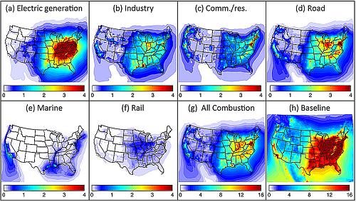 This graphic shows the annual average concentrations of fine particulates from U.S. sources of combustion emissions from (a) electric power generation; (b) industry; (c) commercial and residential sources; (d) road transportation; (e) marine transportation; (f) rail transportation; (g) sum of all combustion sources; (h) all sources. Graphic: Laboratory for Aviation and the Environment/MIT
“In the past five to 10 years, the evidence linking air-pollution exposure to risk of early death has really solidified and gained scientific and political traction,” says Steven Barrett, an assistant professor of aeronautics and astronautics at MIT. “There’s a realization that air pollution is a major problem in any city, and there’s a desire to do something about it.”
The researchers have published their results in the journal Atmospheric Environment.
Posted in air poisoning, disaster watch, disaster watch 2013, disasters, Global Disaster watch, global disasters | Tagged: air pollution, emissions, emissions-related mortality rate, environment, health, industrail emissions, Industry, PM10, PM2.5 map, PM2.5 particulates, pollution, Weather modeling | 4 Comments »
Posted by feww on March 23, 2013
The post is reproduced below with the permission of our CASF and EDRO:
Posted by edro on July 19, 2008 – Submitted by a CASF Member
Climate Change
– Persistent Droughts
– Disruption in climatic patterns
– Low Precipitation
– Higher than normal temperatures
– Heatwaves
– Wildfires and other natural phenomena [disasters] exacerbated by warming
Land
– Urbanization
– Land use and land cover change
– Loss of topsoil
– Soil degradation, especially salination
– Soil erosion caused by high temperatures, low precipitation and hot dry winds
Water
– Extreme water shortages throughout the island worsened by additional [including unforeseen] factors
Tourism
– Causing additional environmental stress
– Creating excessive waste and pollution
– Weakening the Island’s natural defense mechanisms
– Reduced ability to produce food
– Crop failure
– Continued water scarcity (compounded by economic/monetary issues)
– Breakdown of sewage, water and sanitation systems
– Spread of disease pandemics
– Overshoot of Carrying Capacity: The Island may have already passed the tipping point
– Resumption of the Cypriot civil war between the north and south enclaves reignited by the specter of ecological collapse
– Collapse of local ecosystems
– Desertification
– Land abandonment
– Population displacement/climate refugees
2011- 2013
Estimated Population: 793,000 (July 2008 Estimate)
Area:
Total: 9,250 sq km (of which 3,355 sq km are in north Cyprus)
Land: 9,240 sq km
Water: 10 sq km
No. of Tourists: About 3,000,000
Land use:
Arable land: 10.81%
Permanent crops: 4.32%
Other: 84.87% (2005)
Irrigated land: 400 sq km (2003)
Total renewable water resources: 0.4 cu km (2005)
Freshwater withdrawal (domestic/industrial/agricultural):
Total: 0.21 cu km/yr (27%/1%/71%)
Per capita: 250 cu m/yr (2000)
Primary Energy Consumption year 2007: 0.13 Quad BTU [CASF estimate based on EIA data]
Percentage rise compared to year 2000: 20.8 percent
Fossil Fuel consumption (excluding aviation fuel) year 2007: 2,431,399 tonnes of oil [source]
Percentage rise compared to year 2000: 18.4 percent
CO2 Emissions From Consumption of Fossil Fuels year 2007 : 9.65 MMT [CASF estimate for 2007]
Percentage rise compared to year 2000: 22.5 percent
Natural hazards: moderate earthquake activity; droughts
Environment – current issues:
water resource problems (no natural reservoir catchments, seasonal disparity in rainfall, sea water intrusion to island’s largest aquifer, increased salination in the north); water pollution from sewage and industrial wastes; coastal degradation; loss of wildlife habitats from urbanization.
Human Rights Issues
Cyprus [like New Zealand] is primarily a destination country for a large number of women trafficked from Eastern and Central Europe, the Philippines, and the Dominican Republic for the purpose of sexual exploitation; traffickers continued to fraudulently recruit victims for work as dancers in cabarets and nightclubs on short-term “artiste” visas, for work in pubs and bars on employment visas, or for illegal work on tourist or student visas. (Source CIA Factbook, Wikipedia, others)
Population density: It is estimated that at peak tourist season, the effective population density of [Southern] Cyprus exceeds that of the Netherlands (ranked world’s 25th most densely populated).
![]()
Location map: Cyprus (dark green) / European Union (light green) / Europe (dark grey). Credit: User 3meandEr, via Wikimedia Commons
“Extremely hot and dry weather conditions in Cyprus, combined with strong winds led to a disastrous upsurge of forest fires and wildfires in the Troodos Montain area on 29 June 2007. … Small villages had to be evacuated. Some houses were destroyed. Cyprus reported severe material damages in the area. Moreover, two forest fires hit Cyprus on 16 July 2007 in touristic areas of the Island. The first hit the vicinity of the Kalavasos village area … The other was close to Kornos village, which is located 20 km south of Nicosia [capital city]. The total burnt area … in Cyprus measured from satellite imagery on 31 July 2007 was 12 286 hectares.” European Civil Protection.
Climate change is pointing at us “like a loaded gun,” warned the EU Agriculture Commissioner Mariann Fischer Boel at a conference on water policy last week.
“Global warming is happening,” she said. “It’s taken thousands of years for global temperatures to rise by just one degree. In this century we expect to see an increase in global temperatures of between two and six degrees Celsius.”
“Climate change has arrived. Drought has arrived. We need to take out insurance now. Good business sense demands better use of water. For those farmers caught unprepared, climate change could be a sledge hammer,” said Boel. “Maybe there are areas that will benefit from this, like in the north, but we expect climate change to leave a wave of destruction. We expect more heat waves, drought, floods and crop failures.”
“We are going through a visual process of desertification. Krasochorio near Limassol, has lost its environment [Ecosystems have collapsed]. Around 85 per cent of the population has left. In Lania, 30 villas are surrounded by burnt land after the fires. What can the villagers do with them now?” Said the former Cypriot Agriculture Ministry official, Antonis Constantinou.
“What Cyprus is not good at is holding water, avoiding erosion, adapting to water shortage, and not giving incentives which can’t guarantee a better future for the island. We are also not so good at keeping greenery, avoiding fires, fighting fires, giving incentives to people to manage land, even non-agricultural land owners,” he added. (Source)
Recent History
Cyprus is situated in the eastern Mediterranean south of Turkey, north of Egypt, and east-southeast of Greece, It is the third-largest Mediterranean island and a busy tourist destination, attracting about 3 million tourists each year.
A former British colony, it gained independence from the UK in 1960 claiming sovereignty over 97% of the island and surrounding waters, with the United Kingdom controlling the remaining three percent. It became a member of the European Union May 1, 2004.
In 1974, following a period of violence between Greek Cypriots and Turkish Cypriots and an attempted Greek Cypriot coup d’état aimed at annexing the island to Greece and sponsored by the Greek military junta of 1967-1974, Turkey invaded and occupied one-third of the island. This led to the displacement of thousands of Cypriots and the establishment of a separate Turkish Cypriot political entity in the north. Cyprus is thus divided to:

Map of Cyprus: WSBA and ESBA (British military bases at Akrotiri and Dhekelia) are in pink, UN buffer zone dividing the northern (Turkish) and southern (Greek) administrations is shown in gray. The map is adapted from the CIA World Factbook map. (Source).
Related Links:
edro
Posted in Global Disaster watch, global disasters, global disasters 2013 | Tagged: Climate Change, Cyprus, Cyprus Collapse, Cyprus Collapse Timeline, Drought, ecosystems collapse, health, IMPACT OF TOURISM, Mediterranean, politics, pollution, soil erosion, topsoil, Tourism, Travel, war, water rationing | Leave a Comment »
Posted by feww on August 10, 2008
Original Entry:
Posted in Climate Change, energy, environment, food, Global Warming, health, new zealand, politics, Tourism, Travel | Tagged: body bags, Dead Tourists Society, death compensation, health, Iraqi war zone, Murder, pollution, Sarah Katie Bond, Tourism, Tourist Deathtrap, Travel, UK, UK tourist | Leave a Comment »
Posted by feww on July 25, 2008
Of nearly 90,000 chemical compounds in use, the majority of which have never been tested for health effects, only a fraction are registered and of those only a handful have been banned by EPA in the last thirty years. Meanwhile, about 2,000 new chemicals are introduced each year.
Related Links:
.
Posted in air pollution, BMW, environment, food, germany, health, Munich, politics | Tagged: arsenic, asbestos, Bisphenol A, EPA, EU, flame-retardants, immune system, Maine, mercury, neurological system, pesticides, PFC, phthalates, pollution, REACH, reproductive system, toxic chemicals., toxic pollution, water repellents | 1 Comment »
Posted by feww on July 15, 2008
The Island of Hawaiʻi (the Big Island or Hawaiʻi Island) is a volcanic island With an area of 4,028 square miles (10,432 km²), it is the largest island in the United States and larger than all of the other Hawaiian Islands combined.
The Island of Hawaiʻi is built from five separate shield volcanoes that erupted somewhat sequentially, one overlapping the other. These are (from oldest to youngest):

This simulated true-color image of the island of Hawai’i was derived from data gathered by the Enhanced Thematic Mapper plus (ETM+) on the Landsat 7 satellite between 1999 and 2001. Image: NASA/NOAA
The Island of Hawaiʻi is administered under the County of Hawaiʻi. The county seat is Hilo. It is estimated that as of the year 2003, the island had a resident population of 158,400.
MAP of Principal Islands of Hawaii

Source: [http://www.lib.utexas.edu/maps/united_states Perry-Castañeda Library Map Collection]
In greatest dimension, the island is 93 miles (150 km) across and has a land area of 4,028.0 square miles (10,432.5 km²),representing 62% of the total land area of the Hawaiian Islands. Measured from its base at the sea floor, to its highest peak, Mauna Kea is the tallest mountain in the world, even taller than Mount Everest, according to the Guinness Book of Records. Traditionally, Hawaiʻi is known as the Big Island because it is the largest of the Hawaiian Islands and some confusion between Hawaiʻi Island and Hawaiʻi State can be avoided.

Mauna Kea with its seasonal snowcap, viewed from Kohala Mountain . Mauna Kea is a dormant volcano in the Hawaiian Islands, one of five volcanoes which together form the island of Hawaii. Pu’u Wekiu, one of numerous cinder cones on the summit plateau, is the highest point in the state of Hawaii at 13,796 feet (4,205 m). Mauna Kea is the tallest mountain in the world when measured from base to summit, since its base is located on the seafloor about 19,000 feet (5,800 m) beneath the surface of the Pacific Ocean, bringing its total height to about 33,000 ft (10,000 m). In the Hawaiian language, mauna kea means “white mountain”, a reference to its summit being regularly snow-capped during the Northern Hemisphere winter. [Caption from Wikipedia]
Licensed under the terms of the GNU Free Documentation license, Version 1.2 or any later version published by the Free Software Foundation. Credit: Eric Guinther; via Wikimedia Commons
Because Mauna Loa and Kīlauea are active volcanoes, the island of Hawaiʻi is still growing. Between January 1983 and September 2002, 543 acres (220 ha) of land were added to the island by lava flows from Kīlauea volcano extending the coastline seaward. Several towns have been destroyed by Kīlauea lava flows in modern times: Kapoho (1960), Kalapana (1990), and Kaimū (1990). (Source: Wikipedia)


Related Links:
Posted in air soil and water pollution, Climate Change, energy, environment, food, Global Warming, health, raw sewage, Tourism, Travel | Tagged: Hawaiʻi Volcanoes National Park, Hawaii, Kīlauea, Mauna Loa, pollution | Leave a Comment »
Posted by feww on July 12, 2008
What People Said:

A firefighter with the Lathrop-Manteca Fire District talks on his radio as a spot fire burns through trees and brush July 10, 2008 in Concow, California. (Justin Sullivan/Getty Images) Image may be subject to copyright. See FEWW Fair Use Notice!

A mountain bike is one of the few items recognizable at a home in the Camelot subdivision in Concow, Calif. Chronicle photo by Paul Chinn. Image may be subject to copyright. See FEWW Fair Use Notice!

This image of the combined fires was captured by the Moderate Resolution Imaging Spectroradiometer (MODIS) on NASA’s Terra satellite on July 10, 2008.
Numerous major wildfires continued burning Friday in Eastern Washington, prompting Gov. Chris Gregoire to declare a state of emergency for the entire state. That freed equipment, firefighters and funding for efforts to quench the flames.
Fire crews from across Washington were battling blazes in Chelan, Douglas, Stevens, Adams, Ferry, and Spokane counties. With hot and dry conditions statewide, Gregoire said the proclamation ensured any affected area would have sufficient firefighting resources. (Source)
Related News Links:
Related Links:
Posted in Climate Change, environment, food, health, politics | Tagged: air pollution, air quality, Basin Complex fire, Butte Lightning Complex, California Wildfires, CARMEL FIRE, Climate Change, energy, forest fires, Gap Fire, Global Warming, Goleta, life or lifestyle?, life policy, Los Padres, Paradise, pollution, Sacramento, Santa Barbara, Schwarzenegger, Spokane Valley, Tourism, Washington | 3 Comments »
Posted by feww on July 10, 2008
submitted by a member
A firefighter watches over a backfire set in a redwood forest along Pacific Coast Highway 1 during a massive wildfire in Big Sur, California July 6, 2008. REUTERS/ Robert Galbraith. Image may be subject to copyright. See FEWW Fair Use Notice!
Up to 15,000 residents of Paradise, California, were ordered to leave their homes on Wednesday as fire threatened to spread into town where it consumed nearly 80 homes in June.
The ‘Butte Lightning Complex’ fire near Paradise, about 140 km north of Sacramento, is one of nearly 350 lightening-started wildfires still burning across California. The Butte fire has consumed about 20,000 hectares since June, destroying as many as 60 structures including 45 residences and now threatens up to 4,000 residences.
In the Big Sur area 2,300 firefighters and volunteers have contained about a quarter of the Basin Complex fire, which has burned up to 40,000 hectares of land along California’s pacific coast. Further south, about a half of the Gap Fire in Goleta, near Santa Barbara, which has consumed about 4,000 hectares, has been contained.
About a quarter of a million hectares of scenic land have been scorched in California in the past two weeks. Meanwhile California temperatures rise in what is considered to be “the first significant heat wave of the summer,” according to the California Independent System Operator.
In October 2007, California Wildfires left eight people dead, burned about 200,000 hectares and consumed 2,000 homes displacing about 700,000 people.
The National Weather Service has issued the following alerts throughout California:
For more information go to: National Weather Service link
Posted in Climate Change, energy, environment, food, Global Warming, health, politics, Tourism | Tagged: air quality, Basin Complex fire, Butte Lightning Complex, California Wildfires, Gap Fire, Goleta, life policy, Los Padres, Paradise, pollution, Sacramento, Santa Barbara, Schwarzenegger | 5 Comments »
Posted by feww on June 25, 2008
See Original Entry:
Posted in Climate Change, energy, environment, food, health, new zealand, politics, Tourism | Tagged: 7-day fever, beef, canefield fever, canicola fever, cattle, cause of death, CDC, deadly infection, deer, developed world, family dog, farmers, Hawke's Bay, health, health warning, Human Leptospirosis Infection, inspectors, kidney transplant, leptospiral infection, Massey University, Meat workers, nanukayami fever, new zealand, New Zealand Poisoning Syndrome, pigs, pollution, sheep, Tourism, tourist, Tourist Deathtrap, Travel, Triathlete, University Campus, veterinarians, Weil's disease. | Leave a Comment »
Posted by feww on June 17, 2008
Health workers revealed an outbreak of group A streptococcus bacterium, which causes rheumatic fever and can lead arthritis and heart damage, had infected at least 32 children in Kaikohe, New Zealand.
Original Entry Blocked by Google:
![]()
Photomicrograph of Streptococcus pyogenes bacteria, 675x Mag. A pus specimen, viewed using Pappenheim’s stain. Last century, infections by S. pyogenes claimed many lives especially since the organism was the most important cause of puerperal fever and scarlet fever. This media comes from the Centers for Disease Control and Prevention’s Public Health Image Library (PHIL), with identification number #2110.
News Links:
Related Links:
Posted in Climate Change, energy, environment, food, Global Warming, health, new zealand, politics, Tourism, Travel | Tagged: breaking news, compound 1080, cyanobacteria, Don’t Take the kids To New Zealand, Emergency Warning, Group A Streptococcus, health, Listeria, Murder, mystery bacterium, new zealand, New Zealand Poisoning Syndrome, news, pollution, Salmonella Mbandaka, Sewage contaminated beaches, Staphylococcus aureus, streptococcus Bacterium, Streptococcus pyogenes bacteria, Tourism, tourist, Tourist Deathtrap, Toxic blue-green algae, Travel, Viral Gastroenteritis | 5 Comments »
Posted by feww on June 16, 2008
Google has effectively blocked the following posts from its search engines:
Freedom of speech is being able to speak freely without censorship. The United States Constitution protects opinions under inalienable 1st Amendment free speech rights.
The right to freedom of speech is also guaranteed under international law through numerous human-rights instruments, notably under Article 19 of the Universal Declaration of Human Rights and Article 10 of the European Convention on Human Rights.
How much longer is Google allowed to continue its censorship in violation of the United States Constitution and the international law?
Posted in 1st Amendment, free speech, Tourism, Tourists | Tagged: China, China quake, Chinese Victim, Europe, free speech rights, freedom of speech, Google, Google censorship, google gag, google law, health, human rights, Murder, new zealand, New Zealand Poisoning Syndrome, Octogenarian Chinese Woman, Plumbing the Depth of Depravity, politics, pollution, racism, Racist Storm, rape, Tourism, Tourist Deathtrap, Travel, United States, United States Constitution | 1 Comment »
Posted by feww on June 14, 2008
submitted by a reader
One minute you are in your comfortable home near Paradise, north of Sacramento, the next minute you are being consoled by the firefighters as you stand in the front garden watching your home turn into blackened cinder. They apologize for failing to help you, but it wasn’t their fault. They ran out of water!

Butte Valley fire, Humboldt, Thursday night. Image: Jason Halley / Chico Enterprise-Record. Image may be subject to copyright. See FEWW Fair Use Notice!
Into the SUV with what little you could snatch away from the mouth of the fire heading east to Iowa to stay with Aunt Molly. On interstate 29 a twister is about to touch down. Whoosh! You swerve out of the way just in time.

Parkersburg Tornado. Photo AP. Image may be subject to copyright. See FEWW Fair Use Notice!
Aunt Molly’s house in Cedar Rapids wasn’t so lucky. It didn’t have wheels to drive away and avoid the floodwater; it is completely deluged.
An aerial photo shows a flooded area of downtown looking North over Cedar Rapids, Iowa June 13, 2008. Interstate I-380 can be seen at top while Mays Island, with Cedar Rapids City Hall, is seen on the left with its bridges under water. Floodwaters have inundated about 100 city blocks of Cedar Rapids, Iowa’s second-largest city with 200,000 residents. REUTERS/Ron Mayland. Photo AP. Image may be subject to copyright. See FEWW Fair Use Notice!
Five hours and a dozen phonecalls later, you are finally heading to the calm of Wisconsin to stay with Cousin Thelma and her family. Turn the radio on. Homes on Lake Delton in central Wisconsin have been ripped apart by deadly storm and washed away by floodwaters. Chilly gooseflesh grow on your forearms. Something tingles deep inside your gut, that uncomfortable feeling something is wrong. And you are right! Well, It’s Friday the 13th, you hear yourself murmuring.

Lake Delton is a popular tourist spot south of the Wisconsin Dells. Image may be subject to copyright. See FEWW Fair Use Notice!
Distant Cousin Joe and his family are in deep mourning in Loveland. Two of their kids with four of their classmates and a teacher didn’t make it back from a fishing trip. And his 5,000 acre cornfield is submerged in floodwater …
Corn crop submerged in floodwaters near Loveland, Iowa, June 12, 2008. REUTERS/Dave Kaup. Image may be subject to copyright. See FEWW Fair Use Notice!
Back to Iowa to stay with an old classmate who lives in Marshal Town, Iowa, and who invited you to visit her last summer. A rain check is as good as … a rain check! Finally you arrive in Marshal Town. But the whole town has been evacuated and the power plants have been shut down!
Well, at least you have the good old, reliable SUV, and it’s not as if the world is running out of corn to make ethanol for you!
Related Links:
feww
Posted in Climate Change, energy, environment, food, Global Warming, health, politics, Travel | Tagged: agriculture, calif., Cedar Rapids, corn, cornfield, Drought, environmental disaster, Environmental Impacts, ethanol, flood, floodwater, GHG, gooseflesh, grains, Iowa, Lake Delton, maize, Mays Island, Paradise, Parkersburg, pollution, Sacramento, socal, SUV, topsoil, Tornado, twister, wildfire, Wisconsin, You ain’t seen nothing yet! | 3 Comments »
Posted by feww on June 9, 2008
According to a Chinese specialist, Luan Weixin, a professor at the Economics and Management College at Dalian Maritime University:
A child clears water from his boat in the algae-filled Chaohu Lake in Hefei, in east China’s Anhui province October 14, 2007. Blue-green algae has caused water pollution in Chaohu Lake, China’s fifth largest fresh water lake, where the rare whitebait production is on the decline, Xinhua News Agency reported. REUTERS/Jianan Yu (CHINA). Image may be subject to copyright. See FEWW Fair Use Notice!
“Over the past 20 years or so, China’s marine economy has been developing at a staggeringly rapid pace and marine resources are being widely tapped. As a result, the condition of China’s inshore environment is deteriorating and the ocean ecology has been seriously damaged,” he said. (Source)
A man carrying lotus roots walk through an algae-filled pond in Yingtan, east China’s Jiangxi province, October 12, 2007. China’s pollution woes will form the smoggy backdrop to a key Communist Party gathering in October as leaders, who long treated nature as a foe to conquer, now fear that dirty air and water threaten stability and growth. REUTERS/Stringer (CHINA) CHINA OUT. Image may be subject to copyright. See FEWW Fair Use Notice!
Related Links:
<>
Posted in Climate Change, energy, environment, food, Global Warming, health, politics, Tourism, Travel | Tagged: acidification, Anhui Province, beijing olympics, blue-green algae, Bohai, Chaohu Lake, chemicals fertilizers, China, coral reefs, Dalian Maritime University, excessive reclamation, Hangzhou, Hefei, Liaoning, Luan Weixin, mangroves, nitrogen, phosphate, pollution, Water pollution, wetlands, Yangtze river, Yellow river, Zhujiang river | Leave a Comment »
Posted by feww on June 7, 2008
Posted in Canada, cancer-causing, carcinogens, cause of death, Chemical hazard, chemical pollution, children, China, Climate Change, collapse, energy, environment, food, Global Warming, health, new zealand, politics, Tourism, Travel | Tagged: biological weapons, bullies, DDT, dioxins, head-banging animals, health, hormone disrupter, Hutt Valley, Israel, Marlborough Girls' College, mind-altering, mind-altering drugs, New Zealand Poisoning Syndrome, pack mentality, PCBs, pollution, rape, top-secret, Tourism, tourist, Tourist Deathtrap, Travel, Waikato | Leave a Comment »
Posted by feww on June 4, 2008
A new disease affecting tomatoes and capsicum have been discovered at three of New Zealand’s North Island hothouses. A new bacterium has been discovered, which is causing severe problems, including leaf curling and yellowing; however, little is known about its origin or potential dangers. (Source)
Related Links:
Posted in breaking news, Climate Change, energy, food, new zealand, politics, Tourism, Travel | Tagged: bacterium, capsicum, child safety, Emergency Health Warnings, food hygiene, health, leaf curling, Murder, mystery bacterium, New Zealand Food Imports, New Zealand Poisoning Syndrome, pollution, rape, Stomach bug, tomato, Tourism, tourist, Tourist Deathtrap, Travel, Urgent Health Warning, yellowing | 4 Comments »
Posted by feww on May 10, 2008
Just when you thought the Antarctic marine life had only a few minor problems like the climate change and ozone hole to worry about, but were otherwise safe from other harms like ingesting plastic trash, or growing a “skin” rash from pesticide contamination, it has been revealed that the deadly pesticide DDT, banned in most countries more than 35 years ago, stills show up in penguins in Antarctica.
A researcher has blamed the DDT contamination on the chemical’s accumulation of the poison in melting glaciers.
“DDT, along with a lot of other of these organic contaminants, actually travel through the atmosphere … toward the polar regions by a process of evaporation and then condensation in cooler climates,” according to Heidi Geisz of the Virginia Institute of Marine Science.
The DDT contamination in the Adelie penguins was first discovered in 1964. The contamination level rose in the 1970s and has stayed stable since then, Geisz said.

Mating Adelie penguins at Cape Adare in Ross Sea, Antarctica January of 2001. This file is licensed under the Creative Commons Attribution ShareAlike license versions 2.5, 2.0, and 1.0 (Credit: Mila Zinkova)
In 1962, Silent Spring by American biologist Rachel Carson was published. The book cataloged the environmental impacts of the indiscriminate spraying of DDT in the US and questioned the logic of releasing large amounts of chemicals into the environment without fully understanding their effects on ecology or human health. The book suggested that DDT and other pesticides may cause cancer and that their agricultural use was a threat to wildlife, particularly birds. Its publication was one of the signature events in the birth of the environmental movement. Silent Spring resulted in a large public outcry that eventually led to most uses of DDT being banned in the US in 1972. DDT was subsequently banned for agricultural use worldwide, but its limited use in disease vector control continues to this day in certain parts of the world and remains controversial. (source)
Is it possible that New Zealand is still using DDT in large quantities?
Related Links:
Posted in Climate Change, environment, health, politics, Tourism, Travel | Tagged: Adelie penguins, Antarctica, atmosphere, biology, cancer, chemicals, contamination, DDT, disease vector control, Heidi Geisz, melting glaciers, new zealand, ocean, organic contaminants, pesticides, pollution, Rachel Carson, Silent Spring, Virginia Institute of Marine Science | Leave a Comment »
Posted by feww on April 10, 2008
A patch of garbage dubbed the Great Pacific Garbage Patch floats in the middle of the Pacific Ocean in North Pacific Gyre. Depending on the source, the size estimate of the patch varies from the size of Texas to twice as large as the continental United States.

The North Pacific Gyre (top, center)is one of five major oceanic gyres. (Image Credit: NOAA)

Marine debris on the Hawaiian coast (Image Credit: NOAA)
Related Links:
An Interesting animation of how the garbage entering the ocean is caught by the gyre.
.
Posted in Bisphenol A, california, Hawaii, infertility, Pacific Ocean, plastic bags, polyethylene, PVC, Water pollution | Tagged: environment, Garbage Island, life, North Pacific Gyre, oceans, plastics, pollution, Texas | 9 Comments »
Posted by edro on October 16, 2007
Accumulation of toxic pollution in the environment is one of the dynamics that is driving the ecosystems to the verge of collapse. In the worst case scenario, which could unfold by as early as 2012¹, about 20% the world’s cities become unsustainable and begin to collapse. Massive waves of human migration from the affected areas create domino effect that causes the collapse of most of the remaining population centers. It may be too late to make a significant difference to the final outcome; however, we still have the option to change the worst case scenario! See Collapsing Cities
1. The date “2012” is based on the dynamic model simulations analyzing the impact of excessive energy consumption on the environment. The CASF Committee and its Members do NOT endorse the Mayan Calendar or any New Age, ancient, or bible prophecies whatever.
The idea of having ‘legal limits’ on how much damage you can inflict on nature must surely be a Freudian design. It’s like imposing the death penalty on the victim; and nature isn’t even ‘legally’ represented!
Freud said: “Against the dreaded external world one can only defend oneself by some kind of turning away from it, if one intends to solve the task by oneself. There is, indeed, another and a better path: that of becoming a member of human community, and, with the help of a technique guided by science, going over to attack against nature and subjecting her to human will. [And if the technique guided by science fail to reverse the ‘marsification’ of Earth that it started in the first place, you can always hide behind more abstractions!]” Excerpt from The Death of Homo Sapiens Sapiens (Part 1)
Defendant: Planet Earth (AKA, Blue Marble)
Age: 4.5 billion years
Color: Blue
Verdict: The Defendant stands convicted of the serious felonies of aiding and abetting humanoids by way of providing them with life and material support including air, water, food, land, atmosphere, ecosystems, energy… and majestic splendor.
Sentence: Death by Lethal Pollution [the sentence shall be carried out in the early morning of the Third Millennium, CE.]
 “Troubled Waters” by U.S. PRIG
San Francisco Chronicle
Zachary Coile, Chronicle Washington Bureau
Friday, October 12, 2007
More than half of all industrial and municipal facilities across the country dumped more sewage and other pollutants into the nation’s waterways than allowed under the Clean Water Act, according to a report released Thursday by an environmental group. Read more…
Download the full report, Troubled Waters, by U.S. PRIG Education Fund. (1.12 MB, PDF)
Related Links:
Posted in death penalty, environmnet, governmnet, politics, pollution | Tagged: pollution, Water pollution | 23 Comments »
