Archive for May, 2016
Posted by feww on May 20, 2016
Fort McMurray wildfire is almost the size of Delaware
The massive forest fire that devastated Fort McMurray, Alta., has now crossed the border into Saskatchewan, said Canadian officials.
The ferocious fire had devoured 505,645 hectares of forest as of Thursday morning local time, and expanded east of the border, burning 771 hectares in Saskatchewan, according to fire officials.
The fire is said to be about 30km from the nearest village, La Loche.
The latest Canadian Wildland Fire Information System map indicates the Fort McMurray fire has entered Saskatchewan at two points. However, the Saskatchewan government insists the southern part is actually a brand new, 40-hectare fire, said a report.
“One of the new fires, which covers 40 hectares, started close to the Fort McMurray fire on the Saskatchewan-Alberta border sometime during the evening on May 18.”
Posted in News Alert | Tagged: Alberta, Delaware, forest fire, Fort McMurray, Saskatchewan, wildfire | Leave a Comment »
Posted by feww on May 20, 2016
HPV, PYM
Volcan de Fuego and Santa Maria Volcano erupt

Santa Maria volcano explodes at Santiaguito Dome Complex, sending a column of ash about 4,500 meters into the air. (Photo Credit: Prensa Libre/Carlos Ventura)
The 3,771-meter high Santa Maria, is a massive active volcano located in the western highlands of Guatemala.
The VEI 6 eruption of Santa Maria in 1902 was the third largest eruption of the 20th century, following the 1912 Novarupta and 1991 Pinatubo eruptions.
Volcano of Fire: The volcano that never sleeps
The ash column from eruption at Volcán de Fuego [the “Volcano of Fire”] reached a height of about 5,500 meters above sea level, with “moderate” lava flow from the summit.

The volcano that never sleeps. A new round of activity began at Volcán de Fuego, exactly four years ago on May 19, 2012. Photo credit: Ana Patricia Orizaba
Posted in News Alert | Tagged: Guatemala, HPV, PYM, Santa María volcano, Santiaguito Dome Complex, volcanism, Volcano eruption, Volcán de Fuego | Leave a Comment »
Posted by feww on May 19, 2016
Extreme Rain Events Trigger Flash Floods and Landslides Affecting 22 of 26 Districts in Sri Lanka
At least 43 people have been killed and about 307,000 people displaced by the deadly floods, according to the government.
“At approximately 4.00 pm on Tuesday evening an entire side of the Siripura mountain collapsed into the valley below after receiving torrential rains for two consecutive days. The landslide buried three villages including Piyasenas,” said a report.
Some 220 families lived in Siripura and the neighboring villages of Pallebage and Elagipitiya; however, only 19 bodies have been retrieved, so far, and hundreds remain missing.
Related Links
Posted in News Alert | Tagged: DEADLY FLOODS, extreme rain event, flash flood, Landslide, Siripura mountain, SRI LANKA | Leave a Comment »
Posted by feww on May 19, 2016
Global Temperature Analysis – April 2016
The combined average temperature over global land and ocean surfaces for April 2016 was 1.10°C (1.98°F) above the 20th century average of 13.7°C (56.7°F)—the highest temperature departure for April since global records began in 1880, according to NOAA.
- Average global temperature across land for April 2016 was 1.93°C (3.47°F) above the 20th century average of 8.1°C (46.5°F).
- Globally averaged SST was 0.80°C (1.44°F) above the 20th century monthly average, making it the highest global SST for April on record.
- Overall, 13 out of the 15 highest monthly temperature departures in the record have all occurred since February 2015, with February 1998 and January 2007 among the 15 highest monthly temperature departures.
Year-to-Date
- Highest global land and SST average temperature for January–April at 1.14°C (2.05°F) above the 20th century average—beating the previous record set in 2015 by 0.30°C (0.54°F).
- Record high average land surface temperature at 2.04°C (3.67°F) above average, surpassing the previous record of 2015 by 0.59°C (1.06°F).
- Highest average SST temperature for the year-to-date at 0.81°C (1.46°F) above average.

April 2016 Selected Climate Anomalies and Events Map
.
Source: NOAA National Centers for Environmental Information, State of the Climate: Global Analysis for April 2016, published online May 2016, retrieved on May 19, 2016 from http://www.ncdc.noaa.gov/sotc/global/201604.
Posted in News Alert | Tagged: April 2016, Global Temperature Analysis, NOAA, Significant Climate Anomalies, State of Climate Report, temperature anomalies | Leave a Comment »
Posted by feww on May 18, 2016
PYM
NOTE: Details of this event are subject to change by USGS/EHP
M6.8 event occurs NW of Rosa Zarate, Ecuador
Centered at 0.465°N, 79.641°W, 24.0 km (14.9 mi) NW of Rosa Zarate, and just north of the Equator, the quake occurred at a depth of 31km (19.3 mi), reported USGS/EHP.
- The event was the second strong shock to rattle NW Ecuador in under 10 hours, today (UTC).
Shallow EQs along Nazca – S. America Plates Subduction Zone
- 1960. M9.5 in S Chile (world’s largest instrumentally recorded earthquake)
- 1906. M8.5 near Esmeraldas, Ecuador
- 1922. M8.5 earthquake near Coquimbo, Chile
- 2001. M8.4 Arequipa, Peru
- 2007. M8.0 earthquake Pisco, Peru
- 2010. M8.8 Maule, Chile (occurred ~ 200km north of the 1960 event)
Related links
FIRE-EARTH Beacons Schedule:
Additional Information will be beamed at 22:02UTC (May 18, 2016) and 00:04UTC (May 19, 2016)
Posted in "QF", News Alert | Tagged: earthquake, ecuador, FIRE-EARTH BEACONS, HPV, Mache-Chindul, Nazca Plate, PYM, Quito | Leave a Comment »
Posted by feww on May 18, 2016
Hundreds of families feared buried by landslides in Sri Lanka, dozens confirmed dead
Extreme rain events have triggered large-scale landslides burying several villages in Kegalle District, about 70 kilometers (45 miles) north of the capital, Colombo.
- At least 200,000 people have lost their homes.
- Up to 60 people were confirmed dead, as of posting.
- Hundreds of families are missing, feared buried by landslides.
- More than a dozen people were killed by lightning strikes.
- At least 19 of the country’s 25 districts have experienced flash flooding.
- Severe flooding reported in several cities including Colombo.
Posted in News Alert | Tagged: Colombo, deadly weather events, Extreme Rain Events, floods, Landslide, SRI LANKA | Leave a Comment »
Posted by feww on May 18, 2016
HPV
M6.7 earthquake occurs WNW of Quito, Ecuador
Centered at 0.428°N, 79.765°W, just north of the Equator, the quake occurred at a depth of depth=32.4 km (20.1 mi), reported USGS/EHP.
EQ Details
Magnitude: 6.7Mw [USGS/EHP]
Location: 0.428°N, 79.765°W depth=32.4 km (20.1 mi)
Time: 2016-05-18 07:57:05 (UTC)
Distances:
- 34.0 km (21.1 mi) WNW of Rosa Zarate
- 35.0 km (21.7 mi) ESE of Muisne
- 56.0 km (34.8 mi) S of Propicia
- 101.0 km (62.8 mi) NW of Santo Domingo de los Colorados
- 156.0 km (96.9 mi) WNW of Quito, Ecuador
Shallow EQs along Nazca – S. America Plates subduction zone
- 1960. M9.5 in S Chile (world’s largest instrumentally recorded earthquake)
- 1906. M8.5 near Esmeraldas, Ecuador
- 1922. M8.5 earthquake near Coquimbo, Chile
- 2001. M8.4 Arequipa, Peru
- 2007. M8.0 earthquake Pisco, Peru
- 2010. M8.8 Maule, Chile (occurred ~ 200km north of the 1960 event)
Posted in News Alert | Tagged: earthquake, ecuador, HPV, Mache-Chindul, Nazca Plate, Quito | 1 Comment »
Posted by feww on May 17, 2016
CJ Members
FIRE-EARTH Beacons fully operational
You can now see the programs without looking, and even with your eyes closed!
- FIRE-EARTH BEACONS began beaming at 00:02UTC today, May 18, 2016.
- FIRE-EARTH Channels are being phased out.
Posted in News Alert | Tagged: CJ Members, Fire-Earth, FIRE-EARTH BEACONS, FIRE-EARTH Program, Speed of Thought | 2 Comments »
Posted by feww on May 16, 2016
CJ Members
Program in progress on FIRE-EARTH Channels…
For details of program and the Q & A session, tune in to your local channels.
- Starting May 16, 2016 at 16:32 UTC
***
IMPORTANT NOTICE – IMPORTANT NOTICE – IMPORTANT NOTICE
- FIRE-EARTH BEACONS will begin beaming at 00:02UTC on May 18, 2016
Posted in News Alert | Tagged: 16 May 2016, 18 May 2016, CJ Members, Fire-Earth Alert, FIRE-EARTH BEACONS, FIRE-EARTH Science Team, Important Notice, Program in Progress, Q & A | Leave a Comment »
Posted by feww on May 15, 2016
CJ Members
Program in progress on FIRE-EARTH Channels…
For details of program and the Q & A session, tune in to your local channels.
- Starting May 15, 2016 at 16:03 UTC
***
IMPORTANT NOTICE – IMPORTANT NOTICE – IMPORTANT NOTICE
- FIRE-EARTH BEACONS will begin beaming at 00:02UTC on May 18, 2016
Posted in News Alert | Tagged: CJ Members, Fire-Earth Alert, FIRE-EARTH BEACONS, FIRE-EARTH Channels, FIRE-EARTH Science Team, Important Notice, Q & A | Leave a Comment »
Posted by feww on May 14, 2016
CJ Members
Program in progress on FIRE-EARTH Channels…
For details of program and the Q & A session, tune in to your local channels.
- Starting may 14, 2016 at 19:05 UTC
***
IMPORTANT NOTICE – IMPORTANT NOTICE – IMPORTANT NOTICE
- FIRE-EARTH BEACONS will begin beaming at 00:02UTC on May 18, 2016
Posted in News Alert | Tagged: BEACONS, CJ Members, evacuation alert, Fire-Earth Alert, FIRE-EARTH Channels, FIRE-EARTH Science Team, Important Notice, Q & A | Leave a Comment »
Posted by feww on May 13, 2016
GMR
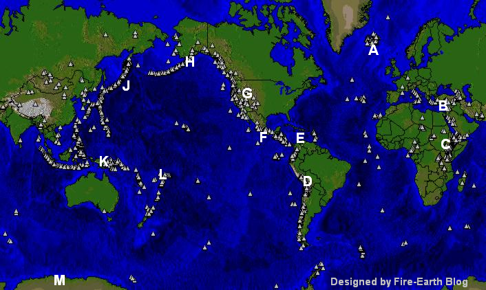
Tempo Rising: 28 Volcanoes Firing
[Watch how the Internet prophets and plagiarizers misinterpret this! ]
Latest Volcanic Activity
- Turrialba (Costa Rica)
- Rincón de la Vieja (Costa Rica)
- Guanacaste volcano (Costa Rica)
- Bristol Island (South Sandwich Islands -UK) NOM
- Nevados de Chillán (Chile)
- Ruapehu, (North Island, NZ)
- White Island, (North Island, NZ)

Map of Volcanoes. Background Map: University of Michigan. Designed and enhanced by Fire Earth Blog. Click image to enlarge.
Ongoing Activity
- Aira (Kyushu, Japan)
- Alaid (Kuril Islands, Russia)
- Bagana (Bougainville, PNG)
- Chirpoi (Kuril Islands, Russia)
- Cleveland (Chuginadak Island, Alaska)
- Colima (Mexico)
- Dukono Halmahera (Indonesia)
- Fuego (Guatemala)
- Kerinci (Indonesia)
- Karymsky (E. Kamchatka, Russia)
- Kerinci (Indonesia)
- Kilauea (Hawaii)
- Klyuchevskoy (C. Kamchatka, Russia)
- Langila (New Britain, PNG)
- Masaya (Nicaragua)
- Nevado del Ruiz (Colombia)
- Sangay (Ecuador)
- Sheveluch (C. Kamchatka)
- Sinabung (Indonesia)
- Suwanosejima Ryukyu Islands (Japan)
- Tengger Caldera (E. Java)
Related Links
Posted in News Alert | Tagged: Global Volcanic activity, Global Volcanic Unrest, GMR, volcanic activity, volcanism, Volcano Watch | Leave a Comment »
Posted by feww on May 13, 2016
Costa Rica’s Turrialba Volcano Erupts
Volcanologists at the University of Costa Rica have reported a large explosion at Turrialba Volcano, which occurred in the early hours of Thursday local time.
The powerful eruption ejected ash to a height of about 3 kilometers above the volcano’s summit, according to the Volcanological and Seismological Observatory of Costa Rica (OVSICORI).
“It was a single explosion but a really strong one. This means that there was high pressure inside the volcano,” said a volcanologist at OVSICORI.
The ashfall forced the closure of Tobías Bolaños Airport, in western San José, local media reported.
The 3,340-meter-high volcano is located about 65km northeast of the capital, San Jose.
In October 2014, authorities in Costa Rica evacuated nearby residents after Turrialba’s largest eruption in 148 years. Large areas of San Jose, La Union, Cartago, Santo Domingo and Heredia provinces, located as far as 50km from the crater, reported volcanic ash and strong sulfur odors.

Camera located in the crater of the Turrialba volcano, about 600 meters east of the active crater (looking west). The image is refreshed every 10 seconds. Source: Instituto Meteorológico Nacional.

Turrialba Volcano, file image. Source: Instituto Meteorológico Nacional.
Related Links
Posted in News Alert | Tagged: Costa Rica, OVSICORI, San Jose, Turrialba Volcano, volcanism, volcano alert, volcano erupts | Leave a Comment »
Posted by feww on May 13, 2016
Drought destroys crops in seven counties across four U.S. states
The U.S. Department of Agriculture (USDA) has designated a total of six counties in Oregon, California and Nevada as crop disaster areas due to damages and losses caused by a recent drought. Those areas are:
Oregon. Lake, Klamath, Harney and Deschutes counties.
California. Modoc County.
Nevada. Washoe County
In a separate declaration USDA has also designated Kauai County in Hawaii as a crop disaster area due to drought.
Notes:
i. USDA trigger point for a countywide disaster declaration is 30 percent crop loss on one or more crops.
ii. The counties designated as agricultural disaster areas, as listed above, include both primary and contiguous disaster areas.
iii. Some counties may have been designated as crop disaster areas more than once due to multiple disasters.
iv. The U.S. has a total of 3,143 counties and county-equivalents.
Crop Disaster Designations – 2016
- Drought Disaster Declared for Counties in Arizona, California May 7, 2016
- Crop Disasters Declared in Texas, Utah, Oklahoma, Nevada and Hawaii April 22, 2016
- Crop Disasters Declared in Montana; Wildfire Emergencies in Kansas, Oklahoma
- Crop Disasters Declared in North Carolina March 31, 2016
- Crop Disasters Declared in Oklahoma, Arkansas and Puerto Rico March 26, 2016
- Crop Disasters Declared in Florida, Georgia March 18, 2016
- Multiple Crop Disasters Declared in Nine U.S. States March 4, 2016
Posted in News Alert | Tagged: california, crop disaster, drought disaster, Hawaii, Nevada, oregon, USDA | Leave a Comment »
Posted by feww on May 12, 2016
M 5.6 quake strikes Su’ao, Taiwan Region
The event, registered as M5.8 by Taiwan Govt., was followed by a M5.5 aftershock, reported USGS/EHP.
- At least a dozen earthquakes and aftershocks have struck Taiwan on May 12 (local time).
EQ Details
Magnitude: 5.6Mw
Location: 24.674°N, 121.966°E [14km NE of Su’ao, Taiwan]
Depth: 10.0 km
Time: 2016-05-12 03:17:16 UTC
Magnitude: 5.5Mw
Location: 24.682°N, 122.039°E [21km ENE of Su’ao, Taiwan]
Depth: 10.0 km
Time: 2016-05-12 04:29:56 UTC
Magnitude: 5.0Mw – Russia
Location: 43.326°N, 146.659°E [52km S of Shikotan, Russia]
Depth: 65.3 km
Time: 2016-05-12 06:32:30 UTC
Magnitude: 5.2 [classified locally as ‘STRONG’ by NZ geonet]
Location: 40.92°S, 175.42°E [20 km west of Masterton]
Depth: 27km
Date/Time: May 11 2016, 19:55:18
Magnitude: 4.4Mw – Japan
Location: 32.690°N, 130.606°E [5km W of Uto, Japan]
Depth: 6.4 km
Time: 2016-05-12 08:04:25 UTC
This aftershock, measuring 4/7 on Japan’s seismic scale, was one of about two dozen shocks to strike the Kumamoto disaster zone on May 12.
Magnitude: 4.3Mw – Cyprus
Location: 34.950°N, 33.511°E [4km E of Psevdhas, Cyprus]
Depth: 6.3 km
Time: 2016-05-12 00:18:37 UTC
Posted in News Alert | Tagged: Cyprus, earthquake, Japan, Kumamoto disaster zone, NZ, Russia, Su'ao, Taiwan | Leave a Comment »
Posted by feww on May 12, 2016
People hospitalized after experiencing “symptoms of gas poisoning”
Hundreds of people were evacuated and several have been hospitalized after experiencing symptoms of gas poisoning due to a chemical leak at a laboratory in Stockholm, Sweden, and there is a risk of an explosion, local media quoted police as saying.
“There has been a discharge of gas in this room. It is probably the chemical toluene. In concentrated form it constitutes a fire and explosion hazard,” police spokesperson told the the Aftonbladet newspaper.
“The Karolinska Institute is one of the largest and most prestigious medical universities in the world. The institute lies within the Stockholm urban area,” said a report.
“The Royal Institute of Technology and several private companies were also affected.” Read more…
Posted in News Alert | Tagged: Chemical Leak, evacuation, gas poisoning, Karolinska Institute, Stockholm, Sweden | Leave a Comment »
Posted by feww on May 11, 2016
Fracking in Bakken, ND leaves 9,700 wells producing 119million m³ of wastewater: Study
Unconventional oil and gas production from hydraulic fracturing and horizontal drilling in the Bakken region in North Dakota has been rising significantly since 2007. Some 9,700 unconventional wells have produced an estimated 119 million cubic meters of oil and gas wastewater (OGW), according to a new study.
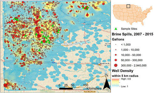
Map of western North Dakota that includes well density (number of wells per 5 km radius), reported brine spills from 2007 to 2015 (red circles), and sampling sites of samples collected in July 2015 (green triangles). Note the association between spill locations and well density, with higher occurrences of spills in areas of high well density. Spill data were compiled from the North Dakota Department of Health and include both contained and uncontained brine spills. Oil well data were downloaded from the North Dakota Industrial Commission, Oil and Gas Division. [Image source]
“In 2014, the Bakken region was producing an average of over 1 million barrels of oil per day, compared to production levels that consistently lingered at approximately 100 thousand barrels per day before 2007. This rapid rise in production has been made possible by intense development of oil and gas infrastructure in western North Dakota, including approximately 9700 unconventional wells that have produced an estimated 31.4 × 10 9 gallons (118.9 × 10 9 L) of oil and gas wastewater (OGW).”
In addition to the elevated concentrations of major elements—Na, Cl, Br—the study found Bakken brines are rich in “metals, metalloids and other potential contaminants” including Se, V, Sr, Li, B, Mn, Ni, Cd, Cu, Zn, Ba, Pb, Ra, NH4, all of which have “human and ecological health implications.”
NORM in the Bakken Brines and Impact on Spill Sites
Produced waters can have elevated levels of naturally occurring radioactive materials (NORM), primarily the long-lived radium isotopes 228Ra. Read More…
The study Brine Spills Associated with Unconventional Oil Development in North Dakota was conducted by the Division of Earth and Ocean Sciences, Nicholas School of the Environment, Duke University, Durham, N.C.
Posted in News Alert | Tagged: Bakken region, Brine Spills, fracking, human health, NORM, North Dakota, OGW | Leave a Comment »
Posted by feww on May 11, 2016
M5.0 quake strikes Bight Fracture Zone, Reykjanes Ridge
EQ Details
Magnitude 5.0 [USGS/EHP]
Location: 57.627°N 32.866°W
Time: 2016-05-10 17:21:02UTC
Depth: 23.6km
Distances:
- 765.0 km (475.3 mi) ESE of Nanortalik, Greenland
- 935.0 km (581.0 mi) SW of Reykjavik, Iceland
M5.5 quake strike NW of Gyamotang, China (TAR)
Magnitude: 5.5Mw [USGS/EHP]
Location: 32.038°N 94.987°E
Depth: 10.0 km
Time: 2016-05-11 01:15:47UTC
Distances:
- 70.0 km (43.5 mi) NW of Gyamotang, China
- 233.0 km (144.8 mi) WNW of Qamdo, China
- 429.0 km (266.6 mi) N of Along, India
- 723.0 km (449.3 mi) NE of Thimphu, Bhutan
‘Strong’ earthquake strikes 10km SE of Christchurch
Magnitude: 4.7 [geonet]
Location: 43.59°S, 172.70°E (10km southeast of Christchurch)
Depth: 7km
Universal Time: May 11 2016, 8:45:53
NZ Volcano Alerts
Volcano, Alert Level, Aviation Color Code
Ruapehu, 2, YELLOW
White Island, 1, YELLOW
Posted in News Alert | Tagged: Bight Fracture Zone, Christchurch, earthquake, Reykjanes Ridge, Tibet Autonomous Region, volcano alert | Leave a Comment »
Posted by feww on May 10, 2016
Reader Submitted Material
Second year of high rates of honey bee summer loss causing serious concern
U.S. beekeepers lost 44 percent of their honey bee colonies in the 12 months to April 2016, according to the latest preliminary results of an annual nationwide survey. Rates of annual loss including both winter loss and summer loss worsened compared with the previous year. Summer loss rates have now rivaled winter loss rates for the second consecutive survey year, reported the Bee Informed Partnership.
“We’re now in the second year of high rates of summer loss, which is cause for serious concern,” said an assistant professor of entomology at the University of Maryland and project director for the Bee Informed Partnership. “Some winter losses are normal and expected. But the fact that beekeepers are losing bees in the summer, when bees should be at their healthiest, is quite alarming.”
Beekeepers who responded to the survey lost a total of 44.1 percent of their colonies over the course of the year. This marks an increase of 3.5 percent over the previous study year (2014-15), when loss rates were found to be 40.6 percent. Winter loss rates increased from 22.3 percent in the previous winter to 28.1 percent this past winter, while summer loss rates increased from 25.3 percent to 28.1 percent.
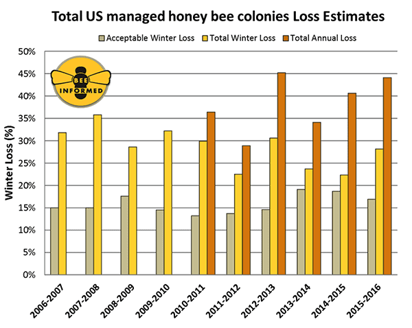
Summary of the total overwinter colony losses (October 1 – April 1) of managed honey bee colonies in the United States across nine annual national surveys. The acceptable range is the average percentage of acceptable colony losses declared by the survey participants in each year of the survey. Credit: Bee Informed Partnership/University of Maryland
“The high rate of loss over the entire year means that beekeepers are working overtime to constantly replace their losses,” said a senior entomologist at the USDA and a co-coordinator of the survey. “These losses cost the beekeeper time and money. More importantly, the industry needs these bees to meet the growing demand for pollination services. We urgently need solutions to slow the rate of both winter and summer colony losses.”
Multiple factors are contributing to colony losses including pesticides and malnutrition, especially among commercial colonies. However, the main culprit by far is varroa mite, a deadly parasite that easily spreads between colonies.
Source: Bee Informed Partnership/University of Maryland
Related Links
Posted in News Alert | Tagged: bee colony losses, Bee Informed Partnership, entomology, honey bee colonies, U.S. Beekeepers, Varroa mite | Leave a Comment »
Posted by feww on May 9, 2016
Sent by a reader in PSC
You would have thought the first requirement for serving as a senior government official is minimal common sense! Or was it integrity!
Seismicity in the “Popcorn State” is 600 times greater than it was prior to 2008
Center for Biological Diversity (CBD) has asked the U.S. Interior Secretary to revoke Oklahoma Oil, Gas Leases.
CBD Press Release: Interior Secretary Asked to Revoke Oklahoma Oil, Gas Leases
The Center for Biological Diversity today requested that the Bureau of Land Management pull 11 public fossil fuel leases sold last month in Oklahoma and Kansas over concerns that fracking and underground injection of oil wastewater could increase the risk of earthquakes in these areas, threatening the physical safety and homes of tens of thousands of residents.
In today’s letter to Interior Secretary Sally Jewell, the conservation group called on the BLM to withdraw the leases, covering more than 2,300 acres of federal oil and gas reserves in Oklahoma and Kansas, that were auctioned off April 20 in Santa Fe, N.M. Despite scientific evidence of skyrocketing injection-induced earthquakes in Oklahoma in recent years, the group points out, the BLM failed even to mention the problem of increased risk of human caused earthquakes in its Environmental Assessment for the lease auction, which violates the National Environmental Policy Act and could put people and property in harm’s way.
A new video posted on the Center’s website illustrates the recent spike in oil wastewater-induced earthquakes in Oklahoma on a statewide map. Initially, small circles representing seismic activity pop up sporadically, but then rapidly explode all over central and northern Oklahoma with increasing speed and size. A ticker counting the earthquakes also accelerates with time, tallying a total count of 6,116 earthquakes between May 2005 and April 2016.
“It’s clear that these man-made practices are increasing the amount of earthquake activity near and around drilling sites,” said Wendy Park of the Center. “Let’s not wait for an event that damages property or risks lives before acting to protect Oklahoma and Kansas residents. These dangerous seismic risks to communities are yet another reason for keeping dirty federal fossil fuels in the ground.”
Scientists say injections of oil wastewater can lubricate faults, triggering damaging earthquakes. A recent study by the U.S. Geological Survey evaluated the risk of damage from both natural and induced earthquakes in Oklahoma and other states, and the results show a startling rise in seismic activity since the region’s fracking boom began. The agency’s assessment suggests that there is a 5 percent to 10 percent chance of damaging shaking from mainly induced earthquakes in a swath of Oklahoma and Kansas. Read more…
Posted in News Alert | Tagged: Earthquakes, fracking, Induced earthquake, minimal common sense, Oklahoma Gas Lease, Oklahoma Oil lease, Popcorn State | Leave a Comment »
Posted by feww on May 9, 2016
M 5.2 quake strikes 136km WSW of Bamboo Flat, India
EQ Details
Magnitude: 5.2MW [USGS/EHP]
Location: 11.360°N, 91.511°E; depth=10.0 km (6.2 mi)
Time: 2016-05-09 16:03:47 (UTC)
Distances:
- 136.0 km (84.5 mi) WSW of Bamboo Flat, India
- 139.0 km (86.4 mi) WSW of Port Blair, India
- 687.0 km (426.9 mi) SW of Bogale, Burma
- 688.0 km (427.5 mi) SW of Mawlamyinegyunn, Burma
- 1,013.0 km (629.4 mi) WSW of Bangkok, Thailand
M4.6 strikes 20km WNW of Whakaari (White Island, NZ)
EQ Details
Magnitude: 4.6Mw [USGS/EHP]
Location: 37.447°S, 176.970°E; depth=106.4km (66.1 mi)
Date/ Time: 2016-05-09 at 07:27:04 (UTC)
Distances:
- 56.0 km (34.8 mi) N of Whakatane, NZ
- 75.0 km (46.6 mi) ENE of Tauranga
- 99.0 km (61.5 mi) NE of Rotorua
- 130.0 km (80.8 mi) NE of Tokoroa
- 466.0 km (289.6 mi) NNE of Wellington
Posted in News Alert | Tagged: Bamboo Flat, India, NZ, Port blair, The Dramatic Volcano, Whakaari, White Island | Leave a Comment »
Posted by feww on May 9, 2016
Extreme rain events lead to overflowing of multiple dams in Vratsa region, Bulgaria
State of emergency has been declared across northwestern Bulgaria’s municipalities of Mizia and Hayredin in Vratsa region, amid overflowing dams.
At least three dams—Rogozen, Rogozen-1 and Barzina—are overflowing after recent extreme rain events in the region, according to reports.
The regional governor of Vratsa has declared a state of emergency which is in force from 21 o’clock (EET) on Saturday to 21 o’clock (EET) on Monday.
Some of the people living in areas prone to flooding along the course of the Skat river have been evacuated.
Flooding turned deadly in the town of Mizia in August 2014, said reports.
.
Posted in News Alert | Tagged: Barzina, Bulgaria, dam, evacuation, extreme rain event, flooding, Rogozen, state of emergency, Vratsa region | Leave a Comment »
Posted by feww on May 8, 2016
CJ Members
Areas 4116, 3815 and 2314 deemed unstable —FIRE-EARTH Science Team
CJ Members and affiliates residing in Areas 4116, 3815 and 2314 are hereby placed under “Evacuation Alert.”
- Be ready to evacuate those areas at a short notice.
FEWW Science Team will host a special session with additional information on this Evacuation Alert, today (May 8, 2016) at 20:05UTC.
Previous Alerts
IMPORTANT NOTICE – IMPORTANT NOTICE – IMPORTANT NOTICE
- FIRE-EARTH BEACONS will begin beaming at 00:02UTC on May 18, 2016
——————————————————————-
NON-Members
The four-digit numbers representing FIRE-EARTH area codes are unique to our organization. Any similarities with 3rd-party area codes are purely coincidental.
Posted in News Alert | Tagged: 1139, 1702, 2538, 2815, 2952, BEACONS, CJ Members, evacuation alert, FEWW Science Team, FIRE-EARTH Channels, FIRE-EARTH Science Team, Important Notice | Leave a Comment »
Posted by feww on May 8, 2016
M5.9 quake occurs S of Santa Maria Asuncion Tlaxiaco, Mexico
Centered at 16.569°N, 97.694°W the quake occurred at a depth of 24.4 km (15.2 mi), reported USGS/EHP.
EQ Details
Magnitude: 5.9Mw [USGS/EHP]
Location: 16.569°N 97.694°W depth=24.4 km (15.2 mi)
Time: 2016-05-08 07:34:02 (UTC)
Distances:
- 29.0 km (18.0 mi) NE of Pinotepa de Don Luis, Mexico
- 44.0 km (27.3 mi) NE of Santiago Pinotepa Nacional, Mexico
- 77.0 km (47.8 mi) S of Santa Maria Asuncion Tlaxiaco, Mexico
- 78.0 km (48.5 mi) E of Ometepec, Mexico
- 351.0 km (218.1 mi) SSE of Mexico City, Mexico
Posted in News Alert | Tagged: Cordillera Neovolcánica, earthquake, Mexico, North American plate, Pinotepa de Don Luis | Leave a Comment »
Posted by feww on May 7, 2016
Federal Disaster Declared in
Arkansas Severe Storms, Tornadoes, Straight-line Winds, and Flooding (DR-4270)
- Incident period: March 08, 2016 to March 13, 2016
- Major Disaster Declaration declared on May 06, 2016
The federal government has declared a major disaster exists in the State of Arkansas in the area affected by severe storms, tornadoes, straight-line winds, and flooding during the period of March 8-13, 2016.
The areas that are worst affected include the counties of Arkansas, Ashley, Bradley, Calhoun, Chicot, Cleveland, Columbia, Desha, Lincoln, Ouachita, Phillips, and Prairie.
Additional designations may be made at a later date if requested by the state and warranted by the results of further damage assessments, officials said.
Major Disaster Declarations (2016)
- Texas Severe Storms, Tornadoes, and Flooding [DR-4266] March 17, 201
- Major Disaster Declared for Delaware [DR-4265] March 17, 201
- Louisiana Disaster Declaration Expanded March 17, 2016
- Major Disaster Declaration: New Jersey [DR-4264] March 15, 2016
- Major Disaster Declaration: Louisiana Severe Storms and Flooding March 14, 2016
- Federal Disaster Declared for Virginia [DR-4262] March 8, 2016
- Major Disaster Declarations for DC and Maryland [DR-4260, DR-4261 ] March 5, 2016
- Major Disaster Declaration Proclaimed for Georgia [DR-4259] February 27, 2016
- Major Disaster Declared for Oregon [DR-4258] February 19, 2016
- Major Disaster Declared for Alaska [DR-4257] February 18, 2016
- Major Disaster Declared for Oklahoma [DR-4256] February 12, 2016
- Major Disaster Declared for Texas [DR-4255] February 10, 2016
- Major Disaster Declaration Proclaimed for Arkansas [DR-4254] February 6, 2016
- Federal Emergency Declared for Louisiana (EM-3376) February 6, 2016
- Major Disaster Declaration Proclaimed for Washington [DR-4253] February 3, 2016
- Major Disaster Declaration Proclaimed for Idaho [DR-4252] February 2, 2016
- Major Disaster Declared for Alabama [DR-4251] January 23, 2016
- Oklahoma Oak Grove Fire (FM-5118)
- Major Disaster Declared for Missouri [DR-4250] January 22, 2016
- Federal Emergency Declared in Michigan [EM-3375] January 17, 2016
- Major Disaster Declaration for Washington [DR-4249] January 16, 2016
- Major Disaster Declared for Mississippi [DR-4248] January 5, 2016
- Federal Emergency Declared for Missouri [EM-3374] January 3, 2016
- Federal Disaster Declarations
- Drought
- Agricultural Disasters Index
Posted in News Alert | Tagged: Arkansas, DR-4270, flooding, major disaster, severe storms, straight-line winds, tornadoes | Leave a Comment »