Posts Tagged ‘U.S. Drought’
Posted by feww on May 7, 2016
Drought destroys crops in four counties across two U.S. states
The U.S. Department of Agriculture (USDA) has declared a total of four counties in Arizona and California as crop disaster areas due to damages and losses caused by a recent drought. Those areas are:
Arizona. Yuma, Pima and Maricopa counties.
California. Imperial County.
Notes:
i. USDA trigger point for a countywide disaster declaration is 30 percent crop loss on one or more crops.
ii. The counties designated as agricultural disaster areas, as listed above, include both primary and contiguous disaster areas.
iii. Some counties may have been designated as crop disaster areas more than once due to multiple disasters.
iv. The U.S. has a total of 3,143 counties and county-equivalents.
Previous Disaster Designations – 2016
- Crop Disasters Declared in Texas, Utah, Oklahoma, Nevada and Hawaii April 22, 2016
- Crop Disasters Declared in Montana; Wildfire Emergencies in Kansas, Oklahoma
- Crop Disasters Declared in North Carolina March 31, 2016
- Crop Disasters Declared in Oklahoma, Arkansas and Puerto Rico March 26, 2016
- Crop Disasters Declared in Florida, Georgia March 18, 2016
- Multiple Crop Disasters Declared in Nine U.S. States March 4, 2016
Posted in News Alert | Tagged: Arizona, california, crop disaster, drought 2016, drought disaster, U.S. Drought, USDA | Leave a Comment »
Posted by feww on December 24, 2015
Drought destroys crops in 53 counties across five states
Drought has destroyed or damaged crops in at least 53 counties across five states: California, Maine, Massachusetts New Hampshire and Vermont.
Disaster Designation # 1
The U.S. Department of Agriculture (USDA) has designated a total of 33 counties in California as crop disaster areas due to damages and losses caused by a drought that occurred during the period of Jan. 2, 2015, and continuing. Those counties are:
California: Alameda, Fresno, Humboldt, Inyo, Kern, Kings, Lake, Los-Angeles, Madera, Marin, Mariposa, Mendocino, Merced, Mono, Monterey, Napa, San-Benito, San-Bernardino, San-Francisco, San-Luis-Obispo, San-Mateo, Santa-Barbara, Santa-Clara, Santa-Cruz, Shasta, Siskiyou, Sonoma, Stanislaus, Tehama, Trinity, Tulare, Tuolumne, Ventura
Disaster Designation # 2
USDA has also designated a total of 20 counties across four states—New Hampshire, Maine, Massachusetts and Vermont—as crop disaster areas due to damages and losses caused by a recent drought that occurred during the period of Jan. 2, 2015, and continues. Those counties are:
New Hampshire. Belknap, Carroll, Cheshire, Coos, Grafton, Hillsborough, Merrimack, Rockingham, Strafford and Sullivan.
Maine. York County.
Massachusetts. Essex, Franklin, Middlesex and Worcester.
Vermont. Caledonia, Essex, Orange, Windham and Windsor.
All counties listed above were designated crop disaster areas on Dec. 23, 2015.
Crop Disasters 2015
Beginning January 7, 2015 USDA has declared crop disasters in at least 4,017 counties and county equivalents across 46 States [as well as Puerto Rico, and US Virgin Islands]: Those states are Arizona, Alabama, Arkansas, California, Colorado, Connecticut, Delaware, Florida, Georgia, Hawaii, Idaho, Illinois, Indiana, Iowa, Kansas, Kentucky, Louisiana, Maine, Massachusetts, Michigan, Minnesota, Mississippi, Missouri, Montana, Nebraska, Nevada, New Jersey, New Hampshire, New Mexico, New York, North Carolina, Ohio, Oklahoma, Oregon, Pennsylvania, Rhode Island, South Carolina, South Dakota, Tennessee, Texas, Utah, Vermont, Virginia, West Virginia, Washington and Wyoming.
- About 99 percent of the 2015 crop disaster designations have been due to drought so far this year.
Crop Disasters 2014
In 2014, USDA declared crop disasters in at least 2,904 counties across 44 states. Most of the designations were due to drought.
Those states were:
Alabama, Arizona, Arkansas, California, Colorado, Connecticut, Delaware, Florida, Georgia, Hawaii, Idaho, Illinois, Indiana, Iowa, Kansas, Louisiana, Maine, Massachusetts, Michigan. Minnesota, Mississippi, Missouri, Montana, Nebraska, Nevada, New Hampshire, New Jersey, New Mexico, New York, North Carolina, Ohio, Oklahoma, Oregon, Pennsylvania, Rhode Island, South Carolina, Tennessee, Texas, Utah, Vermont, Virginia, Washington, Wisconsin, and Wyoming. [FIRE-EARTH has documented all of the above listings. See blog content.]
Notes:
i. USDA trigger point for a countywide disaster declaration is 30 percent crop loss on at least one crop.
ii. The counties designated as agricultural disaster areas, as listed above, include both primary and contiguous disaster areas.
iii. Some counties may have been designated as crop disaster areas more than once due to multiple disasters.
iv. The U.S. has a total of 3,143 counties and county-equivalents.
Related Links
Posted in News Alert | Tagged: crop disaster, crop disaster 2015, Drought, U.S. Drought | Leave a Comment »
Posted by feww on October 23, 2015
D0-D4 drought conditions extend by 10.4 percent across CONUS since last week
Areas across the Contiguous United States covered by “Abnormally Dry” (D0) to “Exceptional Drought” (D4) levels have extended by about 10.4 percent since last week, according to the U.S. Drought Monitor.
The latest statistics for total US are 53.02 percent of the area as of October 20, up from 48.69 percent previously.
“Significant rain began to overspread the south-central U.S. on October 21, a day after the drought-monitoring period ended, and will be reflected in next week’s U.S. Drought Monitor.” said the Drought Monitor.

Source: http://droughtmonitor.unl.edu/
Posted in News Alert | Tagged: drought conditions, Exceptional drought, U.S. Drought | Leave a Comment »
Posted by feww on February 19, 2015
U.S. Drought Monitor Weekly Comparison Tables
Contiguous United States
| 2015-02-17 |
45.26 |
54.74 |
32.13 |
16.44 |
8.6 |
3.37 |
| 2015-02-10 |
47.51 |
52.49 |
29 |
16.18 |
8.49 |
3.27 |
West
| 2015-02-17 |
31.2 |
68.8 |
58.53 |
30.61 |
17.23 |
7.21 |
| 2015-02-10 |
30.41 |
69.59 |
52.65 |
30.63 |
17.1 |
6.96 |
California
| 2015-02-17 |
0.16 |
99.84 |
98.1 |
93.44 |
67.46 |
41.2 |
| 2015-02-10 |
0.16 |
99.84 |
98.1 |
93.44 |
67.46 |
39.99 |
South
| 2015-02-17 |
29.74 |
70.26 |
36.69 |
22.13 |
10.07 |
3.02 |
| 2015-02-10 |
42.31 |
57.69 |
33.75 |
20.56 |
9.71 |
3.02 |
High Plains
| 2015-02-17 |
46.61 |
53.39 |
20.18 |
5.51 |
0.3 |
0 |
| 2015-02-10 |
46.61 |
53.39 |
12.64 |
5.51 |
0.3 |
0 |
Intensity:
D0 – Abnormally Dry
D1 – Moderate Drought
D2 – Severe Drought
D3 – Extreme Drought
D4 – Exceptional Drought
Source: The National Drought Mitigation Center, Lincoln, NE
Posted in News Alert | Tagged: california, Drought, Drought Comparison, High Plains, South, U.S. Drought, Western U.S. | Leave a Comment »
Posted by feww on February 12, 2015
Drought disaster declared for five counties in the Virginias
The U.S. Department of Agriculture (USDA) has designated five counties in the two Virginias as crop disaster areas due to losses and damages caused by drought that occurred from June 1, 2014 through Oct. 31, 2014.
Drought disaster designations
- Virginia: Highland, Augusta and Bath counties.
- West Virginia: Pendleton and Pocahontas counties.
Crop Disasters 2015
Beginning January 7, 2015 USDA has declared crop disasters in at least 736 countiesiii across 14 states: Arizona, California, Colorado, Idaho, Kansas, Nebraska, Nevada, New Mexico, Oklahoma, Oregon, Texas, Utah, Virginia and West Virginia.
All of the 2015 disaster designations so far are due to drought.
Crop Disasters 2014
In 2014, USDA declared crop disasters in at least 2,904 counties across 44 states. Most of the designations were due to drought.
Those states were:
Alabama, Arizona, Arkansas, California, Colorado, Connecticut, Delaware, Florida, Georgia, Hawaii, Idaho, Illinois, Indiana, Iowa, Kansas, Louisiana, Maine, Massachusetts, Michigan. Minnesota, Mississippi, Missouri, Montana, Nebraska, Nevada, New Hampshire, New Jersey, New Mexico, New York, North Carolina, Ohio, Oklahoma, Oregon, Pennsylvania, Rhode Island, South Carolina, Tennessee, Texas, Utah, Vermont, Virginia, Washington, Wisconsin, and Wyoming. [FIRE-EARTH has documented all of the above listings. See blog content.]
Notes:
i. USDA trigger point for a countywide disaster declaration is 30 percent crop loss on at least one crop.
ii. The counties designated as agricultural disaster areas, as listed above, include both primary and contiguous disaster areas.
iii. Some counties may have been designated as crop disaster areas more than once due to multiple disasters.
iv. The U.S. has a total of 3,143 counties and county-equivalents.
v. The disaster designations posted above were approved by USDA on February 11, 2015.
Related Links
Posted in News Alert | Tagged: crop disaster, Drought, Drought 2015, drought disaster, U.S. Drought, Virginia, West Virginia | Leave a Comment »
Posted by feww on August 28, 2014
EXTREME WEATHER & CLIMATIC HAZARDS
RISING TEMPERATURES
SEVERE DROUGHT
CROP DISASTERS
SCENARIOS 900, 555, 444, 111, 101, 03, 02
.
Crop Disaster Declared for 7 Additional Texas Counties
The U.S. Department of Agriculture (USDA) has designated a total of seven counties in the Lone Star State as crop disaster areas due to severe drought.
The crop disaster designations are for El Paso, Kleberg, Brooks, Hudspeth, Jim Wells, Kenedy and Nueces counties.
Crop Disasters 2014
Beginning January 10, 2014 USDA has declared at least 2,262 separate crop disasters across 33 states. Most of those designations are due to the drought.
Those states are Alabama, Arizona, Arkansas, California, Colorado, Connecticut, Delaware, Florida, Georgia, Hawaii, Idaho, Iowa, Kansas, Louisiana, Massachusetts, Minnesota, Mississippi, Missouri, Montana, Nebraska, Nevada, New Jersey, New Mexico, New York, North Carolina, Oklahoma, Oregon, Pennsylvania, South Carolina Texas, Utah and Washington, Wyoming. [FIRE-EARTH has documented all of the above listings. See blog content.]
Notes:
i. USDA trigger point for a countywide disaster declaration is 30 percent crop loss on at least one crop.
ii. The total number of counties designated as agricultural disaster areas includes both primary and contiguous disaster areas.
iii. Counties may have been designated crop disaster areas more than once due to multiple disasters.
iv. The U.S. has a total of 3,143 counties and county-equivalents.
v. The disaster designations posted above were approved by USDA on August 27, 2014.
Crop Disaster Links
Posted in Climate Change, environment, global disasters | Tagged: crop disaster, Drought, drought disaster, Food Security, Texas, U.S. Drought, USDA | Leave a Comment »
Posted by feww on August 21, 2014
EXTREME WEATHER & CLIMATIC HAZARDS
RISING TEMPERATURES
SEVERE DROUGHT
CROP DISASTERS
SCENARIOS 900, 555, 444, 111, 101, 03, 02
.
Crop Disaster Declared for 9 Counties in Washington
The U.S. Department of Agriculture (USDA) has designated a total of nine counties in Washington state as crop disaster areas due to severe drought.
The crop disaster designations are for Yakima, Benton, King, Klickitat, Pierce, Grant, Kittitas, Lewis and Skamania counties.
Crop Disasters 2014
Beginning January 10, 2014 USDA has declared at least 2,255 separate crop disasters across 33 states. Most of those designations are due to the drought.
Those states are Alabama, Arizona, Arkansas, California, Colorado, Connecticut, Delaware, Florida, Georgia, Hawaii, Idaho, Iowa, Kansas, Louisiana, Massachusetts, Minnesota, Mississippi, Missouri, Montana, Nebraska, Nevada, New Jersey, New Mexico, New York, North Carolina, Oklahoma, Oregon, Pennsylvania, South Carolina Texas, Utah and Washington, Wyoming. [FIRE-EARTH has documented all of the above listings. See blog content.]
Notes:
i. USDA trigger point for a countywide disaster declaration is 30 percent crop loss on at least one crop.
ii. The total number of counties designated as agricultural disaster areas includes both primary and contiguous disaster areas.
iii. Counties may have been designated crop disaster areas more than once due to multiple disasters.
iv. The U.S. has a total of 3,143 counties and county-equivalents.
v. The disaster designations posted above were approved by USDA on August 20, 2014.
Crop Disaster Links
Posted in Climate Change, environment, global disasters | Tagged: crop disaster, Drought, U.S. Drought, USDA, Washington state | Leave a Comment »
Posted by feww on April 16, 2014
EXTREME CLIMATIC EVENTS
WORSENING DROUGHT
V. LOW SNOWPACK WATER CONTENT
WATER FAMINE
CROP DISASTERS
STATE OF EMERGENCY
.
Third of California water comes from snowpack
Snowpack provides about a third of the water used by California’s cities and farms. As of April 15, 2014, the California statewide water content of snowpack stood at only 24% of normal, according to the Department of Water Resource.
Drought causes water famine leading to crop disasters. It degrades water quality, and leads to surface and groundwater level declines, land subsidence, soil erosion, intense wildfires, humongous dust storms, and spread of disease.
Snow Water Equivalents
Statewide Summary
Provided by the California Cooperative Snow Surveys
Average snow water equivalent: 6.4″
Percent of April 1 average: 23%
Percent of normal for this date: 24%
Drought Information
Water years 2012 and 2013 were dry statewide, especially in parts of the San Joaquin Valley and Southern California. Water year 2014 continues this trend.
California’s Water Year 2014 (October 1, 2013 through September 30, 2014) has been one of the driest in decades and follows two consecutive dry years throughout the state. In most years, California receives about half of its precipitation in the months of December, January and February, with much of that precipitation falling as snow in the Sierras. Only a handful of large winter storms can make the difference between a wet year and a dry one.
In normal years, the snowpack stores water during the winter months and releases it through melting in the spring and summer to replenish rivers and reservoirs. However, relatively dry weather conditions this year have reduced the amount of snowpack in California’s mountains. Each of this season’s first four snow surveys – conducted in early January, late January, late February and early April – found a statewide snowpack water equivalent (WEQ) far below average for the dates of the surveys. —Calif. DoWR
State of Emergency
Governor Brown proclaimed a State of Emergency on January 27 amid the worsening statewide drought. He called the “really serious,” adding that 2014 could be California’s third consecutive dry year. “In many ways it’s a mega-drought.”
California State Resources
FIRE-EARTH 2009 Forecast: Desertification of California in the Near Future Is Almost a Certainty
[NOTE: The above forecast and most of the links posted below have previously been filtered/censored by Google, WordPress and others. Editor]
Related Links
Posted in Climate Change, Global Disaster watch, global disasters, Significant Event Imagery, significant events | Tagged: california, Drought, San Joaquin Valley, SNOWPACK WATER CONTENT, state of emergency, U.S. Drought, Water Year 2014 | Leave a Comment »
Posted by feww on September 26, 2013
Drought conditions improve slightly; near- to above-normal temps to persist nationwide
In the short term, temperatures are expected to rise 10 to 15 degrees above average from the Upper Great Lakes to part of the Middle Mississippi Valley; in contrast, temperatures will be 10 to 20 degrees below average from the Northern/Central High Plains to the Great Basin/Central Rockies, said NWS.
As of September 25, 2013, at least 1,345 counties and parishes, or 42.8% of all the U.S. counties and county equivalents, across 29 states remained agricultural disaster areas due to the drought, said USDA.

US Drought Map as of September 24, released by US Drought Monitor on September 26, 2013.
The Midwest: “By September 22, topsoil moisture was still rated by the U.S. Department of Agriculture at least half very short to short in Iowa (77%), Missouri (69%), Illinois (66%), South Dakota (62%), Nebraska (61%), and Wisconsin (55%). On the same date, USDA rated at least half of the pastures in very poor to poor condition in Iowa (62%) and Wisconsin (58%). And, more than one-quarter of the corn and soybeans were rated very poor to poor in Wisconsin (29 and 29%, respectively), Missouri (27 and 33%), and Iowa (27 and 29%).” U.S. Drought Monitor reported.
The Great Plains: “Despite all of the rain, rangeland and pastures across some parts of the Great Plains continued to suffer from the cumulative effects of multiple drought years. On September 22, rangeland and pastures were rated at least one-third very poor to poor several states, including Texas (54%), Colorado (43%), Nebraska (40%), and Kansas (36%).”
The Lower Mississippi Valley: “… topsoil moisture was still rated 41% very short to short in Arkansas and Louisiana, although those numbers represented a significant improvement from the previous week’s figures of 78 and 52%, respectively.”
The West: “No changes in the drought depiction were yet introduced in the Northwest, but the region will be monitored as precipitation continues to spread inland.”
Hawaii and Alaska: “From September 1-24, Hilo’s rainfall totaled just 2.17 inches (28% of normal). Near the southern tip of the Big Island, very poor pasture conditions led to degradation from severe to extreme drought (D2 to D3). […] Fairbanks reported its first autumn freeze (29°F) on September 15, followed 3 days later by its first measurable snowfall (0.6 inch). Meanwhile, heavy precipitation fell in non-drought areas of southeastern Alaska, where Ketchikan netted 12.22 inches of rain from September 15-23.”
Related Links
Posted in Climate Change, disaster watch, disaster watch 2013, environment, Global Disaster watch, global disasters, global disasters 2013 | Tagged: agricultural disaster areas, autumn freeze, Drought, drought and deluge, drought disaster, Lake Altus-Lugert, snowfall, U.S. Drought, U.S. Drought Monitor, US Drought, US drought 2013, US drought map | Leave a Comment »
Posted by feww on September 12, 2013
Lake Altus-Lugert drops to a historic low level of 12.6 percent of capacity: US Drought Monitor
As of September 10, 2013 about 63.75 percent of land area in the contiguous U.S. was covered by D0-D4 drought conditions, up from 61.71 percent last week, while more than half of the country was in moderate drought condition or worse, with about a third experiencing severe, exceptional or extreme drought levels, according to the U.S. Drought Monitor.

US Drought Map as of September 10, released by US Drought Monitor on September 12, 2013.
2013 Drought Disaster Areas
As of September 11, 2013 at least 1,338 counties and parishes, or 42.41% of all U.S. counties and county equivalents, were designated as agricultural disaster areas due to the ongoing drought.
[Note: The figure includes both primary and contiguous disaster areas.]
Drought Summary — Selected Regions — September 10, 2013
[Source: Mirrored from U.S. Drought Monitor with some editing]
- The Northeast: Continuing dry conditions prompted the introduction of abnormal dryness (D0) across central Maryland, southwestern Connecticut, and Long Island, N.Y., this week. According to AHPS, these areas have significant precipitation deficits at 180-, 90-, 60-, 30-, and 14 days. Streams and rivers are also running low, especially in central Maryland.
- The Midwest: Most of the Midwest remained dry this past week… Positive temperature departures of 4-8 degrees F were common throughout the region, with +10 degree F anomalies over portions of Iowa and southern Minnesota … widespread 1-category downgrades were made to the drought depiction across northern and southwestern Missouri, southern, central and eastern Iowa, parts of northern Illinois, northeastern and central Indiana, and central and southern portions of both Minnesota and Wisconsin.
- The Lower Mississippi Valley: Lack of rain during the past 7-days, temperatures 2-6 degrees above normal, and stream flow values in the lowest quartile of their historical distributions prompted 1-category degradations to the depiction across northern and western Louisiana, central and southern Arkansas, and northern and central Mississippi.
- Central and Northern Great Plains: One-category downgrades were warranted across southeastern Nebraska … In Kansas, the area of abnormal dryness (D0) in the northeast was expanded, and D0 conditions were added to southeast parts of the state.
- Southern Great Plains: Continuing dryness over north-central and northeastern Texas warranted a number of 1-category degradations. Texas, as dry weather has followed a reasonably wet summer in the region. In Oklahoma, 1-category downgrades were made across a significant portion of the state, with remaining drought-free areas in central and eastern Oklahoma deteriorating to abnormal dryness (D0). In Jackson County (southwest part of state)… Lake Altus-Lugert dropped to a historic low level of 12.6 percent of capacity.
- The Northwest: … the short-term gains have not offset long-term precipitation deficits… no change… in this area.
- Hawaii: A 1-categorydowngrade was warranted for western and southeastern sides of the Big Island of Hawaii…
- On the west side, it was reported that livestock and ornamental producers were having to haul water to sustain operations, which is very expensive and significantly reduces profits.
- On the southeast side of the Island, there were reports of crop stress.
- Alaska: No changes were made in Alaska this week.
Related Links
Posted in Climate Change, Global Disaster watch, global disasters, global disasters 2013, Significant Event Imagery, significant events | Tagged: agricultural disaster areas, Drought, drought and deluge, drought disaster, Lake Altus-Lugert, U.S. Drought, U.S. Drought Monitor, US Drought, US drought 2013 | Leave a Comment »
Posted by feww on September 6, 2013
Late growing season drought intensifies in Iowa, neighboring states: Report
Severe drought in Iowa increased to 32.07 percent up from 22.4 percent a week earlier, with 63.24 percent of the state covered in moderate drought or worse.

“After such an ideal start to the growing season, the past two months have been much drier than usual, with temperatures slowly increasing,” said David Miskus of U.S. Drought Monitor.
- Precipitation in central Iowa and northern Missouri was only 5 to 25 percent of normal, and as little as a tenth of an inch of rain.
- Iowa recorded its warmest week since July 2012, with highs of 104 degrees Fahrenheit at Des Moines and Fort Madison on Aug. 30.
- Iowa experienced its seventh driest August in 141 years of records, following the ninth driest July.
- Crop and pasture conditions began to deteriorate rapidly once heat was added to the dryness.
Small areas of severe drought also showed up in Illinois, Minnesota and Wisconsin this week.
- Drought also expanded or intensified in Mississippi, Oklahoma and on the Hawaiian island of Maui, during the week.
The portion of the drought-stricken areas in the U.S. corn belt increased from 45 to 52 percent during the week ending September 3, according to the U.S. Department of Agriculture’s meteorologist Brad Rippey, the report said.
- Soybeans in drought also increased in the last week, from 38 to 42 percent.
- Corn and soybeans in drought bottomed out in July at 17 and 8 percent, respectively.
- Cattle in drought increased one percent to 53 percent.
“Given that U.S. producers planted an estimated 97.4 million acres of corn and 77.2 million acres of soybeans in 2013, current drought figures suggest that more than 50 million acres (nearly 80,000 square miles) of corn and some 32 million acres (more than 50,000 square miles) of soybeans are presently being affected by drought,” Rippey said.
“According to USDA, nearly one-sixth of the U.S. corn (16 percent) and soybeans (15 percent) were rated in very poor to poor condition on September 1. A year ago, near the height of the Drought of 2012, very poor to poor ratings stood at 52 percent of the corn and 37 percent of the soybeans.”
As Midwest continued to dry out, parts of the Southwest and West saw scattered improvements from the monsoon season.
Overall, the portion of the contiguous United States in moderate to exceptional drought crept up to 50.09 percent from 50.04 percent a week earlier.
- The total land area in moderate drought increased to 17.69 percent, up from 16.67 previously.
- The area in exceptional drought shrank to 1.25 percent, down 0.07 percent from last week.
Related Links
Posted in Climate Change, disaster areas, disaster watch, disaster watch 2013, disaster zone, environment, Global Disaster watch, global disasters, global disasters 2013 | Tagged: Corn Belt, Drought, drought and deluge, drought disaster, growing season, Iowa, U.S. Drought, U.S. Drought Monitor, US Drought, US drought 2013 | Leave a Comment »
Posted by feww on August 29, 2013
62.34 pct of contiguous US experiencing drought or abnormally dry conditions
Drought and abnormally dry conditions covered about 62.34 percent of contiguous United States, up from 59.98 percent a week earlier.
The percentage of land areas in the lower 48 covered by “Extreme” and “Exceptional Drought” levels remained nearly unchanged, while the total areas covered by “Severe” and “Moderate Drought” levels increased by about 4.43 percent.

Meantime, USDA designated 39 additional counties in 5 states as agricultural disaster areas due to damage and losses caused by the recent drought.
- Texas: Cherokee, Rusk, Smith, Van Zandt, Wood, Anderson, Gregg, Houston, Panola, Angelina, Harrison, Hunt, Rains, Camp, Henderson, Kaufman, Shelby, Franklin, Hopkins, Nacogdoches and Upshur counties.
- Colorado: Eagle, Garfield, Lake, Routt, Grand, Pitkin and Summit counties.
- Oregon: Curry, Coos, Douglas and Josephine counties.
- California: Del Norte County.
- Idaho: Jerome, Cassia, Gooding, Lincoln, Minidoka and Twin Falls counties.
All counties listed above were designated natural disaster areas Aug. 28, 2013. The lists include both primary and contiguous disaster areas.

Map of the U.S. Drought Disaster areas as of August 28, 2013. At least 1,336 counties, or 42.5% of all U.S. counties¹, were designated as agricultural disaster areas² due to the ongoing drought. [The figure includes both primary and contiguous disaster designations.] Source: USDA. Map enhanced by FIRE-EARTH.
1. [U.S. has a total of 3,143 counties and county-equivalents.]
2. Agriculture officials declare disaster when crop damage has exceeded 30 percent.
UPDATED: September 6, 2013 – MAP CORRECTED!
Related Links
Posted in disaster watch, disaster watch 2013, disaster zone, environment, global deluge, Global Disaster watch, global disasters, global disasters 2013, global drought | Tagged: Agricultural disaster, Drought, drought and deluge, drought disaster, U.S. Drought, U.S. Drought Map, U.S. Drought Monitor, US Drought, US drought 2013 | Leave a Comment »
Posted by feww on August 22, 2013
Abnormally Dry to Severe Drought levels expand; Extreme to Exceptional Drought levels retreat
Abnormally Dry to Severe Drought levels spread in the contiguous United States, while areas covered by Extreme to Exceptional Drought levels retreat.

US Drought Map as of August 20, 2013, released by US Drought Monitor on Thursday August 22, 2013.
Agricultural Disaster Designations due to the Drought
At least 1,333 counties across 28 states have now been designated agricultural disaster areas due to the ongoing drought so far this year. [The figure includes both the primary and contiguous drought disaster areas. ]

U.S. Drought Disaster Map as of August 21, 2013. At least 1,333 counties, or 42.41% of all U.S. counties*, were designated as agricultural disaster areas due to the ongoing drought, a rise of 0.41% (16 counties) since last week. [The figure includes both primary and contiguous disaster designations.] Source: USDA. Map enhanced by FIRE-EARTH.
*[U.S. has a total of 3,143 counties and county-equivalents.]
Related Links
Posted in Climate Change, environment, global deluge, Global Disaster watch, global disasters, global disasters 2013, global drought | Tagged: Agricultural disaster, Drought, drought and deluge, drought disaster, Drought in Southern US, Drought in Western U.S., U.S. Drought, U.S. Drought Map, U.S. Drought Monitor, US Drought, US drought 2013 | Leave a Comment »
Posted by feww on August 22, 2013
16 Additional Counties Designated as Agricultural Disaster Areas
At least 1,333 counties across 28 states have now been designated agricultural disaster areas due to the ongoing drought so far this year. [The figure includes both the primary and contiguous drought disaster areas. ]
U.S. Drought Disaster Map as of August 21, 2013. At least 1,333 counties, or 42.41% of all U.S. counties*, were designated as agricultural disaster areas due to the ongoing drought, a rise of 0.41% (16 counties) since last week. [The figure includes both primary and contiguous disaster designations.] Source: USDA. Map enhanced by FIRE-EARTH.
*[U.S. has a total of 3,143 counties and county-equivalents.]
Related Links
Posted in disaster watch, disaster watch 2013, disaster zone, disasters, Global Disaster watch, global disasters, global disasters 2013 | Tagged: agriculture disaster, Drought, drought and deluge, drought disaster, Drought in Southern US, Drought in Western U.S., U.S. Drought, U.S. Drought Map, U.S. Drought Monitor, US Drought, US drought 2013 | Leave a Comment »
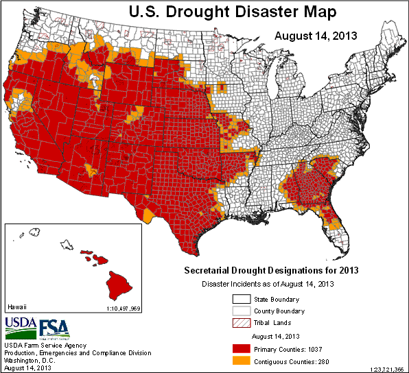
Posted by feww on August 16, 2013
U.S. drought down fractionally, but more counties designated drought disaster areas
- As of August 13, 2013 about 57.30 percent of contiguous United States were affected by drought conditions, down slightly from 57.40 percent a week earlier.
- Some 45.26 percent of the land areas were covered by Moderate Drought (D1) to Exceptional Drought (D4), down from 45.49 percent.

US Drought Map as of August 13, 2013, released by US Drought Monitor on August 15, 2013.
Map of U.S. Drought Disaster Areas
As of August 14, 2013 at least 1,317 U.S. counties were designated as primary or contiguous agricultural disaster areas due to the ongoing drought.

U.S. Drought Disaster Map as of August 14, 2013. At least 1,317 counties, or 42% of all counties*, were designated as drought disaster areas. [The figure includes both primary and contiguous disaster designations.] Source: USDA. Map enhanced by FIRE-EARTH.
*[U.S. has a total of 3,143 counties and county-equivalents.]
Related Links
Posted in disaster watch, disaster watch 2013, disaster zone, disasters, Global Disaster watch, global disasters, global disasters 2013 | Tagged: Drought, drought and deluge, drought disaster, Drought in Southern US, Drought in Western U.S., U.S. Drought, U.S. Drought Map, U.S. Drought Monitor, US Drought, US drought 2013 | Leave a Comment »
Posted by feww on August 9, 2013
Extreme Drought, Abnormally Dry Levels in Lower 48 Expand Marginally
Areas covered by various drought levels in contiguous United States expanded marginally in the week ending August 6, 2013. D0 – D4 Drought levels covered 57.40 percent of the lower 48, up from 57.23 percent previous period.
The region worst affected by the drought was the South, where Exceptional Drought expanded to 3.75 percent, up from 3.04 percent earlier. The region’s D0 – D4 drought levels also expanded to 74.44 percent, up from 73.81 percent a week earlier.

US Drought Map as of August 6, 2013, released by US Drought Monitor on August 8, 2013.
Related Links
Posted in Global Disaster watch, global disasters, global disasters 2013, Significant Event Imagery, significant events | Tagged: Drought, drought and deluge, drought disaster, Drought in Southern US, Drought in Western U.S., Dry conditions, U.S. Drought, U.S. Drought Map, U.S. Drought Monitor, US Drought, US drought 2013 | Leave a Comment »
Posted by feww on August 2, 2013
Drought intensifies in Nevada, Oregon, Utah and the Dakotas
Drought intensified in the U.S. West over the past week.
D0-D4 drought levels generally persisted in California, Colorado, Idaho, Louisiana, Montana, Nebraska, Wyoming, Arizona, Alaska and Hawaii, but eased slightly in Texas and New Mexico.

Drought conditions improved more significantly in Oklahoma, covering 52.77 percent of the state, down from 75.08 percent previously. In Arkansas, D0 – D2 drought areas were 71.01 percent, down from 90.94 percent last period. Kansas down to 87.80 percent, compared with 100 percent a week ago.
As of July 30, 2013, drought levels in the lower 48 improved slightly covering 57.23 percent of contiguous U.S., down from 58.30 percent previously.
Dry conditions in Iowa covered 70.18 percent of the land, up from 62.92 percent earlier.
As of July 31, 2013 some 1,295 U.S. counties across 28 states were designated as drought disaster areas by USDA. [The figure includes both primary and contiguous disaster designations.]
Related Links
Posted in Global Disaster watch, global disasters, global disasters 2013, Significant Event Imagery, significant events | Tagged: Drought, drought and deluge, drought disaster, drought in South, Drought in Southern US, Drought in Western U.S., Dry conditions, Montana Drought Disaster, U.S. Drought, U.S. Drought Map, U.S. Drought Monitor, US Drought, US drought 2013 | Leave a Comment »
Posted by feww on July 26, 2013
Drought and dry conditions expand in the U.S. South, West, Midwest and High Plains
The areas in contiguous U.S. that are covered by ‘Abnormally Dry’ thru ‘Exceptional Drought’ (D0 – D4 on the Drought Monitor scale) have expanded to 58.30 percent for the week ending July 23, 2013, up from 54.39 percent a week earlier.
Abnormally dry areas in the U.S. Midwest, including the top crop state of Iowa, reached 18.94 percent, up from 7.16 percent.
Iowa has experienced a triple fold increase in the areas covered by abnormally dry condition, reaching 62.9 percent, compared to 19.8 percent earlier.
Dry conditions have also expanded in Arkansas, Louisiana, Minnesota and Missouri.
Five additional Montana counties have been designated as agricultural disaster areas due to damages and losses caused by the expanding drought.

US Drought Map as of July 23, 2013, released by US Drought Monitor on July 25, 2013.
About 64 percent of the topsoil in Arkansas was rated short or very short of moisture, with 24 percent of the state’s pasture and rangeland in poor or very poor condition.
California had 95 percent of its pasture and rangeland in poor or very poor condition. Colorado 64 percent, Kansas 55 percent, Texas 44 percent and Arizona had 79 percent so rated, according to July 22 U.S. Department of Agriculture crop progress report.
“Missouri had 60 percent of the topsoil short or very short of moisture, and Iowa had 57 percent so rated, which was a jump of 22 percent since last week.”
Related Links
Posted in Global Disaster watch, global disasters, global disasters 2013 | Tagged: Drought, drought and deluge, drought disaster, drought in South, Drought in Southern US, Drought in Western U.S., Dry conditions, Montana Drought Disaster, U.S. Drought, U.S. Drought Map, U.S. Drought Monitor, US Drought, US drought 2013 | Leave a Comment »
Posted by feww on June 27, 2013
USDA declares drought disaster in 19 additional counties in four states
The U.S. Department of Agriculture (USDA) has designated a total of 19 counties in four states—Colorado, New Mexico, Texas and California—as agricultural disaster areas due to damages and losses caused by the ongoing drought.
The latest designations, issued on June 26, include both primary and contiguous disaster areas.
- Colorado: Archuleta, Mineral, Conejos, Hinsdale, La Plata,
Rio Grande and Saguache counties.
- New Mexico: Rio Arriba and San Juan counties.
- California: San Diego, Imperial, Orange and Riverside counties.
- Texas: Reeves, Culberson, Jeff Davis, Loving, Pecos and Ward counties.

U.S. Drought Disaster Map as of June 26, 2013. A total of at least 1,267 counties across 28 states are currently designated as [primary or contiguous] drought disaster areas.
Related Links
Posted in Global Disaster watch, global disasters, global disasters 2011, global disasters 2013, U.S. Disasters | Tagged: agricultural disaster areas, Drought, drought and deluge, Drought Map, U.S. Drought, U.S. drought and deluge, U.S. Drought Disaster, U.S. Drought Disaster Map, US disaster areas, US Drought, US drought 2013, US drought map | Leave a Comment »
Posted by feww on June 13, 2013
U.S. Drought Disaster Spreads
USDA has designated 31 additional counties across seven states as Agricultural Disaster Areas due to damages and losses caused by several ongoing drought. The designations include both primary and contiguous disaster areas.
A total of at least 1,266 counties across 28 states are currently designated as [primary or contiguous] drought disaster areas.
The latest disaster designations are in the following states
- Texas
- Colorado
- Arizona
- Utah
- New Mexico
- Oregon
- Nevada

U.S. Drought Disaster Map as of June 12, 2013. A total of at least 1,266 counties across 28 states are currently designated as [primary or contiguous] drought disaster areas.
Related Links
Posted in Global Disaster watch, global disasters, global disasters 2013 | Tagged: agricultural disaster areas, Drought, drought and deluge, Drought Map, U.S. Drought, U.S. drought and deluge, U.S. Drought Disaster, U.S. Drought Disaster Map, US disaster areas, US Drought, US drought 2013, US Drought and Deluge, US drought map | 1 Comment »
Posted by feww on January 26, 2013
DISASTER CALENDAR SYMBOLIC COUNTDOWN: 1,141 Days Left
[January 26, 2013] Mass die-offs resulting from human impact and the planetary response to the anthropogenic assault could occur by early 2016.
- SYMBOLIC COUNTDOWN: 1,141 Days Left to the most Fateful Day in Human History
- Symbolic countdown to the ‘worst day’ in human history began on May 15, 2011 …
.
Global Disasters/ Significant Events
“We are eating grasshoppers”
Severe flooding, triggered by week-long extreme rain events in South Africa and Zimbabwe, continued to spread across southern Mozambique.
“The number of displaced people now stood at 67,995 while nearly 85,000 have been affected by the raging waters in recent days, the UN said, urging donors to urgently make more funds available ‘to help deal with this emergency’ in the impoverished southeast African nation.”
Hunger is setting in among tens of thousands of the victims who are waiting for help to arrive, said a report.
“We are eating grasshoppers,” a flood victim told AFP, adding that she believed they were the “lucky ones.”
“We have family in the town, our aunts. They must be on the rooftops now,” she said.
“We left at midnight without taking food. We have nothing to sleep under.”
The Great Crocodile Escape
A crocodile farm in northern South Africa was forced to open its gates after being inundated, letting loose at least 15,000 crocodiles.
Australia
Several ‘mini-tornadoes’ spawned by the remnants of cyclone Oswald have hit the Queensland coast injuring about two dozen people, as severe weather and flooding batters the disaster state.
The tornadoes have damaged scores of homes and forced the evacuation of towns around Bundaberg, reports said.
- Tornadoes caused severe damage to coastal townships of Bargara and Burnett Heads, both of which have since been declared disaster areas.
Further north, severe flooding in Gladstone led to the city (population ~ 30,000) being declared a disaster zone, and the authorities told at least 2,000 people to evacuate.
Oklahoma, USA
The drought in Oklahoma has caused more than $2 billion in damage in the past two years, said a report.

Oklahoma Drought Map. Source: Drought Monitor Archives
- “Cities are facing water rationing, and Tulsa residents will see dying lawns, trees and plants.”
- It cost twice as much to feed the livestock. “A load of feed, which lasts about a month, has gone from about $3,500 to $7,500.”
- USDA has declared 917 counties as primary and contiguous drought disaster areas including the entire state of Oklahoma and parts of 25 other states, in January 2013.

High Plains Drought Map. Source: Drought Monitor Archives
GLOBAL WARNINGS
Global Disasters: Links, Forecasts and Background
Posted in Global Disaster watch, global disasters, global disasters 2013 | Tagged: Back-to-Back Australian Disasters, Bundaberg, cyclone Oswald, disaster zone, Drought 2013, drought and deluge, drought in Oklahoma, extreme rain event, flooding in Mozambique, Gaza province, Gladstone, High Plains Drought Map, Humanitarian Crisis, hunger, Mozambique floods, Oklahoma collapse, Oklahoma Drought Map, Queensland flooding, South Africa, tornadoes, U.S. Drought, water rationing, Zimbabwe | Leave a Comment »
Posted by feww on January 18, 2013
Colorado, Kansas, Nebraska and Oklahoma plagued by severe drought or worse
Severe drought has spread to 87.25 percent of the High Plains, up from 86.20 percent previous week, with 61.27 percent of the region rated in extreme drought, up from 60.25 percent.
- The entire land area in Colorado, Kansas, Nebraska and Oklahoma is currently affected by severe drought or worse.

U.S. Drought Map for 15 January 2013, released by U.S. Drought Monitor on January 17, 2013.
About 58.87 percent of the contiguous United States was in at least “moderate” drought as of January 15, according to the U.S. Drought Monitor.
Oklahoma declares a state of emergency amid persistent drought
About 16,000 residents in rural Payne, Pawnee, and Lincoln counties are running out of water, prompting emergency managers to declare states of emergency.
- The water level at Lone Chimney Lake, the area’s only source, has dropped under four feet—11.5 feet below normal, reports said.
- “This month the small Oklahoma farming town of Wapanucka lost water completely when the spring-fed wells the community relies on ran dry. Officials closed schools and residents had to do without tap water until the town could run a line to a neighboring water district.”
“Last summer’s extreme weather locked two-thirds of the U.S. continental land mass in severe drought, cutting production of the biggest crop, corn, by 27 percent from early-season estimates,” said a report.
Drought Links
GLOBAL WARNING
.
DISASTER CALENDAR SYMBOLIC COUNTDOWN: 1,149 Days Left
[January 18, 2013] Mass die-offs resulting from human impact and the planetary response to the anthropogenic assault could occur by early 2016.
- SYMBOLIC COUNTDOWN: 1,149 Days Left to the most Fateful Day in Human History
- Symbolic countdown to the ‘worst day’ in human history began on May 15, 2011 …
.
Posted in Global Disaster watch, global disasters, global disasters 2012, global disasters 2013, global drought | Tagged: 2012 Drought Disaster, 2013 Drought Disaster, carrying capacity, Drought, drought and deluge, drought disaster, Drought Disaster 2013, human impact, Lincoln, Oklahoma drought, Oklahoma State of emergency, Pawnee, Payne, U.S. Drought, U.S. Drought Disaster, Wapanucka | Leave a Comment »
Posted by feww on January 17, 2013
DISASTER CALENDAR SYMBOLIC COUNTDOWN: 1,150 Days Left
[January 17, 2013] Mass die-offs resulting from human impact and the planetary response to the anthropogenic assault could occur by early 2016.
- SYMBOLIC COUNTDOWN: 1,150 Days Left to the most Fateful Day in Human History
- Symbolic countdown to the ‘worst day’ in human history began on May 15, 2011 …
.
Global Disasters/ Significant Events
Dozens of additional counties across 8 states declared drought disaster areas
The U.S. Department of Agriculture (USDA) has designated dozens of additional counties across 8 states as drought disaster areas. The designations include both primary and contiguous disaster areas.
- The latest designations are for counties in the states of Texas, Oklahoma, Nebraska, Missouri, Kansas, Georgia, Florida and Alabama.
- Drought Disaster 2013 has now spread to at least 904 counties across 27 states: Alabama, Arizona, Arkansas, California, Colorado, Florida, Georgia, Hawaii, Idaho, Illinois, Iowa, Kansas, Minnesota, Missouri, Montana, Nebraska, Nevada, New Mexico, North Carolina, North Dakota, Oklahoma, Oregon, South Carolina, South Dakota, Tennessee, Texas and Wyoming.
Previous Drought Entries
Deadly floods paralyze Indonesian capital, Jakarta
A state of emergency was declared by the new governor of Jakarta as severe flooding triggered by days of heavy rain inundated large parts of the Indonesian capital Jakarta, blocking roads and forcing up to 100,000 people from their homes.
- Many businesses and government offices, especially in the capital’s central business district, were forced to close because staff could not get to work. Dozens of schools have told their students to stay at home.
- At least half dozen people have been killed in the extreme rain and flood-related incidents so far.
- “Rain will continue to fall in the greater Jakarta area … the potential for flooding remains,” a spokesman for the Meteorology Climatology Meteorology and Geophysics Agency told Reuters.
GLOBAL WARNINGS
Global Disasters: Links, Forecasts and Background
Posted in Global Disaster watch, global disasters, global disasters 2013, global drought | Tagged: 2012 Drought Disaster, 2013 Drought Disaster, BNPB, carrying capacity, Drought, drought and deluge, drought disaster, Drought Disaster 2013, human impact, Indonesian floods, Jakarta flooding, U.S. Drought, U.S. Drought Disaster, USDA, USDA disaster declaration | Leave a Comment »
Posted by feww on January 13, 2013
DISASTER CALENDAR SYMBOLIC COUNTDOWN: 1,154 Days Left
[January 13, 2013] Mass die-offs resulting from human impact and the planetary response to the anthropogenic assault could occur by early 2016.
- SYMBOLIC COUNTDOWN: 1,154 Days Left to the most Fateful Day in Human History
- Symbolic countdown to the ‘worst day’ in human history began on May 15, 2011 ...
.
Global Disasters/ Significant Events
Drought disaster declared for dozens of counties across MN, MT, ND and SD, flue emergency in NY
The U.S. Department of Agriculture (USDA) has declared as drought disaster areas dozens of counties across Minnesota, Montana North and South Dakotas. The designations follow damages and losses caused by the recent drought.
Health emergency declared in NY state amid flu epidemic
New York State has declared a public health emergency, as a severe influenza outbreak tightened its grip across the country.
- About 20,000 cases of flu have been reported statewide so far this season, a rise of nearly 4 folds on the last season (4,400 confirmed cases in 2012).
- “We are experiencing the worst flu season since at least 2009, and influenza activity in New York State is widespread, with cases reported in all 57 counties and all five boroughs of New York City,” Governor Cuomo said in a statement. “Therefore, I have directed my Administration, the State Health Department and others to marshal all needed resources to address this public health emergency and remove all barriers to ensure that all New Yorkers – children and adults alike – have access to critically needed flu vaccines Gov. Cuomo said .
- Public health officials in NY announced last week that flu-related illnesses had reached epidemic levels, killing at least 20 children nationwide.
- CDC estimates that from the 1976-1977 flu season to the 2006-2007 season, flu-associated deaths each season ranged from a low of about 3,000 people to a high of about 49,000 people.
- Twenty-four states and New York City are now reporting high ILI activity. Additionally, 16 are reporting moderate levels of ILI activity. States reporting high ILI activity for the week ending January 5, 2013 include Alabama, Colorado, Delaware, Georgia, Illinois, Iowa, Kansas, Louisiana, Michigan, Minnesota, Mississippi, Missouri, New Jersey, New Mexico, North Carolina, North Dakota, Oklahoma, Pennsylvania, Rhode Island, Tennessee, Texas, Utah, Virginia, and West Virginia, CDC said.
GLOBAL WARNINGS
Global Disasters: Links, Forecasts and Background
Posted in Global Disaster watch, global disasters, global disasters 2013, global drought, global health catastrophe | Tagged: 2012 Drought Disaster, 2013 Drought Disaster, carrying capacity, CDC, Drought, drought and deluge, drought disaster, flu virus, H3N2, Heat Domes, human impact, Influenza, influenza A (H1N1), influenza B, influenza-like-illness, U.S. Drought, U.S. Drought Disaster, U.S. Drought Map, USDA, USDA disaster declaration | Leave a Comment »
Posted by feww on January 11, 2013
U.S. Drought Map for January 8, 2013
FEWW DROUGHT FORECAST: REMOVED BY A MODERATOR.
As of January 8, 2013 drought covered more than 60 percent of the contiguous U.S. and rendered a further 11.5 percent as ‘Abnormally Dry,’ according to the U.S. Drought Monitor.
- ‘Severe’ to ‘Exceptional’ drought levels plagued more than 86 percent of High Plains including
- 100 percent of Nebraska
- 100 percent of Kansas
- Nearly 97 percent of South Dakota
- More than 86 percent of Wyoming
- Over 95 percent of Colorado
- More than half of southern United States including the entire state of Oklahoma and about two-thirds of Texas were also experiencing ‘Severe’ to ‘Exceptional’ drought conditions.
- At least 44 percent of the West, a third of the Midwest and a fifth of the Southeast also reported similar drought conditions.

U.S. Drought Map for 8 January 2013, released by U.S. Drought Monitor on January 10, 2013.
Recent Drought Links
- US: Dozens of Additional Counties Designated Disaster Areas December 4, 2012
- U.S. Drought: 54 Additional Counties Declared Drought Disaster Areas Posted November 2, 2012
- U.S. Counties Declared Disaster Areas October 25, 2012
- U.S. drought retreats fractionally, expected to persist through winter October 19, 2012
- U.S. Crop Disaster Losses Spreads to 2,673 Counties October 18, 2012
- Drought Disaster Spreads to 2,423 U.S. Counties October 12, 2012
- U.S. Drought: Little Change! October 4, 2012
GLOBAL WARNING
Posted in Global Disaster watch, global disasters, global disasters 2013, global drought, global heating | Tagged: 2012 Drought Disaster, 2013 Drought Disaster, carrying capacity, Drought, drought and deluge, drought disaster, Heat Domes, Hottest Hell on Earth, human impact, snowstorms, U.S. Drought, U.S. Drought Disaster, U.S. Drought Map, US Drought Monitor | Leave a Comment »